
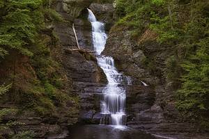
The Havasupai tribe grounds in Arizona are well known for having some of the world’s most stunning waterfalls and are currently among the most popular travel destinations in the state. The turquoise waters that cut through the Grand Canyon’s floor produce some of the most beautiful photo opportunities against the backdrop of the red, steep cliffs and desert landscape. This is the home of the incredible jaw-dropping Beaver Falls in Arizona. This waterfall stands out with its massive 50-foot drop! A huge flood in early 1910 destroyed it, creating a series of ledges and pools.
Below you’ll find an in-depth guide on everything you need to know about visiting the stunning Beaver Falls Arizona, including how to get a permit!
Where is Beaver Falls Arizona?
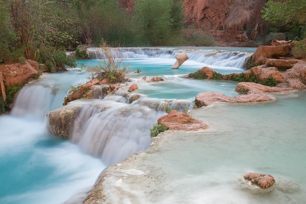
Beaver Falls AZ in the Havasupai Indian Reservation is worth the 13-mile hike.
©iStock.com/KiraVolkov
The Havasupai Indian Reservation, a remote area of the Grand Canyon, is Beaver Falls, Arizona’s location. You must travel 60 miles on Indian Route 18 to reach the trailhead. Apart from a few wild horses, there is nothing at all along this route.
To get to the Havasupai campground, you must climb for roughly 13 miles into the Grand Canyon from the Hualapai Hilltop trailhead. The magnificent Beaver Falls is a three-mile nature-filled hike away from there.
Do You Need a Permit for Beaver Falls?
The simple response is yes. Visitors must obtain a permit in order to go down the canyon and explore the five Havasupai waterfalls, including Beaver Falls. Day hiking is completely prohibited on Havasupai land.
Your overnight reservation at the Havasu Lodge or the Havasupai campground serves as your authorization to travel across the Havasupai territory. Each of these places to stay will be wonderful for anyone who loves spending time in the great outdoors. While booking lodgings, consider that most of the cascades are closer to the Havasupai campground.
The Best Time to Hike Beaver Falls
Beaver Falls, Arizona, is breathtaking every day of the year. Let’s compare the advantages of beginning your journey at various times of the day. Visitors who have already been to the area advise beginning their trek to Beaver Falls, Arizona, as soon as possible. In the summer, the milder early temperatures make hiking much more enjoyable.
Fewer people are around you, and the light will be ideal for taking beautiful pictures. You will reach Beaver Falls, Arizona, by mid-afternoon, which is the ideal time for swimming if you start your journey in the late morning or early afternoon.
Because the waterfalls are most crowded in the afternoon, prepare to share this sanctuary with other hikers who want to unwind and enjoy the tranquil waters. Locals advise against beginning your hike in the late afternoon or evening because it takes a few hours to complete.
Locating Beaver Falls in Havasu Creek in the evening might be challenging, and it is not recommended to trek up to Mooney Falls after dark. However, if you find yourself on the trail after dark, ensure you have a headlight and enough light to return.
Can You Drive to Beaver Falls?
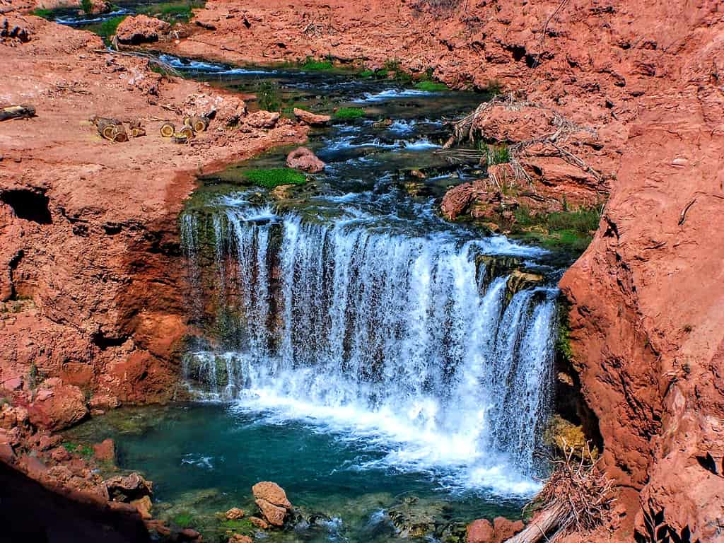
Beaver Creek Falls Arizona is on the Havasupai reservation.
©iStock.com/Jeremy Christensen
Although you cannot drive directly to the falls, you will have to drive to Indian Route 18 to get to the trailhead. To reach Beaver Falls, you can travel a number of short trails that all converge in the same general area. You must descend to the foot of Mooney Falls and follow the stream into the canyon in order to reach Beaver Falls.
The creek now continues to flow into the canyon if you are at the base of Mooney. When looking downstream, continue along the bank’s left side. As an alternative, there are routes that go to higher terrain while still staying on the creek’s path. Just be mindful that there are a lot of side bushes, dried trees, and spiky vegetation.
Crossing the Creek
In any case, after a somewhat rocky descent down, the path above the creek also ultimately descends to the creek bank once more. You are good and going in the right direction if you are close to the creek. From Mooney Falls, the trail is roughly three kilometers away. You’ll ultimately reach a point where you must go in and traverse the creek once you’re back down by the water in the shade.
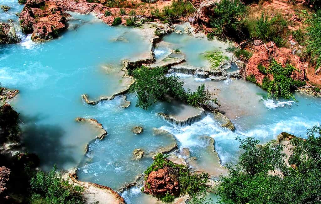
The canyon walls are in front of you, and the creek bank stops here, so there is no question you need to cross. People play about and take pictures close to a very little waterfall and the canyon walls at this somewhat wide crossing. Here, the lake is milky blue and incredibly beautiful.
Finding Beaver Falls
When you cross, the track briefly departs from the creek, but it quickly returns thanks to a number of small bridge crossings over wooden planks and soaked boards. You might get a little wet on some of these, but you won’t get too soaked thanks to the bridge crossings.
When the path transitions into a large open space of wild grapes and their enormous leaves and vines, it is one of the trail’s most spectacular spots. This overgrown forest of vibrant green leaves in the basin of the red canyon just gives you the impression that you’re in another universe!
Due to their height, you may occasionally need to crouch under the leaves as well. The trail turns upward once more, and there is a substantial wooden plank that you can use to cross a narrow gorge at one point. You’ll come upon the important landmark after hiking for a while. After you pass the palm tree, turn left. Avoid climbing the ladder.
There is a tiny water oasis with some incredibly clear water here after passing through a small tunnel to get to the palm tree. It’s official: you’ve arrived at your destination! You can still descend from the peak of Beaver Falls to the bottom, but you’ll have to straddle the canyon wall and essentially rock climb your way down.
How Much Does It Cost to Make a Reservation at Beaver Falls?
Visiting the breathtaking Havasupai Falls is by permit only.
©iStock.com/Jeremy Christensen
Although the precise cost varies from year to year, we calculate that the permit will cost each individual between $350 and $500. The standard requirement is for a minimum stay of three nights and four days.
All cancellation and transfer fees are non-refundable in full. There are additional fees for the weekends, holidays, and spring break. It is advised to stay at least two nights if you intend to hike in and out in order to have enough rest and sufficient time to see Beaver Falls.
You must already be camping at Havasu in order to access Beaver Falls. The tribe forbids day hikes down the canyon, and arrangements must be established before your arrival with the Havasupai tourism office to avoid being forced to turn back after the eight-mile trek to Supai from Hualapai Hilltop.
You will receive a wristband at Supai that serves as proof of your reservation. This wristband must always be worn while swimming in the pools and trekking on Havasupai tribal property.
Can You Swim in Beaver Falls?
After you get to Beaver, it’s time to go swimming! Before returning to the campsite, stay as long as you can here. Alternately, if you’re feeling particularly daring, stop here for a moment before heading north to the Colorado River’s confluence. Although it may be enticing, it is not permitted to leap off the falls, and serious harm is very likely.
How Long Does It Take To Hike To Beaver Falls?
The Havasupai Indian reservation offers two hiking experiences, but be careful.
©iStock.com/Colleen Bradley
From the foot of Mooney Falls, the actual climb to Beaver Falls, Arizona, is around 6 miles round trip. The most difficult and remote Havasupai waterfall to access.
Since it is a day hike, allow at least seven hours. You should have ample time to take it easy at the waterfall and enjoy the hike. You must add another two hours if you begin at Havasu Lodge.
When ascending and descending the Mooney Falls route, plan on waiting. There is virtually no room for two-way traffic on this brief but extremely technical section of the path.
The photo featured at the top of this post is © iStock.com/KiraVolkov
How to Add Us to Google News


Thank you for reading! Have some feedback for us? Contact the AZ Animals editorial team.