
If you’ve experienced an earthquake, you know the unsettling feeling that overcomes your body when the earth shifts beneath your feet. Sometimes, earthquakes feel like sudden jolts; other times, they may feel like a rolling rumble. They may last only a few seconds or go on long enough to make you panic. And earthquakes in California are no exception.
Earthquakes can be terrifying, especially the first time you feel one. California has a history of destructive quakes and there’s always the threat of the “big one.” But in a state where tremors occur regularly, what is the number one town most likely to experience an earthquake?
What is an Earthquake?
An earthquake is a powerful trembling in the earth’s outmost layer. You’re accustomed to this layer, as it’s what you witness from your perspective living on land. However, the Earth is made up of a total of four layers. These layers include:
- Crust
- Mantle
- Outer core
- Inner core
The outermost layer together with the tough outer layer of the mantle makes up a region called the lithosphere. It’s easy to picture this layer of the earth as unbroken, all the way around. But this layer is made of tectonic plates, which are like huge pieces that form a kind of mosaic, fitting nicely together but not continuously. Below this broken-up layer is the mantle, which is thick, soft, and in a flowing state.
Since the mantle layer is constantly moving, the crust of the earth feels it. When eventually the pressure gets to be too much, the earth’s outer core cracks. These cracks are called faults. Then, when tectonic plates shift, the movement is felt at those existing cracks or faults. That is what creates an earthquake. There’s a lot that goes on beyond the surface. However, the earth’s crust shifting at a fault zone causes the rumbling and jolts you feel during a tremor.
Fault Lines in California
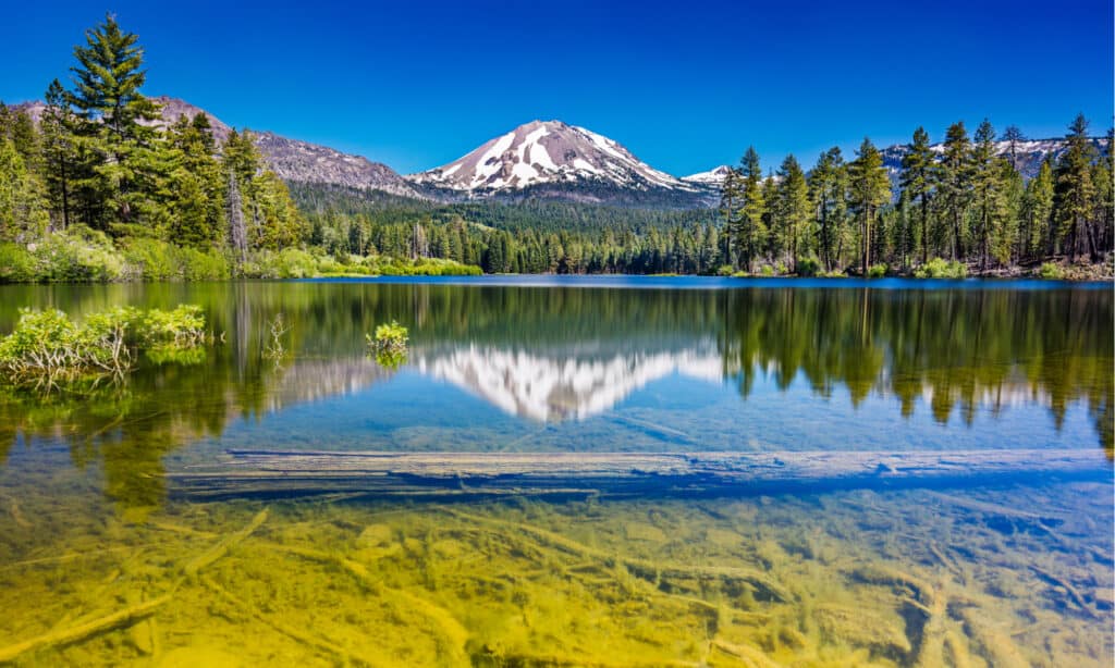
Lassen Peak experienced eruptions in the early 20
thcentury but has since remained dormant.
©H Peter Ji Photographer/Shutterstock.com
The most well-known fault line in California is the San Andreas Fault. It runs south to north in this vertically shaped state. Although the most notorious, it’s certainly not the only fault line in the state that has caused damage. Although this fault runs south to north, it deviates right around the mountains in Santa Barbara. This area is often referred to as the Transverse Range. Pressure tends to accumulate right around this area, causing a number of earthquakes.
In recent years, the Sierra and Southern Cascades have revealed additional faults. This region sits on the east side of Lake Tahoe and has been active with earthquakes for well over a hundred years. In 2021, there was a 6.0 magnitude earthquake near Markleeville. This reminded Californians that some spots are more likely to experience earthquakes than others.
There are other indicators of earthquake-prone lands that include the number of volcanoes and hot springs in the area. For example, Lassen Peak experienced eruptions in the early 20th century but has since remained dormant. That doesn’t mean it won’t awaken, however. Other areas that geologists are keeping an eye on include Mt. Shasta and Mammoth Lakes.
Vulnerable Towns in California
In California, nearly 16,000 faults have been discovered with 500 of them active. When two fault lines converge, the likelihood of an earthquake skyrockets. There are two major faults in California that meet — the San Andreas Fault and the San Jacinto Fault. The possibility of these two faults cracking at the same time provides a dismal outlook. Due to its proximity to both of these faults, a couple of areas would see dire consequences, including San Bernardino.
Eureka is another town with worrisome proximity to faults. However, just north of Los Angeles is “The Grapevine.” It concerns geologists because it’s the location of the most severe earthquakes over the last 100 years in the state. This environment is dense with both people and buildings. But there’s another city in California that is also prone to earthquakes and has a dense population: San Francisco.
One town in California has a population of only 18 (mostly ranchers and farmers). This town is situated right on the San Andreas Fault. In fact, they observe the fault line as a dry creek bed. There’s a bridge that crosses over the creek and since it was built in 1936, either side of the bridge has shifted over 5 feet due to seismic activity. This town is no stranger to 6.0 magnitude earthquakes. And eerily, they have quite an interesting motto: “Be here when it happens.”
#1 Town Most Likely to Experience an Earthquake in California
Mcgee Creek has an earthquake index of 167.57. This value is determined based on the past earthquake events in this area. Out of all the cities in California, Mcgee Creek is the number one earthquake spot. This town is situated right in the center of the state and sits at 7,723 feet. It covers only four square miles and is probably best known for its gorgeous views and boldly colored wildflowers.
How Earthquakes Impact Wildlife

A recent study demonstrated that sperm whales’ hunting abilities were disrupted for as long as a year following earthquakes.
©wildestanimal/Shutterstock.com
Although there isn’t a consensus about whether or not earthquakes can be accurately predicted, there have been reports of wildlife sensing impending tremors. They typically respond by leaving their nesting areas just before quakes start. Animals that use the earth for cover, including their eggs, can be seriously impacted following an earthquake in the case of a landslide. Earthquakes even have the capacity to impact whales! A recent study demonstrated that sperm whales’ hunting abilities were disrupted for as long as a year following earthquakes. Depending on the severity of an earthquake, animals may be buried alive, crushed, or drown.
Where is McGee Creek Located on a Map?
McGee Creek covers only four square miles and has a population of only 18 mostly ranchers and farmers. This town is situated right on the San Andreas Fault. This town is no stranger to 6.0 magnitude earthquakes.
The photo featured at the top of this post is © Everett Collection/Shutterstock.com


How to Add Us to Google News


Thank you for reading! Have some feedback for us? Contact the AZ Animals editorial team.