
Commonly known as the Rockies, the Rocky Mountains are the primary mountain systems stretching from western Canada to the southwestern US state of New Mexico. The Interior Plateau and Coast Mountains of Canada, as well as the Columbia Plateau and Basin and Range Province of the United States, border the Rockies on the west. The Great Plains border the mountain ranges on the east. The Rocky Mountains vary in width from 70 to 300 miles (110 to 480 kilometers) and measure 3,000 miles (4,800 kilometers) long.
With towering landscapes that take real adventurers to new heights, it’s no surprise that the Rockies are world-renowned for their spectacular scenery. At an elevation of 14,440 feet (4,401 meters) above sea level, Mount Elbert, located in Colorado, is the range’s highest peak, followed by Mount Massive at an elevation of 14,428 feet.
Forest lands and public parks protect much of the mountain range, making it one of the most popular tourist destinations, especially for mountaineering, mountain biking, hiking, snowboarding, skiing, snowmobiling, hunting, fishing, and camping. Let’s explore more about how these incredible mountain ranges were formed.
When were the Rocky Mountains formed?
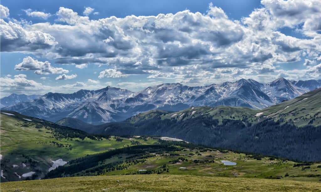
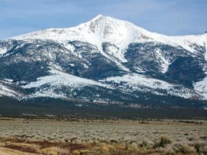
The Rockies were formed during the Laramide orogeny, starting around 80 to 50 million years ago and ending roughly 35 million years ago.
©Anna Krivitskaya/Shutterstock.com
The Rockies were formed during the Laramide orogeny, starting around 80 to 50 million years ago and ending roughly 35 million years ago. The mountain ranges took shape during an intense period of plate tectonic activity, leading to a more rugged landscape in western North America.
Extensive volcanism mudflows soon followed this mountain-building event and ash falls that left behind igneous rocks in the Never Summer Range. There have been two significant periods of glaciation over the last 300,000 years. The Bull Lake Glaciation occurred about 300,000-127,000 years ago, while the Pinedale Glaciation Period happened 30,000-12,000 years ago.
How were the Rocky Mountains formed?
The rocks in the mountain ranges were formed before tectonic forces raised the Rocky Mountains. The oldest metamorphic rocks, such as gneiss and schist, started developing about 1.7 billion years ago during the Precambrian Era. Shortly afterward, a large volume of magma pushed into the older rock around 1.6 billion years ago, resulting in the Boulder Creek Batholith, which is why you’ll find lots of metamorphic rocks within the Rockies that may have been caused by regional metamorphism.
Inland seas covered much of the present-day north during the Precambrian era, leading to the deposition of marine sediments that would later become limestone and sandstone. The mountain-building processes raised the ancient Rocky Mountains around 285 million years ago. These ancestral Rocky Mountains stretched from Boulder to Steamboat Springs in Colorado and were much smaller than the modern Rockies. The ancient Rockies then eroded hundreds of millions of years ago, leaving behind a less rugged landscape and sedimentary deposits such as the Fox Hills Formation and Pierre Shale. For 100 million years, the entire state of Colorado was submerged under the Western Interior Seaway.
The current Rockies arose in the Laramide Orogeny that began between 80 and 50 million years ago. This process uplifted the modern Rocky Mountains and was followed by further tectonic activity. A series of erosions during the Tertiary Period continued to raise the mountain ranges to their present height. They removed massive amounts of sediment, revealing the ancestral rocks beneath and forming the current landscape of the Rocky Mountains.
Periods of glaciations have occurred over the last 300,000 years and are responsible for shaping the Rockies, especially the Rocky Mountains National Park as it is today. As mentioned earlier, recent glaciations include the Bull Lake Glaciation, which happened between 300,000 and 127,000 years ago, and the Pinedale Glaciation Period, which took place from 30,000 to 12,000 years ago. As a result, the Rockies are now defined by many broad U-shaped valleys and cirques.
What plates formed the Rocky Mountains?
The Farron plate slid underneath the North American plate at the beginning of the Laramide orogeny.
©Pat Tr/Shutterstock.com
The Farron plate slid underneath the North American plate at the beginning of the Laramide orogeny. This low angle shifted the focus of the melting and mountain building farther inland under the continental interior, releasing water into the lithosphere above. Water lowers the melting points of rocks, so the sinking Farron plate caused the newly melted magma to migrate upward into the lithosphere. These tremendous thrusts piled sheets of crust on top of each other, resulting in broad, tall Rocky Mountain ranges.
How were the Canadian Rockies formed?
The mountain building was similar to pushing a rug on a hardwood floor for the Canadian Rockies- the rug bunches up and forms wrinkles. In this case, the wrinkles refer to the mountain ranges, the Canadian Shield in the middle of the continent is the hardwood floor, and the rug refers to the ancestral rocks. Over 100 million years ago, during the closure of an ocean basin off the west coast, the North American continent was dragged westward and collided with a microcontinent, forming the Canadian Rockies. Thick sheets of Paleozoic limestone were thrust eastward over Mesozoic rocks.
Did the Rocky Mountains or the Great Plains form first?
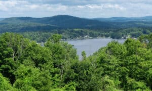
The Rocky Mountains are bordered by the Great Plains towards the east.
©iStock.com/AlbertoLoyo
The formation of the Great Plains began over a billion years ago, in the Precambrian Era. The plains are by no means a small unit, formed when numerous small continents joined. The widespread uplift then carved them up to the west and in the Black Hills, which caused rivers to drain the highlands, eroding the landscape. The Rocky Mountains were formed much later and are bordered by the Great Plains towards the east. The Plains are situated west of the Mississippi River and are widely covered with grassland, steppe, and prairie.
Are the Rocky Mountains still rising?
The Rocky Mountains continue to rise due to buoyant forces, though in a way not easily perceived as the Himalayas. Some parts of the Rockies gradually erode and deposit on the high plains. The slow erosion might eventually make the areas surrounding the Rockies less lumpy over time. Other mountain ranges like the Taiwan Central Range, Olympic Mountains, and the Southern Alps are still actively growing, though not getting much taller than they already are.
The photo featured at the top of this post is © iStock.com/chapin31
How to Add Us to Google News


Thank you for reading! Have some feedback for us? Contact the AZ Animals editorial team.