
A mudslide, sometimes known as a mudflow, is a geologic occurrence in which wet, flowing forces of fine-to-coarse-grained material flow downslope quickly and turbulently, typically in a drainage way. These forces of nature are often disastrous, inflicting natural and industrial damages wherever they flow and sometimes even claiming lives as they pass. In the United States, mudslides and landslides are not uncommon. However, they happen significantly less often in the US than in other countries. But among the instances when mudslides occurred in the country, which of them are the most destructive?
To determine which mudflows are the worst in the United States, we must first differentiate a mudslide from a landslide. Although the two terms may seem similar, they are not. Disturbances in the natural equilibrium of a slope generate landslides. They may occur in conjunction with severe rainfall or earthquakes, droughts, or volcanic eruptions. On the other hand, mudslides are landslides that occur in the presence of water. Also known as mudflow or debris flow, they occur when water builds quickly in the ground, causing a surge of water-soaked rock, earth, and debris. Mudslides are frequently triggered by natural calamities and start on hillsides. This article will uncover the 8 most destructive mudslides in the United States, the states most prone to landslides, and other facts.
The 8 Most Destructive Mudslides in the United States
1. 2014 Oso Mudslide
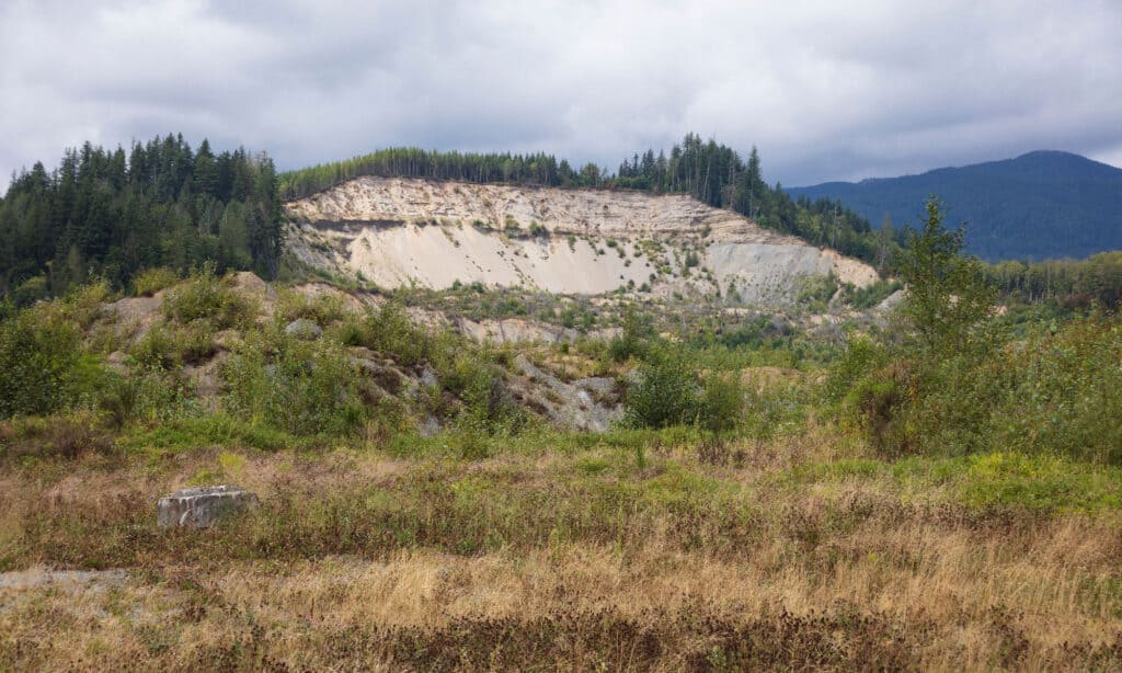
The Oso Mudslide is considered the worst and most destructive mudslide in the history of the United States.
©SandraG/Shutterstock.com
On March 22, 2014, a massive landslide struck 4 miles (6.4 km) east of Oso, Washington. A section of a rocky hill collapsed, spreading mud and debris south across the North Fork of the Stillaguamish River, enveloping a rural community and spanning about 1 square mile (2.6 km2). A total of 43 persons perished and 49 dwellings and other structures were destroyed. Until today, the Oso Mudslide of 2014 is considered the worst and most destructive mudslide in US history.
With up to 70 feet of muck, the mud engulfed the city of Oso, burying part of the Stillaguamish River and a mile-long length of state highway 530. According to witnesses, a massive wall of mud rushed through the ravine.
Over 100 rescuers from Snohomish County and neighboring towns, along with the Navy’s search and rescue team headquartered at adjacent Naval Air Station Whidbey Island, were called to help with emergency medical search-and-rescue activities. Landslide recovery operations involved approximately 600 people, including more than 160 volunteers.
2. 2018 Southern California Mudflows

23 people lost their lives to the 2018 Southern California Mudflow.
©U.S. Coast Guard District 11 PADET Los Angeles District 11 PADET Los Angeles / public domain
Early in January 2018, a series of mudslides hit Southern California, wreaking havoc on regions northwest of Montecito in Santa Barbara County. The incident claimed the lives of 23 people, while one of the victims’ bodies has never been located. The mudslides cost at least $177 million (in 2018 dollars) in property destruction, $7 million in emergency response costs, and another $43 million in cleanup costs. A total of 163 persons were sent to the hospital with various injuries, and four of them were in severe condition. The catastrophe ripped through homes and streets and destroyed more than 100 homes.
A quick-moving yet intense winter storm exacerbated the potential of mudflows in the vicinity and triggered evacuation orders as the Thomas Fire, which was at the time the worst wildfire in California history, raged for more than a month across Santa Barbara and Ventura counties.
3. 1982 Santa Cruz Mountains, California Mudslide
A large mudslide in Love Creek on the night of January 5, 1982, wrecked thirty homes and killed ten people. 18,000 landslides were caused by a single, devastating downpour in the San Francisco Bay Area. The most devastating of these landslides occurred in the Santa Cruz Mountains’ Love Creek area, where a 1000-foot slab of thickly vegetated hillside tumbled down on sleeping residents of Love Creek Heights without warning.
Love Creek is a California creek that begins at around 1,000 feet above sea level and runs south through the town of Ben Lomond in Santa Cruz County, before joining the San Lorenzo River south of Ben Lomond. It is located on the higher land side of the business district, making flooding a potential concern.
4. 1969 Nelson County, Virginia Mudslide
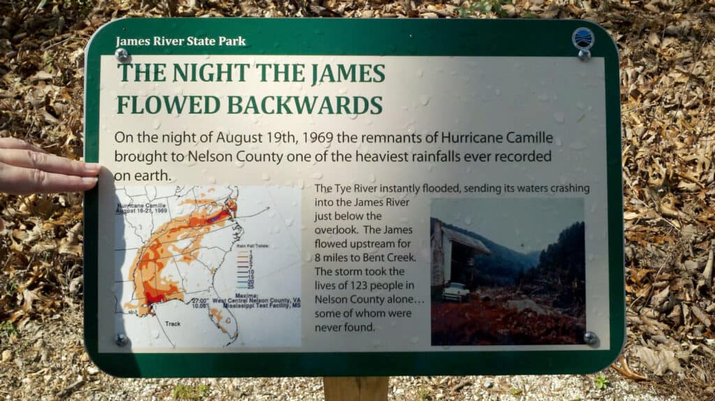
The 1969 Nelson County Mudslide is considered one of the biggest natural disasters in Virginia’s history.
©Virginia State Parks staff / Creative Commons – License
Hurricane Camille’s remnants dumped at least 710 mm (28 in) of rain on Nelson County, Virginia, in about 8 hours in 1969, causing several debris floods, making it one of the biggest natural catastrophes in the state’s nearly 400-year history. These remnants halted against a high-pressure system in central Virginia as they moved east across the Appalachian highlands from the Gulf Coast. The heavy rains resulted in debris flows and severe flooding, killing 150 people, most of them in Nelson County. Roads, bridges, communication infrastructure, houses, farms, and cattle were severely destroyed by the debris flows and floods.
Virginians have had more chances to learn and experience the dangers of debris flows in their state since 1969. Storms and heavy rains caused debris floods and substantial damage in the Upper Potomac and Cheat River Basins of West Virginia and Virginia in 1985. In 1995, a string of storms hit central Virginia, encompassing Madison County, in a single week.
5. 2021 Oregon Coast Mudslide
When mudslides closed highways and ambushed some campers on the Oregon Coast in November 2021, the Coast Guard launched a rescue mission. RVs were sitting in 6 inches of water in an RV park southwest of Portland, and the depth in some areas had reached 4 feet. Prior to this time, flood warnings and mudslide alerts had been issued.
Otis was a couple of miles away from this camping site near Neskowin Creek. A year prior, Otis had been completely devastated by a wildfire. As a result, there was a considerable risk of mudslides and landslides forming and spreading to the adjacent areas. Wildfire-ravaged areas are at risk of being carried away by mudslides. In the event of sudden rains and flooding, it is recommended to avoid such areas or establish active safety practices.
Rescue attempts are frequently hampered by the pace of mudflows, and more lives may be lost as a result. Fortunately,
6. 2014 Colorado’s Grand Mesa Mudslide
After two days of rain, a mudslide in the unoccupied slide area on Grand Mesa, Colorado, began on US Forest Service property. A mountain section broke loose, dumping a wall of snow, rocks, and splintered lumber into a rural private property region inaccessible to the public. Three persons went missing after the gigantic, miles-wide mudslide rushed down a mountain in rural western Colorado. No structures have been officially damaged, and no evacuations have been required because the region is unoccupied.
7. 2021 Colorado Highway Mudslides
Mudslides caused “severe damage” to Interstate 70 in Glenwood Canyon, Colorado, on July 29, 2021, prompting transportation officials to close the road and encourage long-distance trucks to take Interstate 80 north through Wyoming. The mudslides clogged the interstate with rocks and logs, posing a risk of flash flooding. Many areas in the west faced an increased flood danger resulting from that burned away vegetation and exposed hillsides to runoff. The avalanche of debris crashing down the canyon’s steep slopes broke portions of the concrete road and ripped a long section of steel guardrail away. There were no fatalities, thankfully. However, after the mudslides in western Colorado, more than 100 individuals were forced to spend the night on the roadway, including roughly 30 who sought sanctuary in a tunnel.
8. 1996 Willamette Valley, Oregon Mudslides
The 1996 Willamette Valley claimed the lives of eight people.
©Steve Morgan / Creative Commons – License
After the huge storm of 1995-1996, one of the earliest mudslides in Oregon was reported. The storm wreaked havoc on Oregon’s 18 counties, including Douglas County, causing major floods and property devastation. In Portland, there were over a hundred mudslides. Almost 22,000 individuals had to be evacuated after their homes were destroyed and approximately 8 persons died. Almost 5 inches of rain poured along the Central Oregon Coast, killing over 700 livestock. The mudslides also caused traffic congestion by closing Interstate 5 at the time.
What State Has the Most Mudslides?
Although a landslide of any type (mudslides included) might naturally occur with steep terrain, some parts of the country are more vulnerable than others.
Slides can happen in any state, although the Rocky Mountains, Appalachian Mountains, and Pacific Coastal Ranges are more prone to mudslide and landslide problems. According to the EPA, California, Washington, Alaska, Oregon, and Hawaii are among the particularly vulnerable states. Landslides can occur in any location made of particularly soft or broken materials lying on a steep slope.
While the apparent factors that trigger mudslides cannot be naturally eliminated, excellent engineering practices, geology investigations, and efficient implementation of land-use operational guidelines can help limit the risk of landslides. Landslide susceptibility maps are still being created by the United States Geological Survey (USGS) scientists for numerous sites around the country. Scientists from the USGS monitor flood frequency in every state, documenting variations in sediment load transported by rivers and streams due to slides. Hydrologists with experience in debris and mudflows are researching these threats in volcanic areas.
What is the Largest Landslide in US History?
The eruption of Mount St. Helens volcano in Washington in 1980 resulted in the biggest landslide in recorded history. The North Fork Toutle River landslide had a volume of 0.67 cubic miles of material, and it went 14 miles. With a maximum depth of 600 feet, the average landslide level was 150 feet. The landslide was moving at 70-150 miles per hour.
The photo featured at the top of this post is © iStock.com/Svetlana123


How to Add Us to Google News


Thank you for reading! Have some feedback for us? Contact the AZ Animals editorial team.