
The state of Oregon offers breathtaking scenery, from the vast expanses of its deserts to the Cascade mountains and shores of the Pacific Coast. Oregon offers some of the best infrastructure in the country for taking the two-wheeled path. Riders can pedal their way through the landscape with a choice of over 80 biking trails throughout the state. Whether you’re into road biking, off-street paved rides or adventurous mountain biking trails; there’s a path for you.
Oregon is also the only state in the country with official Scenic Bikeways! These are routes that are deemed the best bike rides in Oregon and showcase incredible scenery, state history, and local communities. These routes travel through state parks, on paved paths and roads, and cross mountain passes and high deserts. The Oregon Scenic Bikeway program is the first of its kind in the country. While not designated an official scenic bikeway route, the longest biking trail in Oregon is a unique ride of its own, designed to provide unparalleled access through the remote wonders of Oregon by bicycle!
The Longest Biking Trail in Oregon: The Oregon Timber Trail
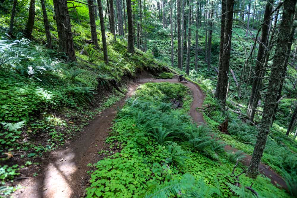
The Oregon Timber Trail is the longest biking trail in Oregon, spanning an incredible 670 miles South to North from the border of California to Washington.
©CSNafzger/Shutterstock.com
While there are a plethora of long trails to choose from throughout the state, the Oregon Timber Trail has them all beat in terms of length. The Oregon Timber Trail is the longest biking trail in Oregon, spanning an incredible 670 miles northbound from the California border up to the Washington border. It’s a backpacking challenge in which you’ll gain over 67,000 vertical feet and ride through some of the most stunning and remote areas of the state.
The Oregon Timber Trail is a well-designed and well-maintained trail that offers riders an incredible experience in traveling through diverse backcountry landscapes and provides a connection with off-the-beaten-path communities rich with history. The trail was designed to be ridden from South to North, but riders successfully traveled in the opposite direction with a little modification.
How Long Does it Take to Complete the Oregon Timber Trail?
The nearly 700 miles trail can be completed in roughly 20-30 days. However, if you would like a taste of the trail without committing to its entirety, you can take on smaller sections or just go on a day ride.
The trail is divided into four tiers and was inspired by the Pacific Crest Trail and other trails within the National Scenic Trail System. The four tiers OTT is divided into are the Fremont Tier, Willamette Tier, Deschutes Tier, and Hood Tier.
Some choose to traverse the entire route, either at their own pace or by timing the ride and doing the whole thing as fast as they can. Others choose to ride a segment or tier at a time and explore the route slowly over time. Tier Loops are designed to be covered over the course of 2-5 days. It’s also possible to ride without bike-packing gear by traveling to a Gateway Community for rides that are only a couple of hours long.
Planning for Riding the OTT

The Oregon Timber Trail Alliance offers a lengthy route guide as well as a wealth of other resources to help you prepare for the endeavor.
©iStock.com/LuckyBusiness
Although this trail was designed as a mountain biking route, the entirety of it is multi-use. Hikers, hunters, equestrians, and backpackers may all be present on the trail at one point or another. The trail is more than 60 percent singletrack and was conceived of as a bike-packing route in which gear is carried for the duration of the roughly month-long journey.
The Oregon Timber Trail Alliance offers a lengthy route guide as well as hundreds of detailed route files. This information has been accumulated over a period of years and is provided to riders at no cost. However, despite the incredible wealth of support, the alliance offers in planning, the route is still developing and unrefined. It’s important that riders are up for challenges and set out ready to adapt to the unexpected. Detours and trail closures should be checked for in advance.
If planning on undertaking the OTT, riders should be physically prepared and have some backcountry experience. Riders often plan the journey for months before embarking. The route winds through some wild and remote landscapes where encounters with wildlife, extremes of weather, and having adequate supplies are all challenges to consider.
Racing the OTT
The OTT is a self-timed Individual Time Trial race. There is no entry fee, support, or prize money for participating. What is provided for racers is a route description, suggested start time, and a list of results. It’s recommended that those participating do donate to the Oregon Timber Trail Alliance in order to support the trails continued improvement so that riders can enjoy the route for years to come.
The Oregon Timber Trail Route
The Four Tiers
The Oregon Timber Trail is divided into tiers based on the landscape and forests it travels through. These are:
| Tier 1 | Fremont Tier | Starts at the highest point in Oregon and traverses the 140 mile Fremont National Recreation Trail. Stunning views from Winter Rim and the opportunity to stay at remote fire lookouts along the way. |
| Tier 2 | Willamette Tier | The dry, volcanic eastern side of the Cascade Range. Bend is famous for world-class mountain bike trails. The Oregon Timber Trail takes advantage of these as it leaves Waldo Lake and winds through the Cascade Lakes region and around Mt. Bachelor. |
| Tier 3 | Deschutes Tier | Dry, volcanic eastern side of the Cascade Range. Bend is famous for world-class mountain bike trails. The Oregon Timber Trail takes advantage of these as it leaves Waldo Lake and winds through the Cascade Lakes region and around Mt. Bachelor. |
| Tier 4 | Hood Tier | Winds up and down across countless backcountry ridges and streams. Offers views of Mount Jefferson and then Mount Hood itself. The Old Cascade Crest is steep but rewarding, eventually dropping you near Detroit Lake and up to Olallie Lakes through the Breitenbush Hot Springs valley. |
Gateway Communities
When not winding through the backcountry, the route touches upon gateway communities. These are unique and remote Oregon towns that offer an opportunity to reload and recoup for the next leg of the route. These crucial resupply points offer a chance for sustenance as well as socializing. Be sure to add your entry to the Trail Logs at participating businesses that give accounts of riders’ journeys.
- Lakeview – Mile 0: As the highest town in Oregon at 4,800 feet, this is a great place to start the trek. The town boasts an active geyser, a giant cowboy, and a hot springs resort. Trail Log at: Tall Town Bike and Camp
- Paisley – Mile 92: Home of the annual Mosquito Festival and a saloon with a bar that’s traveled all the way around Cape Horn. Check out the Chewaucan River for a great swim, or head to Summer Lake Hot Springs nearby for a soak. Trail Log at Paisley Mercantile
- Silver Lake – Mile 148: The famous Cowboy Dinner Tree restaurant is known for its steak or chicken dinner served with lemonade. A welcome pit stop on the Oregon Outback route. Trail Log at: Silver Lake Mercantile
- Chemult – Mile 207: A truck stop town on Hwy 97 that’s got a booming seasonal mushroom industry. This is your last stop until Oakridge. Trail Log at Loree’s Chalet
- Oakridge – Mile 300: The midpoint of the OTT is also a world-renowned mountain biking destination. Explore the trail network nearby or just stop for a bite to eat at one of the local haunts. Trail Log at Willamette Mercantile
- Sisters – Mile 432: This little western-themed town is nestled along the Santiam Wagon Road. A great spot to load up. It’s only trees until Idanha. Trail Log at: Blazin Saddles
- Idanha – Mile 515: A bike packers reprieve in the middle of the rugged cascades. Stop for an ice cream! Trail Log at: Idanha Country Store
- Parkdale – Mile 639: Tucked within the Hood River Valley, Parkdale is known for some of the finest fruits in Oregon as well as the beer, wine, and mead that result from the bounty. Trail Log at: Parkdale Inn
- Hood River – Mile 669: The final destination of the OTT, Hood River is the spot to celebrate your success and reflect on the journey while enjoying a well-deserved treat. Trail Log at 10-Speed Coffee
History of the Oregon Timber Trail
This trail was conceived in 2015 and is an ongoing work in progress, fit for those ready for a physical and logistical challenge. It was designed to provide profound mountain biking experiences that weave through Oregon’s communities and backcountry landscapes. The Oregon Timber Trail Alliance is dedicated to stewardship, education, community, and quality trail experiences throughout the Oregon Timber Trail corridor. The intention is to promote the personal growth and well-being of riders and to support Oregon’s rural communities. Riders from all around the world are welcome to come to explore Oregon’s backcountry and set off on an adventure that spans the entire state.
Where is the Oregon Timber Trail Located on a Map?
The Oregon Timber Trail is a 670-mile backcountry mountain biking route that traverses the Oregon Cascade Range from the California border to the Columbia River Gorge. The trail winds through forests, alpine meadows, and wildflower-covered lava fields and offers breathtaking views of the Cascade Mountains and the Cascades’ many volcanoes.
Wildlife on the Longest Biking Trail in Oregon
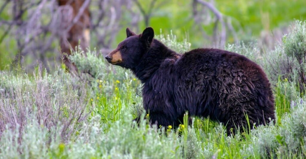
Black bears and other wildlife that might be spotted on the trail will usually leave you alone if you do the same for them and respect their space.
©iStock.com/christiannafzger
There’s nothing quite like moving at the pedaling pace and taking in the sights and sounds of nature. While some wildlife encounters are a special treat, others require incredible caution. Awareness of your surroundings and respecting the space of any wildlife you encounter are important practices while on the trail.
While there are no brown or grizzly bears in Oregon, you might spot a black bear. They’ll leave you alone if you do the same for them. Be sure not to get between a mamma bear and her cubs. Mountain lions are curious but elusive creatures that also prefer to leave you alone. If you encounter either of these predators while on the trail, do not run. Instead, make yourself appear as large as possible and yell firmly and loudly.
To prevent raccoons, squirrels, and others from pilfering through your food stashes, make sure they are packed away carefully. Mosquito repellent is a great idea, as they are voracious feeders in the high country that are at their peak as soon as the snow melts and continue to feed throughout the season.
The photo featured at the top of this post is © Michal Balada/Shutterstock.com


How to Add Us to Google News


Thank you for reading! Have some feedback for us? Contact the AZ Animals editorial team.