
Riding your motorbike is one excellent way to enjoy nature. If you’re seeking a new activity or simply want to go outside more, there are a lot of great bike routes for all levels of ability in Texas. With warm winter weather and many terrains, whether rural, urban, or anywhere in between, the Lone Star State is an excellent destination to ride your bike.
In this article, we’ll look at the longest biking trail in the state. We’ll also cover everything you need to know about the trail, including a section on the Trail.
Let’s begin!
The Longest Biking Trail in Texas: Northeast Texas Trail
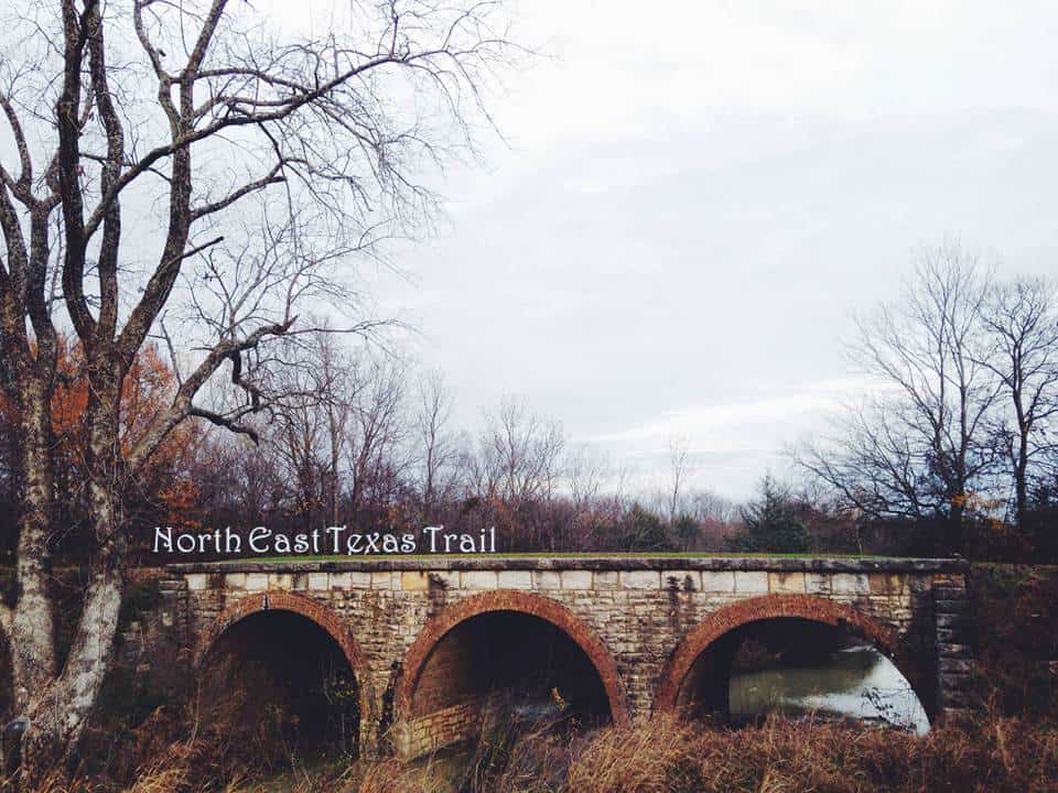
The Northeast Texas Trail stretches 130 miles through the fields and woodlands of 7 counties.
The Northeast Texas Trail (NETT) stretches 130 miles through the fields and woodlands of 7 counties. It will be the state’s longest bike trail and the fifth-longest bike trail in the United States once finished, though the exact date is unknown. Hikers, mountain bikers, and horse riders will all be able to use the trail. Also, trailheads will be located throughout the path’s route, and the trail will stretch into more rural areas between cities. However, bikers, hikers, and horseback riders who want to see it today don’t have to wait as long as they don’t mind some rough sections. As a matter of fact, in such lush terrain where abandoned trails vanish into the wilderness, every step and every bike stroke is a vote for the trail’s continuation.
History
The first train rails in Northeast Texas were erected about 150 years ago, but they stopped being used around the 1990s. Instead of giving up the routes and losing their right-of-way easements, the Chaparral and Union Pacific railroads consented to a judicial process known as railbanking, which permits the lines to be used as trails until they are eventually required for rail service. The two parties suspended active service and announced the availability of their railroad routes for railbanking through the Surface Transportation Board of the US Department of Transportation. In response to the move, three private organizations, the Greater Paris Development Foundation, Rails to Trails Conservancy, and Chaparral to Trails Inc., applied for and received trail bank status.
In 2012, the Northeast Texas Trail Coalition became a 501(c)(3) organization and was given operational control of the NETT. Various towns and cities along the path have assumed responsibility for the trail. More localities have been granted trail bank status on other sections of the neglected railway.
The Trail unites numerous northeast Texas cities and counties and offers a primary recreational resource for the more than 47,500 individuals living and working within a mile of it. People who live in Texas and those who are just visiting flock to the new, partially built route.
Description
The NETT begins in Farmersville, about an hour northeast of Dallas, and finishes 8 miles from the Arkansas border on the Red River at New Boston. Or does it begin in New Boston and terminate in Farmersville? Well, both towns have been known to claim trailhead status. The trail spans seven counties and links 19 cities, and there are almost 100 rail crossings and multiple waterways. Farmersville has a rail connection embedded in the ground to represent mile zero. The trail is paved for the first two and a half miles, after which there are shattered stone, dirt, and gravel surfaces. Some parts of the trail are paved like it is in Farmersville, others are plowed and trimmed, and the majority is rocky terrain. While certain path sections are still under construction, hundreds of enthusiasts have already discovered several miles of fun.
With a population of over 25,000, Paris is a larger city than many of the little towns along the trail. The Chaparral Rail Trail is the segment of the NETT that runs to this point, while the Trail de Paris Rail Trail is the section that runs into Paris. The majority of this segment is covered with a painted center stripe. There are greeting markers at eight trail entry spots with parking spots nearby. There are seats available for relaxing along the way, as there are on other parts of the trail. There’s also a little butterfly garden and a lovely corridor with numerous crepe myrtle species.
Except for a short stretch in New Boston towards the end, the last 22 miles of the Northeast Texas Trail run alongside Highway 82 and are unpaved. New Boston has a big trailhead with parking near North Elm Street and Southeast Front Street.
Using the Trail
The trail is notable for a variety of reasons, whether you’re biking or hiking. In order to get fit, some people go on a hiking trip, while others prefer to go on a nature walk because they enjoy the scenery.
The NETT website has a color-coded map for trail users. It shows the distance between towns and places suitable for hiking, biking, and horseback riding. Some areas are ideal for hiking only, so bikes and horses are not permitted. The map depicts all the bridges, culverts, obstructions, and hazards such as fences and biting dogs.
For those who want to travel great distances, accommodation, food, and campgrounds are available along the way. Nonetheless, you should plan your visit beforehand.
Northeast Texas Trail Coalition
The Northeast Texas Trail Coalition, a nonprofit collaboration of local and national trail activists and government entities, now oversees the property owned by Union Pacific and Chaparral railroads. It collaborates with local governments, nonprofit land trusts, and volunteer groups in all 7 Northeast Texas counties to preserve and protect the Northeast Texas Trail, as well as to plan, build, and popularize it.
During the last few years, the coalition has received federal and state subsidies to grade, pave, and lay crushed granite along sections of the NETT, rebuild some of the ancient bridges, install signboards and handrails, and much more. The trail lovers collaborated with the City of Blossom, the City of Reno, Lamar County, and three times with the City of Paris to write the proposal and be given Texas Parks and Wildlife’s (TPWD) Texas Recreational Trails Fund funds for 5 of the 7 expansions. Clarksville, Farmersville, and New Boston have all obtained TPWD funds to build trails along their respective sections of the NETT route.
On its website, the NETT Coalition provides an interactive map with details on food, housing, and campsites near the route, as well as risks to avoid, such as the occasionally broken bridge and the existence of hostile dogs, which are a concern for bikers and pedestrians. The council meets twice a year, alternating between cities along the trail and those who support it.
Where Is the Northeast Texas Trail Located on a Map?
The Northeast Texas Trail runs between Farmersville and New Boston, Texas, alongside US Highway 82 and Texas Highway 34. When complete, the trail will connect 19 towns on a line between Dallas/Ft. Worth and Texarkana. It crosses a number of streams including the Sulphur River and Kickapoo Creek.
The photo featured at the top of this post is © Hadlock / Creative Commons / Original


How to Add Us to Google News


Thank you for reading! Have some feedback for us? Contact the AZ Animals editorial team.