
A nature walk can sometimes be the best therapy. Whether it’s a trek in the woods, a day in the mountains, or a morning walk along the ocean, heading out for a hike provides many advantages that promote a healthy mind, body, and soul. And whether you want to get out into the woods or get away from the hustle and bustle of city life, only a few places are better than California. It is a large state with lots of exciting sites to explore, from magnificent beaches to picturesque islands to a plethora of national parks.
While there are a seemingly limitless number of fantastic hiking spots around the country, no landmass offers greater variety in terms of landscape types, biodiversity, and climate than California. This article, however, will look at the longest hiking trail in California. It’ll cover everything you need to know about the trail, including how to get on the trail, things to expect on the trail, and when to start your hike.
The Longest Hiking Trail in California: Pacific Crest Trail
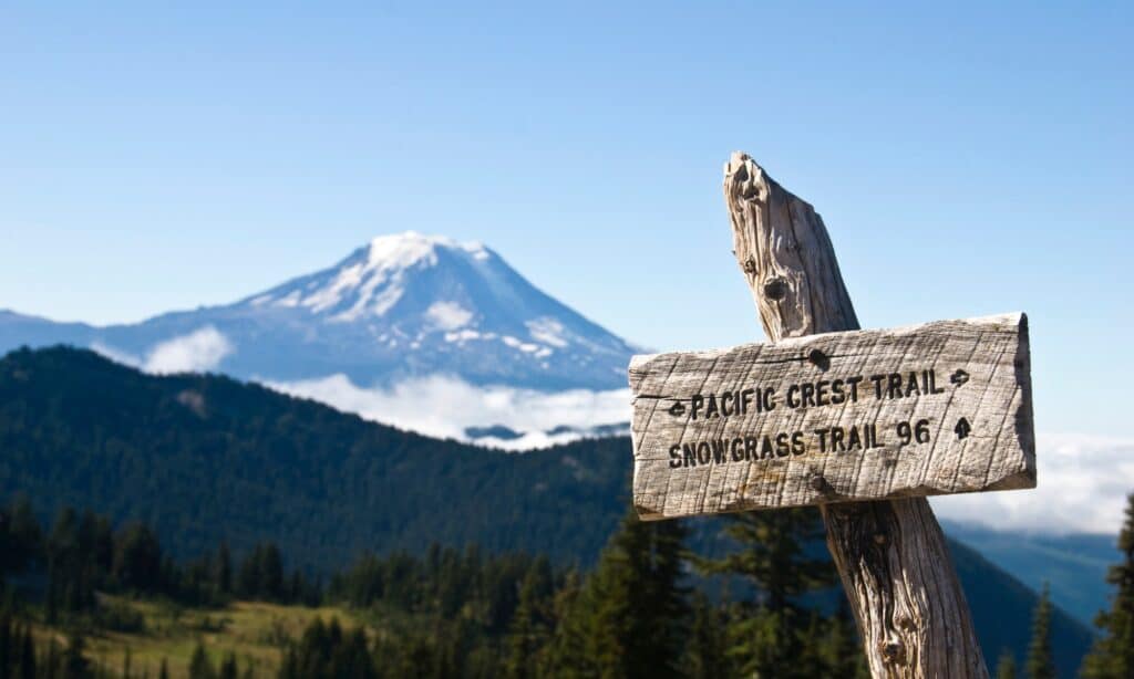
The Pacific Crest Trail is the longest hiking trail in California.
©iStock.com/RobertCrum
Dubbed one of the most fascinating hiking trails in the world, the Pacific Crest Trail (PCT) is not just about its altitude. The nearly 2700 miles of beauty was declared a National Scenic Trail in 1968, spanning from the US/Mexico border to just beyond the US/Canada border. This makes it the second-longest hiking trail in the United States. Many sections of the trail are utilized for horseback riding and shorter treks, but skilled hikers can travel the route in its entirety.
Pacific Crest Trail is known for delivering a demanding but breathtaking array of wilderness from dense forest to desert, sun-speckled, glacier-fed streams to the snow-capped mountains. Exploring any stretch of the PCT, either for a few miles or a season, will be an event you won’t forget throughout your life.
History
In 1932, the Pacific Crest Trail System Conference, an association of hiking associations and youth groups led by hiking fanatic Clinton C. Clarke, officially brought up the idea of a border-to-border trail and spent years working to gain support for it. With the enactment of the National Trails Act in 1968, Congress approved the Pacific Crest National Scenic Trail, and an independent panel was formed to create the trail and a management plan. In 1972, the route was decided, and in 1993, it was accomplished. The Pacific Crest Trail Association, a nonprofit trail activist group, works in partnership with the US Forest Service and other federal organizations to maintain and run the trail.
Description
Officially known as the Pacific Crest National Scenic Trail, the Pacific Crest Track is a wilderness pathway and horse trail in the western United States. It stretches 2,653 miles from the Canadian border close to Castle Peak, northern Washington, to the Mexican border around Campo, California, from north to southeast. The path traverses through 7 national parks, 12 wilderness areas, and 25 national forests as it follows the crests of the Sierra Nevada and Cascade mountains through Washington, Oregon, and California.
The Pacific Crest Trail provides views of Mounts Whitney, Hood, Shasta, Rainier, and others. The path offers significant natural diversity from north to south, with five individual sections featuring diverse plants, animals, climates, and topography. Forester Pass, close to Mount Whitney, is its highest point. The Canadian government extended the trail into Manning Provincial Park by adding a 7-mile section in British Columbia.
Most parts of the southernmost regions are filled with desert scrubs, including rich fir, cedar, hemlock, larch, and ponderosa pine forests. Coyotes, deer, black bears, elk, foxes, raccoons, marmots, and grouse can all be found along the path. The road through Washington is typically wet, resulting in hundreds of tiny glaciers and snowfields. The trail passes through the national parks of the North Cascades and Mount Rainier. It also goes through the Columbia River Gorge National Scenic Area and into Oregon, where it travels through lush fir forests, lakes, and volcanoes before passing through Crater Lake National Park.
The PCT follows the highly wooded logging country of northern California and Lassen Volcanic National Park. It traverses through mountain ranges, meadows, and cone-bearing woods in central California, as well as Kings Canyon, Sequoia, and Yosemite national parks and Devils Postpile National Monument. The trail crosses the Mojave Desert and the San Andreas Fault zone in southern California, passing close to the cities of San Bernardino and Palm Springs.
How to get to the Pacific Crest Trail
There are many international airports within easy driving distance of the route.
©iStock.com/UT07
Many international airports are within easy driving distance of the route. San Diego is closest to the Mexican border and serves as the southern terminus for northbound hikers, while Seattle serves as the northern terminus for southbound hikers. There are also other international airports, such as the Vancouver airport in Canada and the Tijuana airport in Mexico. The cities of Los Angeles, San Francisco, and Portland can also be reached through areas close to the city borders. Other smaller and less popular areas also have connections with the trail.
Things to expect on the Pacific Crest Trail
During the day, the desert might be scorchingly hot, but at night, it can be frigid.
©iStock.com/Bill Kingman
On the path, the terrain and environment fluctuate as much as the height. At an elevation of 9000 feet, it can be 90 degrees in the blistering desert sun one day and almost freezing the next. It’s critical to plan for every day or even hourly fluctuations. The trail’s lowest point is the Columbia River Gorge on the border of Oregon and Washington, which is only 170 feet above sea level. The Forester Pass in California’s Sierra Nevada range is the highest point, standing at 13,200 feet. You could develop altitude sickness in the morning and dehydration in the afternoon due to the large variation.
Another factor to consider is the weather, which can sometimes be unpredictable. During the day, the desert might be scorchingly hot, but at night, it can be frigid. Temperatures can shift from almost 90 degrees to freezing in the Sierra Nevada and Cascades, with snow even in the summer. The variety can be thrilling, but regardless of the weather channel, expect rain, snow, lightning, sleet, hail, and everything in between at any point along the trail, any time of the year.
When to Start Your Hike
Timing is essential whether you’re traveling from south to north, which is the most common, or from north to south. For individuals hiking towards the north, starting times span from March to late May or June. If you’re traveling south, the start dates will be determined by the snowpack in Washington’s North Cascades, but they can vary from early June to September, with their own set of restrictions. You must, however, obtain a permit from the Pacific Crest Trail Association before beginning your journey on the trail.
Where Is the Pacific Crest Trail Located on a Map?
The photo featured at the top of this post is © iStock.com/RobertCrum


How to Add Us to Google News


Thank you for reading! Have some feedback for us? Contact the AZ Animals editorial team.