
The steepest road in Texas, Farm to Market Road, is also called Route 170, or FM 170. It is also known as River Road. FM 170 starts in Candelaria, passing through the city of Presidio, former settlements, and smaller communities before reaching State Highway 118 (SH 118). The road also winds through the southern part of Big Bend Ranch State Park. It ends near Big Bend National Park in Study Buttle at SH 118.
A road trip via FM 170 truly offers a dizzying adventure through the desert backyards of South Texas. You’ll maneuver twists and bends as you climb mountains and traverse valleys with fantastic scenic views.
The steepest road in Texas has a long history. It was first paved in 1945 in Presidio County, covering fewer miles. Extensions and new designations over the years have increased its length to 114.58 miles traversing over two Texas counties, Brewster and Presidio.
Where Is the FM 170?
FM 170 is in Texas along the international border of the United States and Mexico. The 114.6-mile highway is in West Texas and slinks through the Chihuahuan Desert along the valley of the Rio Grande River.
The Farm to Market 170 Highway starts in Candelaria, about 48 miles north of Presidio. FM 170 is the only road connecting the remote community to Presidio.
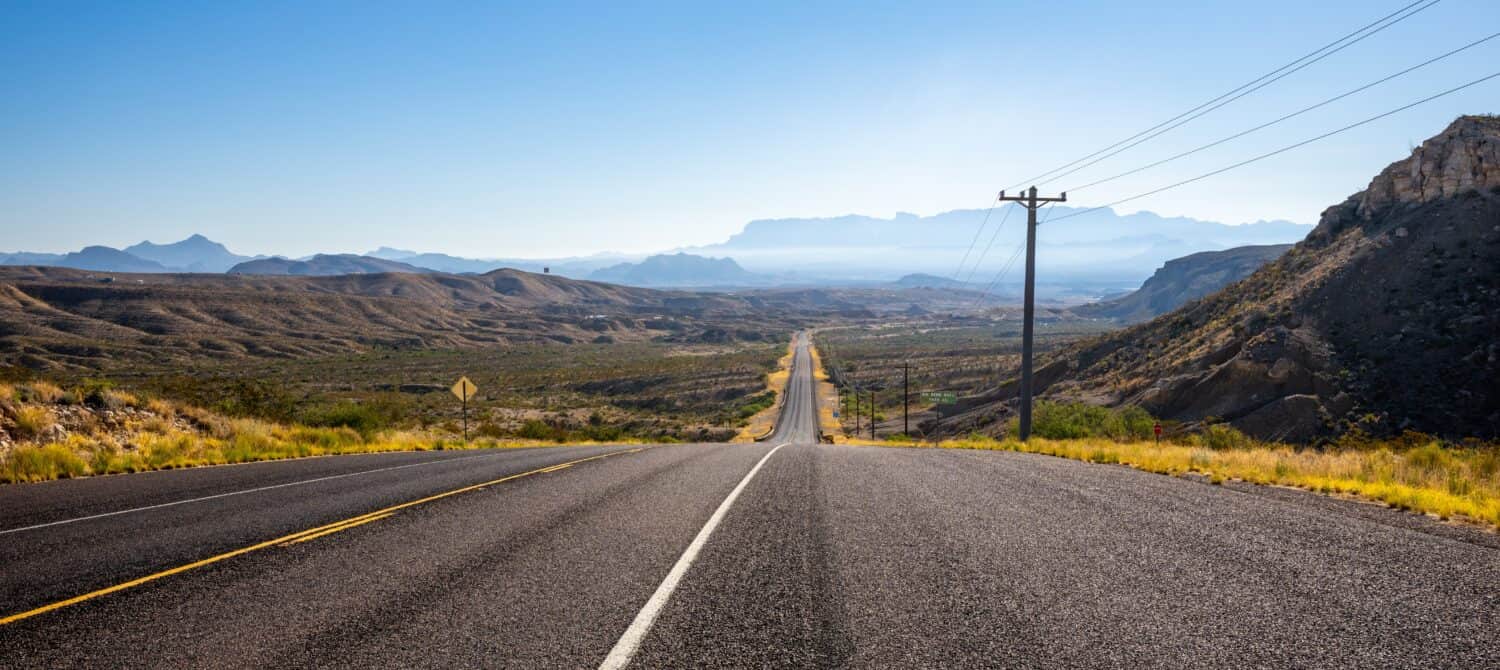
Farm to Market 170 is the steepest road in Texas.
©Rosemarie Mosteller/Shutterstock.com
On its course, the highway stretches through the Big Bend State Ranch Park and some ghost towns inhabited long ago. The road heads to Terlingua via Redford and terminates at SH 118 in Study Buttle, where a different highway leads to Big Bend National Park.
Driving on this steepest road in Texas is an adventure, with captivating scenes. FM 170 offers views of plants, wildlife, terrains, mountains, and the Rio Grande.
Major Intersection on FM 170
FM 170 has six significant intersections. Five are in Presidio County, and the last is at its termination at Study Buttle in Brewster County. The first intersection is at the start of the road in Candelaria, where FM 170 joins with Chispa Rd. After 47.8 miles, the road intersects US 67 and heads north to Marfa. Half a mile further is the third intersection, with US 67 heading to Ojinaga.
The fourth intersection is just a mere 0.4 miles from the previous US 67 to Ojinaga. It intersects with Spur 203 (Erma Avenue). The last junction within Presidio County is 49.3 miles from Candelaria, connecting with Bus US 67.
What Is the Max Grade of the FM 170 Highway?
The Farm to Market Road 170 is a state-maintained two-lane highway. It starts near Big Bend National Park in Study Butte, heading towards the Rio Grande at Lajitas. The road then heads northwest towards Presidio parallel to the Rio Grande River. The section from Terlingua to Presidio is a paved highway.
From Presidio, it continues northwest and heads north to the settlement of Candelaria. The 48-mile stretch to the north before reaching Candelaria is only navigable using a 4wd vehicle with high clearance. From Candelaria, FM 170 ends at Chispa Road as an unpaved, rugged pathway. The road also interconnects with US 90 and I-10 via remote ranching and farming roads.
History of the Steepest Road in Texas
Although most sections of the road lack settlements, it passes some historical sites of interest. But the steepest road in Texas has a long history since it started in 1945 at just five miles long. Continued additions and renaming existing streets contributed to its current length.
Here is a summary of the milestone Minute Orders shaping the current FM 170 road.
Minute Order 021215, June 11, 1945
June 11, 1945, is the first date of agreement. Minute Order 021215 designated a distance of five miles in Presidio County, from US 67 toward Ochoa as Farm to Market Road No. 170.
Minute Order 026099, December 16, 1948
The Minute Order extended the FM 170 road in either direction within Presidio County, with the most extensive expansion occurring in the northwest by adding 13.9 miles toward Adobes. To the southeast, six miles of paving extended the road to Alamito Creek. In addition to the five miles, FM 170 reached 25.2 miles.
Minute Order 027145, July 15, 1949
July 15, 1949, Minute Order extended the road to the southeast by 11.7 miles to reach Redford in Presidio County. FM 170 from US 67 to Adobes had approximately 18.9 miles at the time of addition. The extra 11.7 miles toward Redford increased the southeastward section to 18 miles. In total, the road now covered a distance of 36.9 miles.
FM 170: Minute Order 035165, October 29, 1953
The Order extended the FM 170 road 10.8 miles within Presidio County towards the northwest to reach Pinto Canyon. The extension pushed the road distance northwestward from Presidio to 29.3 miles. The entire road covered a total length of 45.5 miles.
FM 170: Minute Order 038482, July 28, 1955
Minute Order 038482 through Administrative Circular, dated September 15, 1955, commissioned an extension from Redford about five miles long southeastward. The road then reached a distance of 21.4 miles heading southeast from Presidio via Redford.
In addition to the 29 miles northwest from US 67 at Presidio to Pinto Canyon, it covered 50.4 miles in Presidio County. The Circular also changed FM 170 to Ranch to Market (Route 170), giving it a new description.
FM 170: Minute Order 045056, October 31, 1958
The Order commissioned further extension southeastward, approximately 12 miles via Redford within Presidio County. From Presidio, precisely a point on US 67 heading southeast via Redford, RM 170 reached about 33.1 miles. In addition to the section heading northwest from Presidio to Pinto Canyon, the road had a combined distance of approximately 62.1 miles.
FM 170: Minute Order 047184, February 05, 1960
It was created to the southeast, approximately 19.0 miles up to the end of RM 2462. The Order also canceled FM 2462 and combined the RM 170, adding another 19 miles to the road. In total, RM 170 covered a distance of 98.7 miles. The route extended from SH 118 to the west via Terlingua and northwestward from US 67 at Presidio via Redford, traversing Brewster and Presidio Counties.
FM 170: Minute Order 059598, June 02, 1967
It added roughly eight miles through a new addition toward northwest reaching Ruidosa. Now, FM 170 road ran 104.1 miles, joining three sections—SH 118 to Terlingua, Redford to US 67 at Presidio, and the northwestward section to Ruidoso.
FM 170: Minute Order 078958, October 21, 1981
The 1981 Order added 11.6 miles extending northward via Ruidosa to Candelaria. The road reached approximately 114.6 miles by renaming and joining an existing highway.
FM 170: Minute Order 106870, June 18, 1996
This most recent Order shaped the FM 170. At District’s request, FM 170, US 67, and BU 67A through Presidio were joined to complete routing across the two counties.
Is There Wildlife Along the Steepest Road in Texas?
Although one may think no vertebrates live in the Chihuahuan Desert, some animals still call it home. In fact, the Chihuahuan Desert is the most ecologically diverse dry region in the Western Hemisphere. The diversity of Big Bend National Park and The Big Bend State Ranch Park is unique.
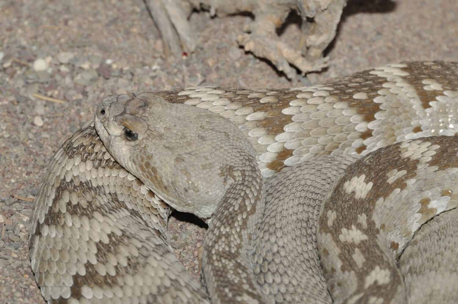
You can find
rattlesnakes
in the Chihuahuan Desert along FM 170.
©Mike Treglia/Shutterstock.com
The region is composed of different terrains, including:
- Acres of Chihuahuan Deserts
- 100 miles of the river valley
- Oases
- Mountain elevations
- Grasslands
- Shrubs
The varied ecosystems within Big Bend are home to more than 75 species of mammals, 450 species of birds, 56 species of reptiles, 10 species of amphibians, and dozens of insects.
The Rio Grande is the primary water source and is home to several species of beavers, turtles, and waterfowl. Forty species of fish thrive in Rio Grande waters.
The channeling of the river for irrigation through Rio Grande Village to Cottonwood Campground contributes to the flourishing of sycamore, cottonwood, and ash in the irrigated areas. Expanding the river corridor beyond its natural course is an advantage to wildlife. Animals can now source water and food from vast places, including irrigated lands.
Many resident animals adapted to survive in the hot and dry setting of the Chihuahuan Desert. However, most go unnoticed since many animals are nocturnal and prefer calmer, less severe night conditions.
Nocturnal Chihuahuan Desert Wildlife
- Kit fox
- Bobcat
- Ringtail
- Kangaroo rat
- Bats
Some animals like badgers, desert cottontails, blacktail jackrabbits, and mule deer may be spotted at dusk or early morning. Also roaming in the park are mountain lions, javelina (collared peccary), and an occasional black bear
Reptiles roaming the desert include the bull snake, coachwhip, diamondback rattlesnake, southwestern earless lizard, checkered whiptail, and the southern prairie lizard. Desert centipedes and scorpions hunt during the night and rarely come out when the sun is up.
Points of Interest Along FM 170?
The scenic views along River Road through the Big Bend Ranch State Park are lovely. The steepest road in Texas also navigates through towns, settlements, ghost towns, historical sites, and a golf resort and connects to Big Bend National Park.
Here is a look at some points of interest accessible via the FM 170 road:
Barton Warnock Environmental Education Center
The bookstore is at the eastern entry of the Big Bend Ranch State Park. They have well-chosen materials covering the area’s history and geology. Warnock Center is also an excellent place to acquire permits and updated area maps.
The park and bookstore staff are an excellent source of the best spots for hiking and trail conditions. Folks have access to official information from the locals (a source of information that is very vital). You can also stroll on their two-acre desert farm to familiarize yourself with the desert flora.
Fort Leaton State Historic Site
The fort is not very far from Presidio. It was popular in the 1800s for travelers’ goods and provided security against outlaws. The site is part of the Big Bend Ranch State Park and has a small museum.
Lajitas Golf Resort
Lajitas is a golf resort town on your way to Terlingua from Presidio, about 50 miles bordering Big Bend Ranch State Park. There is an airport in the city that only offers private services. It boasts some of the best accommodations along the Farm to Market Road 170.
Terlingua
This artist community hosts a famous chili contest annually.
Big Bend National Park
Past Terlingua, you will reach the end of FM 170. The junction to the left takes you to Alpine, and the right takes you to Big Bend National Park. The park offers a wide variety of desert landscapes and wildlife.
The Big Hill
Between Terlingua and Presidio are signs for the Big Hill, a prominent vantage point overlooking Mexico, the Santana Basin, and the Rio Grande north extension.
Marfa
Marfa is a major tourist destination because of its gallery of minimalist art. Besides art, Marfa has historical army sites and the German Prison of War used during World War II.
Building 98, a former war prison, houses the German POW paintings. The murals were completed in 1945 by Robert Humpel and Hans Jurgen Press, who were POWs in the camp.
Nine miles away, as you head to Alpine, is the official viewing point for the Marfa Lights. The viewpoint is built at the entrance of an abandoned army airfield. The lights move, changing colors and intensity. Marfa Lights were first reported in 1883 and are a source of over 75 local folk tales.
Ghost Towns
The 36-mile stretch of FM 170 from Marfa to Presidio passes through ghost towns, former communities that thrived with people. However, these ghost towns today are either abandoned or very few people live there. Four former communities between Marfa and Presidio are:
- Adobes
- Chinati
- Indio
- Ochoa
Historic Adobe Catholic church
The Sacred Heart Mission church ruins are found along the Candelaria-to-Ruidosa section of the FM 170.
Farm to Market (Route 170) Summary
FM 170 is the steepest road in Texas, offering a dizzying adventure. You will need an off-road vehicle with ample clearance to drive along many of its trails. The drive from Presidio along the Rio Grande to SH 118 at Subtle is paved, except for portions that venture to connecting rural routes.
Ensure you have a full tank, and your car is in good condition. Gas stations are far apart, and breaking down in some remote places is dangerous because cell phone reception is weak. Carry snacks and enjoy the designated picnic site along the route.
The photo featured at the top of this post is © G B Hart/Shutterstock.com


How to Add Us to Google News


Thank you for reading! Have some feedback for us? Contact the AZ Animals editorial team.