
A tsunami is an enormous wave caused by a disturbance in the ocean. The most common type of disturbance is an earthquake, but it can also be caused by volcanoes or even by humans. Earthquakes occur when two plates of the earth’s crust move suddenly and violently against each other.
This can happen when one plate slides underneath the other or when two plates collide head-on. When this happens, the water above the disturbance is displaced, creating a wave. If the wave is large enough, it can generate a tsunami. When a volcano erupts, it can displace a large volume of water and create a tsunami.
Finally, humans can also cause tsunamis. This is most commonly done by detonating explosives underwater. The explosion creates a wave that can become a tsunami if it is large enough. If they are large enough, tsunamis can cause extensive damage to coastal areas and even inland areas. So, what are the worst tsunamis, and what caused them? Let’s find out.
Vajont Dam, Italy — Megatsunomi
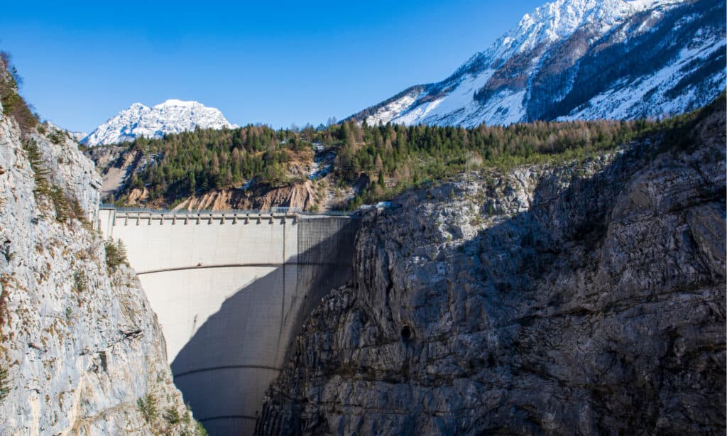
A landslide occurred during the initial filling of the lake in 1963, causing a landslide which lead to a megatsunami.
©Devis_Sole/Shutterstock.com
Northern Italy is home to the Vajont Dam. This is one of the world’s tallest dams, standing at 860 feet. It’s in the Vajont River valley beneath Monte Toc, in the town of Erto e Casso, 62 miles north of Venice. The dam was designed in the 1920s and ultimately constructed between 1957 and 1960 by Società Adriatica di Elettricità (SADE).
During the initial filling of the lake on October 9, 1963, a landslide caused a megatsunami that sent 50 million cubic meters of water over the dam in a wave that was 820 feet high. This caused massive flooding and destruction in the Piave Valley below, destroying several villages and towns and killing an estimated 1,900 to 2,500 people. Almost all of the dam stayed in place, and two-thirds of the water was kept behind it.
This occurred due to reports and evidence that Monte Toc, on the southern side of the basin, was geologically unstable, being withheld and disregarded by ENEL Green Power (ENEL) and the Italian government. They had ignored numerous cautionary signals, red flags, and negative press. Because ENEL was unaware of the size of the landslide, they attempted to safely halt it just as the disaster was about to strike by lowering the lake’s level.
Lituya Bay, Alaska — Megatsunomi
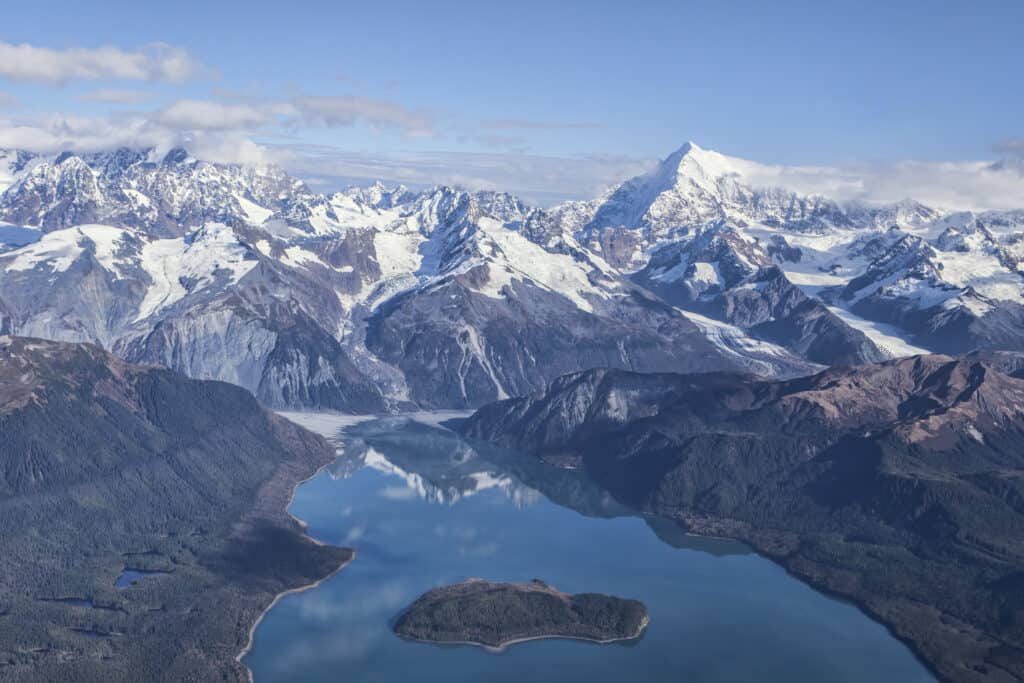
The 1958 megatsunami in Lituya Bay, Alaska was the tallest ever reported with a height of 1,720 feet.
©iStock.com/mscornelius
In 1958, following the earthquake in Lituya Bay, Alaska, a tsunami with a reported height of 1,720 feet, the tallest ever recorded, occurred. The tsunami claimed the lives of five people, injured many others, and destroyed many homes. As a result of being caught in a wave in the bay, two fishermen perished. A fishing boat captain and his son, who was seven years old, were struck by the wave and launched hundreds of feet into the air.
Surprisingly, neither was seriously hurt, and both survived. Yakutat was the only permanent outpost at the time that was close and experienced damage to its bridges, docks, and oil lines. A cabin sustained irreparable damage when a wave tower collapsed. The Alaska Communication System’s underwater cables were severed. There were sand boils and fissures close to the coast southeast of there.
The cities of Sitka and Pelican also sustained minor harm. It destroyed the forest surrounding the shoreline and left the high tide line barren, with only a few upright surviving trees on the northern and southern edges. It tore limbs from trees and swept many of them away. The megatsunami flooded the entire bay and left a 700-foot-long damage line around its perimeter. It is still discernible from space today.
Krakatoa 1883
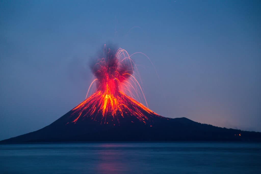
The eruption of Krakatoa volcano between Java and Sumatra in Indonesia 1883 was heard 3,000 miles away.
©Deni_Sugandi/Shutterstock.com
Krakatoa’s 1883 eruption in the Sunda Strait between Java and Sumatra reached a climax in the early hours of August 27, when it destroyed more than 70% of the island and its surrounding archipelago as it collapsed into a caldera. The eruption lasted from May 20th to October 21st, 1883. The eruption was one of the deadliest and most destructive volcanic events in recorded history.
The explosion was heard 1,930 miles away in Perth, Western Australia, and 3,000 miles away in Rodrigues, near Mauritius. According to reports, the sound was audible in fifty countries worldwide, and the sound wave traveled seven times worldwide. The eruption and the tsunamis that resulted are thought to have killed at least 36,417 people. Significant additional effects were felt all over the world in the days and weeks following the volcano’s eruption.
Tsunamis shook ships as far as South Africa. Victims’ bodies were discovered floating in the ocean for months after the incident. Each of the great explosions accompanied by sizable pyroclastic flows resulted from the gravitational collapse of the eruption columns. This is thought to have caused the tsunamis that accompanied the eruption. This displaced an equal volume of seawater as several cubic kilometers of material entered the ocean. A tsunami over 150 feet tall destroyed the town of Merak.
Tōhoku Earthquake and Tsunami
The Tōhoku earthquake caused a tsunami with waves as high as 133 feet.
©mTaira/Shutterstock.com
Tōhoku Earthquake in 2011 was the strongest earthquake measured in Japan, and it sent powerful tsunami waves hurtling toward Miyako that may have reached heights of up to 133 feet. It traveled up to 6 miles inland and 435 mph in the Sendai region. Only eight to ten minutes of warning were given to Sendai residents, and more than a hundred evacuation points were destroyed. Rescue efforts were significantly hampered by the tsunami’s snowfall and freezing temperatures.
Reports from 2015 showed 228,863 people were still living away from their homes in either temporary housing or due to permanent relocation. The official statistics released in 2021 reported 19,747 deaths, 6,242 injuries, and 2,556 people missing. The meltdowns of the reactors located at Fukushima Daiichi, the release of radioactive water into Fukushima, and the associated evacuation zones that affected hundreds of thousands of residents were all brought on by the tsunami.
The nuclear power plant was damaged by the strong tsunami that the earthquake caused, which had waves that were 13 to 14 meters high. The outcome was the most severe nuclear accident since the Chernobyl disaster in 1986, which was later given a level seven classification on the International Nuclear Event Scale (INES) after initially being given a level five rating. Chernobyl is the only other accident to have received this classification.
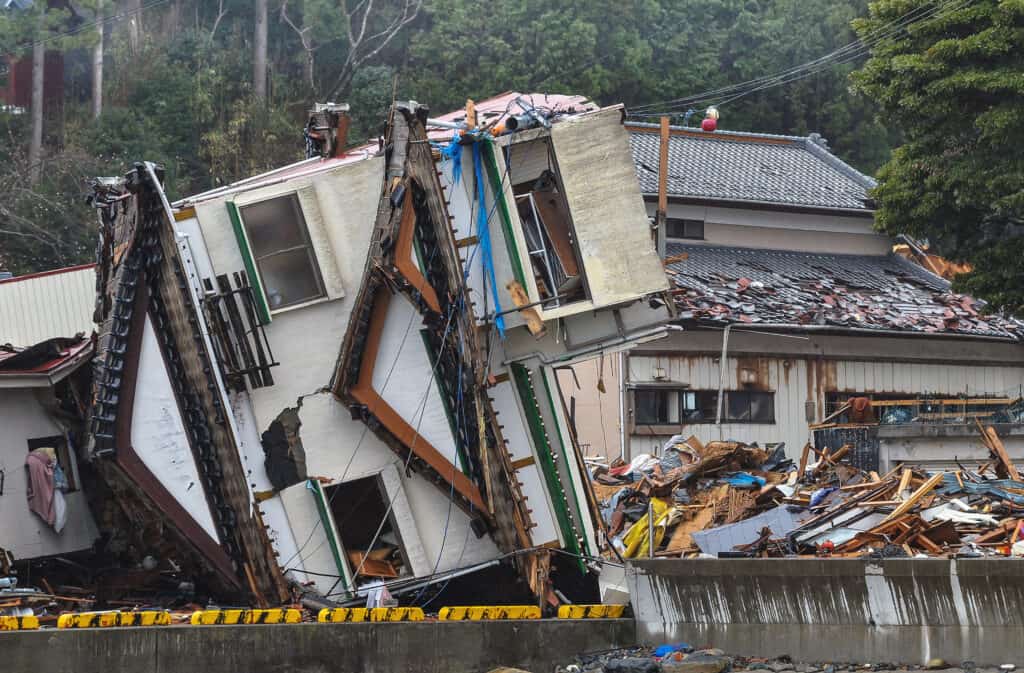
Indian Ocean Earthquake and Tsunami
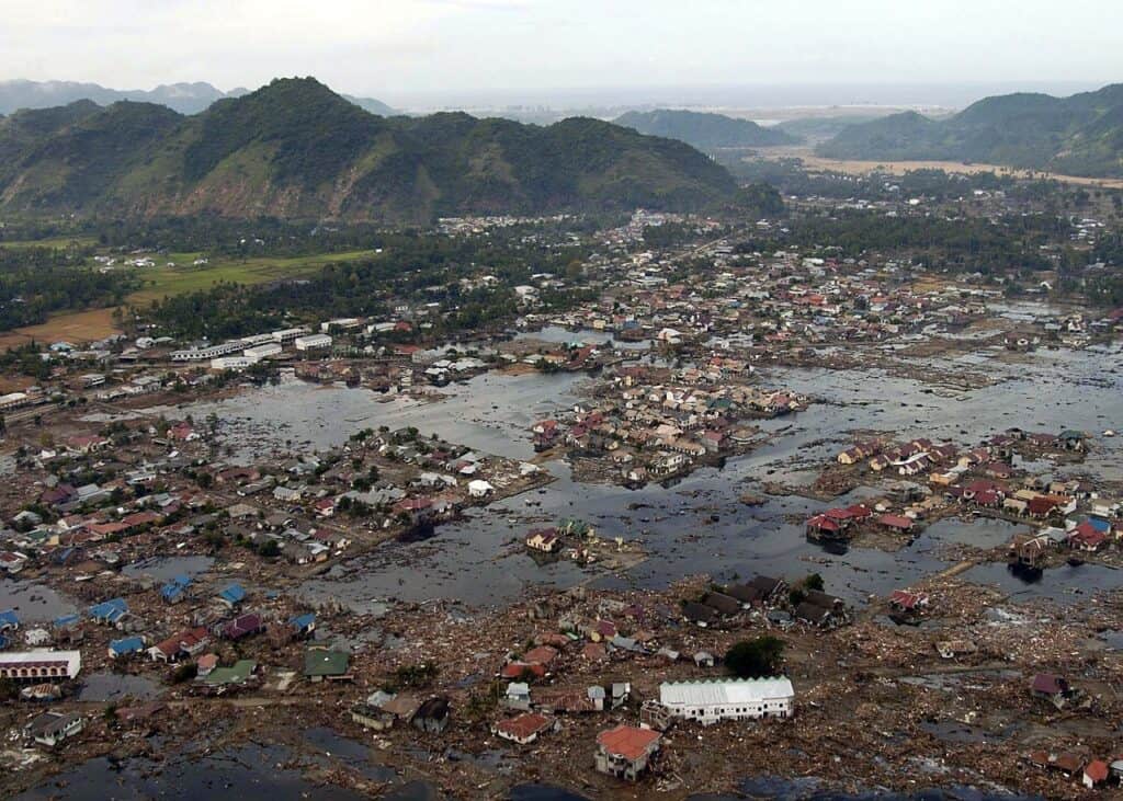
Devastation to a village near Sumatra from the 2004 Indian Ocean tsunami
©U.S. Navy photo by Photographer’s Mate 2nd Class Philip A. McDaniel / public domain
During the 2004 earthquake, the seabed suddenly rose several meters, which moved vast amounts of water. This caused a tsunami that hit the coasts of the Indian Ocean. Sometimes, a tsunami that causes damage far from where it started is called a teletsunami. It is much more likely to be caused by the seabed’s vertical movement than by the seafloor’s horizontal movement.
This tsunami behaved differently in deep water as all tsunamis do. Tsunami waves form a low, broad hump in deep ocean water that is barely perceptible and harmless and moves at 310 to 620 mph. A tsunami only slows to tens of kilometers per hour in shallow water close to coastlines, but it still creates massively destructive waves.
Scientists looking into the damage in Aceh, Indonesia discovered evidence that the wave was 80 feet tall when it hit the shore and 100 feet inland. Due to distance, the tsunami took between 15 minutes and 7 hours to reach the coast. Sri Lanka and India’s east coast were struck 90 to 120 minutes after northern Sumatra. Due to the shallow Andaman Sea off its western coast, Thailand was hit two hours later despite being closer to the epicenter.
Up Next:
- What Is The Eye Of A Hurricane And Why Does It Form?
- What Causes Hurricanes? How are They Formed?
- Why Do Hurricanes Have Names, and How Are They Chosen?
The photo featured at the top of this post is © Michael Vi/Shutterstock.com


Sources
- Australian Geographi, Available here: https://www.australiangeographic.com.au/topics/science-environment/2011/03/the-10-most-destructive-tsunamis-in-history/
- Ocean Info, Available here: https://oceaninfo.com/list/worst-tsunamis-in-history/
- Borgen Project, Available here: https://borgenproject.org/5-worst-tsunamis/
- World Atlas, Available here: https://www.worldatlas.com/articles/deadliest-tsunamis-since-1900.html
How to Add Us to Google News


FAQs (Frequently Asked Questions)
Do tsunamis hit the United States?
There have been significant tsunamis in the United States, and more will undoubtedly happen. Tsunamis that impacted Hawaii, Alaska and the west coast of the United States were caused by significant earthquakes along the Pacific rim.
How many tsunamis hit the United States, and which was the worst?
The 1946 Alaska tsunami was the deadliest to strike the United States, killing 165 people.
Thank you for reading! Have some feedback for us? Contact the AZ Animals editorial team.