
What comes to mind when you think about earthquakes? Collapsed buildings, landslides, power outages, or flash floods? True, these and more are the forms of damage that can be caused by earthquakes.
However, earthquakes aren’t always associated with severe consequences. Hundreds of earthquakes are said to take place on Earth every day. Most of them are hardly noticeable to a lot of people though. A significantly larger earthquake does, however, occasionally strike. More often than once a month, a big earthquake of magnitude 7.0 to 7.9 occurs somewhere around the world. A massive earthquake—one with a magnitude of 8.0—or higher hits about once a year.
Anywhere can experience an earthquake, but the bulk of earthquakes occur along the boundaries of tectonic plates. Tectonic plates, which are located beneath the planet’s landmass and oceans, make up the Earth’s surface.
Mountains may form or volcanoes may erupt as a result of these plate motions. The collision of tectonic plates can also result in strong earthquakes, which cause the Earth’s surface to shake. Some places are more prone to experiencing earthquakes than others. For instance, California is located on top of a fault line where two plates meet. No doubt, the effects of an earthquake caused by the collision of plates can be disastrous and catastrophic.
According to the Insurance Information Institute, the Northridge earthquake in 1994 and the 6.9 magnitude Loma Prieta earthquake in 1989, which devastated the Oakland-San Francisco region, were two of the three most expensive earthquakes in U.S. history in terms of insured losses.
The States With The Highest Earthquake Risk And Why
The Insurance Information Institute reported that earthquakes have occurred in 39 American states since 1900. Alaska accounts for 57% of all earthquakes in the United States. It has experienced more earthquakes than any other state. Yes, even more than California.
#1 Alaska
More earthquakes have occurred in Alaska than in any other US state. The United States Geological Survey (USGS) describes it as the state with the most seismic activity. Data released by the agency showed that Alaska experienced 12,053 earthquakes of magnitude 3.5 and above between 1974 and 2003.
The Last Frontier has the most earthquakes in the United States due to its location along the Pacific “Ring of Fire” and the way it connects the Pacific and North American plates. Subduction zones, where two tectonic plates of the Earth collide, are also present in the region.
According to the USGS, southeast Alaska is home to one of the world’s fastest-moving underwater tectonic faults. This fault may be among the fastest-moving strike-slip faults in the world. It has a slip rate of more than 2 inches per year. In contrast, the San Andreas fault in California slips between one and one and a half inches a year.
While a 9.2-magnitude earthquake that struck the state in 1964 was the second-largest earthquake to ever strike the US, the Aleutian Islands earthquake of 1946 was also deadly. According to the National Oceanic and Atmospheric Administration, the 8.6 magnitude earthquake generated a tsunami near Unimak Island, Aleutian Islands which led to the death of 167 people, many of whom were in Hawaii.
Prior to this catastrophic incident, there was no tsunami warning system in place, so no one was alerted to impending severe waves. Then, the US government established its first tsunami warning system at the Honolulu Magnetic and Seismic Observatory in 1948. This was put in place to lessen Hawaii’s exposure to tsunami dangers. Later, this facility would change its name to the Pacific Tsunami Warning Center (PTWC) and broaden its scope to cover the Caribbean Sea and the remainder of the Pacific Ocean.
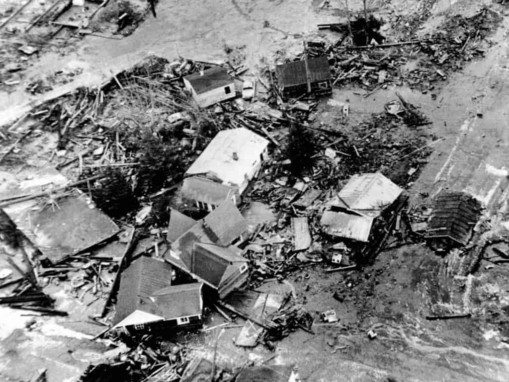
The 1964 Alaska earthquake caused a 30-foot tidal wave that destroyed low-lying areas of the coastal town of Seward.
©Everett Collection/Shutterstock.com
#2 California
The San Andreas Fault is typically the first that comes to mind when most people think about earthquakes in California. Even though it is the longest fault in the state, there are other faults that also call for concern. Right under our cities, in some of the most populous places, lie numerous other faults.
Earthquakes in California are caused by movement along the San Andreas Fault and its multiple associated faults. These form the tectonic boundary between the Pacific and North American plates. The Pacific Plate is slowly advancing to the northwest along this boundary in relation to the North American Plate. All of California west of the San Andreas fault and the majority of the Pacific Ocean are both supported by the Pacific plate.
California records many earthquakes annually, most of which are barely evident. Although few earthquakes are stronger than 3.0 in magnitude, California has experienced deadly, record-breaking earthquakes. According to data released by the USGS, 4,895 earthquakes above magnitude 3.5 struck the Golden State from 1974 to 2003.
The 1906 earthquake, which shook San Francisco on California’s northern coast, was one of the worst to ever occur there. The city was completely destroyed by fire after the 7.8-magnitude earthquake that caused it. About 3,000 lives and $524 million in property damage were lost in what has been regarded as one of the most disastrous earthquakes in US history. The death toll is still the highest in California’s recorded history of natural disasters.
More recently, a 7.1 magnitude struck Ridgecrest in July 2019. It left one person dead and the initial projection of economic damages was between $1 billion and $5 billion.
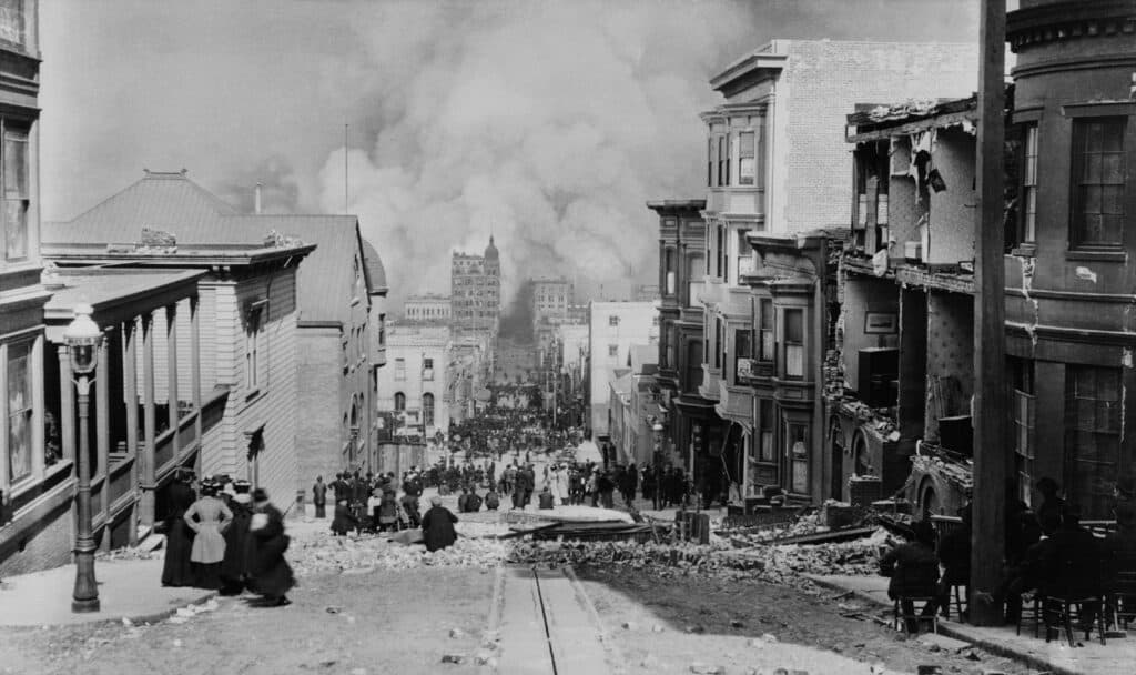
People survey the damage after the 1906 earthquake in San Francisco, California.
©Everett Collection/Shutterstock.com
#3 Hawaii
Typically, Hawaii is known for its islands, beaches, and volcanoes. But, earthquakes? Far from Hawaii, right? Actually, thousands of earthquakes hit the state every year. Hawaii has, in fact, had 1,533 powerful earthquakes between 1974 and 2003.
These earthquakes are triggered by eruptive processes within active volcanoes or profound structural changes caused by the weight of the islands on the Earth’s underlying crust. Most are so small that only sensitive sensors known as seismometers can detect them. Some of them are powerful enough to be felt on one or more of the islands.
Most Hawaiian earthquakes particularly strike the southern districts of the island of Hawaii, the location of the state’s active volcanoes (Kilauea, Mauna Loa, and Kama’ehuakanaloa). The majority of these earthquakes are caused by magma moving within volcanoes, building in shallow reservoirs, or erupting at the volcanoes’ summits or rift zones. Other earthquakes occur in the crust and upper mantle along tectonic faults.
The earthquake record of the USGS shows that there have been an average of 100 earthquakes with a magnitude of 3 or higher (M3), ten with a magnitude of 4 or higher, and one with a magnitude of 5 or higher in the Aloha State each year since 1823. The state also experiences two M7 or larger earthquakes every 100 years on average, and one M6 or larger earthquake every 10 years.
While most Hawaiian earthquakes are barely noticeable, a few big earthquakes cause substantial damage. With a magnitude of 7.9, the earthquake that struck Hawaii in 1868 was the biggest ever. The landslide and tsunami caused by the earthquake claimed 31 and 46 lives respectively. The M5.2 earthquake of 2009 and the M6.7 of 2006 are more recent instances of massive earthquakes in Hawaii.

This photo shows the ruins of the Waiohinu Church in Hawaii after the 1868 earthquake.
©Henry L. Chase / Public domain, via Wikimedia Commons – License
#4 Nevada
The Silver State is one of the states that is most susceptible to earthquakes. A total of 778 earthquakes above 3.5 magnitude have occurred in Nevada, making it the fourth-most seismically active state in the country.
The Western region of Nevada has the highest risk of earthquakes and the largest seismic faults by area size. Wondering what triggers earthquakes in Western Nevada? The extension that is tearing Nevada apart and the tugging produced as the Sierra Nevada is pulled to the north due to it being caught up in the Pacific-North America plate motion.
As a result of the extension, normal faults, such as the Genoa fault, which bounds Carson Valley, the Mt. Rose fault, which bounds Reno, and the basin-bounding faults in the Tahoe basin, such as the West Tahoe—Dollar Point fault, are all created. An earthquake on a typical fault causes the ground to be vertically offset, with one side falling and the other rising
On May 15, 1915, an earthquake in the Pleasant Valley ravaged the state of Nevada. The northern region of the state experienced a considerable change in the course of streams and springs as a result of the 7.1-magnitude earthquake.

Nevada is the fourth-most seismically active state in America.
©iStock.com/Fyletto
#5 Washington
With 424 powerful earthquakes between 1974 and 2003, Washington is one of the top 5 on the list of American states vulnerable to earthquakes.
In what has been described by experts as the “triple threat”, earthquakes occur in the Evergreen State due to the shallow quakes on the Seattle Fault, deep quakes around the Puget Sound area, or the Cascadia subduction zone which is part of the Pacific Rim.
The earthquake that struck Washington on February 28, 2001, ranks among the strongest ones to have ever struck the state. The epicenter of the 6.8-magnitude earthquake was situated in Southern Puget Sound, northeast of Olympia. Areas including Idaho, Oregon, and Canada felt the shock waves. Out of the 400 or so persons who were injured by the earthquake, only one person died as a result of a heart attack while property losses were projected to be $2 billion.
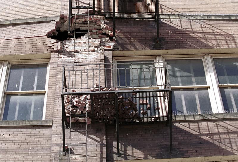
The 2001 earthquake in Washington caused an estimated $2 billion in property damage.
©Kevin Galvin, Public domain, via Wikimedia Commons – License
Summary Of The States With The Highest Earthquake Risk
| Rank | State | Why |
|---|---|---|
| 1 | Alaska | Its location along the Pacific “Ring of Fire” and the way it connects the Pacific & North American plates |
| 2 | California | Movement along the San Andreas Fault & its multiple associated faults that form the tectonic boundary between the Pacific & North American plates |
| 3 | Hawaii | Triggered by eruptive processes within active volcanoes or profound structural changes caused by the weight of the islands on the Earth’s underlying crust |
| 4 | Nevada | The tugging produced as the Sierra Nevada is pulled to the north due to it being caught up in the Pacific-North America plate motion |
| 5 | Washington | Due to shallow quakes on the Seattle Fault, deep quakes around the Puget Sound area, or the Cascadia subduction zone which is part of the Pacific Rim |
The photo featured at the top of this post is © Inked Pixels/Shutterstock.com


Sources
- III, Available here: https://www.iii.org/article/us-earthquake-history
- National Geographic, Available here: https://education.nationalgeographic.org/resource/earthquakes
- World Atlas, Available here: https://www.worldatlas.com/articles/the-most-earthquake-prone-us-states.html
- Apartment Guide, Available here: https://www.apartmentguide.com/blog/most-common-states-for-earthquakes/
- CNN, Available here: https://edition.cnn.com/2018/12/01/us/alaska-why-so-many-earthquakes/index.html
- USGS, Available here: https://www.usgs.gov/faqs/can-you-predict-earthquakes
- NOAA, Available here: https://sos.noaa.gov/catalog/datasets/tsunami-historical-series-aleutian-islands-1946/
- Info Please, Available here: https://www.infoplease.com/askeds/what-state-has-never-had-earthquake
- Earthquake Country, Available here: https://www.earthquakecountry.org/southerncaliforniacoast/
- Shakeout, Available here: https://www.shakeout.org/nevada/western/
How to Add Us to Google News


FAQs (Frequently Asked Questions)
Can you predict earthquakes?
The short answer is no. According to the USGS, three things must be specified in an earthquake prediction: the location, the magnitude, and the day and time. As such, a notable seismic occurrence has never been foretold by the USGS or any other scientific organization.
However, the scientists at USGS can predict the likelihood that a large earthquake will happen in a certain place during a given period of time with the aid of their hazard mapping.
What state has never had an earthquake?
The Earthquake Information Center of the USGS says that every state in the United States has suffered some sort of earthquake. Florida and North Dakota are listed as the states with the fewest earthquakes.
Thank you for reading! Have some feedback for us? Contact the AZ Animals editorial team.