

If the United States is good at one thing when it comes to infrastructure planning, it’s probably our highway system. Originally founded by President Dwight D. Eisenhower in 1956, the U.S. Highway system is the backbone for domestic trade and travel and has almost become a cultural phenomenon for the country. Van life, car culture, and road trips aren’t uniquely American in nature, but they are easily folded into the highway-centric lifestyle of most Americans. In fact, taking road trips isn’t even for the destination; it’s for the travel itself! Today, we are all about celebrating the journey over the destination, and a road trip is the epitome of that. Let’s take a look at some of the most scenic road trips in the U.S., plus some of the best stops along the way.
There are a ton of roads and scenic highways in the U.S., and it isn’t possible to totally include them on every list. Here’s our take on some of the most notable (in no special order), doing our best to spread them across the country in a way that includes the major regions. Let’s get started!
1. Blue Ridge Parkway
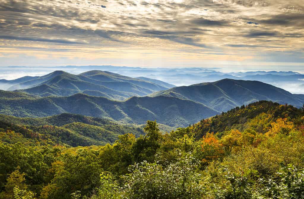
There are countless overlooks and scenic views of the Appalachian Mountains along the Blue Ridge Parkway.
©Dave Allen Photography/Shutterstock.com
The Blue Ridge Parkway is maybe one of the most famous drives in all of the United States, potentially the world. In fact, it’s more than just a road; it’s a journey through the Appalachian Mountains of Virginia and North Carolina and is absolutely gorgeous. From north to south, it’s America’s longest linear park and one of the most popular destinations for campers, hikers, and day trippers.
Tip: Take the trip during peak season in the fall for some of the best views of your life.
The Parkway connects Shenandoah National Park in Virginia to the Great Smoky Mountains National Park in North Carolina. It is at a high elevation most of the way and passes along rocky ridges, stunning valleys, and through some of the best forest land and farms along the east coast. On top of the scenery, it’s a fantastic way to learn about the culture of Appalachia since there are countless towns, parks, museums, and attractions it takes you through or near on the journey. The Parkway spans 469 miles and can be driven in about 12 hours, but you’ll want to take your time and explore some of the best stops along the way.
Some of the most notable stops along the way include:
- Natural Bridge (Milepost 61.6)
- Peaks Of Otter (Milepost 86)
- Mabry Mill (the most photographed site on the parkway) (Milepost 176.1)
- Blue Ridge Music Center (Milepost 213)
- Linville Falls (Milepost 316.4)
- Little Switzerland (Milepost 334)
- Mount Mitchell, the highest peak on the east coast (Milepost 355.4)
2. Route 66
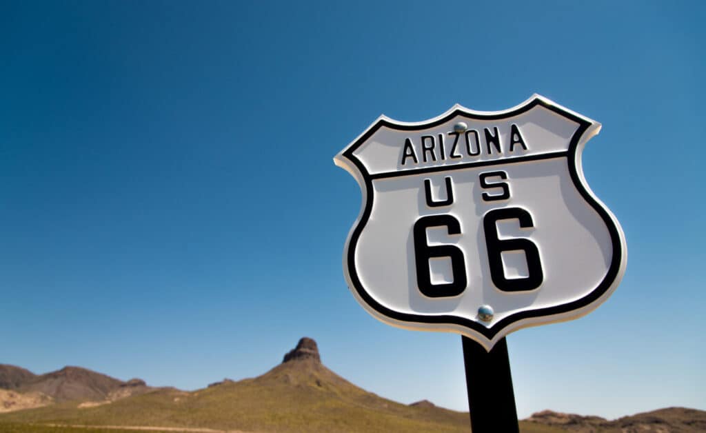
Traveling from Chicago to Santa Monica, Route 66 is one of the most famous road trips in the U.S.
©Mike Flippo/Shutterstock.com
Route 66 is pretty much THE symbol of America’s spirit of adventure and freedom. It was one of the first national highways for motor vehicles in the United States, established in 1926, and it ran from Chicago, Illinois, to Santa Monica, California, covering a total of 2,448 miles. It crossed eight states and three time zones, all the while passing through some of the most diverse landscapes in the country. It also connected some smaller towns and rural communities that otherwise would have been isolated from the rest of the nation (as Mater and Lightning McQueen so wonderfully showed us).
Route 66 became an icon in American popular culture. It had nicknames like the “Mother Road”, and the “Main Street of America”. Many people drove along Route 66 during the Great Depression, the Dust Bowl, and World War II when a huge country-wide migration to the west began. Later, it became a popular destination for tourists, bikers, and road trippers who wanted to experience authentic “Americana” along the way.
Route 66 was gradually replaced by the Interstate Highway System, however, and the last section of Route 66 was decommissioned in 1985. That being said, many parts of the original route still exist and are preserved as historic landmarks or designated as scenic byways. While the stops along the highway are mostly icons now, the drive itself is incredibly unique and showcases tons of landscapes only found in those portions of America. Some of the most notable stops along Route 66 are:
- The Art Institute of Chicago (Illinois), The starting point of Route 66, where you can see a sign that says “Begin Historic Route 66”
- Chain of Rocks Bridge (Missouri)
- Cadillac Ranch (Texas)
- Petrified Forest National Park (Arizona)
- Wigwam Motel (Arizona)
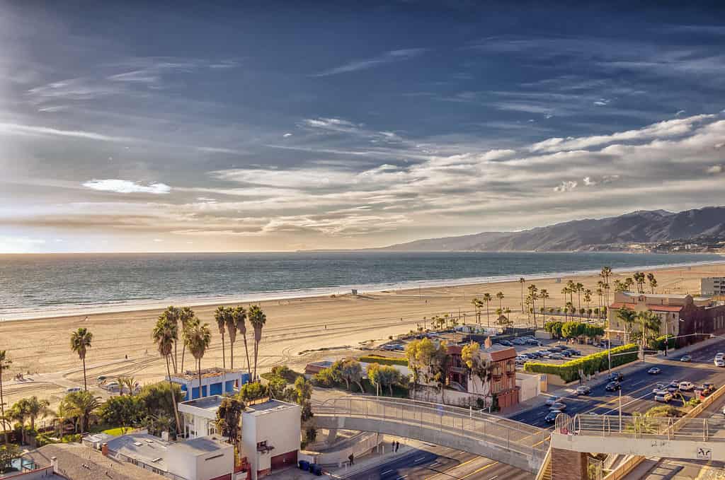
- Santa Monica Pier (California): The end point of Route 66, where you can see a sign that says “End of the Trail”
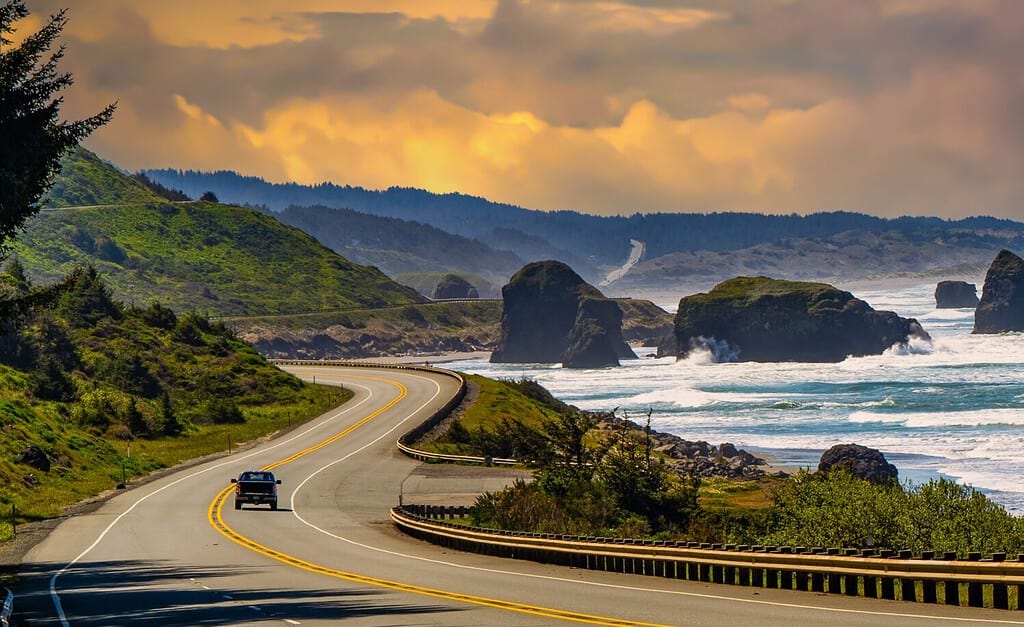
3. Highway 1
The Pacific Coast Highway (Highway 1) covers some spectacular views of the Pacific Ocean along its long route.
©iStock.com/Ed-Ni-Photo
Are we allowed to pick favorites? Well, if we are, Highway 1 is on the list as one of the best scenic coastal roads ever created. It is truly idyllic.
Highway 1 in California, also known as State Route 1 or the Pacific Coast Highway (usually shortened to PCH), is a major north–south state highway that runs along most of the Pacific coastline of the U.S. state of California. At 656 miles, it is the longest state route in California and the second-longest in the US after Montana Highway 2001.
The views on Highway 1 are endless. Vistas overlooking the ocean, redwood trees in the north, cliffs that fall right off into the sea, and so much more. The most photographed portion runs along the middle of the state’s shoreline from Santa Barbara to Monterey. It goes through the “unspoiled” areas of Big Sur, unspoiled meaning undeveloped. Some of the must-see spots along Highway 1 in California are:
- Santa Barbara Mission (Santa Barbara)
- Pismo Beach (San Luis Obispo County)
- Elephant Seal Rookery (Piedras Blancas)
- Hearst Castle (San Simeon)
- Bixby Creek Bridge (Big Sur)
- Point Lobos State Natural Reserve (Carmel)
- Monterey Bay Aquarium (Monterey)
The stops are great, but the views are really what you head to the PCH for. Bonus points if you can score a convertible!
4. Highway 101
Highway 101 drifts between coastal views and inland landscapes, all of which are stunning.
©Bob Pool/Shutterstock.com
Highway 101 and Highway 1 (the PCH) can sometimes get confused, but they are quite different (although both pass through California). The 101 is a much more inland route that runs somewhat parallel to the PCH and sometimes overlaps with it. Where the PCH is dedicated to hugging the shoreline as much as possible and offering Pacific views, Highway 101 takes you through wine country, farmland, national parks, and so much more. Also, it doesn’t skimp on the Pacific views; they are just further north towards Oregon and Washington. This scenic road is like the cousin of the PCH.
It also passes through many historic and cultural landmarks, such as the Golden Gate Bridge, the Redwood National Park, and the Oregon Dunes National Recreation Area. Highway 101 is one of the longest and oldest highways in the country, dating back to 1926. It follows parts of the original El Camino Real, a Spanish colonial route that linked 21 missions in California. It also overlaps with the Oregon Coast Highway. Some of the must-see spots along Highway 101 are:
- Golden Gate Bridge (San Francisco County)
- Redwood National Park (Humboldt County)
- Oregon Dunes National Recreation Area (Coos County)
- Cannon Beach (Clatsop County)
- Astoria–Megler Bridge (Clatsop County)
- Olympic National Park (Clallam County)
- Seattle Center (King County)
5. Florida Keys
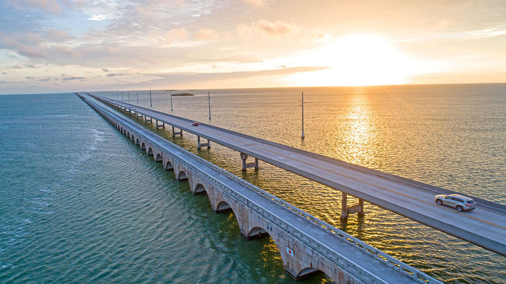
The Seven Mile Bridge is one of the greatest marvels of the Overseas Highway.
©iStock.com/SEASTOCK
Heading back to the East Coast, we have the Florida Keys, also known as the Overseas Highway. The Overseas Highway is basically a tropical scenic road adventure that takes you through the Florida Keys, a chain of islands that extends from the southern tip of Florida to Key West, the southernmost point in the continental United States. The Overseas Highway is a 113-mile highway that carries U.S. Route 1 through the Keys, crossing 42 bridges over the Atlantic Ocean, Florida Bay, and the Gulf of Mexico.
The Overseas Highway is truly a modern wonder. It was built on the former location of the Overseas Railroad, a historic railway that connected Miami to Key West from 1912 to 1935. The railroad was destroyed by a hurricane in 1935 and was replaced by the highway in 1938. The Overseas Highway offers stunning views of the turquoise water, mangrove forests, and islands along the way. It also takes you through little towns and seaside getaways that are all worth a guide on their own. The Overseas Highway is a popular destination for road trippers, boaters, divers, fishermen, and more. Some of the must-see spots along the Overseas Highway are:
- John Pennekamp Coral Reef State Park (Key Largo)
- Theater of the Sea (Islamorada)
- Seven Mile Bridge (Marathon)
- Bahia Honda State Park (Big Pine Key)
- Key West: The southernmost city in the continental United States and the end of the Overseas Highway
6. Going-to-the-Sun Road
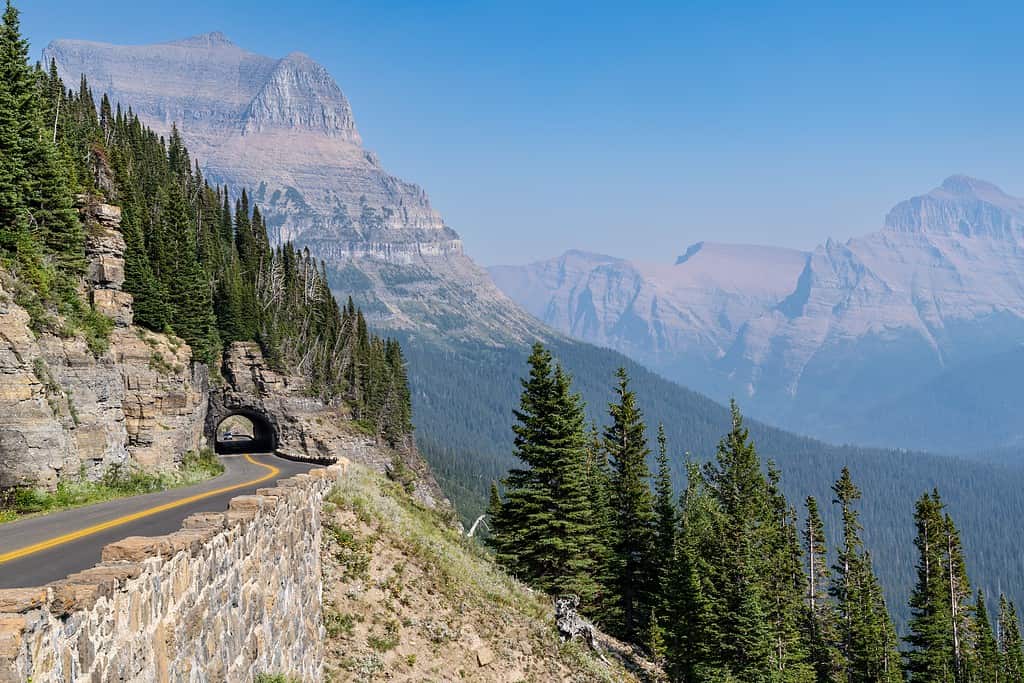
Tunnels and sweeping views await travelers on the gorgeous Going-to-the-Sun Road in Glacier National Park.
©melissamn/Shutterstock.com
Going-to-the-Sun Road is in Glacier National Park in Montana. It is the only road that totally traverses the park, crossing the Continental Divide through Logan Pass at an incredible height of 6,646 feet (which is the highest point on the road). There are three designations that Going-to-the-Sun Road has: it’s National Historic Place, a National Historic Landmark, and a Historic Civil Engineering Landmark, making it one of the most remarkable roads in the country. It was built between 1921 and 1932 but had an official birthday party (designation) in 1933.
It follows parts of the original route of the Blackfeet people, who called it Napi’s Road, after their god who created everything. Going to the Sun Road is about 50 miles long and spans the width of the park between the east and west entrance stations. It offers some immaculate views of the mountains, glaciers, lakes, waterfalls, and wildlife along the way. If you want America’s landscape at its most raw, this is the road for you. Some of the must-see spots along Going to the Sun Road are:
- Lake McDonald (West Glacier)
- Avalanche Creek (West Glacier):
- Logan Pass (Continental Divide)
- Weeping Wall (Continental Divide)
- Bird Woman Falls (Continental Divide)
- St. Mary Lake (St. Mary)
- Wild Goose Island (St. Mary)
- Jackson Glacier Overlook (St. Mary)
- Sun Point (St. Mary)
7. Road to Hana
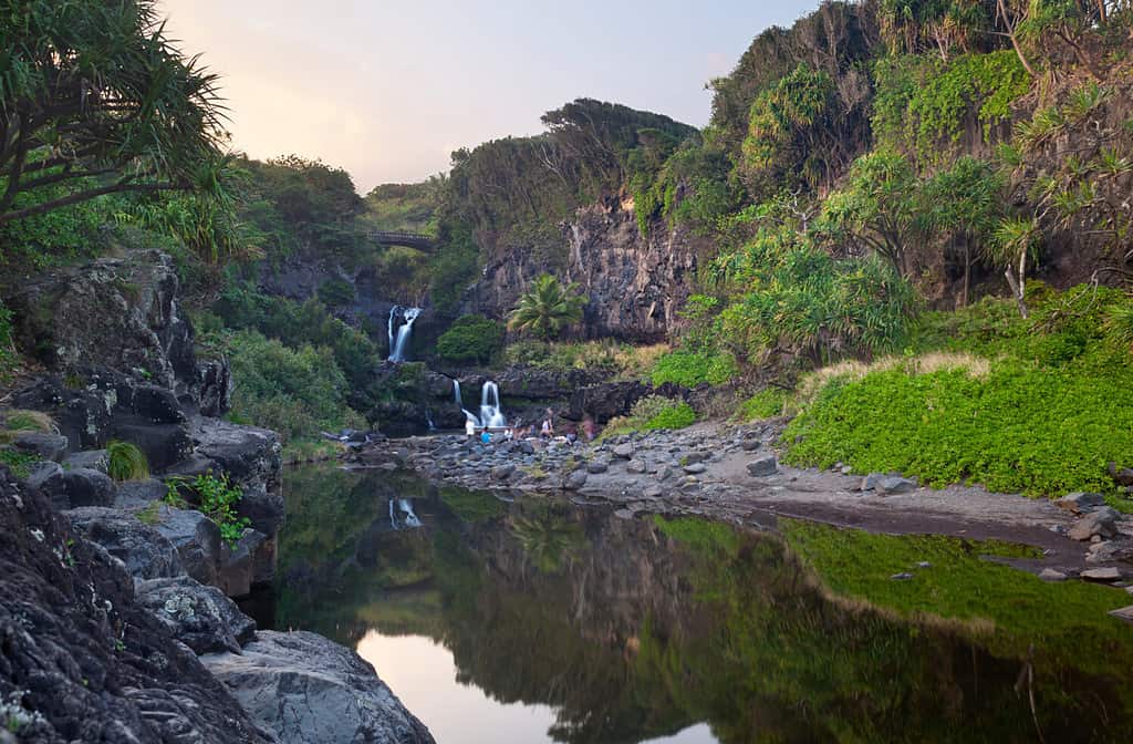
Seven Sacred Pool is a great place to stop and swim for a bit on the Road to Hana.
©IndustryAndTravel/Shutterstock.com
The Road to Hana feels like a magical journey. By the time you make it through and to the other side of the island, it feels like you went through a portal to another land. It is a 64-mile stretch of highway that starts in Paia and ends at Kipahulu, Maui. It passes countless waterfalls, beaches, bridges, and (tasty) fruit stands along the way.
Tip: Make sure your rental car allows you to take your vehicle across the island’s backside. Many require special insurance, and things can get a little rocky if you make the full loop.
The Road to Hana is one of the most famous and scenic drives in the world, but it’s also one of the most challenging to drive. Seriously. It has over 600 curves and 50 one-lane bridges, and the locals fly through the road while tourists crawl along like turtles. It takes about 2.5 hours to drive without stopping, but not stopping here should be a crime. Some of the must-see spots along the Road to Hana are:
- Twin Falls (Mile Marker 2)
- Garden of Eden Arboretum (Mile Marker 10.5)
- Ke’anae Peninsula (Mile Marker 16.8)
- Wai’anapanapa State Park (Mile Marker 32)
- Hana Town (Mile Marker 34)
- Wailua Falls (Mile Marker 45)
- Ohe’o Gulch (Mile Marker 42), otherwise known as the Seven Sacred Pools
8. Great River Road
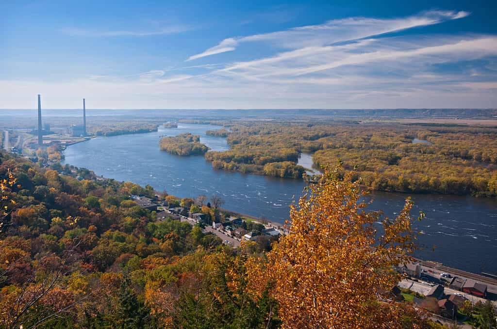
The Great River Road follows the Mississippi River to its mouth in Louisiana.
©Joe Ferrer/Shutterstock.com
Is there anything more American than the Mississippi River? How about a road trip along the Mississippi River! The Great River Road isn’t a single long road, but a collection of state and local roads that follow the course of the Mississippi River along 10 states. Starting in the north, they are Minnesota, Wisconsin, Iowa, Illinois, Missouri, Kentucky, Tennessee, Arkansas, Mississippi, and finally, Louisiana.
The Great River Road is a National Scenic Byway that spans a remarkable 3,000 miles and travels directly through the heart of America. Obviously, it offers views of the river and its surroundings, but its real draw is how it puts you right up next to the culture and history of the Great River itself. Some of the must-see spots along the Great River Road are:
- Itasca State Park (Minnesota), the headwaters of the Mississippi.
- Effigy Mounds National Monument (Iowa)
- Cahokia Mounds State Historic Site (Illinois)
- Gateway Arch National Park (Missouri), but it’s more commonly known as the St. Louis Arch
- Reelfoot Lake State Park (Tennessee)
- Vicksburg National Military Park (Mississippi)
- Natchez Trace Parkway (Mississippi / Alabama / Tennessee)
- Oak Alley Plantation (Louisiana)
- New Orleans (Louisiana)
9. Route 12 Utah
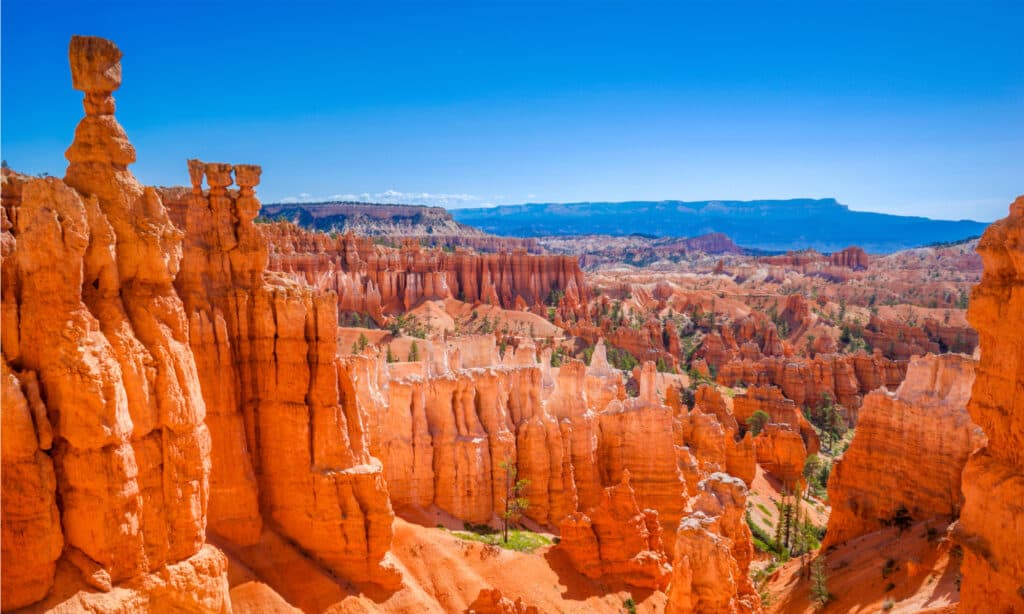
Bryce Canyon is one of the parks found along Route 12 in Utah.
©silky/Shutterstock.com
Route 12 in Utah is a 124-mile highway that runs from Bryce Canyon National Park to Capitol Reef National Park, passing through Grand Staircase-Escalante National Monument and Glen Canyon National Recreation Area along the way. Essentially, this trip is an outdoorsy person’s absolute paradise, plus you get to drive on some incredibly scenic roads.
During the drive, you get incredible views of red rock formations, canyons, mountains, forests, deserts, and rivers. It takes about three hours to drive without stopping, but you’ll want to stop often. Many people even spend a week or two and take the time to hike and camp all around the parks nearby. Some of the must-see spots along Route 12 Utah are:
- Bryce Canyon National Park (Garfield County)
- Red Canyon (Garfield County)
- Kodachrome Basin State Park (Kane County)
- Grand Staircase-Escalante National Monument (Garfield / Kane Counties)
- Calf Creek Falls (Garfield County)
- Boulder Mountain (Wayne / Garfield Counties)
- Capitol Reef National Park (Wayne County)
10. Trail Ridge Road
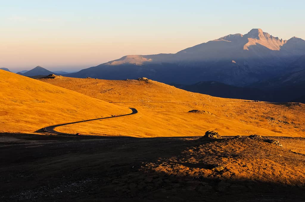
The Trail Ride Road in Colorado is the highest paved road in the U.S.!
©Sean Xu/Shutterstock.com
Back to the Rocky Mountains… of Colorado this time! Trail Ridge Road is the highest continuous paved road in the United States, soaring to an elevation of 12,183 feet at its highest point. Besides being high, it’s also a National Scenic Byway and an All-American Road that spans 48 miles and crosses the Continental Divide at Milner Pass.
During the drive, you can see sweeping views of the mountains, meadows, and forests along the way. It takes about two hours to drive without stopping, but you can’t pass up the opportunity for a beautiful overlook! Some of the must-see spots along Trail Ridge Road are:
- Deer Ridge Junction (Estes Park)
- Many Parks Curve (Estes Park)
- Forest Canyon Overlook (Grand Lake)
- Rock Cut (Grand Lake)
- Alpine Visitor Center (Grand Lake)
- Medicine Bow Curve (Grand Lake)
11. Park Loop Road
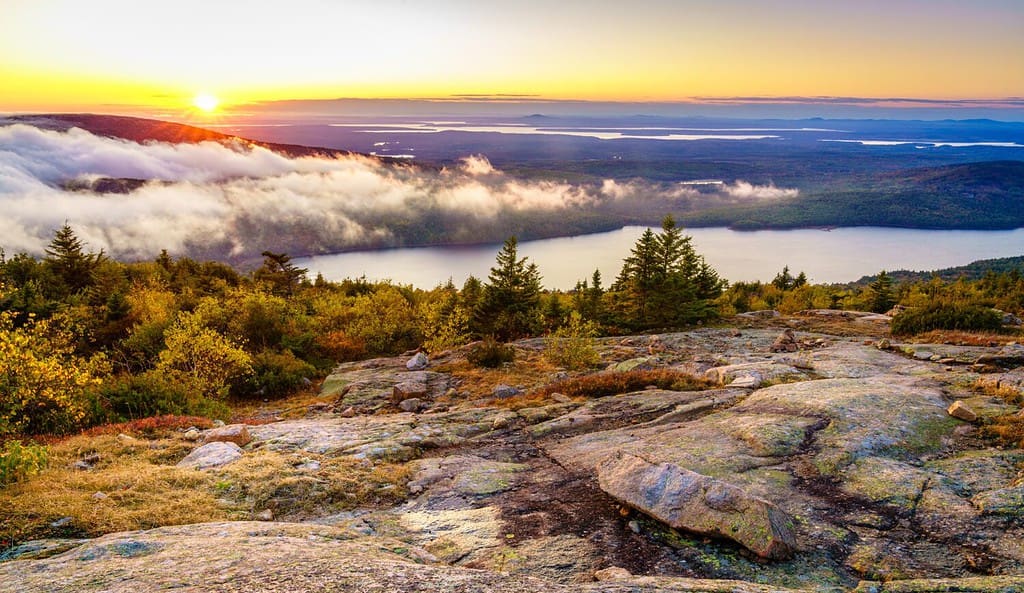
The clash of mountains and rocky shore is part of what makes Acadia National Park so incredible.
©Alexey Stiop/Shutterstock.com
Acadia National Park in Maine is easily one of the coolest places in New England, and the Park Loop Road is maybe the best way to witness it in all its glory, aside from hiking it. It is a 27-mile loop (one of the shorter options on our list) that circles around Mount Desert Island, the largest island in the park. Park Loop Road is a National Scenic Byway and is known for its views of both striking mountains and rocky shores, but also where the two meet in dramatic fashion. There are also plenty of parking areas, picnic spots, hiking trails, and visitor centers along the way. It takes about three hours to drive without stopping. Some of the must-see spots along Park Loop Road are:
- Cadillac Mountain (Bar Harbor)
- Thunder Hole (Bar Harbor)
- Jordan Pond (Mount Desert)
- Sand Beach (Bar Harbor)
- Otter Cliff (Bar Harbor)
12. Road to Taos
New Mexico has a fantastic journey that combines beautiful landscapes with spiritual solemnity.
©Andriy Blokhin/Shutterstock.com
Ready for some desert driving? There really isn’t anything quite like it. Huge landscapes and vast vistas in a car make you feel like you’re in a movie scene, and the Road to Taos is the perfect stage. The trip takes you through a scenic journey across the high desert of northern New Mexico in the Sangre de Cristo Mountains. It is a 56-mile stretch of highway that runs from Santa Fe to Taos, passing by ancient pueblos, historic churches, art galleries, and natural features along the way.
Like a few of our other roads on the list, the Road to Taos is a National Scenic Byway and an All-American Road due to its impressive mesas and unique beautiful landscape. While all of the roads on the list are beautiful, the Road to Taos has a unique cultural element to it. The road passes through many cultural and spiritual landmarks, and there is an air of reverence to many of them. It is steeped in a rich history of influences from Native American, Spanish, Mexican, and Anglo cultures. It was also the route of many famous artists and writers, such as Georgia O’Keeffe, D.H. Lawrence, Ansel Adams, and Mabel Dodge Luhan. Some of the must-see spots along the Road to Taos are:
- Chimayo (Santa Fe County)
- Truchas (Rio Arriba County)
- Las Trampas (Taos County)
- Rio Grande Gorge Bridge (Taos County)
- Taos Pueblo (Taos County)
- Taos Plaza (Taos County)


How to Add Us to Google News


Thank you for reading! Have some feedback for us? Contact the AZ Animals editorial team.