
Nestled in Southeast Asia, Vietnam boasts a diverse climate and geography. The ideal time to visit Vietnam varies depending on your preferences and the regions you plan to explore. However, if you want to avoid massive downpours, one period will reward visitors with warm temperatures, less rainfall, and a lot of sunshine.
Let’s explore why the best time to visit Vietnam is during the months of November to April.
Vietnam’s Climate

The Golden Bridge in Da Nang is one of the most famous attractions in Vietnam.
©Hien Phung Thu/Shutterstock.com
Vietnam’s climate is as diverse as its landscapes, with a wide range of weather patterns experienced throughout the country due to its considerable length and varying topography. Vietnam can be divided into three regions: the North, Central, and South. Each area features distinct climate characteristics.
Northern Vietnam
The climate in Northern Vietnam, including cities like Hanoi and Halong Bay, has four distinct seasons. Winters, from November to February, are chilly and relatively dry, with occasional cold spells. From May to September, summers bring warmth, humidity, and frequent rainfall, especially during the monsoon season. Spring and autumn are brief but pleasant transitional periods with mild weather, making them ideal for travel.
Average temperatures
- Spring has pleasantly warm temperatures from the high 60s to the high 70s °F (20-25°C).
- The summer months have higher temperatures, often reaching mid-80s Fahrenheit (30°) or more.
- Fall is delightful, with mild temperatures between 20-30°C (68-86°F) and less rainfall.
- Winters are relatively cool, with average temperatures ranging from low 50s to high 60s °F (10-20 °C).
Central Vietnam
Central Vietnam, which includes cities like Hue and Da Nang, experiences a tropical monsoon climate. This region is known for its hot and dry season from January to August and a rainy season from September to December. Summers can be scorching, with temperatures often exceeding 30°C (86°F). The central coast is prone to typhoons during the wet season, bringing heavy rains and flooding.
Average Temperatures
- The dry season has hot temperatures ranging from mid-70s to mid-90s °F (24-35°C).
- The wet season, with its heavy rain, brings in cooler temperatures from the high 60s to mid-80s (20-30°C)
Southern Vietnam
Southern Vietnam, encompassing Ho Chi Minh City (formerly Saigon) and the Mekong Delta, features a more consistently tropical climate. It only has two distinct seasons: the wet season, which lasts from May to November, and the dry season, from December to April. The wet season brings heavy rains and occasional flooding, while the dry season offers relief from rain and slightly cooler temperatures.
Average temperatures
- The dry season offers warm and dry weather with temperatures around 77 to 95 °F (25-35°C).
- The wet season experiences high humidity and heavy rainfall, with temperatures ranging from 77 to 90 °F (25-32°C).
Rainfall Patterns
During monsoon season, downpours are very common.
©Morgan Mokrzycka/Shutterstock.com
Vietnam’s diverse geography and topography contribute to distinct rain patterns. Each region experiences its own unique monsoon cycle, resulting in varying amounts of rainfall throughout the year.
Northern Vietnam
During the summer, Northern Vietnam experiences its wet season. Monsoon winds from the South China Sea bring heavy rainfall, with the peak of the rainy season from July to August. This period is characterized by frequent downpours, often leading to flooding in low-lying areas. Still, these heavy rains are essential for cultivating rice, a staple crop in this region. The average annual rainfall in this region is around 1,500-2,000 millimeters (59 to 79 inches). This equals approximately 150 to 400 millimeters a month (6 to 15.7 inches)
The winter monsoon blows from the northeast. This season sees significantly less rainfall, with some areas experiencing drought conditions and as low as 10-20 millimeters (0.4 to 0.8 inches) of rain a month. January and February are the months with the least precipitation.
Central Vietnam
Cities like Da Nang, Hue, and Hoi An experience a more complex rain pattern due to the influence of the northeast and southwest monsoons. The wet season typically lasts from September to December, with the highest rainfall in October and November. During this period, the southwest monsoon brings warm, moist air from the sea. The monthly rainfall can reach 500-800 millimeters (19.7-31.5 inches) or more, leading to occasional flooding.
In contrast, from January to August, the dry season sees much less rainfall, with some months receiving as little as 20mm of precipitation. The dry season is an excellent time for beach vacations and exploring the historical and cultural treasures of the region.
Southern Vietnam
Southern Vietnam experiences a more uniform pattern of rainfall. The wet season extends from May to October, with peak rainfall occurring in June, July, and August. During this period, the monsoon brings heavy rain. It can range from 200-400 millimeters (7.9-15.7 inches), facilitating the annual flooding of the Mekong Delta, a crucial part of the region’s agricultural cycle.
The dry season is marked by significantly reduced rainfall from November to April, making it an ideal time for outdoor activities and exploring the region’s vibrant culture.
Sunshine and Cloud Cover

Vietnam boasts stunning landscapes like Halong Bay.
©Nguyen Quang Ngoc Tonkin/Shutterstock.com
Once again, sunshine and cloud cover in Vietnam vary depending on the region and the season.
Northern Vietnam is the least sunny region of the country. During the summer monsoon, clouds abundantly cover the skies, leaving very few days with sunshine. However, in the fall, winter, and spring, rainfall leaves its place to clear blue and sunny skies. Sunshine ranges from 1,300 hours to 1,800 hours, depending on the city.
Due to their coastal locations, Da Nang, Hue, and Hoi An enjoy a relatively consistent amount of yearly sunshine. The region experiences from 2,000 to 2,5000 hours of sunshine annually. During the monsoon, some days can be pretty cloudy.
Southern Vietnam is the sunniest region of the country. Ho Chi Minh City and the Mekong Delta are famous for their tropical climate with ample sunshine. Annually, the area receives around 2,400 to 2,800 hours of sunshine. The wet season brings rainy and cloudy days but still leaves abundant sunshine.
Wind and Storms
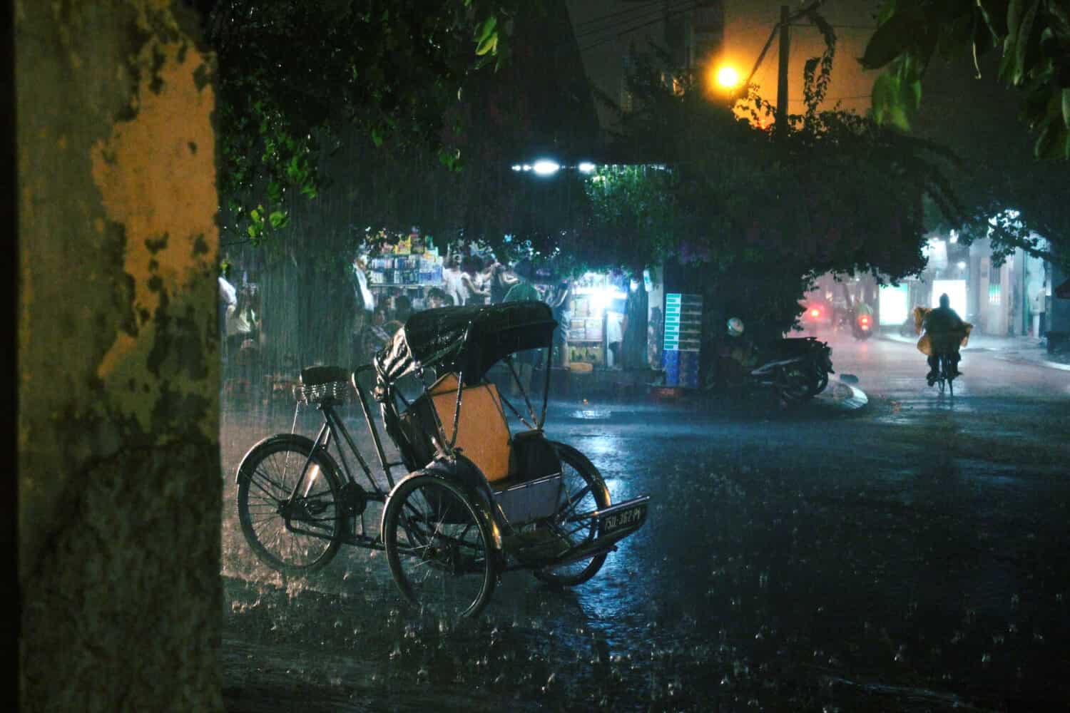
Heavy rainfall can be extremely sudden, sometimes trapping inhabitants.
©Huy Thoai/Shutterstock.com
During the wet season, Vietnam is influenced by the southwest monsoon. This seasonal wind, which typically blows from May to September, brings warm, moist air from the South China Sea. As this moisture-laden air rises over Vietnam’s mountainous terrain, it cools and condenses, leading to heavy rainfall. The southwest monsoon is responsible for the abundant rain experienced in the central and southern regions, facilitating the growth of crops and contributing to the Mekong Delta’s fertile lands.
In contrast, the dry season in central and northern Vietnam, which roughly lasts from November to April, is characterized by the northeast monsoon. This monsoon brings cooler, drier air from the north, resulting in lower humidity and reduced precipitation. The northeast monsoon contributes to more comfortable temperatures and is often associated with clear skies and sunny weather.
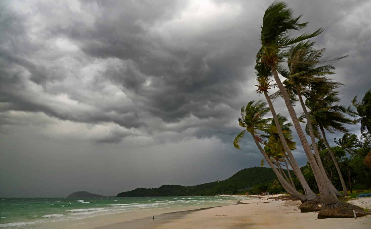
Typhoons and Tropical Storms
Vietnam is also prone to tropical cyclones in the western Pacific Ocean, known as typhoons. These storms can profoundly impact the country, particularly during the typhoon season, which typically runs from May to November.
- Typhoon Formation: Typhoons form over warm ocean waters, and when they approach Vietnam, they can bring torrential rains, strong winds, and storm surges.
- Impact on Rainfall: Typhoons often contribute to heavy rainfall, especially in the central and northern regions. This can lead to flooding and landslides, affecting communities, agriculture, and infrastructure.
- Preparation and Response: The Vietnamese government has developed robust systems for monitoring and tracking typhoons, as well as for issuing warnings and evacuating vulnerable areas. These measures help minimize the impact of these powerful storms.
- Coastal Vulnerability: Vietnam’s extensive coastline is particularly vulnerable to typhoon-induced storm surges. Coastal communities, especially in the central region, risk flooding and damage from high tides and waves during typhoon landfalls.
Wind and storms, including monsoons and typhoons, are integral to Vietnam’s climate and weather patterns. While monsoons are essential for the country’s agricultural prosperity, typhoons pose both opportunities and challenges.
Natural Disasters in Vietnam
Typhoons and hurricanes are the same phenomena; the name changes in function of the region.
©vivanvu/Shutterstock.com
Vietnam is prone to various natural disasters due to its geographical location and diverse topography, including coastal areas, mountains, and deltas. These natural disasters pose significant challenges and risks to the country and have pushed Vietnam to develop robust disaster preparedness and response strategies.
Vietnam’s government and various organizations have implemented disaster risk reduction and response measures, including early warning systems, evacuation plans, and community-based resilience programs, to mitigate the impact of these natural disasters.
Typhoons and Flooding
Vietnam’s long coastline makes it susceptible to tropical storms and typhoons, especially during the wet season. Typhoons can bring heavy rainfall and strong winds, leading to widespread flooding, landslides, and infrastructure damage.
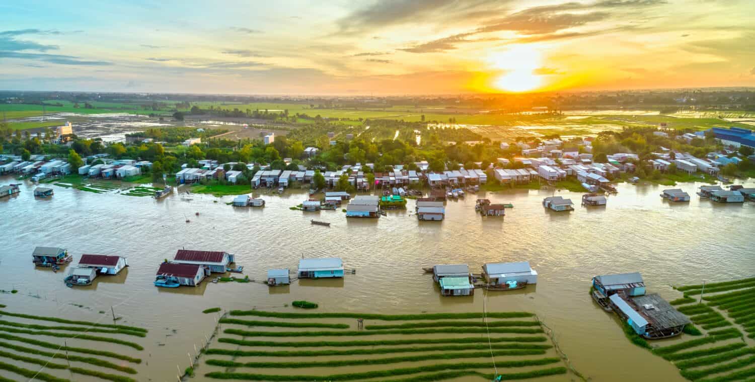
The Mekong Delta, one of Vietnam’s most important agricultural regions, is particularly vulnerable to flooding during the typhoon season. Annual flooding is crucial to the region’s agricultural cycle, but excessive or prolonged flooding can devastate crops and communities.
Saltwater Intrusion
In the Mekong Delta, saltwater intrusion can occur during the dry season, affecting agricultural productivity and freshwater supplies. This phenomenon is exacerbated by sea-level rise and reduced sediment flow in the Mekong River.
Flooding and Landslides
Apart from typhoon-induced flooding, Vietnam also faces seasonal floods during the wet season, resulting from heavy rainfall, river overflows, and inadequate drainage systems. These floods can disrupt daily life, damage homes, and displace communities.
Mountainous areas in northern Vietnam are prone to landslides, especially during heavy rainfall. These landslides can have tragic consequences, causing loss of life and damage to infrastructure.
Drought
In contrast to the wet season, some parts of Vietnam, particularly the central and southern regions, are vulnerable to droughts during the dry season. Prolonged droughts can affect agriculture’s water supply and even lead to water shortages in urban areas.
Tropical Cyclones and Storm Surges
Coastal regions, such as the central provinces, are susceptible to storm surges generated by tropical cyclones. These surges can cause seawater to inundate coastal areas, damaging homes, infrastructure, and agricultural lands.
Earthquakes
Vietnam experiences a lot of low to moderate-intensity earthquakes. In July 2023, 93 earthquakes happened in one month. These ranged from 2.5 to 4.2 on the Richter scale, but they can still cause damage, especially to older buildings and infrastructure.
Forest Fires
Forest fires can occur in Vietnam’s mountainous, forested, and agricultural regions during dry and hot periods. There has been a drastic increase in forest fires over the past 100 years. While some are due to natural causes, some farmers start fires for agriculture. These usually get out of hand and turn into large wildfires. They threaten ecosystems’ biodiversity and affect air quality and human health.
The photo featured at the top of this post is © Blue Planet Studio/Shutterstock.com


How to Add Us to Google News


Thank you for reading! Have some feedback for us? Contact the AZ Animals editorial team.