
As an island chain located on top of a series of volcanoes, the state of Hawaii has some pretty unique geography. Hawaii’s volcanoes formed 40-70 million years ago as one of the earth’s tectonic plates moved across a hotspot, that is, a spot where molten magma below the earth’s crust bursts to the surface. Over time, the cooled lava (that’s what magma is called when it reaches the surface) formed the landmasses of the island. Multiple eruptions eventually piled high enough to rise above sea level. The state’s islands (eight major islands and 124 islets) contain six active volcanoes today. That includes Mauna Loa, the largest active volcano on Earth.
Hawaii Is Home to the World’s Tallest Mountain
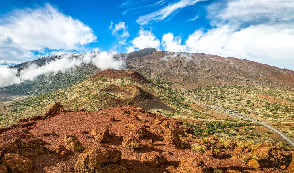
King of the mountains, Hawaii’s Manua Kea is even bigger than it looks.
©Mason Lake Photo/Shutterstock.com
While the Aloha State is known for its mild tropical climate, generally within 75-85 degrees. But some of Hawaii’s volcanic summits are high enough that snow forms on them. This includes Mauna Kea, which at 13,803 feet above sea level stands as the state’s highest peak. Located on the island of Hawaii (aka the Big Island), MK also has the distinction of being the world’s tallest mountain. Sort of.
OK, you’re probably thinking, “Wait a minute…everyone knows that Mount Everest is the world’s tallest mountain!” But technically speaking, Everest is the world’s highest mountain, at 29,029 feet above sea level. If you measure a mountain from its base to its height, Mauna Kea is taller, at 33,500. However, part of Manau Kea is under the ocean, so it doesn’t rise as high above sea level as Everest. (Side note: Despite its height, Everest’s summit isn’t the highest spot on Earth either. That designation goes to Mount Chimborazo, in Ecuador. Because the Earth’s surface bulges a bit in that part of the world, Chimborazo’s peak is further from the center of the Earth than anyplace else in the world.)
Hawaii’s Lowest Point Isn’t a Single Point
Okay, with Hawaii’s highest elevation covered, can we discuss the state’s lowest point? Where is the lowest point in Hawaii anyway? The answer hinges on how geographic elevation is measured. Simply put, elevation is defined as distance above sea level (which is how Everest gets its “highest elevation” label). But what, exactly, is sea level? The sea’s not really level after all, it’s in constant motion. So sea level is measured by two main methods. Tide gauges measure changes in coastal water levels over time, and satellite altimeters observe global sea surface height.
So, with sea level being the starting point for measuring elevation, we can say that the lowest point of elevation in Hawaii is exactly zero. And that occurs wherever the islands meet the Pacific Ocean. It’s a distinction that Hawaii shares with other U.S. states that have coastlines. However, some states have locations that dip below sea level, with the country’s lowest point being 282 feet below sea level, located at Badwater Basin in Death Valley National Park, California.
Hawaii’s Lowest Elevation is Growing
Hawaii’s lowest point is moving farther inland.
©iStock.com/okimo
Sea level measurements aren’t just fodder for arguments about which mountain is taller. They show that sea levels are rising as greenhouse gas emissions raise global temperatures. The rate of sea level change has more than doubled through most of the twentieth century. In Hawaii, this has meant accelerated erosion of the state’s beaches and shorelines. Sea levels are rising as fast as one inch every four years. And 66,000 are residents now under threat of coastal flooding due to higher sea levels. As many as 70% of the state’s beaches are threatened by erosion. In response, in 2017 adopted the goals of the Paris Climate Agreement, committing to a reduction in greenhouse gas emissions. Later, In 2021, Hawaii became the first U.S. state to declare a climate emergency.
In concert with climate change, Hawaii’s beach erosion has been accelerated by the building of sea walls to protect coastal properties from the ocean. The barriers of concrete, boulders, or sandbags cause waves to pull sand away from shore and carry it to sea. Over time, this can cause beaches to disappear entirely. This has already happened on the island of Oahu since home development surged in the late 1960s. The state adopted a no-tolerance policy towards sea walls some time ago. But oceanfront property owners frequently construct them anyway, using legal loopholes to avoid penalties.
The photo featured at the top of this post is © Alexandre G. ROSA/Shutterstock.com


How to Add Us to Google News


Thank you for reading! Have some feedback for us? Contact the AZ Animals editorial team.