
I have been traveling for a long time, and I’ve found that one of my favorite things to do is hang out by waterfalls. I know I’m not alone. Humans have been astounded by waterfalls since our time on earth began. There is a great deal of wonder and undeniable power in waterfalls. The rushing rivers that form them, the deep roaring sound of water cascading down into plunge pools below. My love for these incredible natural water features drew me to southern Oregon, where there is a scenic byway named for its proximity to over a dozen different waterfalls. The Rogue Umpqua Scenic Byway – or the “Highway of Waterfalls” – is an enchanting stretch of road that travels past 15 or more beautiful waterfalls.
In May of 2023, I finally drove the highway to visit several of the waterfalls along its course. I left Roseburg, Oregon in the morning with my dog and a dear friend. We headed east along the highway to see what it held.
The Highway of Waterfalls
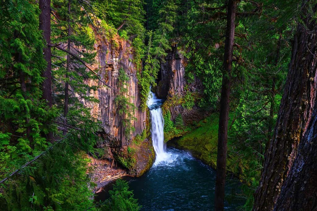
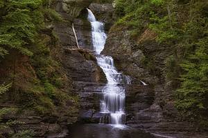
Toketee Falls on the North Umpqua River located in Douglas County, Oregon.
©Nick Fox/Shutterstock.com
The Highway of Waterfalls goes by a few different names. It is the Rogue Umpqua Scenic Byway and NE Diamond Lake Boulevard. It is Highway 138 and North Umpqua Highway No. 138. Regardless of what you call it – the scenery is the same. Our journey starts in Roseburg, Oregon, where the Highway of Waterfalls begins.
The map above shows Roseburg, and you can clearly see the marker for Highway 138. Many sources list the length of this highway as about 172 miles. In the map below, our course takes us 100 miles total. We begin at the start of the highway in Roseburg. Then, we follow the highway east along the North Umpqua River and through the Umpqua National Forest. We pass Diamond Lake and end our trip at the intersection of Highway 138 and Highway 97.
So, why 172 miles? The KOA website offers some sort of explanation. It recommends following Highway 138 to its intersection with Oregon Route 230. Follow Route 230 west along the Rogue River. It becomes Route 62 near Union Creek and goes on to meet Route 234, which takes you right into Gold Hill, Oregon. This is the terminus of the recommended trip. Described as a “loop”, this course traverses 164 miles in a partial loop. We have included one more map to show you what a full loop looks like. The full loop is 249 miles in length.
How Many Waterfalls?
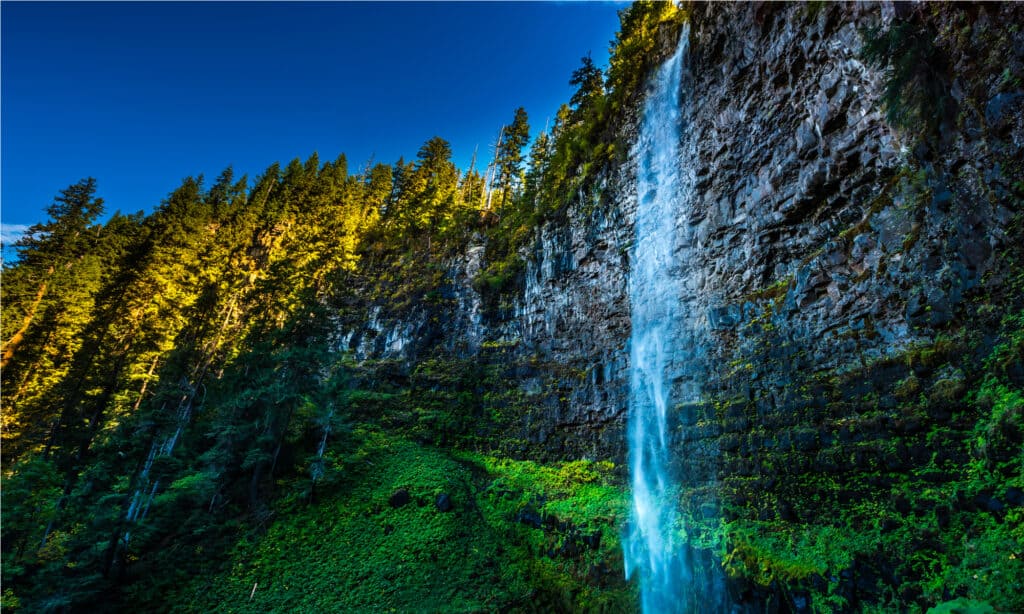
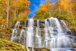
Watson Falls is the tallest waterfall in southern Oregon, and one of the most impressive sights on the Highway of Waterfalls.
©Kris Wiktor/Shutterstock.com
There are at least 15 waterfalls in the 100-mile stretch of the Highway of Waterfalls. You’ll see even more waterfalls if you continue the route toward Gold Hill. Let’s look at 15 waterfalls along or accessed by Highway 138. I’ve highlighted in bold the waterfalls we managed to visit on our drive.
| Waterfall Name | Height |
|---|---|
| Deadline Falls | 12 feet |
| Fern Falls | 60 feet |
| Susan Creek Falls | 50 feet |
| Fall Creek Falls | 120 feet |
| Little Falls | 10 feet |
| Steamboat Falls | 20 feet |
| Redman Creek Falls | Unknown |
| Jack Falls | 200 feet |
| Slide Creek Falls | 137 feet |
| Toketee Falls | 113 feet |
| Watson Falls | 293 feet |
| Whitehorse Falls | 14 feet |
| Clearwater Falls | 29 feet |
| Lemolo Falls | 165 feet |
| Warm Spring Falls | 60 feet |
Best Waterfalls
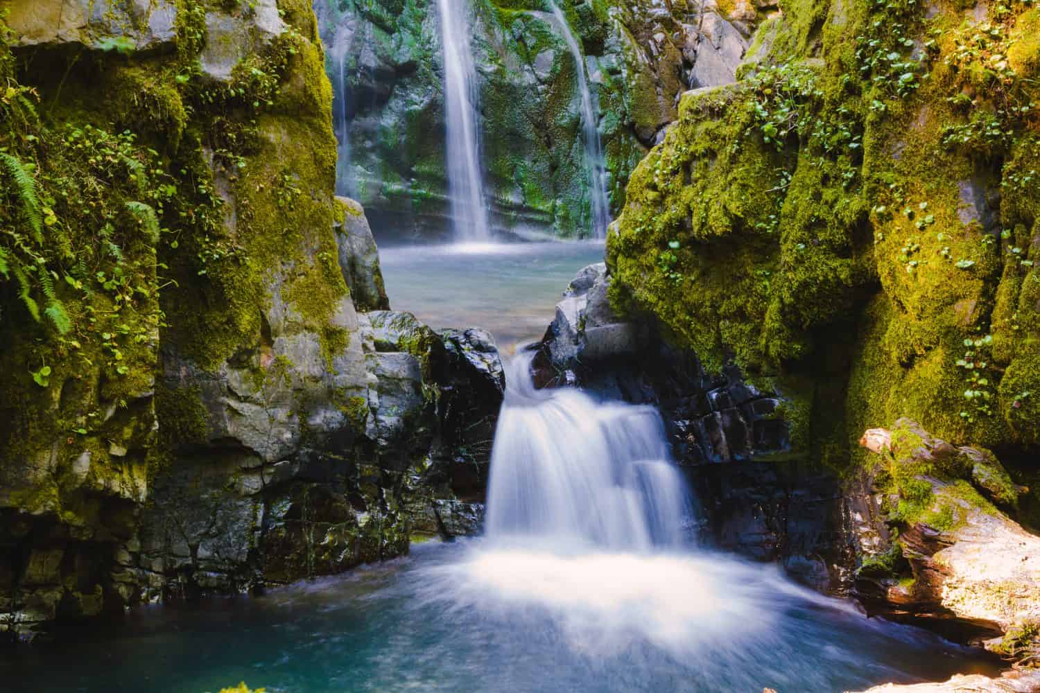
Susan Creek Falls was our very favorite stop on the Highway of Waterfalls.
©Joshua Rainey Photography/Shutterstock.com
I’m going to split this section in two. The first will cover the best waterfalls I visited on my trip. The second will discuss the best waterfalls on the route, whether or not I saw them!
My Favorite Waterfalls
Our personal favorite waterfall was Susan Creek Falls. It was not the largest or most impressive waterfall on the route, but it was perfect for us. The trail was winding and beautiful, even with some burn damage from seasonal wildfires. It was also a fairly easy hike – 1.5 miles out and back with less than 200 feet of elevation gain. The falls area was gorgeous, with picnic tables down by the river and an incredible view of the falls, which dropped in two tiers. We really liked that we were the only people on the trail when we went. For anyone willing to compromise a little bit of grandeur for a higher chance at solitude, I deeply recommend this hike.
Fall Creek Falls was also excellent. It was a more rugged hike with more elevation gain, but it was absolutely gorgeous. The first part of the hike was my favorite. A small parking lot holds a narrow trailhead with a small bridge to cross the creek. Large boulders and small cliffs rise around the trail, and a number of small rapids and tiny waterfalls appear even here. May was the perfect time for this hike for us. The most astounding part of it was not the incredible waterfall at the end, but the butterflies in this creek area. Hundreds – or even thousands – of swallowtail butterflies covered the ground, rocks, and path in the first quarter mile of the hike.
Toketee Falls didn’t work out for us, since it was so crowded and my dog is so nervous around people in those situations. However, we got to see it from the car and it was astounding even from that perspective!
Best Waterfalls to Visit
If you have limited time on your trip to Highway of Waterfalls, you’re going to want to know the best spots to stop off at. I’ve picked out five of the best waterfalls to visit on your drive. My choices are based mostly on the size/height of the falls, but I factored in other perks, like parking, picnic areas, overall fame, and quality of hike.
- Toketee Falls – most popular on route.
- Watson Falls – tallest waterfall in southern Oregon.
- Lemolo Falls – great challenging hike.
- Susan Creek Falls – great picnic area and easy hike.
- Slide Creek Falls – stunning natural beauty.
The Added Perk of Umpqua Hot Springs
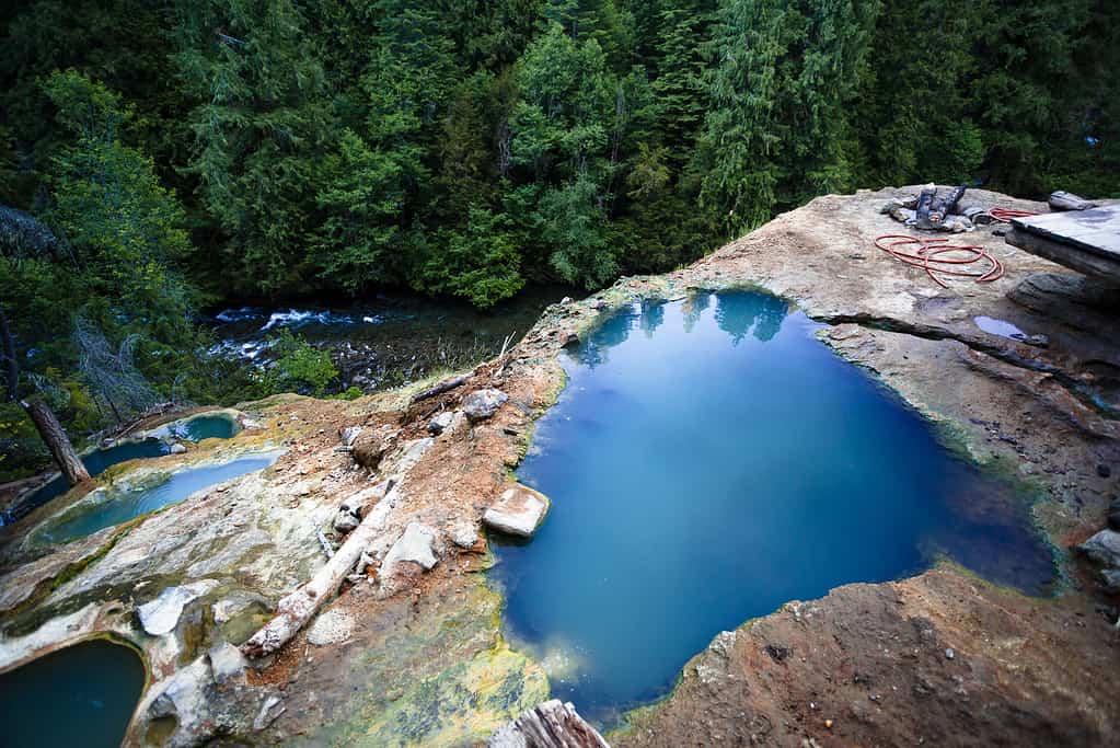
©Joshua Rainey Photography/Shutterstock.com
Waterfalls aren’t the only attraction along the highway. Umpqua Hot Springs is a great stop, as well, boasting beautiful views from mountainside hot pools that vary in temperature. We definitely took the time to stop and check the springs out. It was a tough hike up to the springs in terms of elevation change, but it was less than a quarter mile. This is a very popular spot, and dogs run off-leash in many areas, including the parking lot. Use these springs at your own risk – they are natural springs with no resort or on-duty caretaker. There is a small parking/day use fee of five dollars.
The photo featured at the top of this post is © Stephen Moehle/Shutterstock.com
How to Add Us to Google News


Thank you for reading! Have some feedback for us? Contact the AZ Animals editorial team.