
Rivers are the veins of Earth through which nourishment flows—to both the natural and human worlds. They cradle vibrant ecosystems and sculpt our landscapes. They are the living henges we build so much culture, recreation, and commerce around. And their clarity, or lack thereof, points to their health, or lack thereof. And in many ways, our rivers’ health mirrors that of our own. In the expansive lands of Canada, many flow hale and lucid.
In the Great North, there are countless crystalline rivers, natural wonders that stretch from British Columbia’s rugged peaks to the sweeping tundra of the Northwest Territories. But if we had to choose 10 from this liquid bounty, they would be the following. Each river is a mix of geology, climate, ecology, and human endeavor. To better appreciate their clarity, we first explore the elements that make a river especially clear.
Just to be Clear, or The Key Factors of Clear Rivers
Fast flow
Imagine a river as a giant conveyor belt, swiftly moving fine solids along its course. This fast flow keeps these particles in suspension, reducing their impact on water clarity.
Neutral pH Balance
Just like Goldilocks, rivers prefer their pH “just right.” That is, they want to hit that midway point between zero to less-than-seven and base more-than-seven-to-fourteen. A neutral pH balance is ideal for maintaining clear water, as it prevents the growth of certain algae and bacteria that can cloud the water.
Minimal Pollution and Human Impact
In the search for clear rivers, minimal pollution and low human impact are key factors that often go hand-in-hand. Rivers far from human activities naturally have fewer pollutants and sediments. These remote locations act as shields against erosion, algae growth, and runoff, all of which compromise water clarity.
Conversely, rivers near agriculture, industry, or urban areas suffer from increased pollution and sedimentation, negatively impacting their clarity. Therefore, in evaluating a river’s condition, remoteness is a critical determinant of water quality. In essence, rivers undisturbed by human activity offer a benchmark for what pristine waters can look like.
Geology and Topography
The geology of a stream and the topography of the surrounding land can also affect water quality. For example, a river flowing through a rocky area may have clearer water than one flowing through a muddy floodplain.
Biological Factors
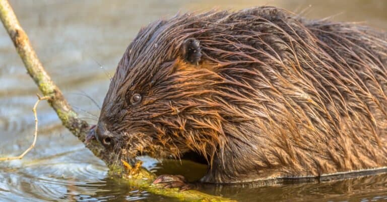
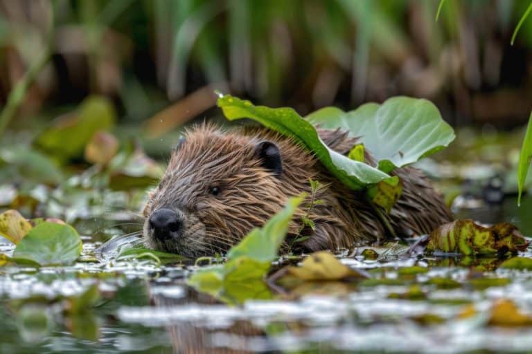
The plants and animals that live in the stream can change conditions within it. For example, beavers can create dams that slow down the flow of the river. These dams allow sediment to settle and make the water clearer. Smart animals.
Biodiversity Hotspots
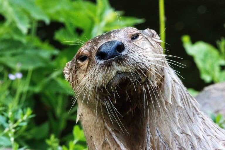
Clear rivers are like bustling city streets for aquatic life. They provide habitats for a diverse range of species, including fish, plants, and wildlife. They are essential for the survival of many species.
Self-Purification
Rivers act as nature’s own water treatment plants (yes, they contain water and often plants). They naturally purify themselves, a process you can measure through ecological functions like nutrient retention.
Drinking Water
Many rivers provide clean drinking water. In fact, 60 percent of our drinking water comes from rivers and other surface waters.
Electricity Generation
Municipalities often use rivers for generating hydroelectric power. This renewable energy source helps reduce our reliance on fossil fuels.
Transportation
We use rivers for transportation, bringing grains, timber, and imports to market. Even today, they are water highways for goods.
Recreational Draw
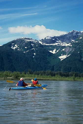
Kayaking, fishing, and photography come alive on crystalline rivers, where fish glide visibly below your boat.
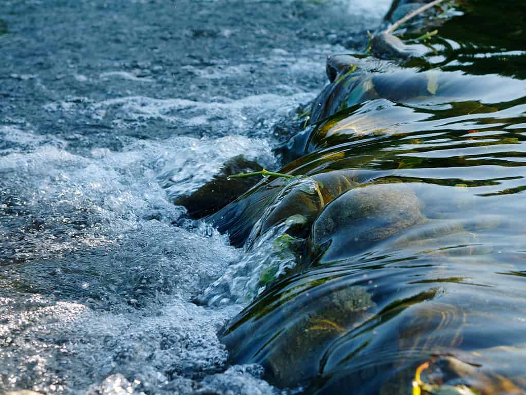
Fast flowing (i.e., not stagnant) water is not only essential for clarity, but serves important electricity-generating dams for people.
©DK Media/iStock / Getty Images Plus via Getty Images
Criteria for Selection
The selection of the 10 clearest rivers in Canada was based on a comprehensive methodology that considered several key factors:
Water Visibility
This is perhaps the most obvious criterion. We often judge the clarity of a river by how far we can see into the water. Scientists typically measure this using a Secchi disk, a circular disk lowered into the water until it can no longer be seen.
Ecosystem Health
A healthy river ecosystem is often a clear one. This includes factors such as biodiversity, the presence of native species, and the absence of invasive species. A diverse and balanced ecosystem can help maintain water clarity by preventing the overgrowth of certain organisms that could cloud the water.
Natural Water Flow
Rivers with a natural flow regime including seasonal variations in flow tend to be healthier and clearer. Dams and other alterations to a river’s flow can disrupt its ecology and reduce clarity.
We used these criteria to evaluate rivers across Canada. While there are many clear rivers in the country, the ones selected stood out for their exceptional clarity and the pristine nature of their ecosystems.
Spotlight on 10 Canadian Rivers that Embody Clarity
The Golden Ears Mountain keep watch over the Alouette River.
©kongxinzhu/iStock via Getty Images
Alouette River, British Columbia
Formed by the confluence of its North and South branches, the Alouette River is a Pitt River tributary in British Columbia. The river cascades over a modest waterfall as it flows out of Golden Ears Provincial Park, offering breathtaking vistas.
Covering 144 km² (or about 35,583 acres), the Alouette watershed originates in the Coastal Mountains of Golden Ears Provincial Park, just 50 km (31 miles) northeast of Vancouver. Its upper reaches feed into Alouette Lake.
The river is clear and bright, and it looks almost as green as the lush forest around it. It’s a popular destination for outdoor pursuits such as canoeing and rafting. However, it isn’t always a “lazy,” slow-moving current, so it’s not ideal for small children.
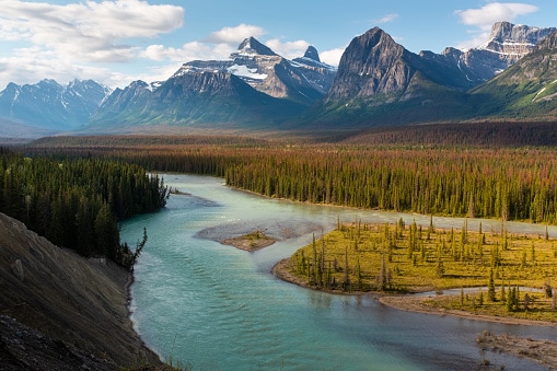
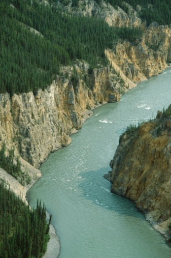
Dramatic cliff faces frame the Athabasca River.
©Samsaphotos/iStock via Getty Images
Athabasca River, Alberta
Alberta’s longest river, the Athabasca, stretches 1,538 km (956 miles) from its source at Jasper National Park’s Columbia Icefield to Lake Athabasca. The initial 168 km (101 miles), located within Jasper, are honored as a Canadian Heritage River.
Navigating icefields and gorges, the river sustains diverse habitats from its shores to adjacent marshes. It traverses four ecological zones. Namely, the Rocky Mountains, Foothill Forests, Temperate Grasslands, and Boreal Forests. Each zone teems with unique plant and animal life. From alpine firs and Engelmann spruce in the Rockies to bighorn sheep and grizzlies, the Athabasca River is a vibrant ecological corridor.
People also know the Athabasca River for its recreational opportunities. It’s a popular destination for outdoor pursuits such as canoeing and rafting. However, there are numerous environmental stressors along the Athabasca River, including forestry, agriculture, pulp and paper mills, and the oil sands deposit.
Nahanni National Park, with the Mackenzie Mountains, is the first natural UNESCO World Heritage site and the source of the Bonnet Plume River.
©JosefHanus/iStock via Getty Images
Bonnet Plume River, Yukon
Originating in the Mackenzie Mountains on the Yukon-Northwest Territories border, the Bonnet Plume River winds over 350 km (217 miles) through diverse terrains—from mountain ranges and rocky slides to canyons and gravel flats—before merging with the Peel River.
Its entire 12,000-km (7,456-mi) watershed is part of the Canadian Heritage Rivers System. A haven for big game like Dall sheep, grizzlies, moose, and caribou, the river has cultural significance too. Known to the Gwich’in as Tsaih Tl’ak Njik, or the “river of black ochre,” it likely refers to area coal seams. The river honors Bonnet Plume, a Gwich’in chief and Hudson’s Bay Company interpreter.
The Tutchone of the Yukon and the Gwich’in of the Norwest Territories and their ancestors have used the Bonnet Plume area continuously for thousands of years for hunting, fishing, trapping, and gathering. The river is very popular with outdoor enthusiasts as a canoe, kayak, or rafting trip. There is a large section of whitewater on the river where it passes through a rockslide canyon.
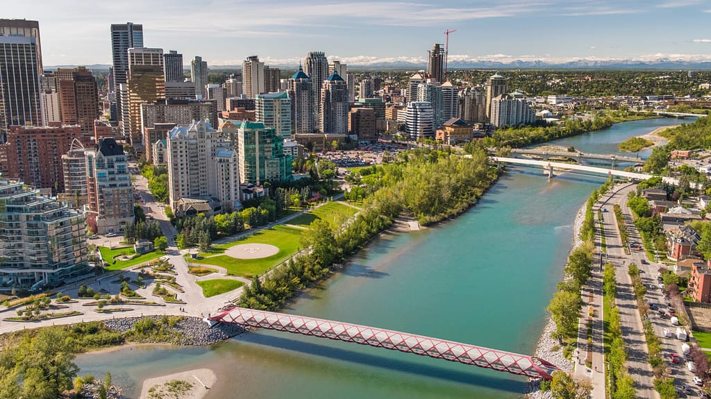
Arguably the liquid core of Calgary, the Bow River has helped sustain First Nations societies for millennia.
©JZAerial Inc/Shutterstock.com
The Bow River, Alberta
As a major waterway, the Bow River has a rich history and plays a significant role in the region’s ecology and human societies. Originating in the Canadian Rockies, it flows through the stunning landscapes of Banff National Park and the city of Calgary before joining the Oldman River to form the South Saskatchewan River.
The river’s name is derived from the Douglas firs that grew along its banks, which were used by the Cree Indians to make bows. The Bow River has been an essential resource for First Nations for thousands of years, providing sustenance and serving as a hunting ground.
European settlers arrived in the late 18th century and established fur trading posts along the river. As the region developed, they negotiated treaties with First Nations to establish reserves along the Bow River.
In the early 20th century, the river underwent significant engineering and hydroelectric development. Engineers constructed dams on the Bow River and its tributaries for various purposes such as hydroelectric power, irrigation, flood control, and Calgary’s water supply. These developments significantly altered the river’s flow and ecosystems.
Today, the Bow River is not only a vital source of water for irrigation and drinking but also a popular recreational area. People consider the Bow River pathway a part of Calgary’s identity. Despite these human impacts, the river continues to support a rich biodiversity and is an integral part of the region’s natural heritage.
From the adjacent Wells Gray Provincial Park, you can appreciate wild lengths of the Clearwater River.
©aprott/iStock via Getty Images
Clearwater River, Alberta & Saskatchewan
The name says it all. The Clearwater River, at 295 km long (183 miles), is a significant river in both Alberta and Saskatchewan. Nearer to its source, the Clearwater River flows over the Precambrian rocks of the Canadian Shield. That section of the river is rough, characterized by rapids, small waterfalls, and a gorge. A salt spring discharges into the Clearwater River in northeastern Alberta.
The 3,100-hectare Clearwater River Corridor contains significant recreation and conservation values. The area has many hiking trails (including a trail to Mahood Lake), spectacular waterfalls, volcanic features, narrow canyons, quality angling and provincially significant river rafting and kayaking opportunities.
The massive Columbia River basin is important to both Canada and the United States.
©iStock.com/JPLDesigns
Columbia River, British Columbia
Originating in British Columbia’s southeast corner, the Columbia River courses 2,000 km (1,243 miles) through Washington and Oregon to the Pacific Ocean. With 801 km (498 miles) in Canada, this mighty river carves deep gorges and oversees one of North America’s largest drainage basins, covering 660,500 km².
Encompassing 258,000 square miles across seven US states and one Canadian province, the Columbia River Basin is vast. Along its 1,200-mile journey to the Pacific, the river crosses four mountain ranges and channels more water into the ocean than any other river in the Americas.
The Columbia River is one of the world’s greatest sources of hydroelectric power and, with its tributaries, represents a third of the potential hydropower of the United States.
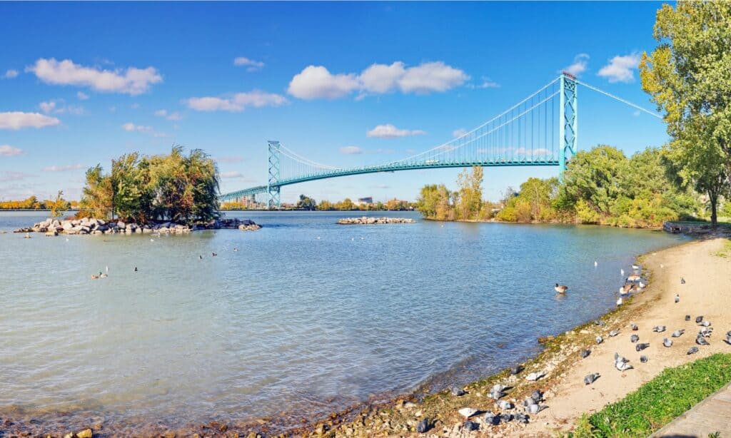
Perhaps the clearest river to cut through a major urban center in North America (the binational Detroit-Windsor area), the Detroit River courses along along the northern border.
©iStock.com/Simplyphotos
Detroit River, Ontario
The Detroit River is a significant waterway that serves as the international border between Canada and the United States. It flows west and south for 24 nautical miles (44 km, or 28 mi) from Lake St. Clair to Lake Erie as a strait in the Great Lakes system. The river divides the metropolitan areas of Detroit, Michigan, and Windsor, Ontario —an area collectively referred to as Detroit–Windsor —and forms part of the border between Canada and the United States.
Named after the French Rivière du Détroit, meaning “River of the Strait,” the Detroit River is a key historical and commercial artery for Detroit and Windsor. As one of the world’s most trafficked waterways, it links Lake Michigan, Huron, and Superior to Lakes Erie and Ontario, as well as to the St. Lawrence Seaway and Erie Canal.
Experts praise the Detroit River for its clarity, suggesting its improving health. Yet, heavy traffic and urbanization along its shores have heavily polluted the river. Since the late 20th century, a massive restoration effort has aimed to rehabilitate the river due to its ecological significance.
Of all the amazing things about the Nahanni River, perhaps most dramatic is its Virginia Falls, a waterfall twice the height of Niagara Falls.
©© Getty Images/PHOTOS.com>> via Getty Images
Nahanni River, Northwest Territories
Situated in the Northwest Territories, the Nahanni River courses over 500 km (311 miles) from the Mackenzie Mountains, plunging 4,000 vertical feet through rapids and waterfalls. It’s a sanctuary for diverse wildlife, including caribou, bison, and bears.
Traversing dramatic landscapes, the Nahanni descends over Virginia Falls and snakes through Canada’s deepest canyons. Unique geological features and hot springs led to its 1978 designation as the UN’s first natural World Heritage Site.
Though its main flow can be silty, crystal-clear tributaries enrich the river. A hotspot for canoeing and rafting, the Nahanni also captures the imagination with evocatively named locales like Deadmen’s Valley and Hells Gate.
One of the last genuinely wild rivers, the Stikine is backcountry bucket list destination.
©Karl Weatherly/Photodisc via Getty Images
Stikine River, British Columbia
The Stikine River is a major river in northern British Columbia, as well as southeastern Alaska in the United States. It drains a large, remote upland area known as the Stikine Country east of the Coast Mountains. Flowing west and south for 610 kilometers (379 miles), it empties into various straits of the Inside Passage near Wrangell, Alaska.
The Stikine River flows through a variety of landscapes including boreal forest, steep canyons, and wide glacial valleys. Known as the “fastest flowing navigable river in North America,” the Stikine forms a natural waterway from northern interior British Columbia to the Pacific coast.
The river has abundant wildlife, outstanding views of varying landscapes, hot springs, and hundreds of glaciers along its meandering path. People regard the Stikine River as one of the West Coast’s most diverse and dramatic canoeable rivers. It remains one of the last genuine wild rivers in British Columbia.
So remote that large animals outnumber humans, the Thelon River remains as pristine as ever.
Thelon River, Northwest Territories
Stretching 900 km (560 miles) from Whitefish Lake in the Northwest Territories to Baker Lake in Nunavut, the Thelon River is a remote artery that drains into Hudson Bay. Known for its barren ground caribou in its lower section, the river’s drainage basin spans a vast 142,400 km² (55,000 square miles) of untouched wilderness, making it Canada’s most isolated river.
This unique arctic oasis sustains both arctic and boreal species. Home to around 100 moose and over 2,000 muskoxen, it also serves as a migration route for 300,000 barren ground caribou, journeying to and from calving grounds north of Beverly Lake each fall and spring.
Cross-Border and Beyond Honorable and Must Mentions
While many clear rivers call Canada home, it’s worth noting that numerous rivers worldwide also stand out for their exceptional clarity. Here are a few notable examples:
United States
People say the Smith River in California is one of the cleanest rivers in the US. Many regard the San Marcos River in Texas as the clearest river in the US. The Mad River in Vermont and the Guadalupe River in Texas also boast clear waters.
Brazil
The Rio da Prata in Jardim and Rio Sucuri in Bonito have gained fame for their crystal-clear waters, filtered by underground limestone.
Switzerland
The Verzasca River in southern Switzerland stands out for its clear, jade green to blue waters.
Argentina
The Rio Azul in the Rio Negro province also enjoys a reputation for its clarity.
China
Jiuzhaigou, or “Nine Settlement Valley,” serves as a nature preserve, wilderness area, and national park in Sichuan Province. All its rivers and lakes sparkle with crystal clarity. To help maintain this near-perfect state, authorities prohibit swimming and boating in them.
These rivers, like their counterparts in Canada, play crucial roles in their local ecosystems and provide numerous recreational opportunities for people.
The Intersection of Ecology and Human Activity
Climate change and human development are significantly altering river clarity. A review of almost 1,000 studies on the effects of climate change and extreme weather events on rivers around the world has found an overall negative effect on water quality in rivers globally. Multidecadal climate change has increased water temperatures and algae levels in 56% of studies, which is partly responsible for a general decrease in dissolved oxygen concentrations in river water. Droughts and heatwaves have led to increased salinity and higher concentrations of pollutants, such as pharmaceuticals.
Human development also plays a significant role in altering river clarity. Activities such as population growth, dependence on fossil resources, urbanization, global commerce, and industrial and agricultural emissions have led to environmental changes in rivers. Pollution from rural and urban areas, including agricultural runoff and contaminants washed off hard surfaces such as roads, can enter rivers and affect their clarity. Infrastructure developments like dams alter the flow, temperature, and sediment in river systems, affecting aquatic habitats.
The pristine rivers of Canada offer valuable lessons for sustainable water management. Exploring adaptation pathways into an uncertain future can support decision-making in achieving sustainable water management in a changing environment. This involves understanding the complex interplay between climate, land use, and human drivers, which together influence the sources and transport of pollutants. Sustainable water management ensures we use water in a way that satisfies both current and future socioeconomic and ecological demands.
Conclusion
We’ve journeyed through 10 of Canada’s most pristine rivers, ranging from British Columbia’s radiant Alouette to the Thelon’s arctic oasis in the Northwest Territories. These intricate ecosystems are the lifeblood and playgrounds of diverse flora and fauna, as well as nature enthusiasts. They represent Canada’s invaluable natural heritage—treasures we’re all clearly responsible for preserving, whether we see it or not.