
Michigan is a hidden gem in the United States. This gorgeous town has a little bit of everything. You can visit stunning and jaw-dropping places like Pictured Rocks National Lakeshore, Sleeping Bear Dunes National Lakeshore, Keweenaw Peninsula, Sugarloaf Mountain, Ludington State Park, and Mackinac Island. Imagine getting the opportunity to hike through these places! With over 300 hiking trails, it’s hard to choose which ones to visit. Lucky for you, here we have a list of the 10 best hiking trails in Michigan with amazing views.
Escarpment Trail
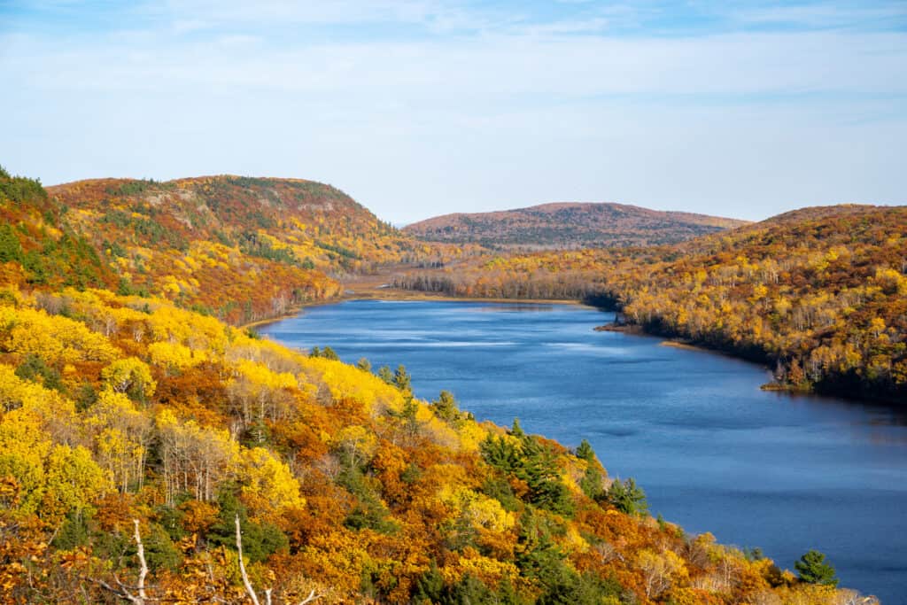
The Escarpment Trail in the
Porcupine
Mountains provides stunning views of fall foliage around the Lake of the Clouds.
©iStock.com/Melissa Kopka
The first incredible hiking trail with stunning views on our list is the Escarpment Trail in the Porcupine Mountains. This must-visit hike is considered difficult and runs for 8.4 miles. It’s an out-and-back trail with an elevation gain of around 1,666 feet. If you’re prepared and experienced, you won’t want to miss this trail. It takes about 4 hours and 10 minutes to complete, sometimes more if you stop to view the scenery. While dogs are welcome, they must be on a leash. According to AllTrails, the best time to hike the Escarpment Trail is from March through October. You can access this trail via 3 trailheads. The views of the water and fall foliage are extraordinary.
Mosquito Falls and Chapel Falls via Chapel Loop

The Mosquito Falls and Chapel Falls via the Chapel Loop is a trail near Munising in Pictured Rocks National Lakeshore.
©iStock.com/alexeys
Continuing our list of the 10 best hiking trails in Michigan with amazing views are the Mosquito Falls and Chapel Falls via the Chapel Loop. This loop is near Munising. It runs for 10.2 miles and takes on average about 3 hours and 41 minutes to complete. While the hiking trail takes nearly 4 hours to complete, you can extend this by making stops at Mosquito Beach and Chapel Beach.
The best time to hike this trail is from April through November. Dogs are not allowed on the trail. You can be fined if you bring your dog. Some hikers recommend bringing a portable charger or two as the trail is long and scenic. You’ll be whipping out your phone every five minutes.
Upper and Lower Tahquamenon Falls

The Upper and Lower Tahquamenon Falls Trail is an out-and-back trail that is about 10.2 miles long.
©Big Joe/Shutterstock.com
Another incredible Michigan trail is the Upper and Lower Tahquamenon Falls Trail. It’s a great way to admire the Upper and Lower Falls. The trail is an out-and-back trail that runs for 10.2 miles. It’s easy to moderately challenging and can take hikers about 3.5 hours to complete. This very popular hiking trail is refreshing and can get muddy. The trail goes through the woods, where you can find a lot of tree roots. Watch your step while hiking! Heads up, this trail does include stairs.
Sleeping Bear Point Trail

You can find many birds on the Sleeping Bear Sand Dunes.
©iStock.com/Gary Ennis
Fourth on our list is the Sleeping Bear Point Trail in Leelanau County. It’s a short, but must-visit hike. The Sleeping Bear Point Trail provides access to Lake Michigan. It’s a moderately challenging trail in the Sleeping Bear Dunes National Lakeshore. It runs for 2.5 miles and has an elevation gain of 301 feet. The best time to visit this loop is from March through October. It’s a popular trail for wildlife viewing and bird watching. Some birds you may see are grasshopper sparrows, red-tailed hawks, piping plovers, and pileated woodpeckers.
Saugatuck Dunes South Trail

A great trail in Michigan is the Saugatuck Dunes South Trail in Saugatuck Dunes State Park.
©Dean Pennala/Shutterstock.com
The Saugatuck Dunes South Trail is a 5.2-mile loop trail in Saugatuck Dunes State Park. This gorgeous trail is a popular place to go bird-watching, so bring a pair of binoculars. On average, the loop takes about 2 hours to complete. It’s a moderately challenging trail perfect to hike from March through October. Many hikers recommend hiking the trail counterclockwise to walk the dunes first. Dogs are allowed but must be kept on a leash.
Pyramid Point Trail

Pyramid Point Trail is a 2.7-mile loop in Sleeping Bear Dunes National Lakeshore.
©Doug Lemke/Shutterstock.com
Also in Michigan is the Pyramid Point Trail which offers a gorgeous lookout point over Lake Michigan. Pyramid Point Trail is in Sleeping Bear Dunes National Lakeshore. It’s a 2.7-mile loop that is easy to moderately challenging. It’s hilly, and to get to the scenic overlook, hikers must hike through a beech-maple forest. On average, the Pyramid Point Trail takes 1 hour and 17 minutes to complete. For great weather, the best time to walk on the trail is May through November. Fall foliage looks stunning here!
Mackinac Island Outer Loop

The Mackinac Island Outer Loop is 8 miles long. To view the iconic Arch Rock, hikers can walk the Arch Rock Trail.
©Hepp’s Photos/Shutterstock.com
Fans of water will love this trail. The Mackinac Island Outer Loop is a great trail for biking, running, and walking. The elevation gain is only 88 feet. The loop runs for 8 miles and surrounds the island. On this trail, you may even see people fishing from rocky points. At the 4-mile mark are restrooms and snacks, perfect for a quick break before continuing on the trail.
Another popular trail on Mackinac Island is the Arch Rock Trail. If you have enough time, add this bonus trail to the list! It’s a 2.1-mile out-and-back trail to the gorgeous Arch Rock. When peering down at the water, it’s hard to believe it’s not the ocean.
Miners Castle Trail
Not all trails have to be super long. An incredible trail in Michigan is the Miners Castle Trail near Munising in the Pictured Rocks National Lakeshore. Miners Castle Trail is a 0.5-mile out-and-back trail with a short elevation gain of 85 feet. It’s very easy and popular. It isn’t uncommon to see other hikers and bird watchers while completing the trail. On average, the trail takes less than 15 minutes to hike. From the upper viewing deck, hikers can enjoy views of the sparkling and clear Lake Superior and Miner’s Castle.
Nordhouse Dunes Loop

The Nordhouse Dunes Loop is a moderately challenging hiking trail with an elevation gain of 357 feet.
©Pat Downes/Shutterstock.com
Another trail on our list of the 10 best hiking trails in Michigan with amazing views is the Nordhouse Dunes Loop. This loop has an elevation gain of 357 feet. It’s a 5.7-mile loop trail near Ludington, Michigan that takes about two hours to complete. The Nordhouse Dunes Loop is considered moderately challenging. It’s a popular trail, so expect to see hikers, wildlife viewers, and campers. The views are remarkable and include a soft sandy beach and tall trees in the forest. Animals you can find on this trail are American bullfrogs, great blue herons, scarlet tanagers, and North American porcupines.
Manistee River Loop Trail

The Manistee River Loop Trail is 19.2 miles long and has an elevation gain of 1,824 feet. It’s in the Manistee National Forest.
©Raccoon posse / Creative Commons – License
Continuing our list is the Manistee River Loop Trail. It’s challenging and long, but worth a try for experienced hikers. According to AllTrails, the Manistee River Loop Trail is 19.2 miles long and has an elevation gain of 1,824 feet. This moderately challenging trail is in the Manistee National Forest and offers gorgeous views. In total, it can take over 7 hours to complete this trail, longer if you stop to take pictures and admire the beauty. This backpacking trail also offers wonderful star-gazing opportunities. While here you can see wildlife like whitetail deer, red foxes, cedar waxwings, and common watersnakes.
The photo featured at the top of this post is © Narrow Window Photography/Shutterstock.com


How to Add Us to Google News


Thank you for reading! Have some feedback for us? Contact the AZ Animals editorial team.