
Nestled within the vast urban sprawl of Los Angeles lies an abundance of breathtaking natural beauty waiting to be explored on foot. From rugged mountain peaks like Mt. Baldy to tranquil coastal paths like Topanga State Park, the City of Angels offers diverse hiking trails that cater to every adventurer’s taste. Whether you’re a seasoned hiker seeking a challenging climb or a nature enthusiast yearning for a serene escape, Los Angeles has it all.
From rugged mountain peaks like Mt. Baldy to tranquil coastal paths like Topanga State Park, the City of Angels offers diverse hiking trails that cater to every adventurer’s taste.
©Chones/Shutterstock.com
In this article, we’ll guide you through the ten best hikes in this vibrant city of L.A., unveiling stunning mountain, coastal and city views.
Lace up your hiking boots, grab your water bottle, and choose a hike in Los Angeles to do this weekend.
1. Runyon Canyon Park
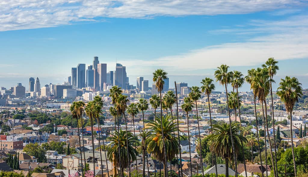
Runyon Canyon is a great park to walk and view the Los Angeles skyline. Nestled at the eastern end of the majestic Santa Monica Mountains in Los Angeles, California, lies the sprawling 160-acre oasis. The Vibe is oh-so-Hollywood with gym bros and models with tiny dogs.
This is the view of downtown Los Angeles from Runyon Canyon Park, California.
©MILA Zed/Shutterstock.com
The Los Angeles Department of Recreation and Parks manages the park at the north end of Fuller Avenue in Hollywood; the southern entrance welcomes hikers to explore the grounds.
You may need to take a few breathers on the ascent to catch your breath and to take selfies at the vantage points throughout (both are necessary). This is perfect for visitors who want an excellent L.A. taste or locals looking for a quick workout.
How to get to Runyon Canyon Park
Mulholland Entrance: This entrance is the northern gateway to Runyon Canyon Park at Mulholland Drive and Pyramid Place. This entrance provides optimal access to the East Trail and a captivating viewpoint that branches off from the northern section of the West Trail. Additionally, it marks the starting point for the paved road traversing the park’s center, ultimately leading to the Vista Entrance (not accessible to private vehicles).
Vista Entrance: This entrance is positioned in the southwest, at the junction of N Vista Street and Runyon Canyon Road, offering an ideal starting point for those embarking on an entire West Trail journey or planning a scenic loop around the park.
Fuller Entrance: Located at the southernmost tip of N Fuller Avenue, it grants expedient entry for those with limited time, specifically directing them to the captivating Inspiration Point.
Park Hours
The park is open daily from dawn to dusk, and access is complimentary. However, some trails may be closed during certain times of the year. To be safe, you should always check the information section on the official website.
Address:
2000 N Fuller Ave, Los Angeles, CA 90046
2. Topanga State Park
Situated between the scenic locales of Calabasas and Santa Monica, Topanga State Park beckons with its captivating vistas of verdant mountains and the majestic Pacific Ocean. If you seek a moderate-intensity hike, this trail is highly recommended.
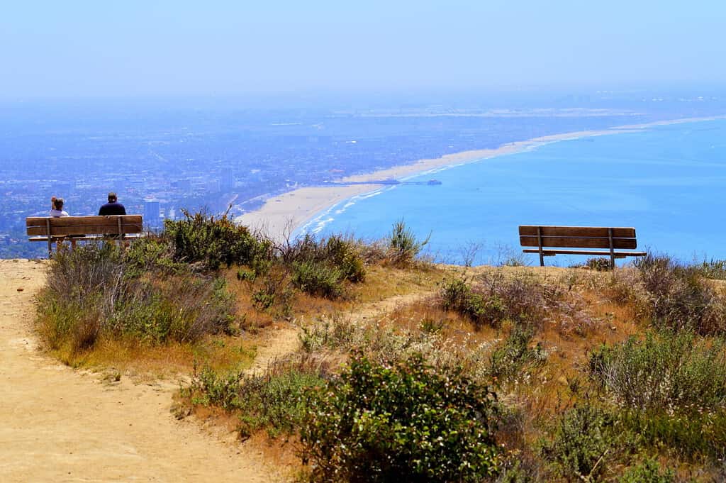
Parker Mesa Overlook on the west side of Topanga State Park, California.
©divanov/Shutterstock.com
Topanga State Park features 36 miles of trails through open grassland, live oaks, and spectacular views of the Pacific Ocean. The park is located entirely within the Los Angeles city limits and is considered the world’s largest wildland within the boundaries of a major city.
The park is bound on the south by Pacific Palisades and Brentwood, west by Topanga Canyon, and east by Rustic Canyon. Numerous geologic formations in the park include earthquake faults, marine fossils, volcanic intrusions, and various sedimentary formations. If you’re looking for a moderate hike, Temescal Canyon Trail.
How To Get to Topanga State Park
From Pacific Coast Highway, travel north on Topanga Canyon Boulevard, pass the post office at the center of “town,” then turn right on Entrada Road.
Keep to the left at every opportunity until you reach the park’s main parking lot (about one mile). From the Ventura Freeway (101), exit at Topanga Canyon Boulevard, drive south over the crest of the mountains and proceed three miles to Entrada Road and turn left.
Park Hours
Parking lot 8:00 am til sunset
Topanga Ranger Line
310-455-2465 x106
Address
20828 ENTRADA ROAD
TOPANGA, CA
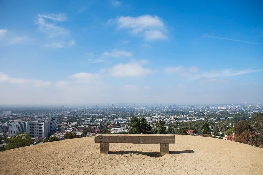
3. The Charlie Turner Trail to Mount Hollywood (Griffith Park)
The Charlie Turner Trail (also sometimes called Mount Hollywood) is the best trail to reach the summit of Mount Hollywood in Griffith Park. Named after a former park superintendent, this trail offers hikers an immersive experience in the park’s natural beauty while leading them to the peak of Mount Hollywood.
Mt Hollywood Hiking Trail, Charlie Turner Trailhead, Los Angeles Park.
©mike7/Shutterstock.com
You’ll traverse a scenic route showcasing 360-degree views of everything from the Verdugo Mountains to the Pacific Ocean, including glimpses of the iconic Hollywood Sign.
On the way up Mount Hollywood, you will pass Captain’s Roost, a rest stop with a fabulous view of the famed Hollywood Sign. The sign, which initially said “Hollywoodland,” first graced Mount Lee in 1923 as part of a campaign for the Hollywoodland Real Estate Development. Today it is an iconic symbol of the movie industry, and tourists can get a good look at it from the Charlie Turner Trail.
After a rewarding hike of approximately 40 minutes, you’ll reach the summit of Mount Hollywood. At this lofty point, bask in the panoramic vistas of the Los Angeles basin, the San Fernando Valley, the distant hills, the captivating downtown skyline, and the Hollywood Sign in all its glory.
How to get to The Charlie Turner Trail
To get to the Mount Hollywood summit, Griffith’s highest peak, pick up the trail at the north side of the Observatory parking lot. Snag a spot in the lot next to the Griffith Observatory. If that lot is too hectic, look for street parking along Observatory Avenue. Both cost $8–$10 per hour. Alternatively, a DASH bus runs up Vermont Avenue daily from 10 am–10 pm for only 50 cents (35 cents with a TAP card).
Park Hours
Parking lot 5 am–10 pm. Hiking trails close at sunset.
Address
2800 E Observatory Ave
4. Mount Baldy
For seasoned hikers seeking a thrilling challenge, the Mount Baldy trail in L.A. County awaits. Towering at 10,068 feet, Mount Baldy proudly claims the title of the highest peak in the stunning San Gabriel Mountains. This epic hike spans approximately 6.5 miles, ascending a staggering 2,300 feet. However, a “cheat” option exists for those seeking a shorter route, a chair lift that shaves off four miles of the journey. While you may forgo the lift during the ascent, it is convenient for the descent unless you’re feeling particularly ambitious.
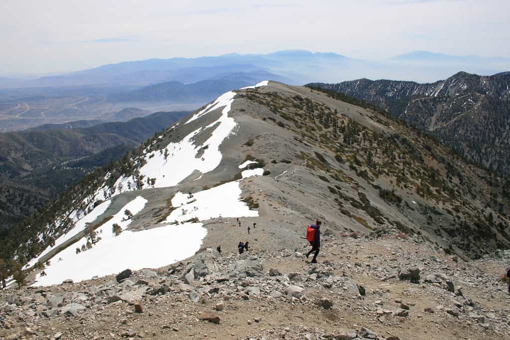
Remember that hiking Mount Baldy can be challenging and is recommended for experienced hikers.
©Daniel Shearly/Shutterstock.com
As you ascend, the absence of trees at the mountain’s summit gives Mount Baldy its name, creating a surreal sub-alpine landscape that is truly awe-inspiring. One highlight along the way is Devil’s Backbone, where hikers are treated to the sensation of traversing a stegosaurus’ spine, with sheer drops on either side. Be sure to pause and soak in the breathtaking views at this remarkable vantage point. Embarking on the Mount Baldy trail promises an exhilarating adventure, inviting you to push your limits and savor the mesmerizing beauty of L.A. County’s highest peak.
Remember that hiking Mount Baldy can be challenging and is recommended for experienced hikers. Always prioritize safety and be prepared for changing weather conditions and steep terrain.
How to get to Mount Baldy
Starting from Los Angeles, take the I-10 East freeway towards San Bernardino. Take the exit for Mountain Avenue in Upland and turn right onto Mountain Avenue. Continue on Mountain Avenue, which will eventually turn into Mount Baldy Road. Please stay on this road as it winds up into the mountains. Follow Mount Baldy Road for approximately 12 miles until you reach the Mount Baldy Visitor Center. A parking lot is available here, but it can get crowded during peak times. From the visitor center, you have a couple of options for the hike. You can take the Ski Lifts (which operate during specific times) to shave off some distance, or you can choose to hike the entirety of the trail.
Park Hours
Mount Baldy is open during daylight Hours. Planning your hike during daylight hours is essential, as navigating the trails in darkness can be dangerous. Check the sunrise and sunset times for the day of your visit and plan accordingly.
Address
6777 Mount Baldy Road,
Mount Baldy, CA 91759,
5) Bridge To Nowhere
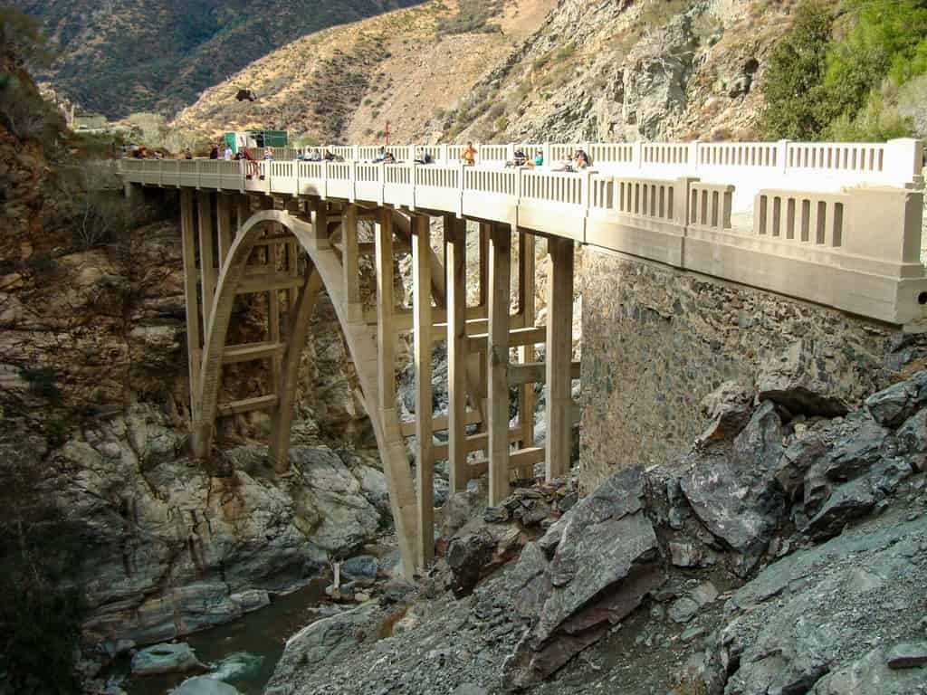
This 10-mile hike traverses rivers and canyons, promising breathtaking sightseeing opportunities and an immersive outdoor experience.
©PILACAS/Shutterstock.com
The Bridge to Nowhere is an arch bridge built in 1936 north of Azusa, California, United States, in the San Gabriel Mountains. It spanned the East Fork of the San Gabriel River and was meant to be part of a road connecting the San Gabriel Valley with Wrightwood, California.
This 10-mile hike traverses rivers and canyons, promising breathtaking sightseeing opportunities and an immersive outdoor experience. Along the way, you’ll encounter refreshing river crossings, which provide a welcome respite from the summer heat. There’s even an option for the daring adrenaline junkies to join an outfitter and partake in bungee jumping off the summit’s bridge. It’s important to note that a wilderness pass is required to hike the trails, and caution should be exercised during winter when flash flooding can pose significant risks.
Always stay informed about the weather conditions and consider alternative options when necessary. If you embark on this adventure during the summer, ensure you carry ample water, as the hike is long and takes you through remote areas. So, gear up, stay hydrated, and get ready for an unforgettable experience that blends natural beauty with a touch of adrenaline.
How to get to Bridge To Nowhere
Start by heading towards Azusa, a Los Angeles County, California town. From Azusa, take the CA-39 N/Azusa Ave northbound. Continue on CA-39 N for approximately 12 miles until you reach East Fork Road. Take a left onto East Fork Road. Follow East Fork Road for about 6 miles until you reach the parking area at the trailhead. Note that the road becomes rough and unpaved, so ensure you have a suitable vehicle for this terrain. Park your car in the designated parking area and gather your hiking gear and supplies.
Park Hours
The Bridge to Nowhere hike has a variety of park hours as it is located within the Sheep Mountain Wilderness area of the San Gabriel Mountains, part of the Angeles National Forest. It is recommended that you only hike during daylight hours.
Address
Sheep Mountain Wilderness Area:
Azusa, CA 91702
6. Malibu Creek State Park
Nestled a mere 25 miles from downtown Los Angeles, Malibu Creek State Park offers many outdoor activities and breathtaking natural beauty. This expansive park provides opportunities for hiking, fishing, bird watching, mountain biking, rock climbing, and horseback riding, ensuring there’s something for every outdoor enthusiast.
Apart from its natural wonders, Malibu Creek
State Park
holds significant cultural importance. For centuries, it was a center of Chumash Native
American
life.
©JohannaZender/Shutterstock.com
The focal point of the park is the stunning 14-mile Malibu Creek, which serves as the main watercourse of the Santa Monica Mountains, culminating at the picturesque Malibu Lagoon. Along the 15 miles of streamside trails, visitors are treated to enchanting oak and sycamore woodlands and chaparral-covered slopes. Following the trail along Malibu Creek reveals a visual feast of volcanic rock gorges, tranquil pools, and awe-inspiring vistas of the Las Virgenes Valley and Malibu Canyon.
Cultural Importance
Apart from its natural wonders, Malibu Creek State Park holds significant cultural importance. For centuries, it was a center of Chumash Native American life. One of the park’s notable landmarks was the Sepulveda Adobe, built in 1863 on land that was once part of a Spanish land grant. Although the adobe was unfortunately destroyed in the 2018 Woolsey fire, it was meticulously restored in 2003. Another historic site within the park is the Mott Adobe ruins. It was built by Johnny Mott, a renowned Los Angeles attorney, in the early 1900s. President Herbert Hoover was among the notable guests who frequented the Mott Adobe. Today, only the striking stone fireplace remains a testament to its past.
Before opening to the public in 1976, Malibu Creek State Park was a favored filming location for countless movies and T.V. shows. The park’s land holdings were predominantly acquired from 20th Century Fox. They utilized the former Crags Country Club for on-location filming. Iconic productions such as the original Planet of the Apes movie and the beloved MAS*H TV show were among the many filmed here, leaving behind a rich cinematic legacy that continues today.
Malibu Creek State Park invites visitors to immerse themselves in its natural wonders, explore its fascinating history, and relish that they are treading upon the same grounds that once captivated filmmakers and audiences alike.
Popular trails and hikes:
- Rock Pool (easy)
- Century Lake (accessible)
- M*A*S*H site (moderate)
- Lookout Trail (moderate)
How to get to Malibu Creek State Park
The park is four miles south of Highway 101 on Las Virgenes/Malibu Canyon Road. From the 101 exit on Las Virgenes Road. Go south on Las Virgenes Road (toward the ocean). Continue straight. The park entrance will be on the right, a little past the Mulholland Drive intersection.
Park Hours
The gates are open from 8 am-10 pm.
Address
1925 Las Virgenes Road, Calabasas, CA 91302
7. Hollywood Sign Hike

©PR Image Factory/Shutterstock.com
The most popular hike on this list leads to unobscured views of one of the west coast’s most iconic landmarks, the Hollywood Sign. There are several routes, each providing a different perspective of the sign and ranging in length and difficulty. See below for two options.
Brush Canyon Trail:
Gear up with your Hydro Flask and dri-fit cap, as the Brush Canyon Trail is perfect for a day hike. As you ascend, you’ll be rewarded with a viewing area just behind the Hollywood Sign. Embrace the Hollywood spirit on this 6.4-mile loop and make a fun side trip to the Bronson Caves, famous for storing the Batmobile in the 1960s Batman TV series.
Address
3200 Canyon Drive, Griffith Park, Los Angeles, CA 90068
Hollyridge Trail
Considered one of the easiest ways to reach the sign, the Hollyridge Trail promises a relatively quick hike covering 3.5 miles lasting only about an hour. Be mindful of parking restrictions and the trail’s popularity, which may require additional logistics time. The Hollywood Sign will come into full view within minutes of starting the hike, making the extra effort.
Address
3100 Beachwood Drive, los angeles.
8. Escondido Falls Hike in Malibu
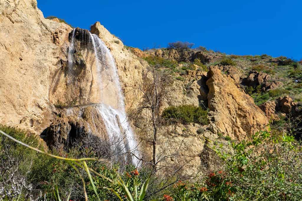
Views of the Southern California waterfall, Escondido Falls, after heavy rainfall in Los Angeles.
©Adam Mustafa/Shutterstock.com
Discover the enchanting allure of Escondido Falls, a premier coastal hike nestled in the scenic beauty of Malibu. This hiking trail offers a pleasant and manageable 4-mile round trip with an elevation gain of 300 feet, granting access to one of Southern California’s most captivating waterfalls.
The waterfall boasts a breathtaking three-tiered cascade, with the first tier easily accessible. However, exercise caution if you intend to explore the two upper tiers as the terrain becomes trickier, necessitating steady footing on loose dirt.
How to get to Escondido Falls
Parking for this hike is in the small lot on Winding Road off Pacific Coast Highway or simply on Highway 1 itself if the lot is full, as it was for us when we journeyed there. I recommend putting “Visitor Parking for Escondido Canyon and Falls” into your Google Maps, which should take you to the parking lot on the corner of Winding Road and PCH. From here, you merely start walking up the road.
Park Hours
Sunrise to Sundown
Address
Escondido Canyon Trail, Malibu, CA 90265
9.) Solstice Canyon Loop
Experience this 3.0-mile loop trail near Malibu, California. Generally considered a moderately challenging route, it takes an average of 1 h 34 min to complete. This area is trendy for hiking, so you’ll likely encounter other people while exploring. The trail is open year-round and beautiful to visit anytime, especially in the spring when all the wildflowers bloom. Dogs are welcome but must be on a leash.
The Solstice Canyon Trail sits in the enchanting Santa Monica Mountains. This well-trodden path offers both seasoned adventurers and leisurely explorers a delightful journey through mostly shaded canyons, immersing them in picturesque vistas.
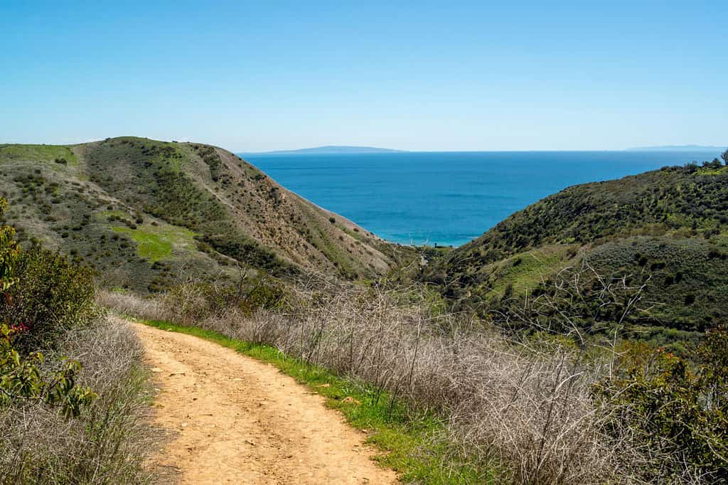
Generally considered a moderately challenging route, it takes an average of 1 h 34 min to complete.
©GreggieG/Shutterstock.com
Among the many attractions along the way, you’ll encounter the oldest standing stone building in Malibu, a charming small waterfall accompanied by a serene creek, and a collection of fascinating ruins, including that of a mansion, evoking the area’s rich history.
The Journey
Follow the service road from the gate that gracefully trails along the creek’s right side. As you advance, you’ll veer onto a dirt road leading to the Santa Monica Mountains Conservancy buildings. From there, take the Rising Sun Trail, an exhilarating ascent up the ridge offering splendid ocean views, before descending into the intriguing Tropical Terrace. These are the remains of a 1960s home that met its fate in a fire in 1982. Amidst this enigmatic setting, you’ll encounter exotic plants, delightful pools, a captivating 30-foot waterfall, and even a hidden statue of the Virgin Mary, adding an air of mystery to your adventure.
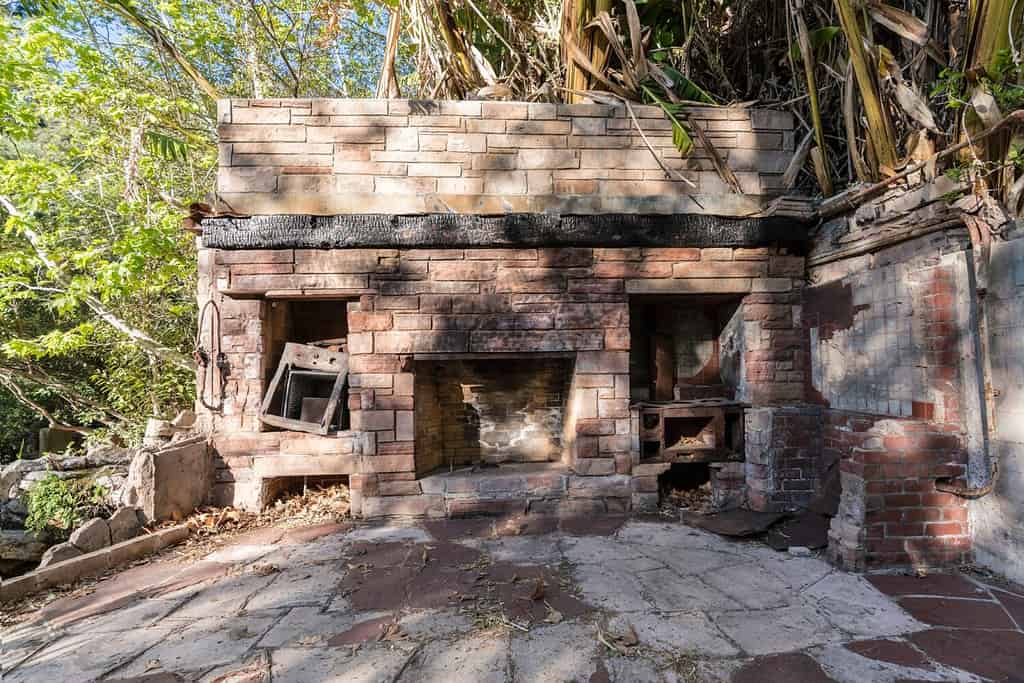
Overgrown ruin of fire-damaged home at the popular Solstice Canyon nature area in the Santa Monica Mountains National Recreation Area near Malibu, California.
©trekandshoot/Shutterstock.com
For those seeking an extra dose of thrill, an incredibly steep trail leads above the waterfall, where charming pools await. Be cautious as you navigate the rocky terrain.
The return route presents a pleasant, shady service road parallel to the stream, providing a relaxing stroll amidst nature’s wonders.
How to get to Solstice Canyon Loop
Head north on Pacific Coast Highway from Malibu Canyon Road to Corral Canyon Road and turn right. About a quarter mile up, you will see the gated entrance to Solstice Canyon.
Park Hours
Sunrise to Sunset
Address
Solstice Canyon Education Shelter, TRW Loop Trail, Malibu, CA 90265
10. Point Mugu State Park
Point Mugu State Park beckons with its captivating landscapes, encompassing five miles of awe-inspiring ocean shoreline. The park is adorned with rocky bluffs, sandy beaches, dunes, rugged hills, and expansive grassy valleys adorned with sycamores, oaks, and native walnuts. Immerse yourself in nature as you traverse over 70 miles of diverse hiking trails that weave through this picturesque wonderland. The beach area offers swimming, body surfing, and surf fishing opportunities, providing a perfect blend of coastal delights.
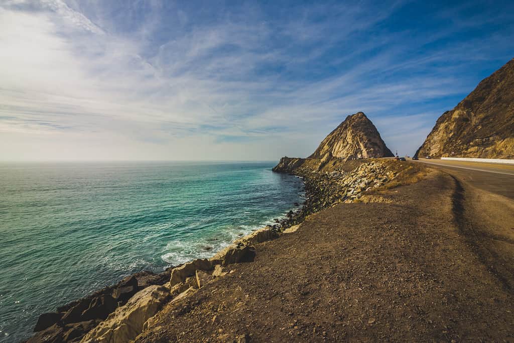
Rocky shoreline view of the Point Mugu Rock along Pacific Coast Highway, Point Mugu, California.
©Andy Konieczny/Shutterstock.com
Adding to its allure, Point Mugu State Park includes the breathtaking Boney Mountains State Wilderness Area, characterized by its jagged pinnacles that stand tall and proud.
For those eager to explore this natural paradise, reach the beach by driving 15 miles south from Oxnard on Highway One. Please be aware of the following parking fees:
- All-day parking: $12.00 per car per day
- 3 hours: $9.00 per car
- 2 hours: $6.00 per car
- 1 hour: $3.00 per car
You’ll find options suitable for various preferences and fitness levels among the park’s popular hikes and trails. One example is the leisurely Grotto Trail. This moderately challenging Mugu Peak Trail and the easy-going Scenic and Overlook Trails Loop.
How to get to Point Mugu State Park
Remember that bicycles and dogs are prohibited within the Boney Mountain State Wilderness Area when accessing Point Mugu State Park via the Old Cabin Trail from the National Park Service’s Rancho Sierra Vista. So, come prepared for a pet-free and pedal-free adventure amidst the natural splendor of Point Mugu State Park.
Address
9000 West Pacific Coast Highway, Malibu, CA 90265
The photo featured at the top of this post is © PR Image Factory/Shutterstock.com


How to Add Us to Google News


Thank you for reading! Have some feedback for us? Contact the AZ Animals editorial team.