
From the massive changes in elevation to the vast expanses of desert flats, the foreboding terrain of Death Valley tells the dramatic story of its past. Hundreds of millions of years of earth-shattering events went into its formation, shaping the valley and the surrounding region into the one we see today.
In this article, we’ll find out about the intense and ancient formation of Death Valley and look at some of the valley’s most interesting characteristics. We’ll also highlight some of the plants and animals that have adapted to survive the harsh environment there. Some of them exist nowhere else in the world!
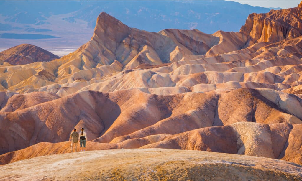
The rugged terrain in and around Death Valley, with all its extremes, gives clues to the incredible story of its formation.
©Dan Sedran/Shutterstock.com
How Did Death Valley Form?
The geological story of Death Valley’s formation is extremely long and tumultuous. Though the oldest rocks in the valley date back at least 1.7 billion years, it’s difficult to glean much information about their history. These rocks have undergone such drastic transformations throughout their existence that their origins are pretty unclear. We do know, of course, that the Earth was moving and changing back then just as it is today.
It isn’t until much later in the geological record — about 1.2 billion years later — that we gain a better understanding of Death Valley’s ancient origins. By examining limestone and sandstone rocks in the surrounding mountains, geologists have determined that the area was once a warm, shallow sea that would have supported many prehistoric animals. This sea changed slowly over the next 200 million years, receding as tectonic plates gradually folded and cracked the planet’s crust. Mountains formed, aged, and eroded, weakening the Earth’s crust over time.
Eventually, it started to give way. About 65 million years ago, during the Earth’s Tertiary Period, intense volcanic activity shaped the new, rugged landscape. Massive eruptions covered the area with ash and cinder, and lava flows formed new rock across the surface. The highest points of pressure buildup beneath the crust gradually migrated to the west, resulting in the formation of long volcano chains.
Eventually, about 3 million years ago, the compression and violent volcanism of the earth settled down and the Death Valley we know today began to develop. The plates that birthed the area’s mountains began to pull apart, allowing fractured blocks of land to slide downward along fault lines. As the land sank between the Amargosa Mountains and the Panamints, the valley began to take shape. The story doesn’t end there, though — the valley floor continues to sink to this day!
Where Is Death Valley?
The incredible Death Valley lies to the east of the Sierra Nevada mountains, along California’s border with Nevada. It is part of the Great Basin, which encompasses large portions of Nevada and Utah, as well as parts of Oregon, Idaho, Wyoming, and Eastern California. In addition to Death Valley, the Basin includes such important landmarks as the Great Salt Lake, the Humboldt River, and Lake Tahoe. Owing to its long and complex geological history, the region is also home to some extreme changes in elevation.
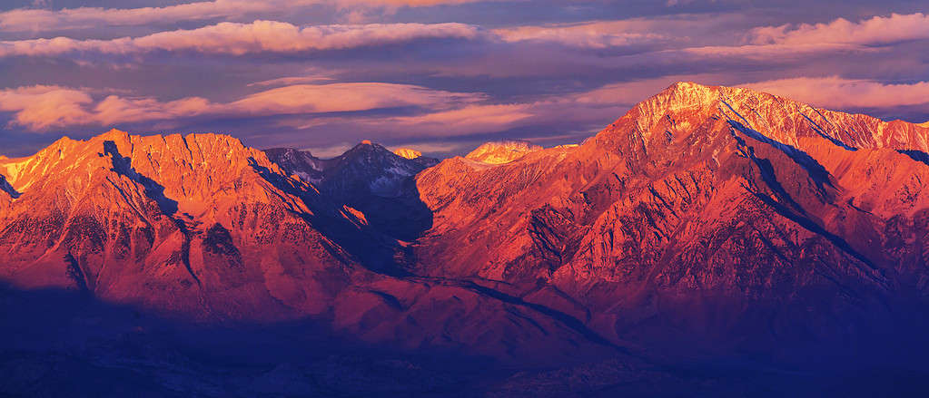
The Sierra Nevada mountain range forms the western border of the Great Basin, which encompasses many Western U.S. states and, of course, Death Valley.
©Galyna Andrushko/Shutterstock.com
Death Valley’s lowest point, Badwater Basin, is more than just a dip in the landscape of the Great Basin. Sinking to 282 feet below sea level, it is the lowest point in elevation in the entirety of North America. A true testament to the intense geological history of the region, the lowest and highest points on the continent sit within 100 miles of each other. The nearby Mount Whitney, part of the Sierra Nevada range, towers 14,505 feet over the surrounding landscape. That’s a massive elevation change over such a short distance!
What Lives There?
While its name may suggest otherwise, Death Valley is full of life. Myriad plant and animal species have adapted to thrive in the incredibly hot and arid desert that lies between the surrounding mountains. It’s truly a wonderland of desert diversity! Some species are even endemic to the valley and exist nowhere else in the world.
Plants of Death Valley
More than 1,000 species of plants take root in and around the valley, having adopted a number of strategies to cope with the extreme environment. Some plants just bear the intense heat and drought. The desert’s mesquite trees send long, stout roots deep below the surface to access groundwater while shallow-rooted cacti store rainwater in their stems at any opportunity.
Other plants, like the region’s many desert wildflowers, wait out the harshest parts of the year, only sprouting when conditions are gentler. Some, like the Panamint daisy (Enceliopsis covillei) and the Holmgren’s lupine (Lupinus holmgrenianus), only exist within the boundaries of Death Valley National Park. Rarely, when spring conditions are right, the wildflowers may even create a brief sea of bright color that engulfs the broad desert flats. The stunning colors and scent of nectar attract pollinators far and wide, ensuring seed production for the following year.
The creosote bush (Larrea tridentata), a staple member of most regional desert plant communities, grows prolifically in and around Death Valley. It competes fiercely for the limited resources in its harsh environment, thriving in the arid heat and providing cover for desert animals. The plant’s specially adapted waxy leaves limit evapotranspiration and allow it to survive in some of the hottest places on Earth!
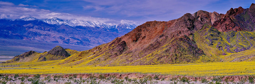
Believe it or not, this is Death Valley! When the wildflowers bloom en masse, they transform the barren valley into a sea of color.
©Doug Meek/Shutterstock.com
Animals of Death Valley
These pollinators aren’t just visitors, though. Many reside in the desert year-round alongside over 400 other species of animals! Like the plants, the valley’s animals have also adapted special ways to survive the dry heat. The desert bighorn, for example, can travel for several days without drinking any water. The kangaroo rat (Dipodomys deserti) doesn’t even need to drink water at all! Instead, it derives all the moisture it needs from the plants it feeds on. While many birds simply leave the valley during the summer, the greater roadrunner (Geococcyx californianus) has adapted to withstand the high temperatures. With body temperatures that naturally run as high as 104 °F, they relish the seasonal heat.
Some animals deal with the soaring temperatures by avoiding them altogether. Desert tortoises, for example, spend the hottest days of the year underground. The earth insulates the tortoises from the scorching temperatures above, allowing them to conserve resources. The same strategy protects them in the winter when temperatures drop toward and below freezing. They often spend most of their lives in their burrows!
Surprisingly enough, there are even fish that live in the desert near Death Valley. One cave, known as Devil’s Hole, hosts a small population of one fish species that exists nowhere else on Earth. How they came to exist only in the cave is still uncertain. While the high temperature and low oxygen content of the cave’s water would make even the toughest tropical fish struggle, it’s the only home the Devil’s Hole pupfish (Cyprinodon diabolis) knows.
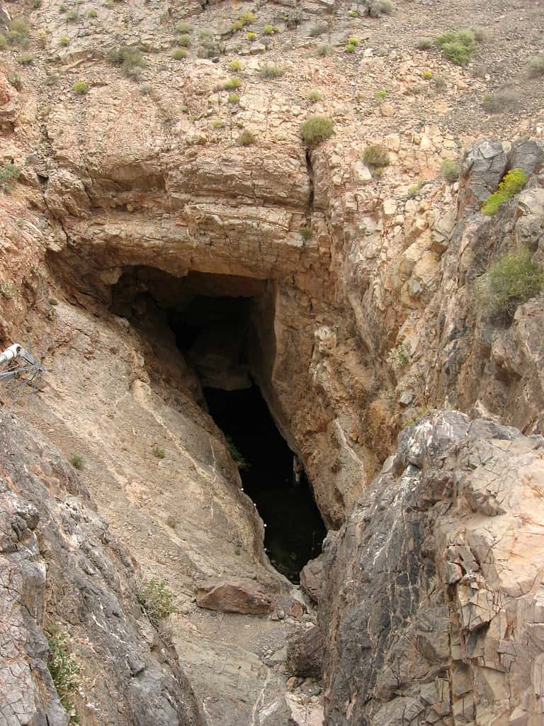
Devil’s Hole, pictured above, is a deep underwater cave that is home to the world’s only population of the
Devil’s Hole pupfish
.
Is Death Valley the Hottest Place in the World?
Like most of the great basin, Death Valley is hot and arid. Temperatures regularly reach 110 °F during the summer, and sometimes soar above 120 °F! With temperatures like these, it probably isn’t surprising that many believe the valley to be the hottest place on Earth in the summer months. But would you believe that there are even hotter places?
In 1913, the United States Weather Bureau documented a record high temperature of 134 °F (56.7 °C) at the valley’s Furnace Creek. For decades, this reading stood as the highest ambient air temperature ever recorded on Earth. In 2011, however, researchers taking readings from NASA’s MODIS instruments mounted aboard a pair of satellites noted that some arid regions were regularly much hotter! One area in the Sonoran Desert, along the U.S. border with Mexico, once reached a scorching 177.4 °F (80.8 °C). In an astonishing coincidence, the Lut Desert in Iran, now regarded as the hottest place on Earth, reached the exact same temperature just one year prior.
Mystery of the Moving Stones
A dried-out lake in a remote area of Death Valley National Park is home to a mysterious phenomenon that has puzzled researchers for years. Ordinary rocks, as they fall onto the Racetrack Playa from the surrounding mountains, seem to take on a life of their own. As if by magic they travel great distances across the flat ground, leaving trails behind them as they do. Some of these stones are quite large and weigh hundreds of pounds!
Nobody had ever witnessed the stones move and over the decades, the phenomenon captured countless imaginations. From magnetic fields and hurricane winds to dust devils and, of course, aliens, there have been many hypotheses for the stones’ migration. Several of the more plausible hypotheses have been tested, returning inconclusive results at best. It wasn’t until very recently that a team of researchers uncovered the truth.
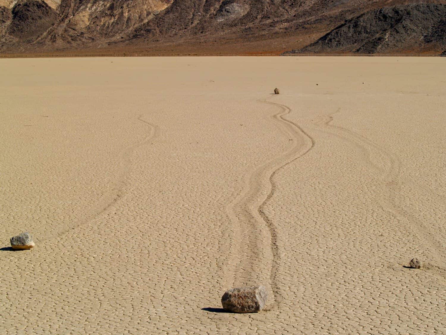
The mysterious sailing stones of Death Valley National Park have puzzled researchers for nearly a century.
©Shiamson/Shutterstock.com
How the Sailing Stones Sail
Rather than hoping to see the stones move in person, the team decided to monitor the stones remotely. After all, some of the stones have remained stationary for more than a decade at a time. In 2011, they outfitted 15 stones with motion-detecting GPS equipment and dispersed them across the lakebed in preparation for a long wait. Ironically, just two years later, the researchers became the first eyewitnesses to the stones’ travel.
They discovered that it takes a very specific set of wintry circumstances to make the stones move. First, the lakebed must fill with enough water to form a pond that partially covers the rocks. Then, as the temperature drops over the course of the night, the surface of the pond must freeze. As the sun warms the water the following morning, the ice sheet breaks apart into large pieces that then drift across the pond’s surface in the wind. The moving plates of ice, as they travel, nudge the stones across the soft, muddy lakebed.
This discovery put to rest a question that focused research efforts and perplexed scientists for nearly 100 years. What’s more, is that the circumstances that cause the stones to move are much gentler than expected. It turns out that the wind only needs to blow at about 10 miles per hour to move the ice. Additionally, the ice plates that move even the largest of the stones only need to be about a quarter-inch thick!
The photo featured at the top of this post is © iStock.com/Dmitri Zelenevski


How to Add Us to Google News


Thank you for reading! Have some feedback for us? Contact the AZ Animals editorial team.