
California is one of the largest and most influential states in the country. And its borders are interesting; except for the Colorado River boundary in the southeast, they form straight lines that ignore the natural topography. It’s also an enormous state with a population that has strong ideological differences between its urban and rural areas. This has led some people to suggest that California be divided into two, three, or even six states! There’s a method to the madness of California’s borders, though. Join us in exploring how California got its unique shape!
©EmLion/Shutterstock.com
How Did the United States Get Its Land?
Let’s do a quick overview of how the country acquired the territory that makes up the 50 states. The history of how the U.S. took over this territory helps us understand how California’s boundaries were drawn.
East of the Mississippi
The United States started with 13 original colonies founded by the British Empire on the continent’s eastern seaboard, starting at Jamestown, Virginia. After Britain defeated France in the Seven Years’ War in 1763, the land between the Appalachian Mountains and the Mississippi River was added to the empire. The United States claimed all this territory in the treaty that ended the Revolutionary War in 1783. Canada declined an invitation to join the Revolution, so it remained a British colony. Spain ceded Florida to the United States in 1821. This was due to difficulties in funding, populating, and controlling this part of their empire. They chose instead to focus on maintaining their power in more valuable colonies such as Cuba and the Philippines.
The Mississippi River formed the first western border of the United States.
©iStock.com/Willard
The Midwest
France controlled Louisiana and the outlet of the Mississippi River to the Gulf of Mexico. President Thomas Jefferson sent envoys to Emperor Napoleon to buy the port of New Orleans. He wanted American farmers and manufacturers to have unobstructed access to international markets. Even though the U.S. Constitution had no provision for acquiring more land, Jefferson decided to do it anyway. He believed that otherwise, war with France would be inevitable, as they might limit American access to the ocean.
Napoleon surprisingly sold the entire Louisiana Territory to the U.S. in 1803. It included most of the land that is today the American Midwest, from the Mississippi to the Rocky Mountains and from Canada to the Gulf of Mexico. France was embarking on an expensive war of conquest in Europe. They decided to get funds out of American territory rather than spend money trying to defend it.
While buying New Orleans, the U.S. unexpectedly doubled its size with all of France’s mainland territory.
©Kevin Ruck/Shutterstock.com
The Northwest
Sacagawea, a Native American mother, guided American explorers Lewis and Clark through the country’s new territory to the northwest in a search for a river route to the Pacific Ocean. This journey was the basis for American claims to the area that is now Washington, Oregon, Idaho, Montana, and Wyoming. The British claimed the same territory, while some Americans wanted to annex all of what is today British Colombia, Canada. Ultimately, the boundary between the United States and Canada was set by a treaty with British colonial authorities. By extending the 49th parallel boundary between the U.S. and Canada east of the Rockies across to the Pacific Ocean, each side got about half of the territory they were claiming.
American exploration of the Northwest laid a basis for the country to claim that territory.
©iStock.com/AlbertPego
The Southwest
Today’s Southwestern United States was all part of Mexico after it got its independence from Spain in 1821. Mexico allowed American citizens to settle in Texas, which was lightly populated. But as Mexico tried to impose taxation on them and would not allow slavery, they revolted and declared the independent Texas Republic in 1836. Texas later decided to join the United States. This prompted the U.S. war with Mexico from 1846-1848 over boundary disputes with Texas. The United States took control of about 55% of Mexico’s territory after the war – territory that became the Southwestern states of the United States. Six years later, to gain a favorable railroad route, the U.S. purchased additional territory from Mexico. This was called the Gadsden Purchase and was added to Southern Arizona and New Mexico.
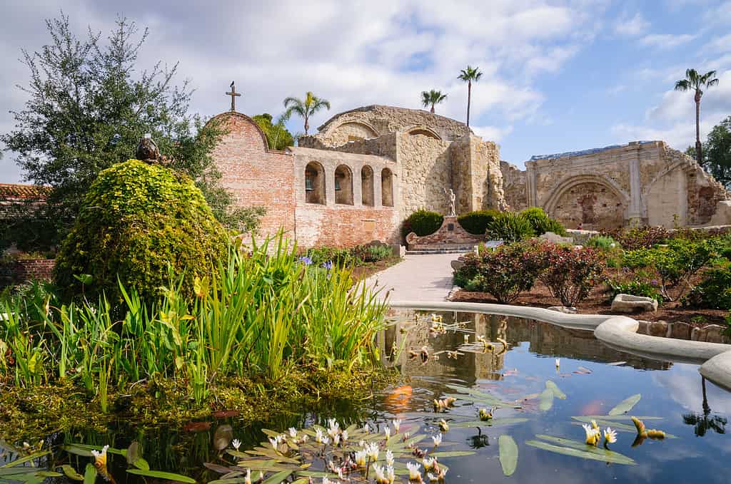
California’s culture shows its Spanish roots, as seen in the Mission of San Juan Capistrano’s architecture.
©Zack Frank/Shutterstock.com
Alaska and Hawaii
Alaska was purchased from Russia in 1867 for just two cents an acre. The Tsarist government could not afford to maintain and defend a territory so far from their European center of power, so they decided to sell it to the still developing and non-threatening United States as a counterweight and buffer to the British Empire in neighboring Canada.
Hawaii was an independent Polynesian monarchy in a strategically commanding position in the center of the Pacific Ocean. American missionaries and plantation owners set up shop there, with sugar being a particularly valuable export. When the U.S. Congress passed protectionist legislation that would have imposed a tax on foreign agricultural products (like Hawaiian sugar), American business people in the islands staged a coup, then applied for annexation to the United States in 1898.
In 1959, Hawaii became the 50th state admitted to the Union.
©iStock.com/SergiyN
The California Republic
Was California ever an independent country? It’s a reasonable question since the state flag includes the inscription “California Republic.” The answer is “yes” and “no.” In 1836 (the same year Texas declared its independence from Mexico), a regional legislator in California named Juan Alvarado launched a coup with assistance from American frontiersmen. They captured Monterey, the capital, and announced the California Republic, complete with its own constitution and flag. The new country was not recognized by Mexico or the United States, though, and lasted only 25 days. It ended in a compromise that resulted in Alvarado becoming governor of the reorganized territory, still under Mexican rule.
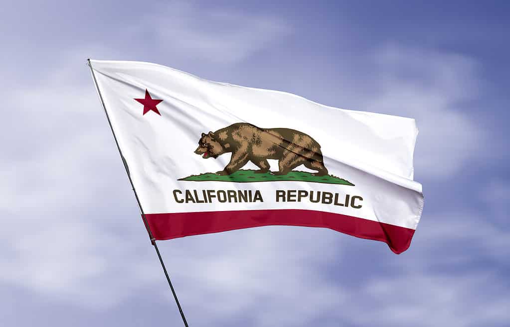
The state flag of California commemorates the short-lived California Republic.
©iStock.com/Matthew Starling
American Interest in California
American citizens had been trickling into California for a century before acquiring the territory. New England whaling ships traveled around the southern tip of South America and plied their trade in the Pacific. They were attracted to California for the plentiful pods of whales off its coast, and some of them set up businesses permanently in port cities. Over time their families blended with Spanish and Mexican families to form a mestizo business and ruling class.
The trickle of settlers to California became a flood after gold was discovered there in 1848 just 9 days before the United States acquired the territory from Mexico. Thousands of so-called ’49ers moved to the state the following year to stake their claim. Some struck it rich, others didn’t. But either way, a large number of them chose to make California their home.

The discovery of gold in California influenced the territory’s settlement patterns and its borders.
©iStock.com/Kaszojad
California’s State Borders
Statehood Application
California’s path to statehood was very fast, no doubt with the understanding that this prosperous and independent-minded territory could easily try to break away as a separate country if the powers that be back in Washington D.C. gave them too much trouble. California applied for statehood in 1849, just one year after the U.S. acquired the territory. There was heated debate in the U.S. Congress, which was divided over slavery and rapidly heading toward the Civil War. Nonetheless, California was able to join the Union as a free state in 1850.
Borders with Oregon, Mexico, and Arizona
Statehood required defining the borders, which happened at a constitutional convention in Monterey in 1849. For the northern and southern borders, the question was already settled. The northern border was the old international border between Mexico and Oregon, and the southern border was the new border between Mexico and California, which had been settled in the treaty of 1848. California just didn’t have any legal standing to claim more territory than that to its north or south. In the southeast, the Colorado River formed a natural boundary between California and Arizona, which didn’t become a state until 1912.
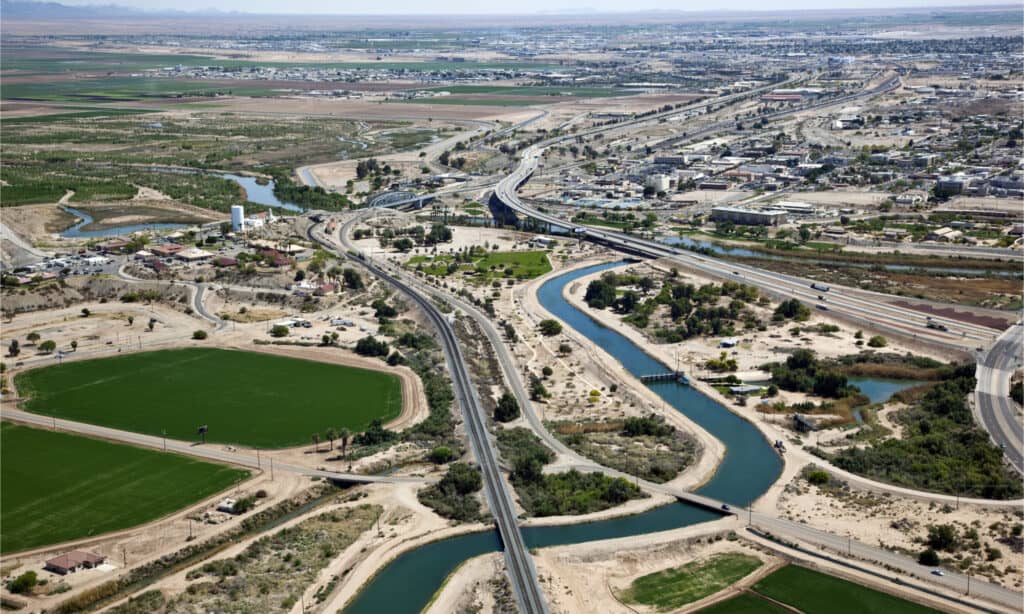
An aerial view of Yuma, Arizona shows the Colorado River, which forms the Arizona-California border.
©Tim Roberts Photography/Shutterstock.com
The Border with Nevada
California might have been much bigger if history had turned out a little differently. One faction at the convention wanted to lay claim to the entire Utah Territory, which at the time included most of Nevada, all of Utah, and portions of Wyoming and Colorado. Another faction argued the border should be drawn just east of the Sierra Nevada Mountains, because such a large territory would be too hard to govern, especially with a large number of Mormons settling in Salt Lake City and drawing up their own plans for a new state to be called Deseret. And besides that, the U.S. Congress would be unlikely to agree to such a mega-state.
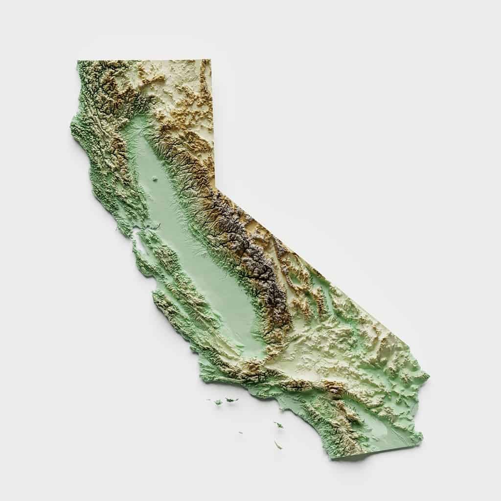
Ultimately it was decided to set the northern part of the border with the Utah Territory (later the state of Nevada) along the 120th meridian. The southern portion of the border was set as a diagonal starting at 120° longitude, 39° latitude, and ending at the Colorado River at 35° latitude. From looking at a terrain map of California, it’s clear that these borders allowed the state to keep control of the entire vast, agriculturally fertile Central Valley as well as a large portion of the mineral-rich Sierra Nevada Mountains, where, over time, over 10,000 gold mines were established. And that helps explain how California got its unique shape.
California’s borders allowed it to retain the vast Central Valley, as well as the Sierra Nevada Mountains.
©David A Litman/Shutterstock.com
Breaking Up California
What if California Became Independent?
Since its admission to the Union as the third largest state in land area, there have been over 220 proposals to divide it into multiple states as well as ideas for breaking it away from the United States as a separate country. If California did become a country, it would have the 5th largest economy in the world, after the United States, China, Japan, and Germany. Its population of 39.2 million people would rank it 38th in the world, ahead of Australia and just behind Canada. Such ideas are dead in the water, though, as the United States already decided in the Civil War that states do not have the right to leave the Union and would be compelled by Federal authorities to stay.
What About 2, 3, or 6 Californias?
Dividing into separate states is another story, though. This already happened peacefully when Maine split away from Massachusetts and West Virginia split from Virginia. Some of the reasons that have been proposed for dividing California are that the state is too big to govern, that the cultural and political differences between the northern and southern parts of the state and urban and rural parts are too great, and that its population is not well-represented in Congress with only two U.S. Senators. Splitting into additional states would give each state its own couple of Senators. Past proposals have suggested dividing California into anywhere from two to six states. One of the most recent proposals suggested a division into Northern California, Southern California, and California (reduced to a strip of left-leaning coastal urban areas).

An area of tension in California is differences between urban Los Angeles and small rural communities.
©iStock.com/choness
Will California Keep Its Shape?
It’s part of the California lifestyle to stay in shape, and that goes not only for the people but for the state itself. No matter how many proposals there have been to change the state’s borders, none of the arguments have been compelling enough to motivate Californians and their politicians to go through the grueling political process and the administrative nightmare that would be necessary to make partition a reality.
Even if there were a consensus in the state, it’s far from likely that the representatives of enough other states in the U.S. Congress would approve a change to the status quo that might upset the country’s political balance, give even more power to California, and set off a domino effect of endless redrawing of other states’ boundaries. What’s more likely is that Californians will go on complaining about one another but still find ways to work together to make themselves and their state successful. And we have to say, that’s actually a pretty practical example for the whole country.

California’s diverse people and perspectives are part of what makes it strong and successful.
©fizkes/Shutterstock.com
The photo featured at the top of this post is © Angr / CC BY-SA 3.0 – License / Original


How to Add Us to Google News


Thank you for reading! Have some feedback for us? Contact the AZ Animals editorial team.