
Though famous for its deserts and dry climate, Arizona is a state with diverse geography, including mountain ranges and even an active volcano field. Arizona’s lowest point is found in one of the state’s most famous natural features. And discovering where that is can be a great way to sample Arizona’s fascinating geographic history.
Arizona Geology
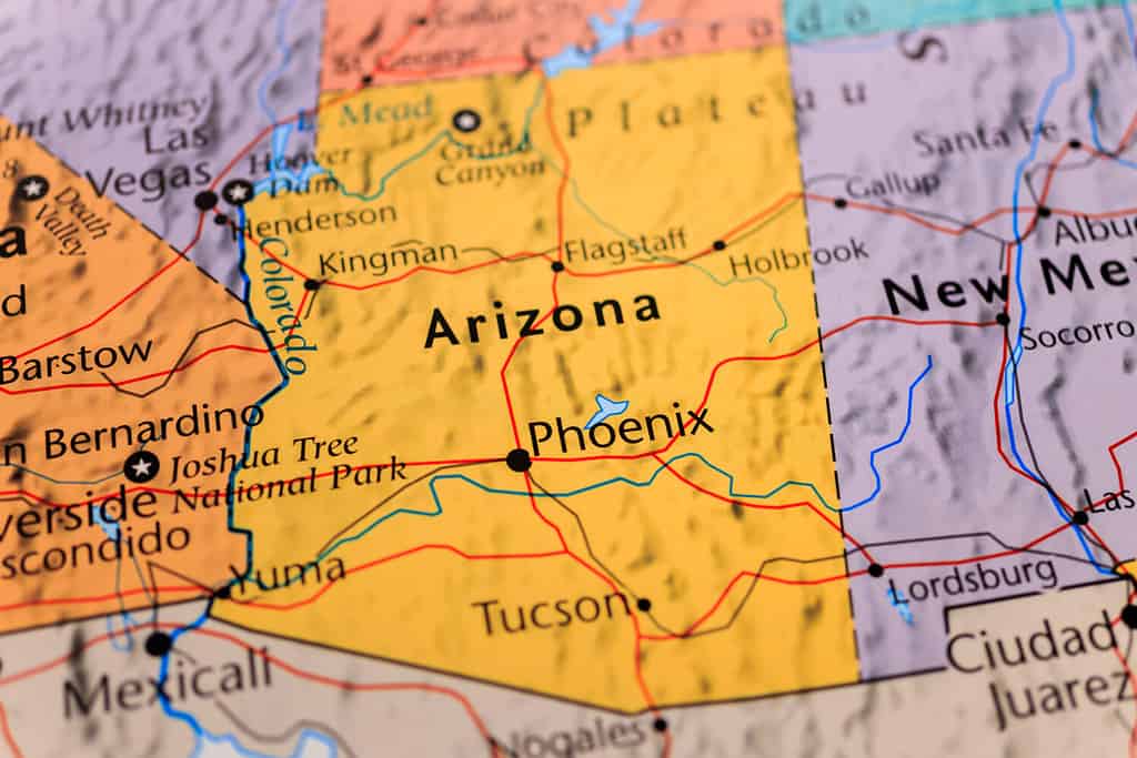
The State of Arizona is more than desert country.
©Alexander Lukatskiy/Shutterstock.com
Geologists describe the Grand Canyon State in terms of two areas, with a transition zone between them. The Colorado Plateau is a region spanning parts of parts of Arizona, Colorado, New Mexico, and Utah. It covers most of northern Arizona, and is characterized by plateaus, canyons, mountains, and other geographic features. This region includes some of the state’s most famous natural landmarks, such as the Grand Canyon, the Painted Desert, and Petrified Forest National Park. The climate of the Plateau varies widely, with lower elevations experiencing temps that range from the low 20s to the mid-90s (degrees F). Conversely, the higher elevations rarely get above 70 F in summer, and can drop into single digits in wintertime. The Plateau region also includes Arizona’s San Francisco Volcanic Field, located near Flagstaff. While the area’s had no eruptions for nearly 1,000 years, it’s likely that eruptions will occur again. Fortunately, the volcanoes’ small size and remoteness mean the unpredictable eruption won’t be very hazardous.
The southern half of Arizona is occupied by the Basin and Range Province, a geographic region that covers much of the western United States. It’s characterized by alternating mountain ranges and valleys. This area of the state supplies most of the copper mined in Arizona (which is also known as the Copper State) as well as other minerals, including silver and gold. Between this region and the Colorado Plateau lies a transition zone that has characteristics of both.
Arizona’s Lowest Point
If you want to visit the lowest point in Arizona, you’ll find yourself in the Basin and Range region. And you should get yourself a boat, or at least wear a swimsuit. According to the U.S. Geological Survey, the lowest elevation in Arizona is 70 feet above sea level, located in the Colorado River, near the city of San Luis, Yuma County, in the southwestern corner of the state. While visiting you might check out the local attractions, and cross into Sonora, Mexico for some sightseeing. Or visit the nearby city of Yuma, which boasts river recreation options like boating, jet-skiing, kayaking, and tubing.
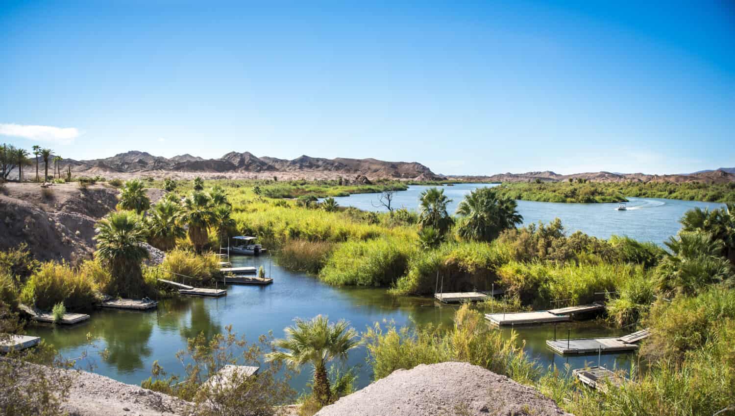
Lake Martinez is located near Yuma, Arizona. Image: KDzPloch, Shutterstock
©KDzPloch/Shutterstock.com
The Colorado River
The iconic Colorado River stretches for 1,450 miles, passing through seven U.S. states and 11 national parks and monuments. It begins in Rocky Mountain National Park, Colorado, and ends near the Gulf of California in Mexico. About 277 miles of its length pass through the Grand Canyon, the channel that the river began carving 6 million years ago. These days, the river is in danger of running dry, thanks to overuse, mismanagement, and climate change.
Why Isn’t the Grand Canyon the Lowest Point in Arizona?
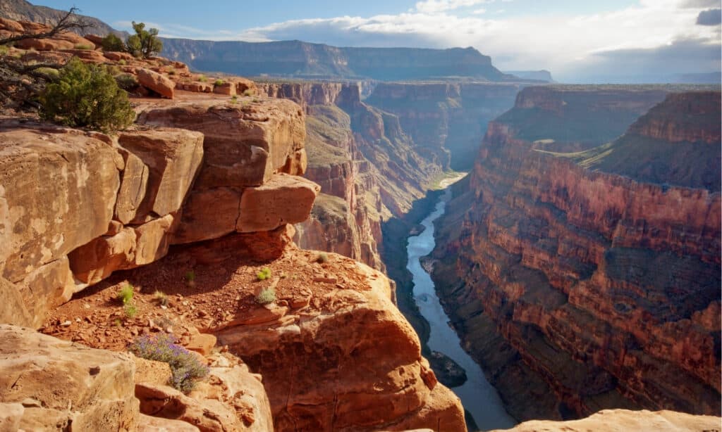
It’s a long way down…but the lowest point in Arizona is even lower than this.
©sumikophoto/Shutterstock.com
Speaking of the Grand Canyon, you may be wondering why Arizona’s lowest point isn’t located there. That’s a reasonable question. After all, some parts of the Canyon are about 6,000 feet deep, more than a mile below the rim. In fact, the exposed walls of the Canyon reveal rocks that are more than 2.5 billion years old. So how is it that the lowest elevation in Arizona doesn’t lie within this immense and ancient chasm?
The answer is that the GC is located on the Colorado Plateau. Long before the Colorado River began its epic erosion, between 70 and 30 million years ago, plate tectonics caused an uplift of the whole region. The resulting elevated area raised the uppermost layer of what would become the Grand Canyon from the bottom of the ocean to as high as 9,000 feet above sea level. From that height, the Canyon’s depths are still much higher than areas of Arizona’s Basin and Ridge region. And it’s in this part of the state, where the Colorado River winds between Arizona and California, that the lowest elevation is located.
Where Is Arizona’s Highest Point?
Now that you understand a bit of Arizona geology, you might not be surprised to hear that the state’s highest point is found on the Colorado Plateau. Humphreys Peak is the state’s highest mountain, reaching 12,633 feet. That’s high enough for ice and snow to be present in the summertime. Located north of Flagstaff, Humphreys Peak is a volcanic mountain that’s part of the above-mentioned San Francisco Volcanic Field. It’s possible to hike to the top, but it’s not an easy trek. Flagstaff itself sits at 7,000 feet above sea level, and the hiking trail begins at 9,300 feet. That means oxygen levels drop low enough to make breathing noticeable more difficult.
Humphrey’s Peak in Flagstaff is Arizona’s highest point.
©Jim David/Shutterstock.com
The photo featured at the top of this post is © ExpertOutfit/Shutterstock.com


How to Add Us to Google News


Thank you for reading! Have some feedback for us? Contact the AZ Animals editorial team.