
New Zealand is a large island country that consists of two main islands and approximately 600 smaller ones. Much of New Zealand’s landscape was formed by volcanism, and there are numerous extinct and dormant volcanoes across the country. However, there are also several that are still active, including one that was the site of one of the largest eruptions in the entire world — so large that it turned the sky over Rome red.
So, keep reading to learn about the active volcanoes in New Zealand, including where they’re located and when they last erupted!
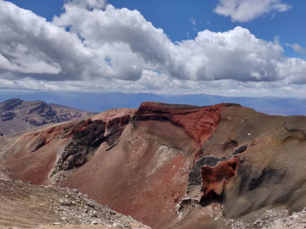
1. Mount Tarawera
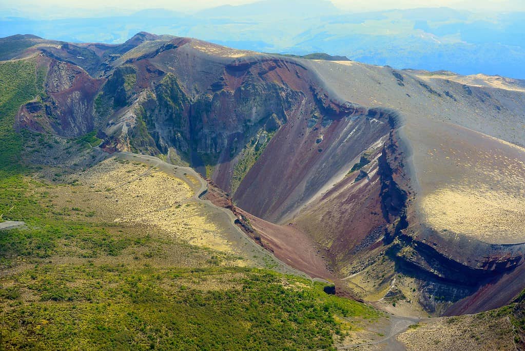
The large fissure on Mount Tarawera was caused by the deadly 1886 eruption.
©giiku, CC BY-SA 2.0, via Wikimedia Commons – Original / License
The first volcano on the list is Mount Tarawere on New Zealand’s North Island, where it is situated within the Taupō Volcanic Zone. Mount Tarawera features a series of lava domes that have a large fissure down the center due to a previous eruption that occurred in 1886, killing 153 people.
There are several lakes surrounding the volcano that were formed by the eruption and they are popular tourist attractions. There are also a number of hiking trails and guided tours across the volcano itself.
Mount Tarawere is still considered to be an active volcano, and a local legend suggests that the appearance of a “phantom waka” (canoe) will signal the next eruption. Prior to the 1886 eruption, several tourists reported seeing a waka approaching them, only for it to disappear into the mist.
2. Mount Ngauruhoe
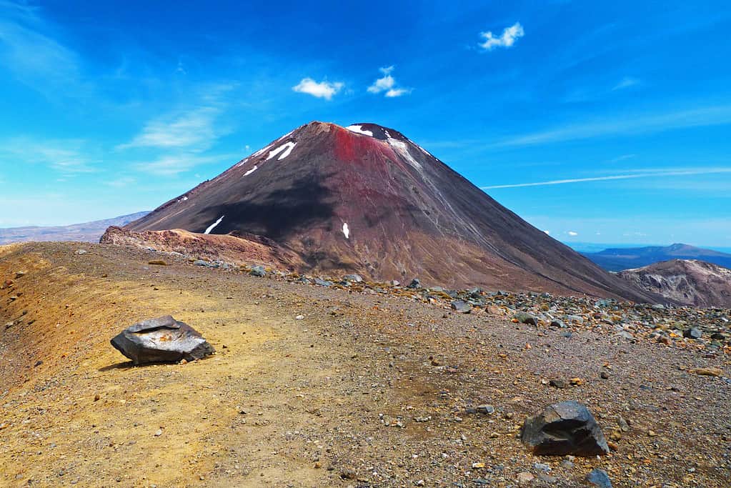
Mount Ngauruhoe featured in the Lord of the Rings film.
©Milan Sommer/iStock via Getty Images
The next volcano is Mount Ngauruhoe, which is also located on the North Island. Mount Ngauruhoe is 7,516 feet high and is the youngest volcano in the Mount Tongariro volcano complex. It is a stratovolcano and last erupted in 1977.
Although Mount Ngauruhoe is considered to be one of the most active volcanoes in New Zealand, scientists now believe that the lack of recent earthquakes in the area may mean that the chances of another eruption in the near future are unlikely.
The volcano and the surrounding area are popular spots with tourists and hikers due to their stunning appearance. Mount Ngauruhoe also featured as Mount Doom in Lord of the Rings, which adds to its popularity.
3. Mount Ruapehu
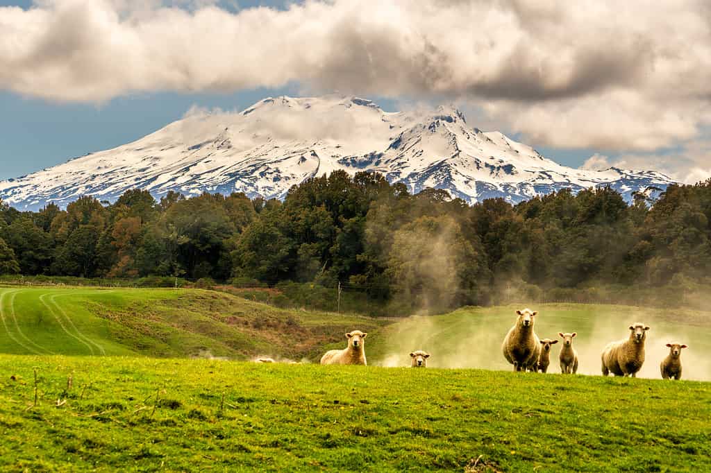
Mount Ruapehu has several ski fields on its slopes which have a warning system to alert them of an eruption.
©Stewart Watson/iStock via Getty Images
Also within the Taupō Volcanic Zone is Mount Ruapehu, which is a 9,177-foot high stratovolcano. Mount Ruapehu features three vents and is the biggest of New Zealand’s active volcanoes. Mount Ruapehu regularly experiences volcanic activity, with lahars being triggered in 2007.
The current pattern of behavior indicates that it has a larger eruption every 30 years or so, with smaller eruptions in the interim period. Mount Ruapehu features two ski areas on its slopes which are accessed by ski lifts and offer routes for both beginners and advanced skiers.
Several of the main lahar routes run through the ski areas, and there is an eruption detection system in place on the mountain. This uses seismic sensors to detect the impending eruption and triggers a warning alert at the ski areas so that skiers can get off the mountain.
4. Curtis Island
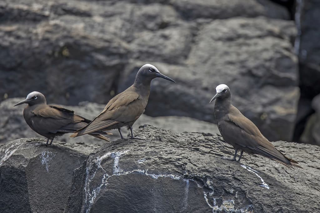
Curtis Island is the only breeding site of the brown noddy in New Zealand.
©Charles J. Sharp, CC BY-SA 4.0, via Wikimedia Commons – Original / License
The next volcano in New Zealand is an entire volcanic island — Curtis Island. The island is an active crater but is a fumarole. Fumaroles release gas and steam but do not typically release lava. The crater is 400 to 450 feet deep and features numerous hot springs and mud pools, some of which have temperatures that exceed 212 degrees Fahrenheit.
Curtis Island is unpopulated, although various species of birds nest on it. One such bird is the brown noddy, and Curtis Island is their only breeding site in New Zealand.
5. Mount Tongariro
Mount Tongariro’s last eruption occurred in 2012 when it released an ash cloud.
©Ogidya, CC BY-SA 4.0, via Wikimedia Commons – Original / License
Another volcano on the North Island is Mount Tongariro, which is located within the Tongariro National Park. Mount Tongariro is 6,490 feet high and last erupted in 2012 when it released large ash clouds in August and November. Mount Tongariro features several cones and vents, and it was in the Te Māri Craters that the latest eruptions occurred.
There are plenty of things to see and do on and around the volcano, including the Tongariro Alpine Crossing, which is a popular hike that crosses the slopes of Mount Tongariro. The route typically begins at Mangatepopo and ends near the Ketetahi Hot Springs.
6. Whakaari / White Island
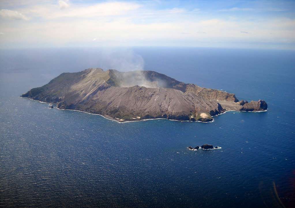
Whakaari / White Island is one of the most active volcanoes in New Zealand.
©gérard from Nouméa, (Nouvelle-Calédonie), CC BY-SA 2.0, via Wikimedia Commons – Original / License
Although Whakaari often goes by its Māori name, it is also known as White Island. The island is 1.2 miles wide and almost two miles long. It is New Zealand’s best-known volcanic island and is located just 30 miles from the North Island.
Whakaari is just a small area of a submarine volcano, and it is one of the most active volcanoes in New Zealand. It releases gas almost continually, but a powerful eruption in 2019 killed 22 people who were on the island at the time and injured many more. The island has been closed to tourists since the tragic incident, but it is still possible to take a helicopter tour over it.
7. Taupō
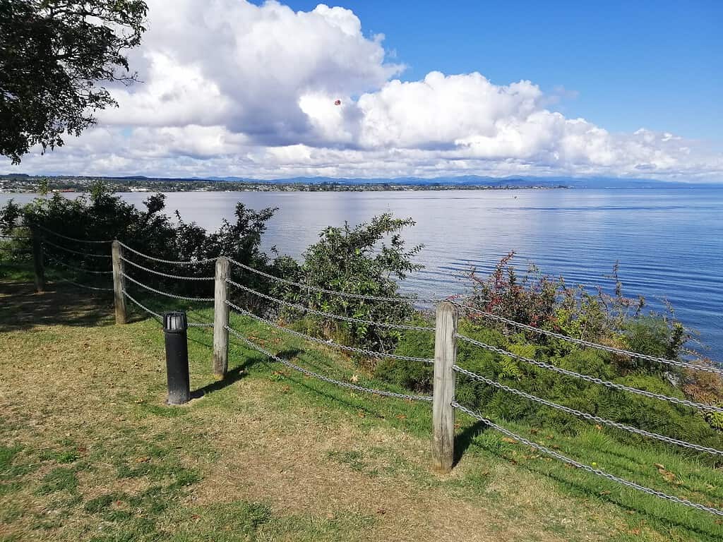
Lake Taupō is situated in the huge caldera of Taupō volcano.
©Panamitsu, CC BY-SA 4.0, via Wikimedia Commons – Original / License
The site of New Zealand’s largest-ever volcanic eruption is Taupō volcano, which is located on the North Island. Taupō first erupted approximately 300,000 years ago and has gone through many periods of significant volcanic activity.
One of Taupō’s largest eruptions was the Oruanui eruption. This occurred 26,500 years ago and formed a massive caldera which is now the site of Lake Taupō. The lake spans 238 square miles, making it the largest lake in New Zealand. Although Taupō’s last significant eruption occurred 1,800 years ago, there has still been seismic activity detected as recently as this year, meaning it is still an active site.
8. Raoul Island
Raoul Island is part of the Kermadec Islands Marine Reserve.
©Lawrie Mead at en.wikipedia, Public domain, via Wikimedia Commons – Original / License
The unique anvil-shaped Raoul Island is another of New Zealand’s volcanic islands and is located around 620 miles from the mainland. Despite the distance and its active status, visitors are allowed so long as they have the required permits.
Raoul Island features two calderas, which were formed by previous eruptions, as well as several small lakes. The area also forms part of the Kermadec Islands Marine Reserve. Raoul Island last erupted in 2006 when ash was released. However, there have also been numerous strong earthquakes in the area since, some of which have caused tsunamis.
9. Mount Taranaki
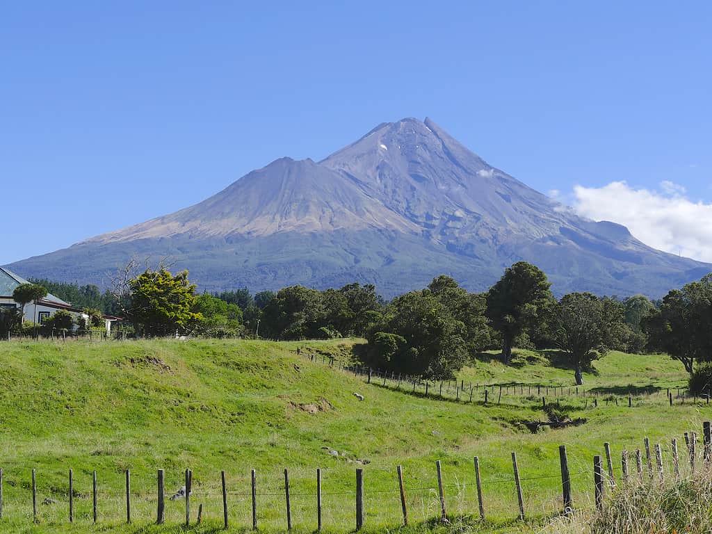
Mount Taranaki is located within the Egmont National Park.
©Ulrich Lange, Bochum, Germany, CC BY-SA 4.0, via Wikimedia Commons – Original / License
The final volcano on the list is Mount Taranaki, which was also named Mount Egmont by Captain James Cook in 1770. The volcano has an elevation of 8,261 feet and is located on the North Island. Mount Taranaki last erupted around 1854. However, it is still considered to be active, with a significant chance of an eruption occurring. This is because it historically erupted approximately every 90 years, often with very few warning signs.
Mount Taranaki forms part of the Egmont National Park, which was formed in 1900. In total, the park covers an area just short of 132 square miles. There are plenty of activities on and around the volcano, with several hiking trails across its slopes, as well as a ski field on the eastern side.
The photo featured at the top of this post is © Dave Young, CC BY 2.0, via Wikimedia Commons – License / Original


How to Add Us to Google News


Thank you for reading! Have some feedback for us? Contact the AZ Animals editorial team.