
Iceland, a land of ice and fire, is a remarkable island in the North Atlantic Ocean. It is home to breathtaking landscapes, volcanoes, geothermal activity, and unique biodiversity. The formation of this extraordinary island is a fascinating tale of geological forces at work over millions of years. In this article, we will delve into the captivating story of how and when Iceland was formed, exploring its volcanic origins, glacial sculpting, and ongoing transformation.
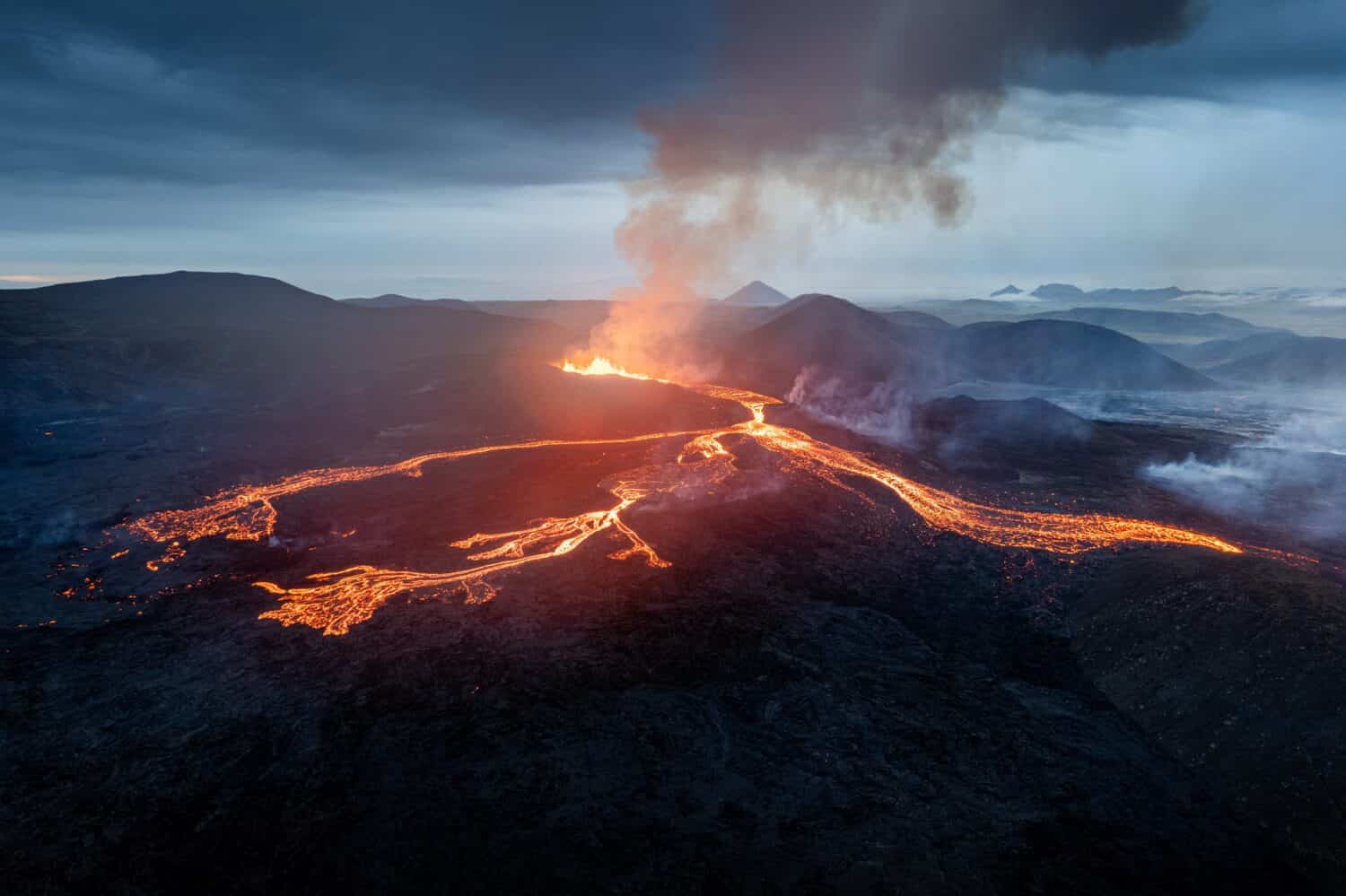
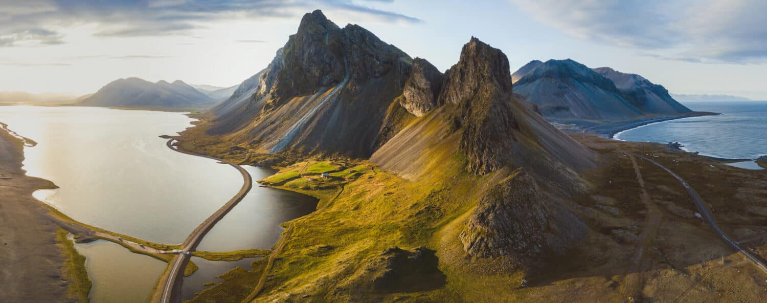
Iceland formed roughly 20 million years ago.
©Wirestock Creators/Shutterstock.com
An Overview of How and When Iceland Was Formed
Many geologists share that Iceland owes its existence to the Mid-Atlantic Ridge, a vast underwater mountain range formed by tectonic activity. This ridge marks the boundary between the Eurasian and North American tectonic plates. As these plates move apart, magma from the Earth’s mantle rises to fill the resulting gap, creating a new crust. This process began roughly 60 million years ago, when North America and Eurasia separated, and seafloor spreading began in the Northeast Atlantic.
Iceland was formed roughly 20 million years ago when the nascent Icelandic hotspot began to form. A hotspot is an area of intense volcanic activity resulting from a plume of molten rock ascending from deep within the Earth’s mantle. As the Eurasian and North American plates continued to diverge, the hotspot remained stationary, resulting in a chain of volcanic islands over time.
Volcanic Activity
The initial stages of Iceland’s formation involved the eruption of basaltic lava flows. The repeated volcanic activity gradually built up a broad landmass. These basaltic lava flows are the result of relatively calm eruptions, resulting from shield volcanos, with lava pouring out from fissures or volcanic vents.
Over time, multiple eruptions occurred, each layer of lava adding to the shield’s height and breadth. The lava solidified, forming a crust, and the subsequent eruptions added more layers, gradually building the island’s foundation.
Glacial Sculpting
The second key player in Iceland’s formation is its extensive ice cap. Glaciers cover about 11% of the island’s total area as of the present day. Glaciers have also played a vital role in shaping Iceland’s unique topography, sculpting majestic fjords, valleys, and dramatic mountain ranges.
During the last Ice Age, which peaked around 20,000 years ago, enormous ice sheets covered much of Europe and North America, including Iceland. As the ice sheets moved, they carved deep valleys and created U-shaped valleys through a process called glacial erosion.
As the climate warmed and the ice began to retreat, glacial meltwater formed rivers that shaped the landscape further. These rivers transported vast quantities of sediment, which filled in the valleys, creating rich, flat plains known as outwash plains.
Continued Transformation
Iceland’s formation is an ongoing process, with new geological events continuing to shape the island today. The tectonic activity that created Iceland persists. The North American and Eurasian plates are pulling apart at a rate of about 2.5 centimeters per year. This constant separation results in regular volcanic activity and earthquakes.
Iceland is home to numerous active volcanoes, some of which have gained global attention with their eruptions, such as Eyjafjallajökull in 2010 and Fagradalsfjall in 2021. These eruptions are reminders of the dynamic forces that have been at work for millions of years and continue to shape the landscape of Iceland.
Overall, the formation of Iceland is a remarkable story of geological processes, combining volcanic activity and glacial sculpting. Over millions of years, the island emerged from the ocean’s depths through the continuous eruption of basaltic lava flows. Glacial forces then shaped the land, creating the iconic fjords and valleys we see today. Iceland’s ongoing tectonic activity ensures that the island remains a hotbed of volcanic and geothermal wonders, making it an awe-inspiring place to explore and appreciate the forces shaping our planet.

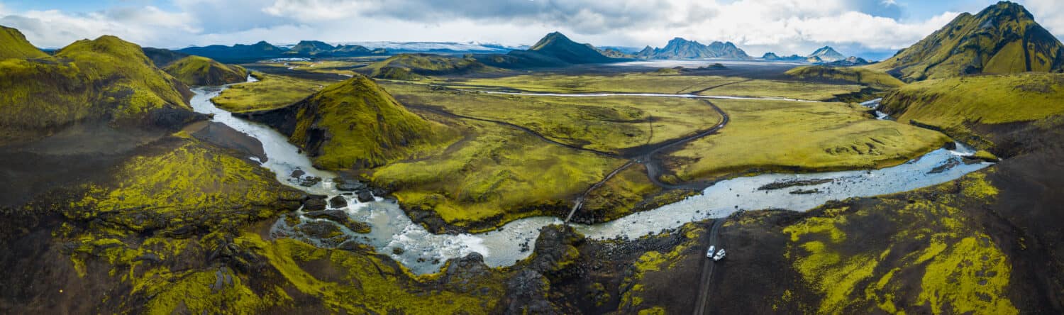
Glaciers played a significant role in the development of Iceland.
©MT-R/Shutterstock.com
The Timeline of How and When Iceland Was Formed
The formation of Iceland is a captivating geological journey that spans millions of years, encompassing distinct periods and stages. Now that we have a general outline of how Iceland was formed let’s take a close look at the general timeline of its formation.
The Formation of the Iceland Hotspot (roughly 16 to 20 million years ago)
The inception of Iceland goes back approximately 16-20 million years ago. The island’s formation is due to the Mid-Atlantic Ridge, where the Eurasian and North American tectonic plates meet. A stationary hotspot formed beneath the Earth’s surface as these two plates moved apart. This hotspot generated intense volcanic activity, which gave rise to a chain of volcanic islands. And thus, this created the birthplace of the Iceland Plateau and the island of Iceland.
Ongoing Volcanic Activity (roughly 15 million years ago to 2 million years ago)
During this period, the volcanic eruptions in Iceland were primarily characterized by basaltic lava flows. Basaltic lava, rich in iron and magnesium, is fluid and low in viscosity. This allows it to flow easily across the surface, forming expansive lava fields. Over time, repeated eruptions led to the gradual construction of the landmass known as Iceland.
The Last Ice Age and Glacial Sculpting (roughly 2.6 million years ago to 11,000 years ago)
Starting around 2.6 million years ago, the Earth stepped into a period known as the Pleistocene Epoch or the last Ice Age. Extensive ice sheets covered much of Europe and North America, including Iceland. Volcaniacvitiy continued, but glaciers played a transformative role during this time, shaping Iceland’s landscape through glacial erosion. The movement of the ice sheets carved deep U-shaped valleys, fjords, and rugged mountain ranges. Glacial meltwater also contributed to the formation of outwash plains by depositing sediment in the valleys.
Post-Glacial Rebound and Modern Landscape (11,000 years ago – Present)
As the climate warmed and the ice sheets began to retreat approximately 11,000 years ago, a process known as post-glacial rebound commenced. With the removal of the immense weight of the glaciers, the landmass rebounded gradually. This ongoing rebound continues to reshape Iceland’s landscape today.
Ongoing Tectonic Activity and Volcanic Events (Present)
The tectonic forces responsible for Iceland’s formation continue to be active today. The North American and Eurasian plates are still moving apart, creating the ideal conditions for volcanic activity. Iceland is home to numerous active volcanoes, and eruptions occur periodically. These volcanic events contribute to the ongoing transformation of the island’s geology, adding new layers of volcanic material and reshaping the land.
Iceland formed from intense volcanic activity resulting from the separation of the Eurasian plate and the North American plate.
©David Varga/Shutterstock.com
The Geography of Iceland Today
The landscape of Iceland is a breathtaking symphony of natural wonders shaped by its unique geology and dynamic forces of nature.
Glaciers and Ice Caps
Iceland has spectacular glaciers and ice caps. It has approximately 269 named glaciers, which cover around 11% of the country’s total area. Of these glaciers, 13 cover about 4 square miles or more a piece, with the largest, Vatnajökull, covering an incredible 3,200 square miles. Vatnajökull is the second-largest ice cap in Europe. It dominates the southeastern part of the island. Other prominent glaciers include Langjökull, Hofsjökull, and Myrdalsjökull. These icy giants shape the landscape with their immense size, creating a dramatic contrast against the surrounding volcanic formations.
Volcanoes and Volcanic Formations
Iceland is a land of fiery geologic activity, dotted with approximately 130 active and dormant volcanoes. There are roughly 30 active volcanos. Among the notable ones is Eyjafjallajökull, known for its 2010 eruption that caused widespread disruption. Of the three major volcanos types, Iceland is home to all three. They include cinder cone volcanoes, composite volcanoes, and shield volcanoes. The most common are composite volcanoes, also known as stratovolcanoes. Volcanism in Iceland has included rift valleys, geysers, hot springs, rhyolite mountains, basalt column formations, lava fields, and craters. These formations showcase the power and beauty of volcanic activity that has shaped the island’s unique topography over time.
Fjords, Cliffs, and Beaches
Iceland’s coastline is a treasure trove of natural wonders. Fjords, such as Eyjafjörður, were carved by glacial and volcanic activity and adorn the country’s shoreline. They offer spectacular vistas with steep mountainsides, cascading waterfalls, and serene waters. Cliffs, such as those found at Látrabjarg and Dyrhólaey, provide nesting grounds for seabirds and offer panoramic views of the surrounding sea. Black sand beaches, like Reynisfjara and Diamond Beach, captivate those who visit Iceland with their striking contrast against the wild ocean waves.
Valleys, Basalt Formations, and Geysers
Iceland’s valleys, sculpted by glacial and volcanic processes, add depth and serenity to the landscape. Þjórsárdalur and Jökuldalur are just a few examples of the picturesque valleys that dot the country. Basalt, the volcanic rock formed from solidified lava, is a prominent feature in Iceland’s landscape. Basalt columns, such as those at Reynisfjara and Svartifoss, create stunning natural formations that add an otherworldly charm to the scenery. Iceland also has many geysers dotting the country, such as the famous Strokkur, which erupts every 5 to 10 minutes.
The Island of Surtsey
Smaller islands surround Iceland, and each offers its unique landscapes. The volcanic island of Surtsey, located off the southern coast, is of particular significance. This island formed through a series of volcanic eruptions between 1963 and 1967. It is one of the youngest islands in the world. Surtsey is a UNESCO World Heritage Site and provides valuable insights into the process of island formation and colonization by plant and animal species.
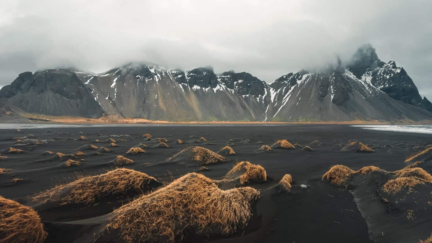
Iceland has many black sand beaches as a result of millions of years of volcanic activity.
©kasakphoto/Shutterstock.com
How Iceland Utilized Geothermal Power
Iceland holds an abundance of geothermal energy resources. Their geothermal power utilization is a shining example of sustainable and renewable energy practices. Through innovative technologies and harnessing its unique geothermal resources, Iceland has established itself as a global leader in geothermal energy production. The country’s geothermal power plants provide electricity, district heating, and support agricultural activities, all while reducing greenhouse gas emissions and promoting environmental sustainability. Iceland’s success in utilizing geothermal energy serves as an inspiration for other nations seeking to diversify their energy sources and embark on a path toward a greener future.
What is Geothermal Energy?
Geothermal energy is the utilization of heat stored within the Earth’s crust. In Iceland, this valuable resource stems from its location on the Mid-Atlantic Ridge and the presence of hot volcanic activity. The country’s geothermal reservoirs are formed by the interaction of magma and groundwater, creating vast heat reserves beneath the surface.
Geothermal Power Generation
Iceland utilizes geothermal power to generate electricity and provide heating for residential, industrial, and agricultural purposes. Geothermal power plants harness the heat from underground reservoirs and convert it into electricity through a process known as binary cycle or flash steam technology.
Binary cycle technology utilizes a secondary fluid with a lower boiling point than water. As the hot geothermal fluid passes through a heat exchanger, it heats the secondary fluid, causing it to vaporize and turn a turbine connected to a generator, producing electricity.
On the other hand, Flash steam technology involves directly extracting hot water or steam from geothermal reservoirs. The high-pressure geothermal fluid is released into a lower-pressure system, causing it to turn into steam. The steam is then used to drive a turbine, producing electricity.
The Role of Geothermal Power in Iceland
Geothermal power plays a vital role in Iceland’s energy landscape, providing a reliable and sustainable source of electricity and heating. The country’s commitment to harnessing geothermal energy stems from its desire to reduce dependence on fossil fuels, minimize greenhouse gas emissions, and promote environmental sustainability.
1. Electricity Generation
Geothermal power plants contribute significantly to Iceland’s electricity generation. They produce a substantial portion of the country’s total electricity consumption, reducing reliance on imported fossil fuels. The consistent and renewable nature of geothermal energy ensures a stable power supply, making it an essential component of Iceland’s energy infrastructure.
2. District Heating
Iceland uses Geothermal energy extensively for district heating. The hot water and steam from geothermal reservoirs are piped directly to homes and buildings for space heating and hot water supply. Geothermal district heating has a profound impact on reducing greenhouse gas emissions and promoting energy efficiency, making it an environmentally friendly solution for Iceland’s heating needs.
3. Greenhouses and Agriculture
The abundant geothermal heat in Iceland has facilitated the growth of greenhouse cultivation. Geothermal energy powers the heating systems in greenhouses, creating a controlled and favorable environment for year-round crop production. This enables the cultivation of a wide range of fruits, vegetables, and flowers, contributing to Iceland’s agricultural self-sufficiency and reducing the need for imports.
Sustainability and Environmental Benefits
The utilization of geothermal power in Iceland brings significant sustainability and environmental benefits. By relying on a renewable energy source, the country minimizes its carbon footprint and reduces reliance on fossil fuels. Geothermal energy production produces less greenhouse gas emissions than traditional energy sources, supporting Iceland’s commitment to combating climate change and transitioning to a greener future.
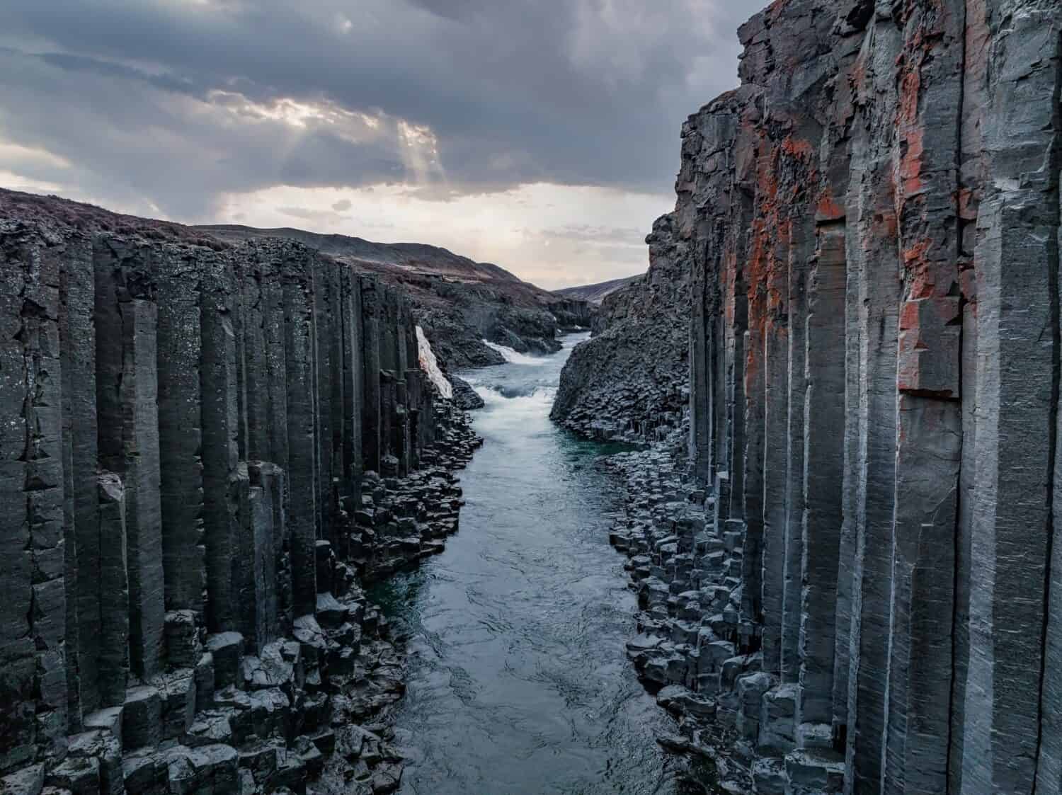
Basalt column formations are a result of volcanic activity.
©RAW-films/Shutterstock.com
Conclusion
Iceland emerged over millions of years. It is a geologically young island that is roughly 20 million years old. How and when Iceland was formed can be explained through the dynamic interplay of geological forces. Situated on the Mid-Atlantic Ridge, Iceland owes its existence to the relentless movement of tectonic plates. As the Eurasian and North American plates diverged, a stationary hotspot generated intense volcanic activity, giving rise to a chain of volcanic islands that have developed into what we know as Iceland today.
The formation of Iceland unfolded in distinct stages, beginning with the eruption of basaltic lava flows. Over time, these repeated eruptions built up a broad landmass known as the Icelandic Plateau. Volcanic Glacial activity during the last Ice Age aided in the sculpting of Iceland’s rugged topography, shaping deep valleys and creating remarkable fjords.
Today, Iceland continues to be a testament to the ongoing forces of nature. The tectonic activity between the plates persists, resulting in regular volcanic eruptions and earthquakes. The island boasts active volcanoes, geothermal wonders, majestic glaciers, and dramatic coastlines, all shaped by the intricate dance of geological processes.
The Icelandic landscape is incredibly diverse thanks to its diverse geological features.
©Song_about_summer/Shutterstock.com


How to Add Us to Google News


Thank you for reading! Have some feedback for us? Contact the AZ Animals editorial team.