
The American Southwest offers some of the most amazing hiking routes in the country and even the world. From the Superstition Mountain range to the Grand Canyon and other, smaller ranges, the views are incredible, wildlife spotting and birding opportunities are abundant, and the terrains range from challenging to easy.
Be sure to prepare properly for all hiking with proper footwear, sunscreen, hats or visors, and proper clothing. Pack plenty of water (extra is recommended!) and snacks and GPS enabled smartphones, flashlights, and a compass or compass app to ensure your safety while out there.
Animals You Might See on Your Arizona Hikes
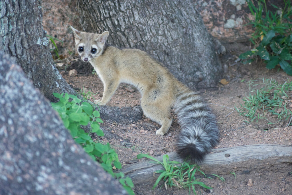
The Ringtail Cat is the official state animal of Arizona and related to the raccoon.
©Carlos R Cedillo/Shutterstock.com
Arizona wildlife comes in abundance in practically every area of the state. Some of the most fascinating creatures you might spot while out on the trail include:
- Mule deer
- Ringtail cats (state animal)
- Skunks
- American beaver
- Shrews
- North American porcupines
- Gophers
- Kangaroo rats
- White-nosed coatis
- Chipmunks
- Prairie dogs
- American badgers
- Otters
- Weasels
- Ferrets
- White tail deer
- Bighorn sheep
- Sonoran pronghorns
- American bison
- Elks
- Coyotes
- Black bears
- Ocelots
- Hummingbirds
- Woodpeckers
- Black ibis
- Grebes
- Cactus wren (state bird)
Flatiron Summit, Superstition Mountains
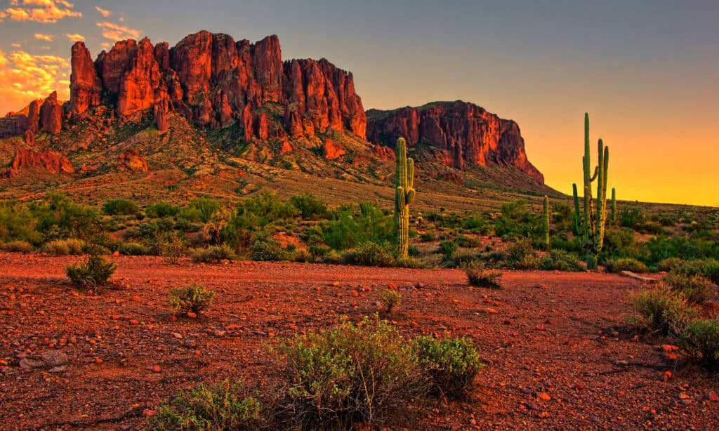
Hiking Flatiron Summit offers a big reward: a 360-degree view over the Superstition Mountains, Valley of the Sun, and Phoenix.
©iStock.com/jenifoto
- Distance: 6.2 miles
- Challenge Level: Challenging
- Elevation Gain: 3,415 feet
- Type: Out and back
A favorite challenging hike in Arizona, the Flatiron Summit offers a 6.2-mile round-trip hike with plenty of elevation to keep the hike exciting. The elevation gain reaches approximately 3000 feet and takes most average fitness hikers several hours.
Not far from Phoenix, the Flatiron Summit should be started early in the morning to beat the heat and help you time your return to shade and rest early enough to recover for the evening festivities. The challenging hike is recommended only for experienced hikers as it will probably put anyone else of commission for a while with that intense elevation gain and distance.
The views for the hike encourage many folks to try it anyway, so if you do decide to go for it, be sure to prepare properly and clear the evening’s schedule of anything strenuous. 360-degree views over the Superstition Mountains, the Valley of the Sun, and Phoenix are a prize, for sure.
Follow the blue dots on the trail and pay close attention to where they diverge. Many a hiker has missed the dots and had to backtrack a good long way to return to the proper trail. And don’t be fooled by the beginning of the trail – it starts out flat but quickly becomes anything but.
A nominal fee at the entry point for Flatiron Summit Trail will be needed.
Weaver’s Needle, Superstition Mountains
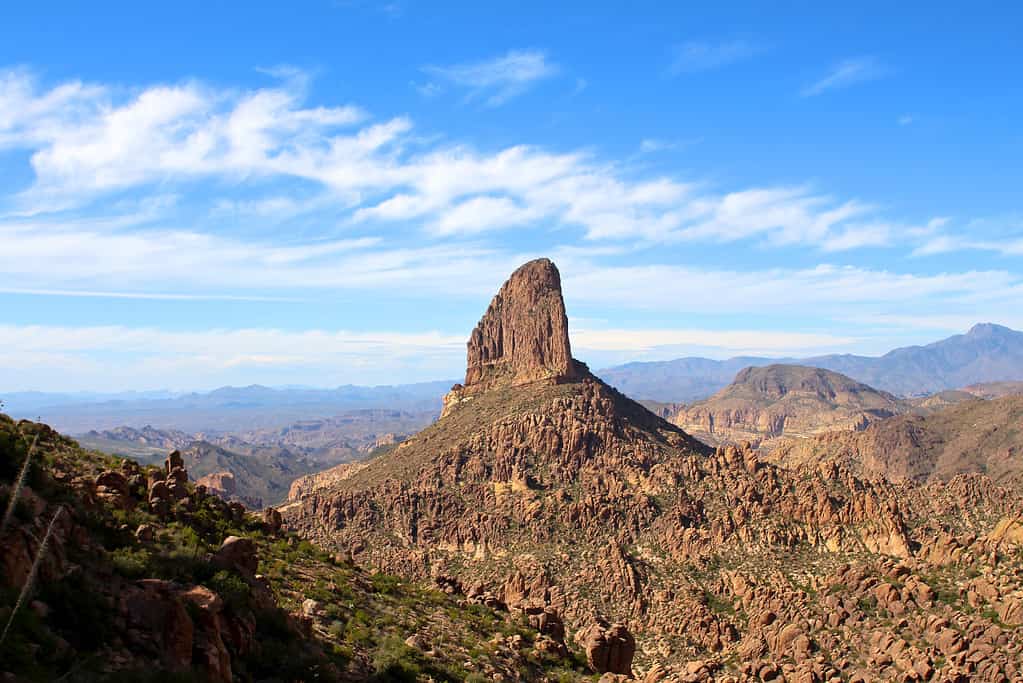
Weaver’s Needle is seen from the Peralta Trail in the Superstition Wilderness Area of the Tonto National Forest in Arizona.
©iStock.com/Monica Lara
- Distance: 8.02 miles
- Challenge Level: Challenging
- Elevation Gain: 2,153 feet
- Type: Out and back
Another challenging hike that locals and visitors alike aspire to, Weaver’s Needle offers plenty of wow-factor for those able to brave it. The summit, itself, is one of the most unique and absolutely breathtaking stone formations in the region, appearing to rise seamlessly from the desert floor.
Weaver’s Needle is part of the Superstition Mountains, soaring to 4,553 feet. The climb may be done nontechnically but it’s a tough hike for anyone – even experienced hikers. In fact, it’s recommended as technical climb and should not be attempted by beginners or even intermediates.
Of the two routes that can be taken to the top, the eastern is considered less difficult but significantly longer, which puts many folks off, especially with the off-trail portions. The western approach is more challenging but shorter – and should only be completed by technical means with at least one well-experienced climber.
Cholla Trail, Camelback Mountain
Cholla Trail takes hikers up Camelback Mountain.
©iStock.com/Jeremy Janus
- Distance: 3 miles
- Challenge Level: Moderate
- Elevation Gain: 1,153 feet
- Type: Out and back
Depending on who you ask, the Cholla Trail is either easy and quick (folks who hike a lot) or moderately challenging. It’s only a 3-mile trail, but it’s got an elevation gain of 1,158 feet. Cholla Trail takes hikers up Camelback Mountain, offering incredible views of Scottsdale and Phoenix. You’ll do some rock scrambling along the way, particularly towards the top, so be prepared.
Situated in Paradise Valley, Arizona, the trail generally demands moderate to strong fitness. Ideally, take to the trail between October and May, hit the trail early in the morning to avoid the heat, and leave the pups back at the hotel (they’re not allowed on the trail).
Echo Canyon Loop, Chiricahua National Monument
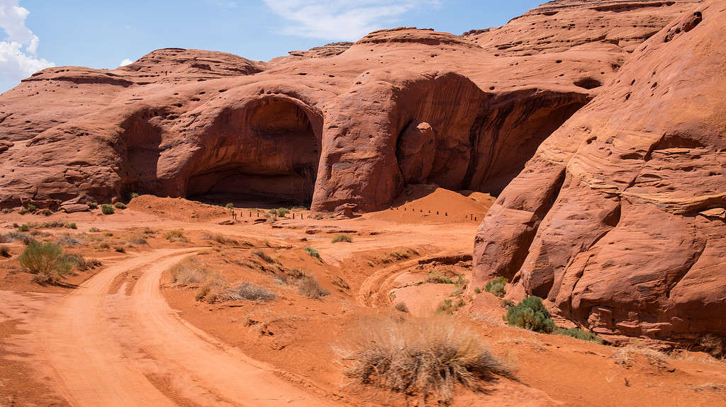
A popular Arizona hike is to Big Hogan Arch in Monument Valley.
©iStock.com/CircleEyes
- Distance: 4 miles
- Challenge Level: Moderate
- Elevation Gain: 593 feet
- Type: Loop
Considered by many as the best hike in all of Arizona, the Echo Canyon Loop is idyllic for moderate-level hikers looking for brief gains and plenty of views. The Chiricahua National Monument provides stunning rock formations with rhyolite pinnacles you’ll marvel at as you hike your way along the 4-mile trek.
Along the trail, you’ll find some shady spots for resting, in the shade of cypress and pines. The Monument is said to look like the “Cochise Head” of the Apache chief. Bring a picnic with you and enjoy a leisurely day along the less-crowded trail for 3 to 4 hours, with just a 593-foot elevation gain. The best times to visit are spring and autumn.
Do note that the trail runs through some narrow passages between spires and slots in the rocks known as “wall street” because of the closed-in walls.
For longer hikes around, the Big Loop links to several others, including Echo Trail, forming a 7-mile hike total.
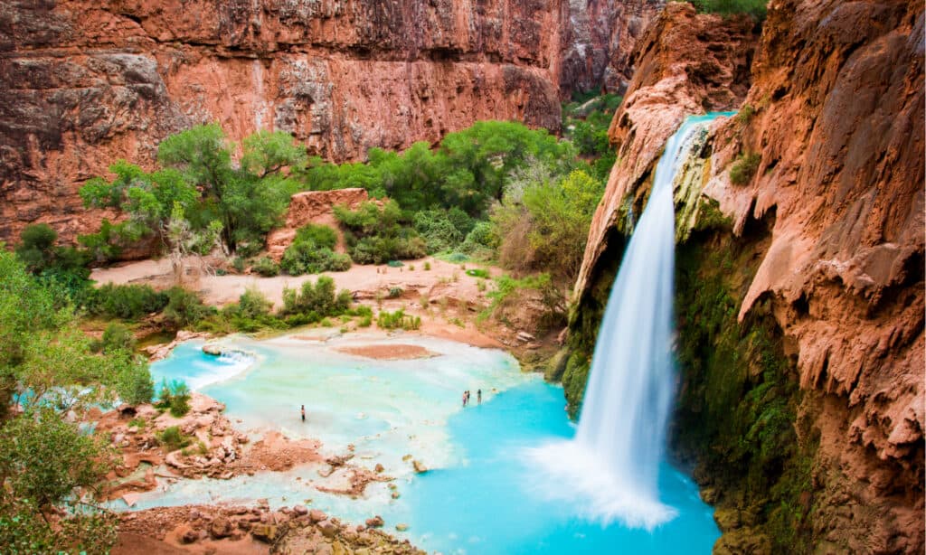
Beaver Falls, Grand Canyon – Havasupai Indian Reservation
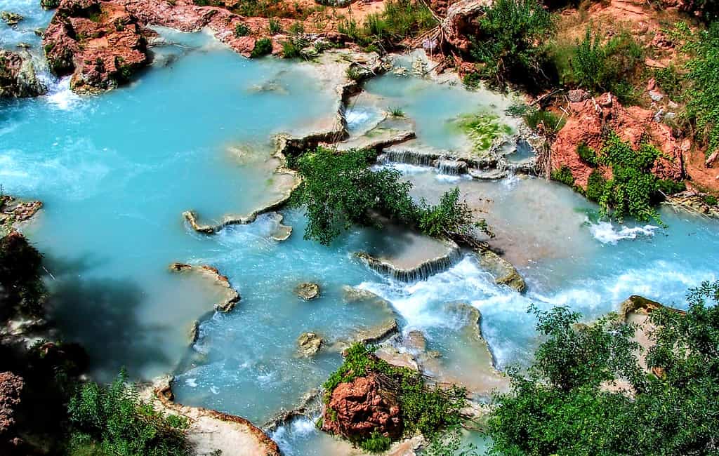
Beaver Creek Falls Arizona is on the Havasupai reservation. Permits are required to visit the falls.
©iStock.com/Jeremy Christensen
- Distance: 6 miles
- Challenge Level: Moderate
- Elevation Gain: 1,200 feet
- Type: Out and back
Eager to experience the unique and beautiful Beaver Falls? The hiking trail is, admittedly, a bit harder to get to than some – but hikers find the journey completely worth it.
Heading out from the base of Mooney Falls, you’ll make your way to the most challenging Havasupai waterfall to reach, with a full day’s hike ahead of 6 to 7 hours.
The hike to Beaver Falls is approximately 6 miles, with a 1,200-foot elevation gain, making it a moderate to challenging hike. Along the way, you’ll pass beside the sparkling, turquoise waters of Havasu Creek where cascading pools invite swimmers to cool off on the hike.
For the hike, you will need a special permit because of the waterfall’s location within the Havasupai Indian Reservation. Make a reservation in advance to guarantee you’re able to hike in.
And, to make it successfully, it’s best to download an app like AllTrails to keep on track and know exactly where you’re going and how you’ll get there.
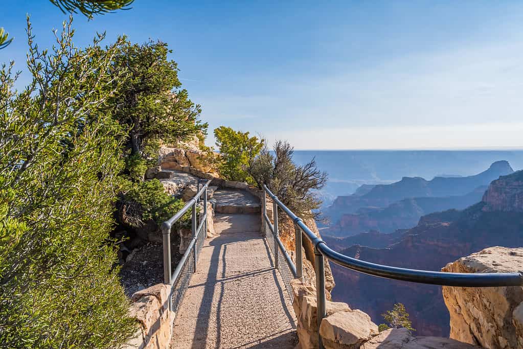
The Bright Angel Trail, Grand Canyon
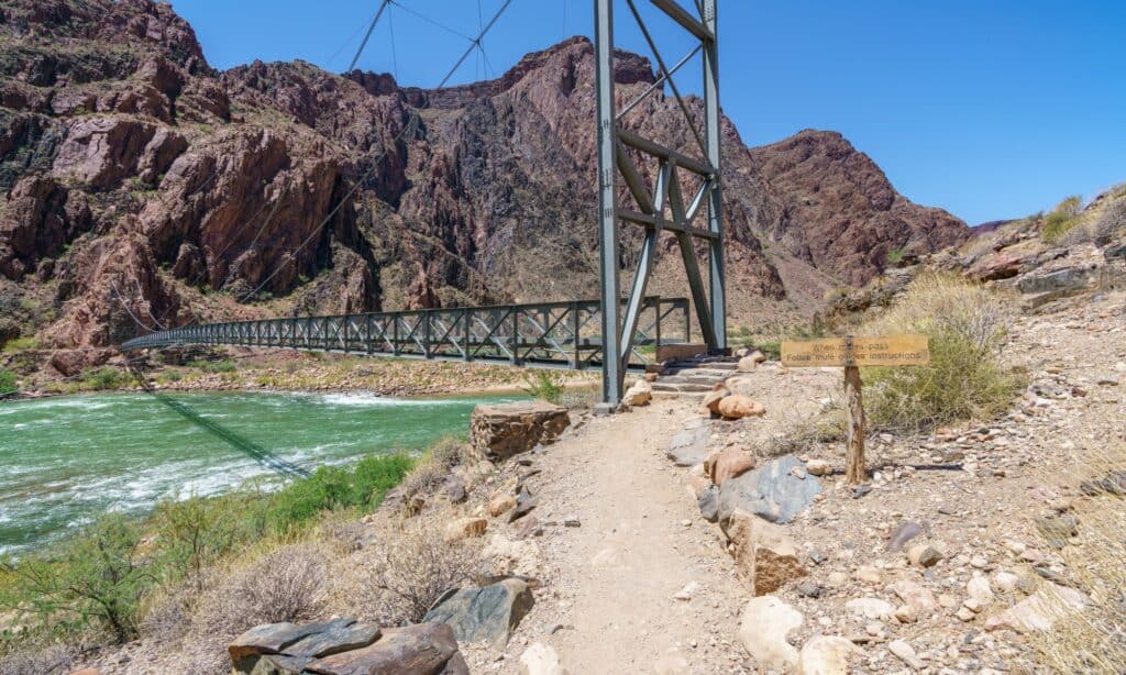
This walking bridge is along the Bright Angel trail in the Grand Canyon.
©cb_travel/Shutterstock.com
- Distance: 12 miles
- Challenge Level: Challenging
- Elevation Gain: 3,000 feet
- Type: Down and back
Perhaps the most famous hiking trail in Arizona is the Bright Angel Trail situated in the Grand Canyon. The trek consists of 12 miles of tough terrain in dry season and often impossible to pass terrain in the colder months. New hikers should not attempt the full Bright Angel Trail.
Starting at the top of the canyon, you’ll hike your way down in, with the return trip going up, and thus far more challenging than the way going. As you go, you’ll also have to watch out for the mule trains, as this is the trail they use to carry folks down in who aren’t as conditioned for hiking.
Bright Angel Trail begins at the edge of the South Rim of the Grand Canyon and leads down into the canyon and directly to the Colorado River. Because of the intensity and length of the hike, it’s best to plan on at least two days for the trail, ideally more if you’d like to take your time.
You can also choose to only hike part of the way (many folks do this, even inexperienced hikers who are moderately fit), going as far as a half mile or the full 12-mile length.
Huge drop-offs on the outer edge of the trail may be intimidating for some in any season, but in colder seasons, the ice and snow can make the trail incredibly treacherous.
Some wishing to hike the Grand Canyon may be better off choosing other, easier trails (see below for these suggestions).
South Rim Trail, Grand Canyon
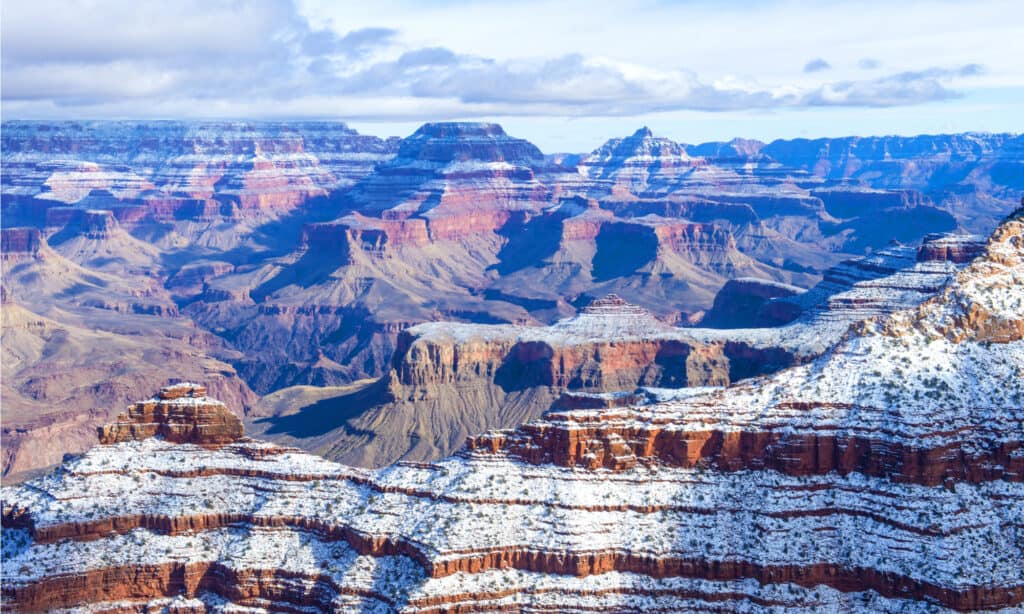
Grand Canyon in winter can be seen from South Rim.
©Kobby Dagan/Shutterstock.com
- Distance: Any up to 13 miles
- Challenge Level: Easy
- Elevation Gain: minimal
- Type: Multi-entry point
For those looking for an easy hike at the Grand Canyon, the South Rim Trail is your winner. The trail goes for 13 miles along the edge of the South Rim, but has plenty of parking, pickup and drop-off locations, and almost no elevation changes. The paved trail is accessible for those with mobility challenges, as well, making it a great choice for inexperienced hikers, those needing a flat surface, and kids.
The shuttle stops at multiple locations along the trail, as well, making the trail easy to adapt to your exact goals in distance. The shuttle connects spots on the trail to each other with much shorter distances, so feel free to hop-on and hop-off to hit up the highlights, get some exercise, but not have to do the entire trail. You’ll also find plenty of park facilities and the Grand Canyon Visitor Center on the trail, with shuttle stops at most.
Some iconic points along the South Rim Trail include Mather Point, Powell Point, and Yavapai Point.
Havasupai Falls, Grand Canyon – Havasupai Indian Reservation
To hike to Havasupai Falls in the Grand Canyon you’ll need a permit.
©iacomino FRiMAGES/Shutterstock.com
- Distance: 10 miles one way
- Challenge Level: Moderate to challenging
- Elevation Gain: 2,500 feet
- Type: Out and back
A 10-mile, moderately challenging hike into the Grand Canyon will take you to Havasu Falls, perhaps the most famous waterfall in all of the United States. The rushing blue waters of the falls attract about 20,000 hikers annually.
One of the main challenges of this hike isn’t the hike itself — though that is challenging enough for most. Because of the location of the waterfall, special permits are required to visit. Entering a Native American Reservation for any reason requires permissions, which are granted via special permits. In this case, because the stunning falls are so popular, the permits are sometimes even tougher to come by as there’s a high demand for them.
Make a reservation for the hike early to help make sure you have it granted in time for your adventure in the Copper State. Once you head there, be sure to treat the land with complete respect, leaving nothing but footprints and taking nothing but pictures. Be respectful of the peoples of the land, as well, and those hiking around you.
The trip is about 20 miles round trip and though it’s technically deemed a moderately challenging hike, the heat, distance, and trail conditions are generally best attempted by experienced hikers only. Also note that in late summer and early autumn, the area is prone to flash flooding.
Cape Final Trail, Grand Canyon
A nature trail boardwalk in Grand Canyon National Park, Arizona is Cape Final Trail.
©iStock.com/Cheri Alguire
- Distance: 4 miles
- Challenge Level: Easy
- Elevation Gain: 495 feet
- Type: Out and back
Another easy-rated trail at the Grand Canyon is the Cape Final Trail, a 4-miler on the North Rim. The trail offers stunning views, a nearly level trail, and minimal crowds, as it is lesser known than most. Providing hikers with shade, the trail also winds its way through forest, a rare commodity at the Grand Canyon. The trail goes along the canyon rim for much of the distance, leading to the destination of Cape Final with incredible views.
From this vantage point, Vishnu Temple, the eastern edge of the canyon, and many other vistas and sights may be observed. It’s the perfect family-friendly hike for a casual day at the Canyon.
Cathedral Rock, Sedona
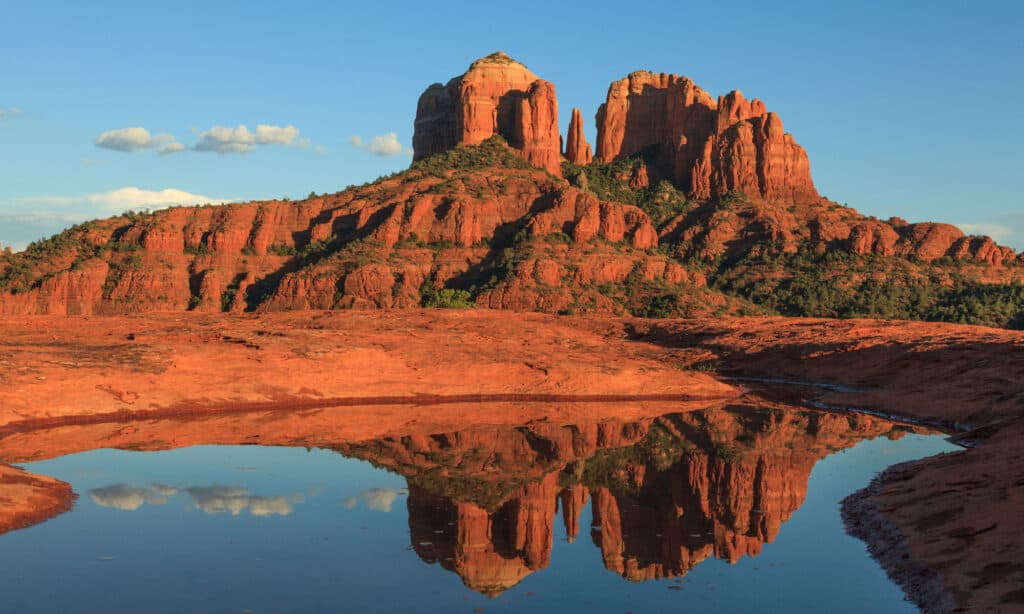
The hike to Cathedral Rock near Sedona, Arizona is challenging but short.
©iStock.com/twildlife
- Distance: 1.2 miles
- Challenge Level: Challenging
- Elevation Gain: 741 feet
- Type: Out and back
Those looking for a challenging but short hike will want to head over to Cathedral Rock near Sedona, Arizona. Each way on the trail is just 1.2 miles but the quick ascent is steep and makes the trail rather challenging. When you reach the summit, the views are absolutely amazing, with the red rocks in a unique formation.
Though the trail is challenging, if you’re not familiar with hiking, you can do the trail as long as you take it easy on yourself as you climb. Bring along plenty of water, wear a hat, and have some protein-rich snacks handy for refueling as you make your way along. You will probably find yourself scrambling over some rock, as well, going up parts of the trail. Be sure to wear footgear with excellent treads to stay safe on the hike.
Be sure to head out at the cooler times of day for the trek and have a flashlight handy if you’re heading out in the evening for that incredible sunset view.
Note that mountain bikers may be along the trail so keep an eye out. Plenty of other hikers will be out there, too, as the trail is popular among both visitors and locals. And be sure to pop over to the Chapel of the Holy Cross before or after your hike for a complete “experience” in the area.
Upper Antelope Canyon Trail, Page
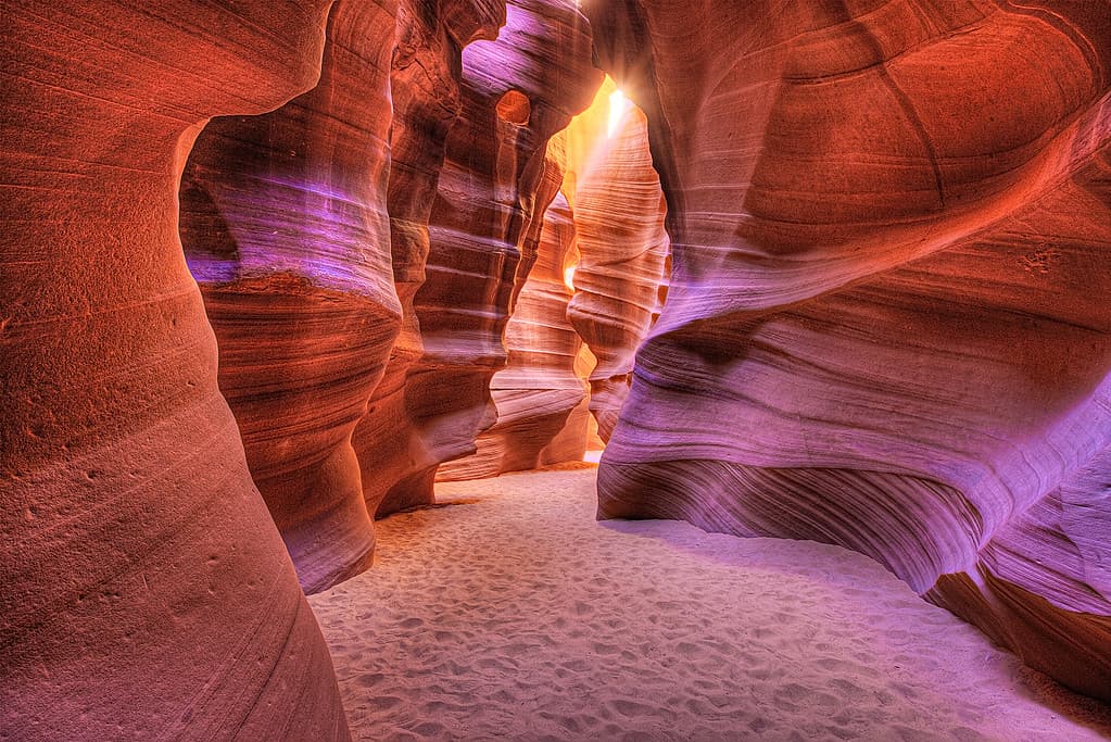
Hiking to
Antelope
Slot Canyon to see the glowing walls is an iconic quest.
©iStock.com/Left_Coast_Photographer
- Distance: 6.5 miles
- Challenge Level: Easy
- Elevation Gain: 252 feet
- Type: Out and back
For a longer, iconic, but easy hike, head to Antelope Canyon (or Corkscrew Canyon) and take the Upper Trail. This trail may be wheelchair accessible for those willing to make the effort (no service animals are permitted, though) and takes you to the beautiful arch of Antelope Canyon photo fame. Antelope Canyon is known as a slot canyon, which means that it is a long, narrow channel with sheer rock walls on both sides, made by erosion in sedimentary rock.
It should be noted that Antelope Canyon is located on Navajo land. A mandatory tour is the only way to access the canyon and trail. A lower trail exists, but this trail is more challenging and not accessible for those with mobility concerns. The lower trail has steps down into the canyon, however. So, some folks may opt for the more challenging route for this access. For those needing an accessible route, skip the canyon altogether in poor weather as the Upper Trail will become too challenging to traverse, according to most.
The photo featured at the top of this post is © iStock.com/jenifoto


How to Add Us to Google News


Thank you for reading! Have some feedback for us? Contact the AZ Animals editorial team.