
The Basics of El Niño
What is El Niño? El Niño is a climate pattern in the Pacific Ocean. During El Niño, wind shifts cause warm surface water from the equator to move eastward toward the coasts of Central and South America, as well as of the United States, causing heavy rainfall. Just because El Niño occurs in the Pacific Ocean doesn’t mean it only affects those areas. In fact, it affects weather worldwide. Worldwide weather depends significantly on the ocean‘s temperature. Wherever the sea is warm, more clouds form, making more rainfall in that part of the world. Near the equator in the Pacific Ocean, the sun makes the water especially warm near the surface, thus creating more clouds and, eventually, more rain.
El Niño Conditions vs. Normal Conditions
In normal conditions, heavy winds that blow along the equator drive warm surface water near South America westward toward Indonesia. When this occurs, the cooler water underneath ascends in the direction of South America towards the ocean’s surface. However, when there is an El Niño, in the winter and fall of some years, winds are much weaker than usual, blowing in the opposite direction towards South America instead of Indonesia. This causes the warm surface water along the equator to pile up along the coast of South America and then move northbound towards southern Chile and California, creating the El Niño effect.
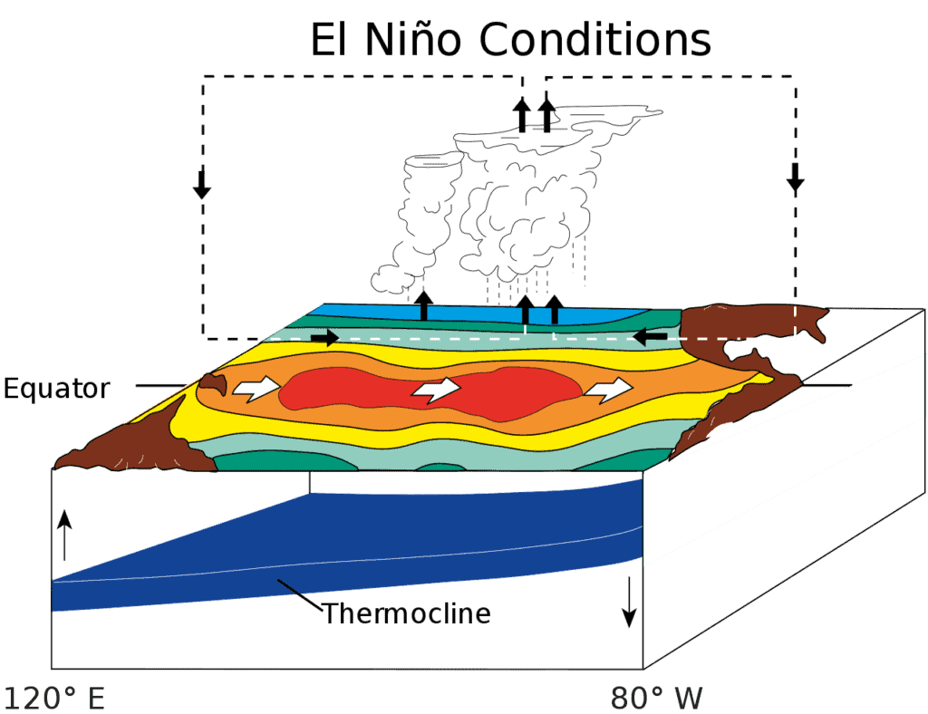
During El Niño, wind shifts cause warm surface water from the equator to move eastward toward the coasts of United States, Central, and Southern America, causing heavy rainfalls.
How El Niño Affects the World
During the years of El Niño, rain clouds conform over the warm part of the ocean. These clouds maneuver inland and depose more rain than customary in Central and South America and the United States. Although South and Central America and the United States receive much more rain, other areas suffer drought. El Niño causes unusual weather patterns all over the globe, creating lakes out of deserts and dust out of rainforests. It impacts the ocean’s temperatures worldwide, the strength and speed of ocean currents, the health and survival of coastal fisheries, and local weather from South America to Australia and beyond.
Differences between El Niño and La Niña
We can’t talk about El Niño without talking about La Niña. La Niña and El Niño are weather patterns in the Pacific Ocean that vary from normal conditions but differ in warm and cool phases. During typical weather patterns, trade winds blow warm water west from South America towards Asia. Cold water then rises closer to the top of the surface to replace warm water due to the phenomenon known as fluid dynamics. El Niño is a weather pattern characterized by the uncommon warming of waters in the eastern tropical end of the Pacific Ocean. If El Niño is a warm phase, then La Niña is the cool phase.
During El Niño, trade winds that typically push the water towards Asia are weaker, making warm water flow east towards the west coast of South and North America. During La Niña, trade winds are way more rambunctious than average, so more water gets pushed towards Asia, causing cold water instead to hit the west coast of North and South America. The patterns of moving, either warmer or colder water, have significant effects on the weather. El Niño is part of a more substantial phenomenon called the El Niño-Southern Oscillation or ENSO. La Niña (the cool phase) of ENSO is the abnormal cooling of the region’s surface waters. Both the climate patterns (El Niño and La Niña) are named for the ocean component of ENSO, while the Southern Oscillation is its atmospheric changes.
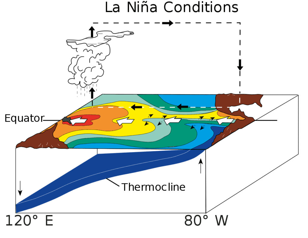
During La Niña, trade winds are way more rambunctious than average, causing cold water to hit the west coast of North, Central, and South America.
How Long do El Niño and La Niña last?
The weather patterns of El Niño and La Niña usually last between 9 to 12 months but can occasionally stick around for years. It typically shifts from La Niña to El Niño every 2 to 7 years. El Niño is a lot more common than its counterpart La Niña. The process of the shift between these two weather patterns is the El Niño Oscillation Cycle or ENSO cycle.
El Niño Frequency
While El Niño events occur every 3 years on average, intense El Niño events typically happen every 6 to 10 years. 20 El Niño events have been recorded since 1950, and about half of these occurrences were considered moderate to strong, with about six or seven considered vital. The strongest El Niño event to ever be recorded was in the winter of 1997 to 1998.
Due to the discovery of El Niño and La Niña, scientists created the term ONI to track the ocean during the El Niño oscillation weather period. During the strongest El Niño event ever recorded in the winter of 1997 to 1998, the ONI peaked at 2.3. The ONI is a 3-month difference from the average temperature in the surface waters of the east-central tropical Pacific. It has been 24 years since the strongest El Niño ever recorded.
History of El Niño
Peruvian fishermen initially recognized El Niño from the coast of South America as warmer than usual water around Christmas time. The fishermen noticed that the water would be warmer every couple of years near the start of every year. Because of the warmer water, many fish living off the coast of South America (where the ocean water is usually cooler) would leave their normal water, searching for more cold water or die. Fishermen in 1600 called this weather condition of warm coastal water and poor fishing “El Niño,” which means “the Little Boy” or “the Christ Child.” They called it this because the period of El Niño occurs at Christmastime.
Is El Niño a Fact or Theory?
El Niño is a fact. It is proven through several different theories and is as accurate as other weather phenomena like thunderstorms and hurricanes. The characteristics of El Niño are similar to previous occurrences, and its life cycle is about the same each time. Of course, each El Niño is different, just as each thunderstorm is different. Still, the basic pattern of El Niño is similar enough that meteorologists can spot an El Niño when they see it.
On the other hand, meteorologists can’t predict an El Niño like they can predict a thunderstorm. Scientists know what triggers thunderstorms and what conditions make thunderstorms more likely to occur. They know this to the point where meteorologists can predict the locations and predict severity of thunderstorms a day or two ahead. However, unlike thunderstorms, meteorologists and scientists can’t expect an oncoming El Niño. Once El Niño has started, there is no technology to predict the onset of the occurrence until it is obvious.
Can You Predict El Niño?
Scientists have various ideas and theories for why El Niños start, but they can’t predict it until it actually starts. However, El Niño allows forecasters to indicate that the incoming winter will likely be warmer than usual before it has affected the United States coast. It also predicts warmer weather than usual across northern states and wetter than average weather along the Gulf Coast. These forecasts are beneficial for farmers and water managers. However, although these forecasts are helpful to certain people, scientists remain unsatisfied because it does not answer the fundamental question of why an El Niño happens in the first place.


How to Add Us to Google News


Thank you for reading! Have some feedback for us? Contact the AZ Animals editorial team.