
The view at Forrest Gump Hill may be spectacular, But still, it’s an unlikely spot in the middle of a remote highway in rural Utah for a tourist to hop out of their car for a photo shoot. However, this particular stretch of road was made famous by the iconic movie, Forrest Gump. It’s the exact location where Forrest (played by Tom Hanks) suddenly ends his ultramarathon and announces he’s going home.
If you find yourself visiting the Four Corners area near Mexican Hat, a must-see destination is the exact spot where Forrest Gump stood in the movie.
What Was Forrest Gump’s Path in the Movie?
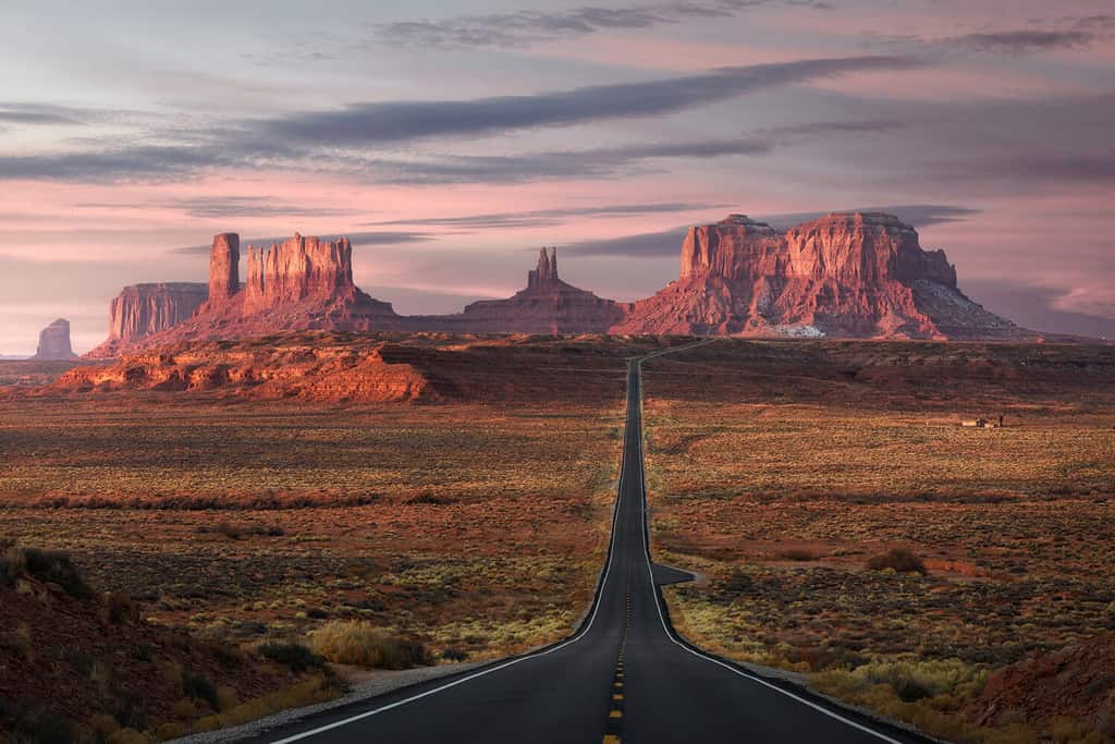
The empty road beckons at mile marker 13, along U.S. Route 163.
©Wisanu Boonrawd/Shutterstock.com
In the movie, Forrest ran for 3 years, 2 months, 14 days, and 16 hours. He began his run at his home in Greenbow, AL, and headed to the Santa Monica Pier. Not finished yet, he head back across the country, ending up at the Marshall Point Lighthouse in Maine. Finally, he runs through downtown Flagstaff, AZ, and stops at mile marker 13 on Highway 163 in Utah. Although a short scene, it’s a memorable one with the stunning buttes in the background of the arid Utah landscape.
It may sound like an impossible run in real life. However, as reported in the Guardian, Rob Pope, a veterinarian from Liverpool, followed in the fictional Forrest’s footsteps, running 15,621 miles in 422 days.
Where is Forest Gump Hill Located on a Map?
Forest Gump Hill, also called Forest Gump Point, is in the center of U.S. Route 163 at mile marker 13. Route 163 is a National Scenic Byway that runs through Monument Valley in Utah. Situated in southeast Utah near the Arizona border, the nearest airport is a three-hour drive to Pullman Airport in Flagstaff, AZ.
If you’re looking for the exact spot, you can search “Forest Gump Point” in Google Maps, and it will lead you there.
Forrest Gump Hill: Things to Know Before You Go
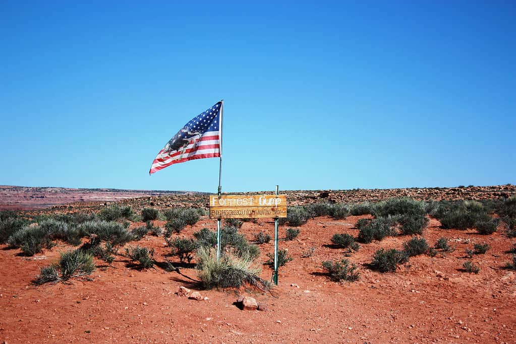
Forrest Gump Hill is marked by a wooden sign at mile marker 13 on Highway 163.
©ClaraNila/iStock via Getty Images
If you stop at mile marker 13 in the Navajo Reservation with Monument Valley in the background, you will see the same sight in the movie where Forrest famously and very suddenly stopped his run. A wooden sign marks the location, and there are pullouts on both sides of the road where tourists can park to see the view from outside their cars.
Summers Are Hot
Temperatures easily reach 100 degrees Fahrenheit or higher. For that reason, you may want to keep your adventuring along Route 163 to the spring, fall, or winter months. Summer heat is unforgiving and can cause many a vehicle to overheat.
Visiting is Free
Forrest Gump Hill is not technically inside Monument Valley, so it’s free to get out of your car and check out the location.
Watch Out for Traffic
Chances are, you won’t miss the locale even if you forget to watch the mile markers. This is because there is usually a small crowd of people posing for pictures or selfies at the famous sight. Because of this, drivers need to pay heed and watch out for bystanders in the middle of the highway. And if you get out to take a picture yourself, be sure to keep an eye out for traffic.
Best Time for Photos
The best time for pictures at Forrest Gump Hill is in the early morning. The crowds are thinner, you’ll have an easier time getting a photo without bystanders. Also, you will be facing southwest with the sun rising behind you and illuminating the buttes in the distance.
However, arriving at sunset can get an equally impressive photo with the sun setting behind the unique rock formations. Times to avoid are late afternoon or early evening when the rocks are shadowed, making them less photogenic.
About Highway 163
U.S. Route 163 runs for 64 miles between U.S. 160 and U.S. 191, linking the states of Utah and Arizona. Its endpoints are in Bluff, UT, and Kayenta, AZ. Part of the Trail of the Ancients, the route is part of a collection of National Scenic Byways in the Southwest. These highways take travelers through the vast cultural history of Native America.
Forrest Gump Point isn’t the only must-see spot along Highway 163. Other sites to visit along the route include the following.
Wolfman Petroglyph Panel Hike
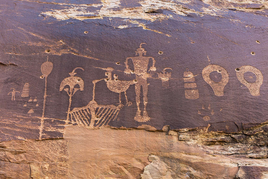
Take a stop to view an ancient petroglyph panel etched on the cliffs of Butler Wash in the Comb Ridge Area off of U.S. Route 163.
©lightphoto/iStock via Getty Images
When you are leaving the town of Bluff, where Highway 163 begins, you can stop off for a quick hike where you can view ancient images inscribed into the cliff walls. The location for the trailhead is about 5 miles west of Bluff, along Highway 163. Take Butler Wash Road 262 where a short drive will take you to the trailhead.
Valley of the Gods
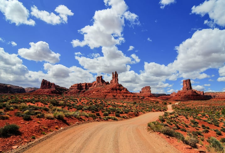
The stunning views of Valley of the Gods can be seen along a 17-mile road off U.S. Route 163.
©demerzel21/iStock via Getty Images
Valley of the Gods offers spectacular scenery similar to the Utah desert. Here you will see towering buttes amid the empty horizon. Valley of the Gods Road is a 17-mile dirt road you can access from off Route 163 just west of Bluff, Utah. It winds north and west before it connects with Highway 261. From 261, you will end up back on Highway 163 near Mexican Hat Rock.
Mexican Hat Rock
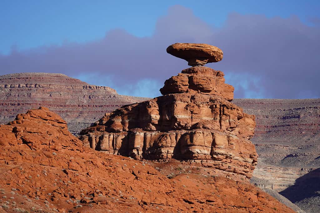
Mexican Hat Rock is a fascinating rock sculpture that is perched atop a rock formation.
©Steven Baltakatei Sandoval / CC BY-SA 4.0
This unique rock formation is shaped like an upside-down sombrero and perched precariously on top of larger rock formations. There’s a short hike if you’d like to get close to the rock, but it’s a striking sight from afar as well. The nearby tiny town of Mexican Hat is a popular starting point for rafting trips along the San Juan River. There are a few restaurants in town if you’d like to stop for a meal.
Alahambra Rock
After you pass Mexican Hat, take a look to your right. Alhambra Rock is located on Route 163 after you cross the San Juan River. There is a pullout along the highway where you can stop and pause for the view. The rock was formed over millions of years of erosion that washed away the softer rock, leaving behind Alhambra Rock.
Goosenecks State Park
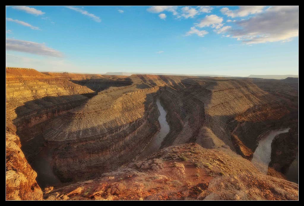
The San Juan River in Gooseneck State Park in Utah has cut stunning cliffs into the canyon walls.
©Jochen Hoog, CC BY-SA 3.0, via Wikimedia Commons – License
Take a stop at Goosenecks State Park for the stunning view of the San Juan River as it “goosenecks” through the canyon 1,000 feet below. The sharp turns of the river have carved steep canyon walls of sharp turns exposing rock that is millions of years old. The small park offers tent camping and picnic areas.
Monument Valley Navajo Tribal Park
You can see Monument Valley on Route 163, but if you’d like to stop off for a closer view, take the Monument Valley scenic drive loop. It’s a 17-mile dirt road with an entry fee. When you pay the fee, you’ll be given a map highlighting the eleven scenic stops along the road. You have the choice to take a self-guided tour or hire a guide.
For an even closer view, take a hike on the 3.2-mile lasso loop Wildcat Trail within Monument Valley. On the hike, you will see some of the most famous buttes in Utah.
Wildlife
The wildlife that makes its home in this arid, hot landscape is well adapted to the harsh conditions. Snakes have learned to thrive in dry environments. Some of the snakes living in the area include night snakes, western diamondback, gopher snakes, and prairie rattlesnakes.
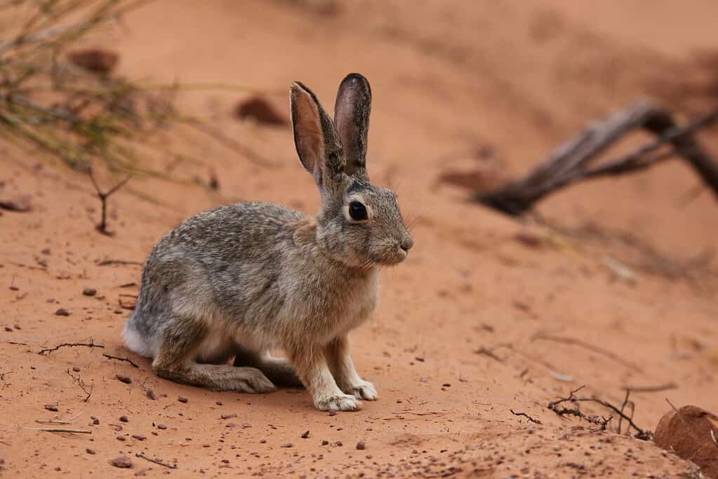
Desert cottontails have learned to live in the harsh environment of the Utah desert.
©Chris Hill/Shutterstock.com
Other small animals you may encounter include lizards, iguanas, jackrabbits, cottontails, and prairie dogs. Larger animals you may encounter include pumas (mountain lions), coyotes, and desert bighorn sheep.
Birds that have adjusted well to the desert life and can be seen around Monument Valley include red-tailed hawks, tree sparrows, mockingbirds, vireos, sage thrashers, warblers, sagebrush sparrows, and even the occasional roadrunner.
The photo featured at the top of this post is © Wisanu Boonrawd/Shutterstock.com


How to Add Us to Google News


Thank you for reading! Have some feedback for us? Contact the AZ Animals editorial team.