
As the third-largest state in the United States (trailing only Alaska and Texas), California’s borders encompass a land of extremes. The highest point in the 48 contiguous states is found in California. Mount Whitney in the Sierra Nevada Mountains of east-central California reaches 14,505 feet above sea level. And, along with the highest point in the continental U.S., California is also home to the lowest point.
California’s Lowest Point
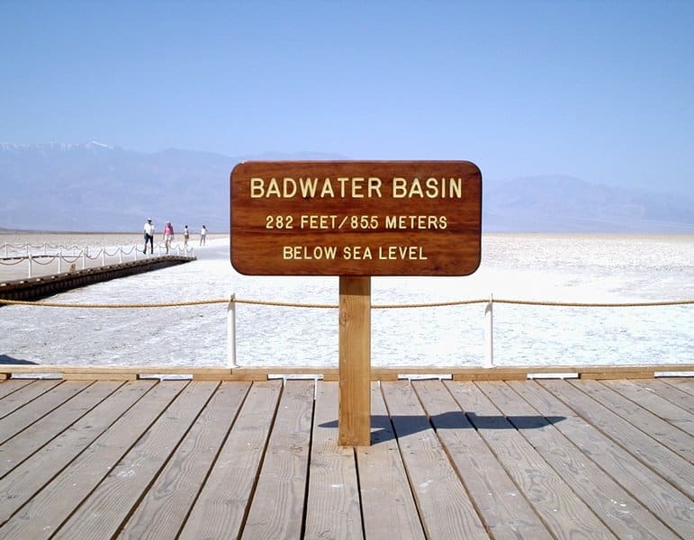
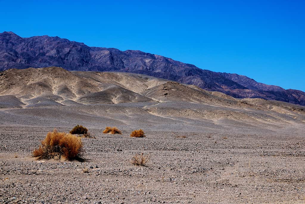
The lowest point in California is Badwater Basin in Death Valley National Park.
At 282 feet below sea level, Badwater Basin is not only the lowest point in California but also the lowest point in all of North America and the eighth-lowest point on Earth. And, in a testament to the amazing geography of California, the highest point in the contiguous U.S. (Mount Whitney) is less than 90 miles from Death Valley, home of the lowest point.
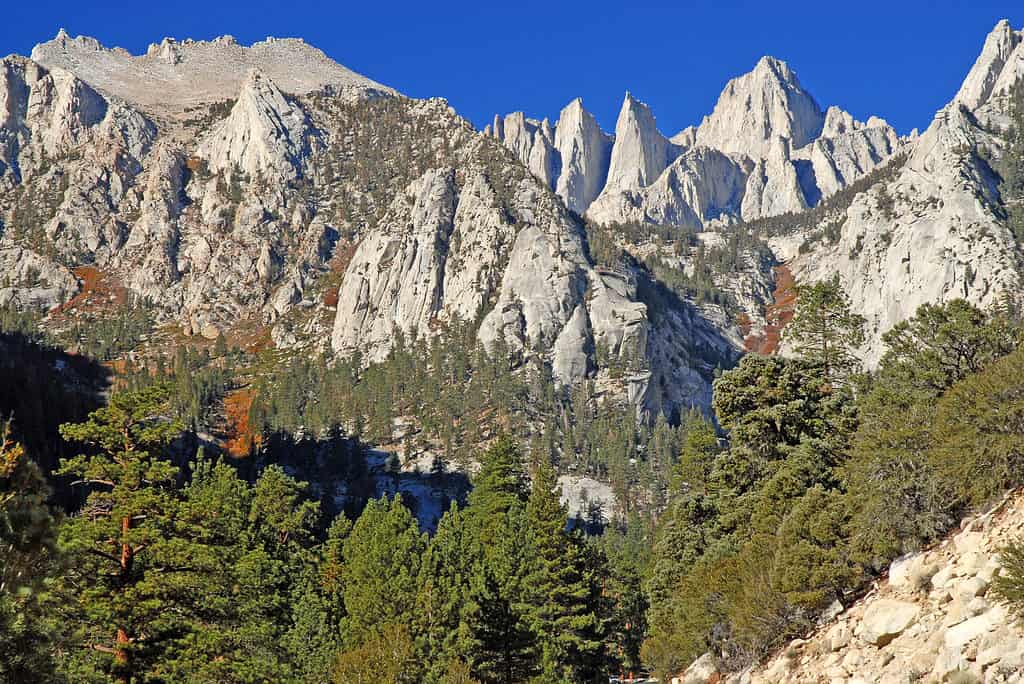
Mount Whitney, the highest point in the continental U.S., is less than 90 miles away from the lowest point, Death Valley National Park.
©nyker/Shutterstock.com
Badwater Basin
Badwater Basin was once the site of Lake Manly, an ancient lake that existed around 128,000-185,000 years ago during the Tahoe glacial stage. Because this pluvial lake had no outlet, sediment, and salt collected over time. When the lake evaporated, vast salt deposits were left behind. Today, Badwater Basin is 200 square miles of barren salt flats. The salt is comprised mainly of sodium chloride, what we know as table salt.
The white salt that covers the basin floor for miles in every direction looks like snow, but the desert temperatures will quickly remind visitors that it is definitely not snow. Badwater Basin’s average high temperature in July is 116°F. Temperatures over 120°F are common in the summer.
Badwater Basin, the lowest place in North America, features miles of white salt flats.
©Ivan / CC BY-SA 3.0 – License
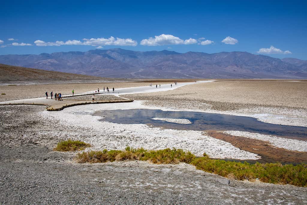
Small lakes still form in this ancient lakebed after heavy rainstorms. Badwater Basin receives less than two inches of rainfall per year. There is one day of rainfall each month, on average, in January, February, and March. The basin typically sees little to no rainfall for the remainder of the year. These are exceptionally dry conditions, even by desert standards.
However, if a downpour does develop, shallow lakes can form over the salt pan. The lakes are short-lived, though. Badwater Basin has a 150-inch annual evaporation rate, the highest in the United States. A 12-foot lake could evaporate in a single year in this desert basin.
When these temporary rain-produced lakes form, some of the salt in the basin is dissolved. After the water evaporates, it is redeposited as clean crystals. This, combined with the groundwater that rises to the surface and evaporates, creates polygon shapes on the salt flats. In this way, the shape and appearance of Badwater Basin’s salt flats are always changing.
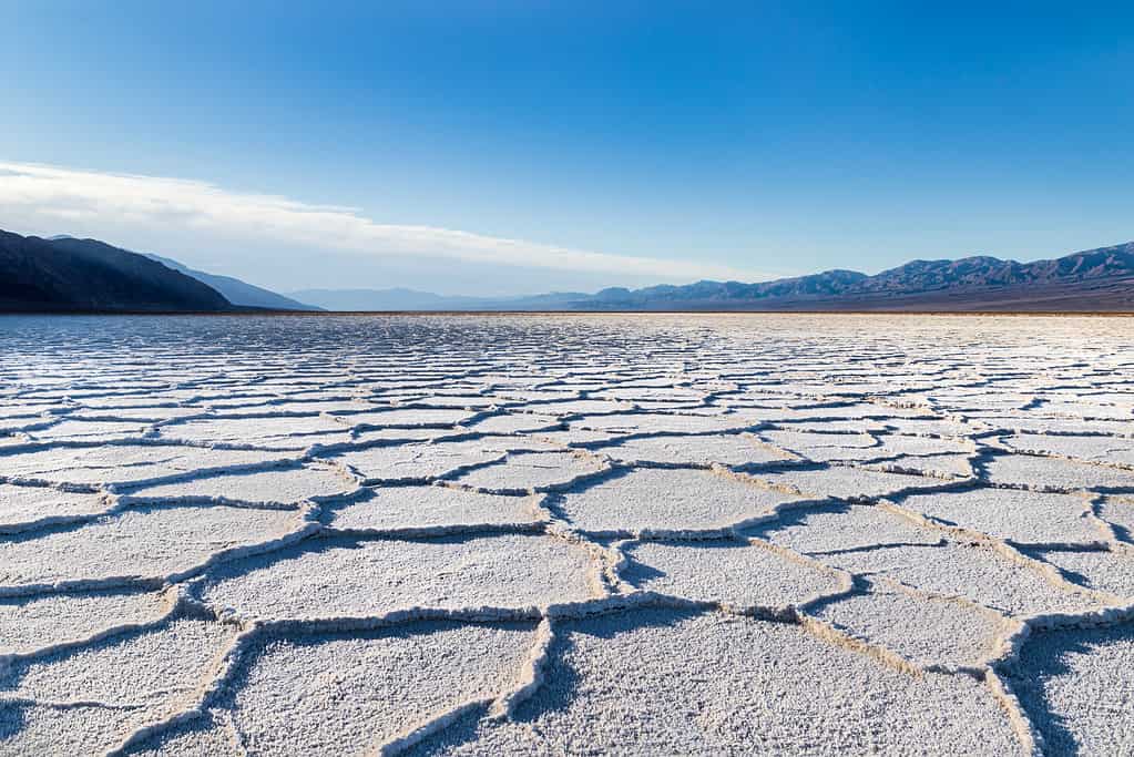
Polygons form through water evaporation on Badwater Basin’s salt flats.
©iStock.com/DGHayes
Exploring Badwater Basin
Visitors to Death Valley National Park can explore the expanse of salt flats in Badwater Basin. There is a boardwalk that is accessible off of Badwater Road. However, to really experience the basin, guests can take a hike out onto the salt flats. The out-and-back trail is approximately a one-mile roundtrip to the edge of the salt flats. Hikers can extend the hike up to two miles by traversing further onto the salt flats.
While hiking the salt flats, look for the sign marking “sea level” on the cliffs above you to demonstrate just how low the basin really is. You’ll also want to look to the west to view Telescope Peak in the Panamint Range. The peak rises to 11,049 feet above sea level, meaning the peak rises over two miles above hikers in Badwater Basin. There is no other place in the United States where such a drastic vertical relief can be seen in such a short distance.
The hike over the salt flats is easy as there is virtually no elevation change. However, the sky-high temperatures of summer can be dangerous. The National Park Service recommends hiking before 10:00 a.m. in the summer. Visitors in the winter months can enjoy a hike in much more temperate conditions. Badwater Basin’s average high temperature in January is a delightful 67°F.
The video below gives a glimpse of a Badwater Basin hike.
The Basin’s Name
Badwater Basin’s name purportedly came from a prospector’s mule who refused to drink from a spring-fed pool located near the modern boardwalk. In truth, the water in the pool is not “bad.” It is, however, very salty.
The spring-fed pool in Badwater Basin isn’t actually “bad water,” but it is very salty.
©iStock.com/Robert Michaud
While it would be reasonable to assume the salty environment in this “bad water” pool couldn’t support life, there is actually both flora and fauna in the water. Pickleweed grows here. The water is home to various aquatic insects, as well as the Badwater snail. This snail is only found naturally in this location.
Why Is Badwater Basin So Dry?
Death Valley National Park is the lowest, driest, and hottest of any U.S. national park. Those extremes all weave together to create the conditions seen in the park, including in Badwater Basin.
With less than two inches of rain per year, Death Valley National Park is the driest of all U.S. national parks.
©iStock.com/Dmitri Zelenevski
Death Valley sits east of the Sierra Nevada Mountains. Sierra Nevada is Spanish for “mountain snowfall.” These snow-covered mountains are a far cry from the dry, arid environment of Death Valley. These mountains are also the cause of that desert. Death Valley sits in the rain shadow of the Sierra Nevada.
When air moves over the windward side of a mountain range, it cools, and the volume increases. The phenomenon, known as orographic lift, causes increased precipitation.
When the air moves back down the leeward side of the mountains, it warms and dries out. This creates the rain shadow effect. It is why areas east of a mountain range are often drier than areas west of those mountains. It is often more pronounced when the topography change is extreme. The Sierra Nevada and Death Valley combine for a textbook case of an extreme rain shadow.
The moisture-rich air from the Pacific Ocean runs into the Sierra Nevada. As the air is pushed over these high peaks, it is essentially wrung out like a sponge. By the time the air crosses these mountains and drops into the low elevations of Death Valley, it is exceptionally dry. The daytime relative humidity in Death Valley is as low as ten percent in the summer. When someone pushes back against complaints about Death Valley’s weather by saying, “But it’s a dry heat!” they’re not wrong. It is exceptionally dry, and you can thank the Sierra Nevada and the Pacific Coast Range for that. Death Valley National Park, including Badwater Basin, sits in the rain shadow of these mountains. This is why Death Valley is the lowest, hottest, and driest point in the United States.
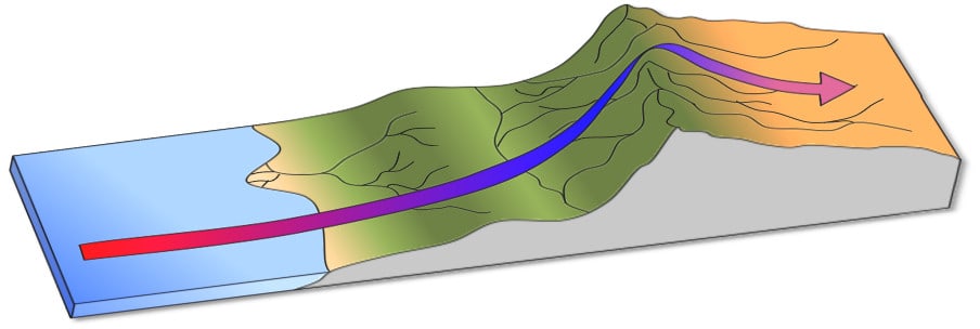
This graphic illustrates the rain shadow effect caused by orographic lift.
©Thebiologyprimer / CC0 – License
Death Valley National Park
This park packs in all the superlatives. Along with being the lowest, hottest, and driest national park, Death Valley National Park is also the largest park in the lower 48 states at over 3.4 million acres. If you want to find a larger park, you’ll have to travel to Alaska.
Much of the park abounds with life (contrary to its ominous-sounding name). Mammals such as desert bighorn sheep, coyotes, and mountain lions inhabit the park. Groups of invasive burros also roam the park, descended from burros that were used as pack animals by Mexican explorers.
The park is also home to reptiles such as the desert tortoise and the Mojave desert sidewinder as well as a host of different types of lizards.
Birds can also be seen in the park at different times of the year. The roadrunner is a year-round resident of Death Valley National Park.
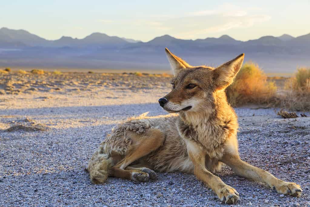
Coyotes emerge in the park at dusk.
©iStock.com/dmodlin01
The photo featured at the top of this post is © iStock.com/DGHayes


How to Add Us to Google News


Thank you for reading! Have some feedback for us? Contact the AZ Animals editorial team.