
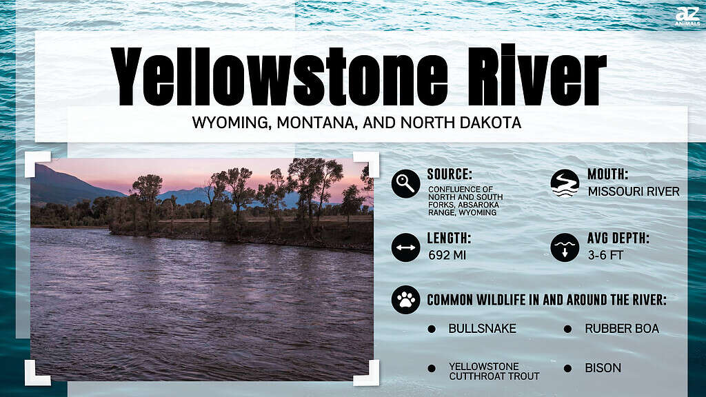
The Yellowstone River may not be the longest river in the United States, but it’s one of the most impressive.
Today, many of the longest rivers in the U.S. and worldwide no longer flow uninterrupted. Instead, their waters are controlled by dams and buffered by locks and other impediments. The Yellowstone River represents an exception to this rule. It holds the distinction of ranking as the longest undammed river in the contiguous United States. But just how long is the Yellowstone River?
In this article, we’ll explore where the Yellowstone River starts, finishes, and how long it measures. We’ll also examine the history of the river and its ecology.
How to Measure the Length of a River
Many factors go into measuring a river’s length. These include locating the river’s source and mouth and measuring its curves and bends accurately. This gets more difficult if the river flows down waterfalls, through canyons, or into and out of lakes. Tributaries only complicate things further, as do situations where a river forms from multiple sources.
For years, rivers were measured using the twine method. This involved taking a topographical map and using a length of twine to chart a river’s twists and turns. Then, you’d take the river’s measurements from the twine and expand them to scale. However, this method faces obvious limitations that can lead to over and underestimates of length.
Modern methods of measuring rivers use GIS mapping to capture, analyze, and display geographic information realistically. Even so, this method doesn’t completely solve the problem of finding a river’s source or charting its length across rugged terrain. Moreover, rivers are constantly shifting and moving; they flood, dry up, and change the landscape around them. In truth, most accepted measurements of rivers amount to no more than close approximations.
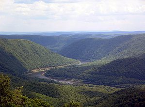
How Long is the Entire Yellowstone River?
The Yellowstone River measures approximately 692 miles.
©Cavan-Images/Shutterstock.com
According to most estimates, the Yellowstone River measures approximately 692 miles (1,114 kilometers) long. This measurement takes into account the full mainstem of the river. At its headwaters, the water exceeds 12,800 feet above sea level, while its lowest point measures 1,850 feet above sea level. At 692 miles, the Yellowstone River ranks as the 23rd longest river in the United States. However, it’s also easily the longest undammed river in the lower 48 states.
Where Does the Yellowstone River Begin?
The Yellowstone River begins in northwestern Wyoming. The source or mouth of the river lies nestled within the Rocky Mountains, namely the Absaroka Range. That said, the river does not simply spring forth from the ground. On the contrary, the Yellowstone River doesn’t officially begin until two smaller forks meet. The confluence of these forks – the North Fork and South Fork – represents the official start of the Yellowstone River. The North Fork begins along the western slopes of the tallest mountain in the Teton Wilderness, Younts Peak. Meanwhile, Thorofare Mountain is the home of the South Fork, which slowly winds its way down the mountain’s southern slope. Once the two forks meet, they then flow northward into and through Yellowstone National Park. From there, the river drains into Yellowstone Lake drops down Yellowstone Falls, and cuts through the Grand Canyon of the Yellowstone.
What are the Tributaries of the Yellowstone River?
The Yellowstone River begins where the South and North Fork meet, but the process of change does not stop there. Several tributaries flow into the river along its journey north and eastward as it seeks lower elevation. The tributaries of the Yellowstone River include the Powder River, Tongue River, Wind/Bighorn Rivers, and Clarks Fork Yellowstone River.
The first major tributary of the Yellowstone River is the Clarks Fork Yellowstone River. Named after the explorer William Clark, the Clarks Fork Yellowstone River rises in the Beartooth Mountains, part of Gallatin National Forest in Montana. From its source, the river runs 150 miles before it flows into the Yellowstone River just outside of Laurel, Montana.
Next up are the Wind and Bighorn Rivers. Despite their different names, the two rivers are actually one and the same. The Wind River refers to the upper stem of the river, while the Bighorn River refers to the lower stem. The headwaters of the Wind River rise at Wind River Lake amongst the Rockies in Wyoming. Near the northern end of the Wind River Canyon, the Wind River officially turns into the Bighorn River. The reason for the river’s dual name likely comes from the mountain barrier that separates the Wind River and Bighorn basins. The site – known as the “Wedding of the Waters” – marks where the rivers split. The Bighorn River ultimately completes the Wind/Bighorn route when it meets the Yellowstone River about 50 miles outside Hardin, Montana.
The Tongue River also rises in northwestern Wyoming amongst the Big Horn Mountains. It then runs 265 miles northeast through Wyoming and southeastern Montana until it reaches the Yellowstone River on the outskirts of Miles City, Montana.
The last majority tributary of the Yellowstone River is the Powder River. Like the Tongue River, its headwaters lie in north-central Wyoming amongst the Bighorn Mountains. It flows for 375 miles until its confluence with the Yellowstone River at Miles City, Montana.
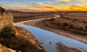
Where Does the Yellowstone River End?
The end of the Yellowstone River is in Dakota.
©iStock.com/samuel howell
The Yellowstone River’s 692-mile journey takes it from northwestern Wyoming through Montana and into North Dakota. Shortly after crossing the North Dakota border, the river flows to its confluence with the Missouri River. The mouth of the Yellowstone River intersects with the Missouri River near Buford, North Dakota.
Buford gets its name from Fort Buford, a historic United States Army Post outside town. The post stands at the confluence of the Yellowstone and Missouri Rivers, which makes it an important strategic point.
Is the Yellowstone River Longer Than the Missouri River?
The Yellowstone River currently holds the record for the longest undammed river in the contiguous United States. It flows for 692 miles, which means it also ranks as the 23rd longest river in the US. However, it pales in comparison to the Missouri River, which flows nearly 2,341 miles long. Moreover, several rivers in the region other than the Missouri also measure longer than the Yellowstone River. These include the Green River (730 miles long) and Snake River (1,078 miles long).
The Yellowstone River and the American West
The Yellowstone River served an important role for many people throughout the history of the US. Several Native American tribes had hunting grounds at different sites along its banks. The Crow, Cree, Cheyenne, and Lakota Sioux all maintained temporary settlements near the river and also used the river for transportation.
Similarly, the Yellowstone River also served as a vital transportation route for settlers in the 19th century. The River was explored by William Clark of the Lewis and Clark Expedition, which aided later settlers once gold was discovered near Virginia City, Montana, in the 1860s. Settlers commonly arrived in the region on riverboats and also ferried goods up and down the river. The US Army used the river to transport survivors from the Battle of the Little Bighorn, which witnessed the complete destruction of Colonel George Armstrong Custer and 5 of the 12 companies of the 7th Cavalry at the hands of a much larger force of Lakota warriors.
The Yellowstone River Today
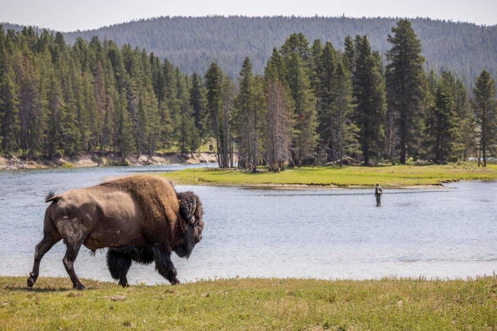
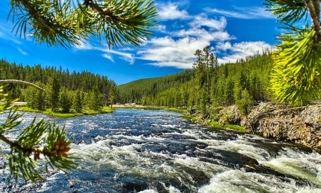
Today, the Yellowstone River is considered by many anglers to be one of the best trout fishing streams in the United States. The river drives a considerable amount of tourism in the region and is considered a blue ribbon stream due to its excellent recreational fishing. People also flock to the Yellowstone River to take in its beauty. You can find waterfalls, lakes, and scenic vistas along its route that frequently draw hikers, campers, and other nature enthusiasts to come and appreciate the river’s beauty.
The Yellowstone River’s Ecosystem
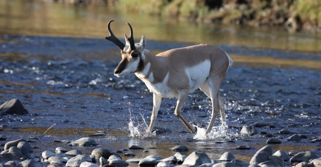
Pronghorns can be found beside the Yellowstone River.
©Frank Fichtmueller/Shutterstock.com
The Yellowstone River supports a wide range of plants and animals. It’s home to numerous species, including:
Several endemic fish species can be found in the waters of the Yellowstone River, including the Utah chub, Arctic grayling, cutthroat trout, and the endangered pallid sturgeon. Other commonly found fish include the introduced rainbow and brown trout. The river’s lack of dams makes it a prime spot for trout and other fish to live and breed.
Unfortunately, several events and factors threaten the Yellowstone River’s delicate ecosystem. Oil spills in 2011 and 2015 dumped thousands of barrels of oil into the river, polluting the water and harming the local wildlife. Farming, agriculture, and mining also contribute to contamination in the area around the river, which raises the risks of environmental pollution. Severe droughts have also affected the river in the past, which resulted in decreased streamflows and increased dissolved solid concentrations in the river’s watershed basins.
The photo featured at the top of this post is © iStock.com/T Schofield
How to Add Us to Google News


Thank you for reading! Have some feedback for us? Contact the AZ Animals editorial team.