
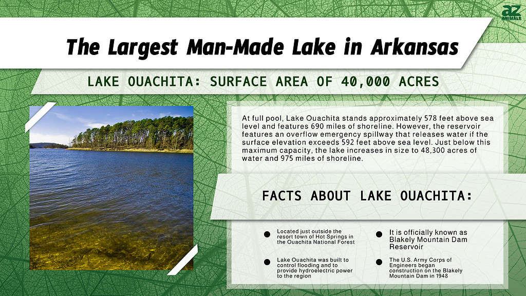
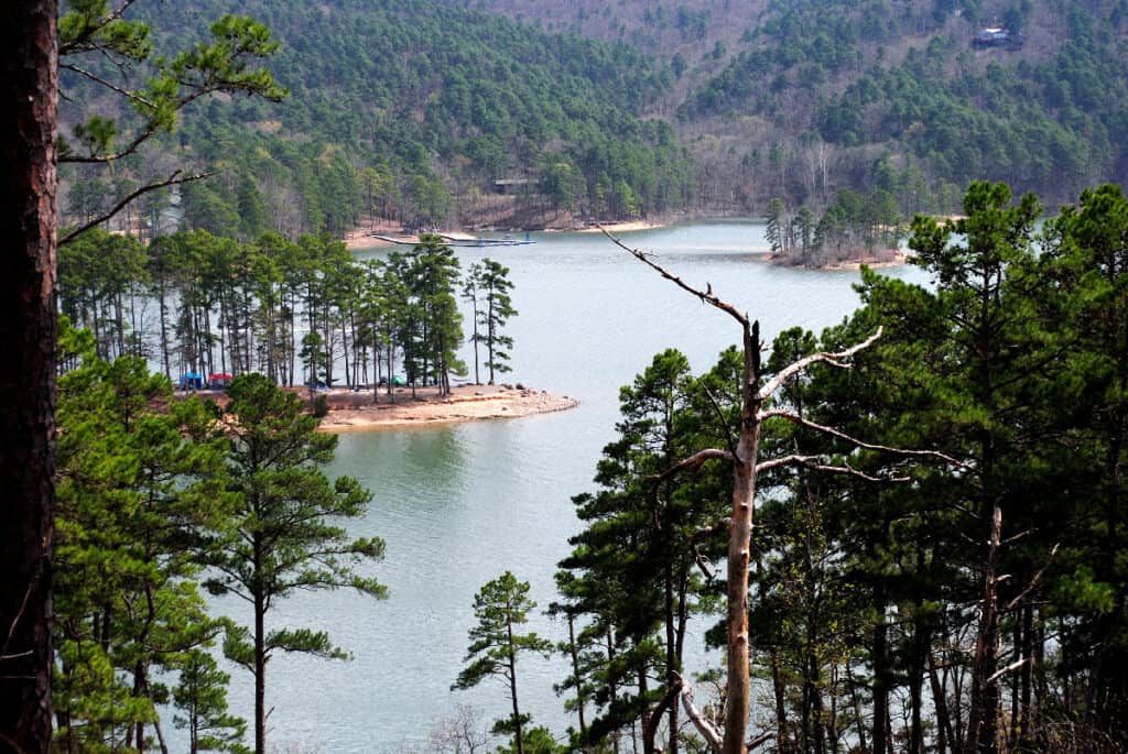
Located just outside the resort town of Hot Springs, Lake Ouachita is the largest man-made lake in Arkansas. Also known officially as Blakely Mountain Dam Reservoir, this freshwater reservoir possesses a total surface area of 40,000 acres.
That makes Lake Ouachita the largest lake contained entirely within the state of Arkansas, as the slightly larger Bull Shoals Lake also extends into Missouri. Lake Ouachita was built to control flooding and to provide hydroelectric power to the region. Today, it also features world-class fishing and recreation opportunities.
At full pool, Lake Ouachita stands approximately 578 feet above sea level and features 690 miles of shoreline. However, the reservoir features an overflow emergency spillway that releases water if the surface elevation exceeds 592 feet above sea level. Just below this maximum capacity, the lake increases in size to 48,300 acres of water and 975 miles of shoreline.
When full, the deepest point in the lake measures around 200 feet deep. This makes Lake Ouachita the deepest lake in Arkansas. That said, most parts of the lake average around 50 feet deep. The lake resides entirely within the Ouachita National Forest. Meanwhile, the public area surrounding Lake Ouachita encompasses an area of around 82,000 acres.
The U.S. Army Corps of Engineers originally designed Lake Ouachita to generate power, control flooding, and provide water to Arkansas residents for agricultural irrigation and personal use. Today, the lake also provides a host of recreational opportunities. Some popular water sports include scuba diving, swimming, skiing, boating, and kayaking. The surrounding Lake Ouachita public area features plenty of hiking trails, parks, and campgrounds. Lake Ouachita also contains one of the greatest crystal veins worldwide.
The area around the lake produces large quantities of quartz crystals highly prized by mineral collectors. While the quartz mines located within the Ouachita National Forest are off-limits to the public, you can pay a small fee to visit one of the several public mines in the area. If you enjoy fishing, Lake Ouachita supports a thriving fishing scene. Available species include crappie, bream, catfish, walleye, and world-class striped bass.
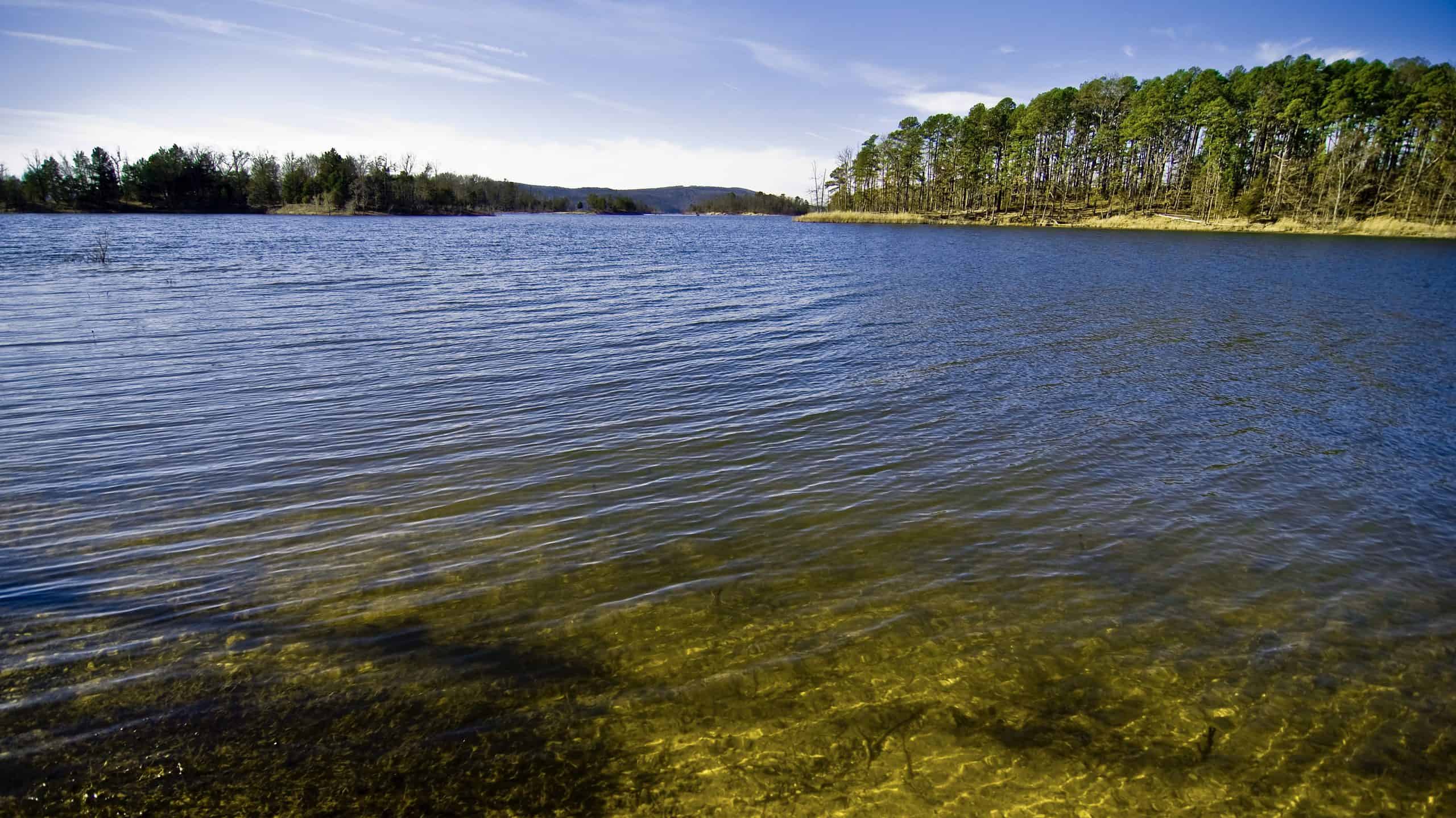
Lake Ouachita is the largest man-made lake in Arkansas.
©Barbara Kalbfleisch/Shutterstock.com
Where Is Lake Ouachita Located on a Map?
Lake Ouachita is within the Ouachita National Forest. It is located around 13 miles away from the “spa city” of Hot Springs, and close to Lake Hamilton and Lake Catherine.
History of Lake Ouachita
Before the Reservoir
Prior to the construction of Lake Ouachita, the area where the lake now resides looked very different. Before 1948, the Ouachita River wound unobstructed through the Ouachita Valley, passing mountains covered in pine and mixed hardwood forests. For thousands of years, various Native American tribes lived within the valley.
The Caddo, Osage, Tensas, Chickasaw, and Choctaw represent just a few of the tribes that lived along the river. In fact, the Ouachita River and Lake both get their name from the Washita tribe, which historically called the Ouachita Valley home. These various tribes hunted and lived along the river and took advantage of the healing properties of the nearby hot springs.
Over the years, several different countries staked territorial claims to the Ouachita Valley. France claimed the land as early as 1673 but later ceded the land to Spain in the 1763 Treaty of Paris. France briefly regained control of the land in 1800 but quickly sold the land (and everything west to the Pacific Ocean) to the United States via the Louisiana Purchase.
The following few decades saw the gradual development of the surrounding land for farming and residential communities. In particular, the town of Hot Springs to the east of the lake boomed into a popular tourist town. The U.S. Congress designated the land as a federal reservation in 1832, and various industries cropped up around the town’s natural hot springs. During the early 20th century, the town grew into a hub for gambling, baseball spring training, and tourism.
The Creation of the Reservoir
In the late 19th century, the Ouachita River’s stream flow varied widely depending on the time of year and weather conditions. This variation led to significant problems, including flooding and difficulty maintaining proper irrigation and water storage. Around that time, the U.S. Congress authorized surveys of the river to find a long-term solution to these problems.
The surveys concluded that a dam could help control flooding, improve water storage and irrigation, and generate power for the region. In the early 1920s, Arkansas Power and Light began buying the land where Lake Ouachita is now located. It built several smaller dams in the area before setting its sights on the Blakely Mountain Dam.
The U.S. Army Corps of Engineers began construction on the Blakely Mountain Dam in 1948. However, the leadup to the project faced several problems. For example, many local residents objected to the purchase of their land by the government for – what they viewed as – substandard prices. Additionally, the planned location of the reservoir was covered by acres of forest. To clear the land, workers constructed over 20 sawmills in the area to harvest the timber on site.
Additionally, many roads in the area had to be rerouted to avoid being flooded by the reservoir. Work on the dam officially wrapped up in 1953. Upon completion, the Blakely Mountain Dam measured 231 feet tall and 1,100 feet long. Construction of the power plant on site began in 1953 and finished in 1955. The power plant can generate around 75 megawatts of electricity, enough to power 38,000 homes.
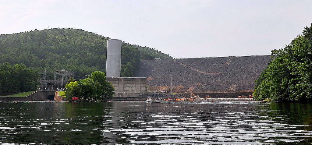
Blakely Mountain Dam was completed in 1953 measuring 231 feet in height and 1,100 feet in length.
©William T. Allen IV, CC BY-SA 3.0 <https://creativecommons.org/licenses/by-sa/3.0>, via Wikimedia Commons – Original / License
Lake Ouachita Geography
Lake Ouachita straddles Garland and Montgomery counties in west-central Arkansas. The Ouachita River flows into the western part of the reservoir and exits the eastern part of the reservoir via the Blakely Mountain Dam. Several other smaller waterways flow into the reservoir, including Arnold Creek, Walnut Creek, Caney Creek, Muddy Creek, and Redbank Creek. A few other major lakes reside within the area, including Lake Hamilton, Lake Catherine, and DeGray Lake.
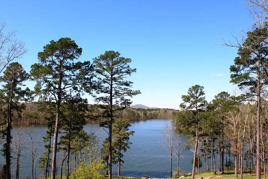
Lake Ouachita is nestled within the Ouachita Valley. The Ouachita Mountains surround the reservoir on all sides. Most of the mountains in the range measure around 1,500 to 2,500 feet tall. Mount Magazine – the tallest peak in the range – stands slightly taller at 2,753 feet. Pine, oak, and hickory trees cover most of the mountains and surrounding undeveloped lowland areas. Additionally, the Ouachita range represents the only place in the world where you can find the rare maple-leaf oak.
The Ouachita National Forest covers 1.8 million acres of the range and encompasses the entirety of the reservoir. Within the lake itself, you can find around 200 individual islands that did not fully flood after the construction of the Blakely Mountain Dam. Additionally, aquatic vegetation such as Eurasian milfoil and hydrilla cover around 10% of the lake
The largest nearby town, Hot Springs, rests just a few miles east of the lake. Meanwhile, the greater Lake Ouachita recreation area contains around 93 campsites and numerous trails, swimming areas, and marinas. The recreation area also features a visitor center, rental cabins, picnic areas, and playgrounds.
The greater Lake Ouachita recreation area contains around 93 campsites and numerous trails, swimming areas, and marinas.
©iStock.com/Kathy Byrd
Lake Ouachita Reviews
Visitors to Lake Ouachita share mostly positive reviews of their time spent at the lake. The lake itself is well-maintained, and the water is extremely clear. If you enjoy getting out on the water, you can swim in the lake or rent a paddle boat or kayak for a modest fee.
Additionally, Lake Ouachita offers anglers excellent fishing opportunities. In particular, the lake boasts some of the best-striped bass fishing in the country. The lake also allows spearfishing, a popular sport among both scuba divers and free divers.
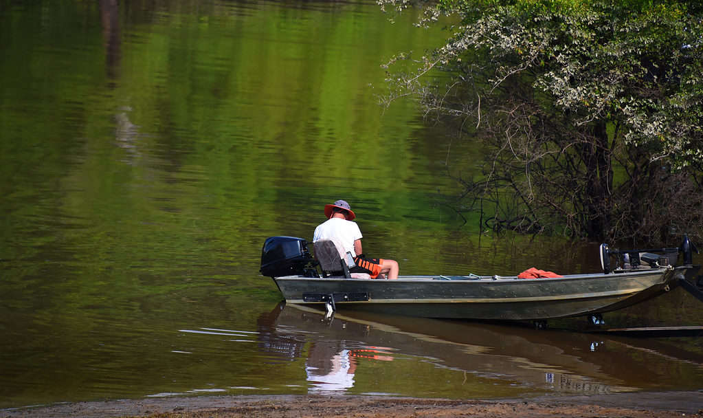
Lake Ouachita offers anglers excellent fishing opportunities with some of the best-striped bass fishing in the country.
©Bonita R. Cheshier/Shutterstock.com
If you prefer to stay out of the water, you can enjoy one of the many hiking trails in the area. The eagle tour offers visitors a chance to spot resident birds such as bald eagles and other birds of prey. Alternatively, you can visit nearby Hot Springs and take a dip in the hot springs, visit a spa, or enjoy food and drinks at one of the local dining establishments.
While most reviews of Lake Ouachita are positive, some people did not enjoy their stay. Most negative reviews mention that the accommodations around the lake need upkeep. Some of the cabins and other rental properties may lack certain amenities or require cleaning.
Additionally, the lake still contains a large number of underwater trees. If you take a boat out on the lake, always make sure you still to clearly marked boating paths or a local guide for directions.