
How big is Canada? The short, oversimplified answer is… very big! But let’s take a much more detailed look at Canada’s size, how it compares with other large nations, and much more.
How Many Square Miles and Square Kilometers Is Canada?
Canada’s total area covers 3,855,103 square miles or 9,984,670 square kilometers. It is the second largest country in the world by total area, trailing only Russia.
The total area of North America is 9,540,000 square miles (24,709,000 square kilometers). Canada accounts for more than 40% of North America’s total area.
However, while Canada is the second-largest nation in terms of total area, it drops two spots when only considering land area. Canada has the world’s largest area of freshwater lakes. Around 20% of the world’s freshwater is found in Canada.
Almost nine percent of Canada’s total area is covered by water. Canada’s land area measures 3,511,021 square miles (9,093,507 square kilometers). Its land area is smaller than that of Russia, the United States, and China.
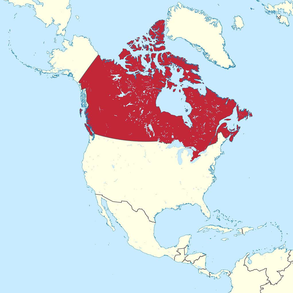
Canada’s vast expanse makes it the second-largest country in the world in terms of total area.
©TUBS / CC BY-SA 3.0 – License
How Many Acres is Canada?
A FIFA soccer field is about 1.8 acres in size. An American football field (without the end zones) measures approximately one acre. There are 640 acres in a square mile.
Canada’s total area spans 2,467,265,920 acres. Only five nations in the world have total areas that exceed two billion acres. Along with Canada, those countries include Russia, the United States, China, and Brazil.
Length and Width of Canada
Canada’s longest distance from north to south is 2,879 miles (4,634 kilometers) from Cape Columbia (Ellesmere Island), Nunavut, to Middle Island (Lake Erie), Ontario. That is about 1.75 times the greatest north-to-south distance in the conterminous United States (1,650 miles / 2,660 kilometers).
The widest east-to-west measurement in the country is 3,426 miles (5,514 kilometers) from Cape Spear, Newfoundland and Labrador, to the Yukon’s border with the U.S. state of Alaska. That is around 625 miles further than the longest east-to-west distance in the conterminous U.S.
Canadian Provinces
Canada is divided into ten provinces and three territories. The provinces include Newfoundland and Labrador, Nova Scotia, Prince Edward Island, New Brunswick, Quebec, Ontario, Manitoba, Saskatchewan, Alberta, and British Columbia.
Quebec is the largest province in terms of total area. The province spans 595,391 square miles (1,542,056 square kilometers).
The smallest province is Prince Edward Island, at just 2,185 square miles (5,660 square kilometers).
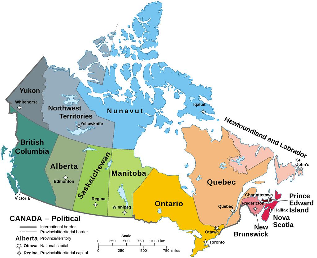
Canada is divided into ten provinces and three territories.
©Hogweard / Public domain – License
Canadian Territories
Nunavut, the Northwest Territories, and the Yukon comprise the three Canadian territories.
The largest territory is Nunavut, which covers 808,185 square miles (2,093,190 square kilometers). The territory accounts for about one-fifth of Canada’s total land area. It is also the nation’s newest territory. Nunavut was formed from the Northwest Territories in 1999.
The Yukon is the smallest territory, but it is still bigger than Canada’s largest province. Yukon spans 186,272 square miles (482,443 square kilometers).
How Big Is Canada Compared to the United States?
The United States’ total area covers 3,796,742 square miles (9,833,517 square kilometers). That equates to 2,429,914,880 acres.
Canada is 58,361 square miles larger than the United States. The square mileage difference between the two countries is slightly larger than the U.S. state of Illinois.
How Big Is Canada Compared to Russia?
With a total area of 6,601,670 square miles (17,098,246 square kilometers), Russia is the largest country on the planet by a wide margin. It is over 1.7 times the size of Canada.
Russia’s total area exceeds that of Canada by 2,746,567 square miles (7,113,576 square kilometers). That is larger than the provinces of British Columbia, Alberta, Saskatchewan, Manitoba, Ontario, Quebec, New Brunswick, Prince Edward Island, and Nova Scotia combined.
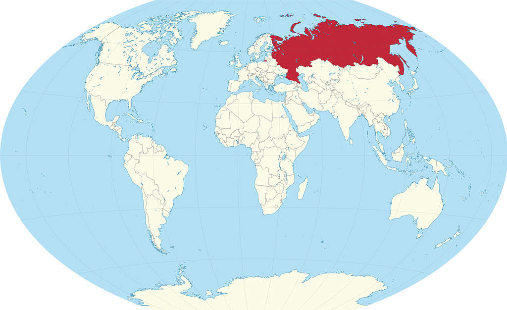
Russia extends nearly halfway around the Northern Hemisphere.
©TUBS / CC BY-SA 3.0 – License
How Big Is Canada Compared to Antarctica?
If Antarctica was a country, it would be the second largest nation on Earth, behind only Russia. The continent’s total area spans roughly 5,480,000 square miles (14,200,000 square kilometers), which is slightly shy of one and a half times the size of Canada.
Antarctica outsizes Canada by 1,624,897 square miles (4,208,464 square kilometers). That is nearly the size of Newfoundland and Labrador, Quebec, Ontario, Manitoba, and Saskatchewan combined.
It should be noted that while Antarctica is not a nation, seven countries have made territorial claims in Antarctica. Those nations include Argentina, Australia, Chile, France, New Zealand, Norway, and the United Kingdom. Most other nations do not recognize these claims.
Percentage of the World’s Area
Canada accounts for about 1.95% of the world’s total area. Russia contains about 3.35% of the world’s total area, while the United States claims about 1.93% of that area.
Water covers more than 70% of the Earth. Canada accounts for around 6.1% of the world’s land area. Russia contains around 11% of the land area on Earth, while the U.S. accounts for 6.14% of the world’s land area.
Canada’s Borders
Canada shares a land border with just one other nation: the United States. At 5,525 miles (8,891 kilometers) long, the Canada-United States border is the longest terrestrial border in the world.
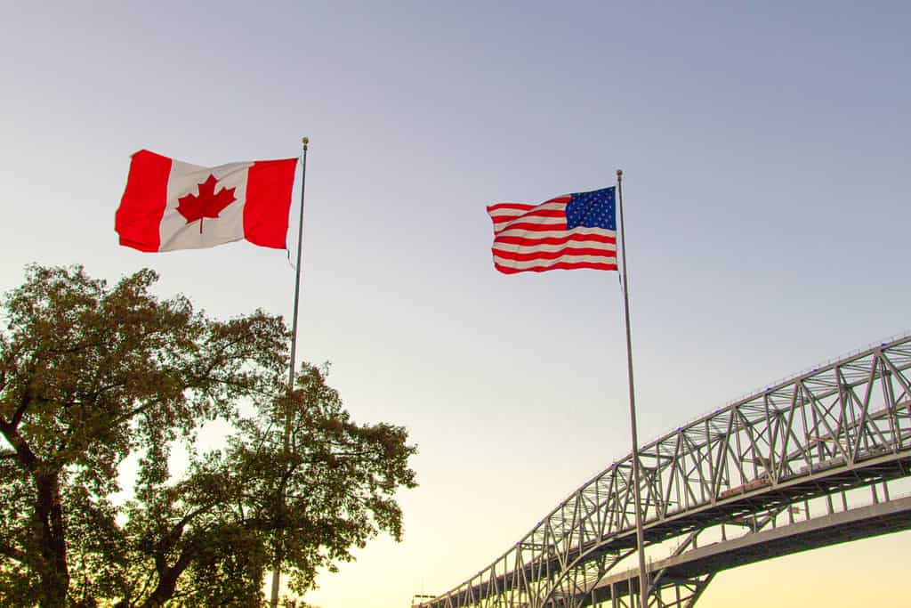
The land border between Canada and the U.S. is the world’s longest.
©ehrlif/Shutterstock.com
Eight Canadian provinces and territories border the United States. Ontario has the longest border with the U.S., while Alberta has the shortest shared boundary with the U.S.
| Province/Territory | U.S. Border Miles | U.S. Border Kilometers |
|---|---|---|
| Ontario | 1,682 | 2,727 |
| British Columbia | 1,347 | 2,168 |
| Yukon | 786 | 1,244 |
| Quebec | 505 | 813 |
| Saskatchewan | 393 | 632 |
| New Brunswick | 318 | 513 |
| Manitoba | 309 | 497 |
| Alberta | 185 | 298 |
Thirteen U.S. states border Canada. Alaska has the longest shared boundary with Canada by far. It is more than double the length of the state with the next longest Canadian border (Michigan). Pennsylvania has the shortest boundary with Canada.
| U.S. State | Canadian Border Miles | Canadian Border Kilometers |
|---|---|---|
| Alaska | 1,538 | 2,475 |
| Michigan | 721 | 1,160 |
| Maine | 611 | 983 |
| Minnesota | 547 | 880 |
| Montana | 545 | 877 |
| New York | 445 | 716 |
| Washington | 427 | 687 |
| North Dakota | 310 | 499 |
| Ohio | 146 | 235 |
| Vermont | 90 | 145 |
| New Hampshire | 58 | 93 |
| Idaho | 45 | 72 |
| Pennsylvania | 42 | 68 |
Other International Borders
Along with the terrestrial border with the U.S., Canada shares maritime borders with two other countries. The nation shares a maritime border with France. The border is between the Newfoundland and Labrador province and the Saint Pierre and Miquelon islands. This archipelago is a territorial overseas collectivity of France.
Canada also shares a maritime boundary with Denmark. Greenland is an autonomous territory of Denmark. The maritime border between the Danish island and Canada stretches 2,462 miles (3,962 kilometers), making it the longest maritime border in the world.
The two nations also came to an agreement over the long-disputed Hans Island, although “disputed” may not be the correct word. The two nations warred over the island, but only through flags and alcohol. One nation would plant a flag on the island and leave a bottle of its signature spirits. Then, the other nation would replace that flag with its own and leave its signature bottle. This so-called “Liquor War” ended with a 2022 agreement split the island, with each nation claiming roughly half as its sovereign territory. The agreement was appropriately celebrated with whiskey.
The border between Canada and Greenland is the world’s longest maritime boundary.
©Sanjay Rao / CC0 – License
Population
Canada’s population is estimated to be 39,858,480. While it is the second largest country in terms of total area, it is the 37th most populous nation in the world. Canada’s entire population is only slightly larger than the U.S. state of California, which has 39,029,342 residents.
Russia is the ninth most populous country with 146,424,729 residents, while the United States is the third most populous nation with 333,287,557 residents.
China is the world’s most populous country, with 1,411,750,000 residents, nearly 35.5 times the size of Canada’s population.
Population Density
With its expansive size and relatively small population, Canada has a low population density. Population density is the calculation of the number of people per square mile or kilometer. Canada’s population density is 10.9 people per square mile or 4.2 people per square kilometer. It ranks 236th among the world’s nations in terms of population density.
Russia ranks 187th in terms of population density, with 21.8 people per square mile or 8.4 people per square kilometer.
The United States ranks 148th in terms of population density. The U.S. has 87 people per square mile or 33.6 people per square kilometer.

Most of Canada is uninhabited wilderness.
©AndreAnita/Shutterstock.com
Largest Cities
Canada has 34 major cities (populations over 100,000). Over 80% of the nation’s populace resides in cities.
The largest Canadian city is Toronto, with 2,794,356 residents. That is comparable to the size of Chicago in the United States.
Toronto is North America’s fourth most populous city, trailing only Mexico City, New York City, and Los Angeles. The Greater Toronto metropolitan area is home to over 6.7 million residents.
Montreal, Canada’s second-largest city, has a population of 1,762,949, which is slightly larger than the U.S. city of Phoenix. The metro area surrounding Montreal is home to 4,291,732 residents. It is the world’s second-largest French-speaking city behind Paris.
Canada’s other cities with over one million residents include Vancouver, Calgary, Edmonton, and Ottawa–Gatineau.
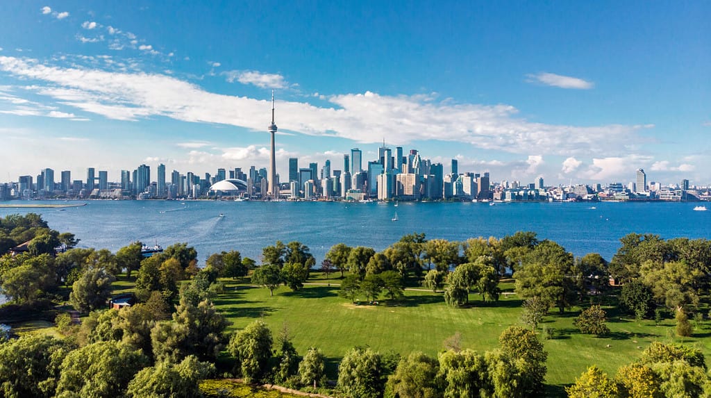
Toronto is Canada’s largest city.
©R.M. Nunes/Shutterstock.com
Crown Lands
Canada’s vast expanse is largely Crown land. Only 11% of Canada’s area is privately owned. The remaining 89% is Crown land, meaning it is owned and managed by the federal or provincial governments. Around 41% of Canada’s territory is federal crown land, while 48% is provincial crown land.
Most of the federally managed land is in the territories. Only about four percent of land in the provinces is federally owned. Provincial government’s ownership of land varies from less than two percent in Prince Edward Island to 95% in Newfoundland and Labrador.
National and provincial parks, Indian reserves, federal military bases, and provincial forests make up much of Canada’s crown land.
Around 90% of the nation’s forests are owned and managed by provincial and territorial governments. The federal government owns an additional four percent of Canada’s forests, leaving just six percent in the hands of private landowners.
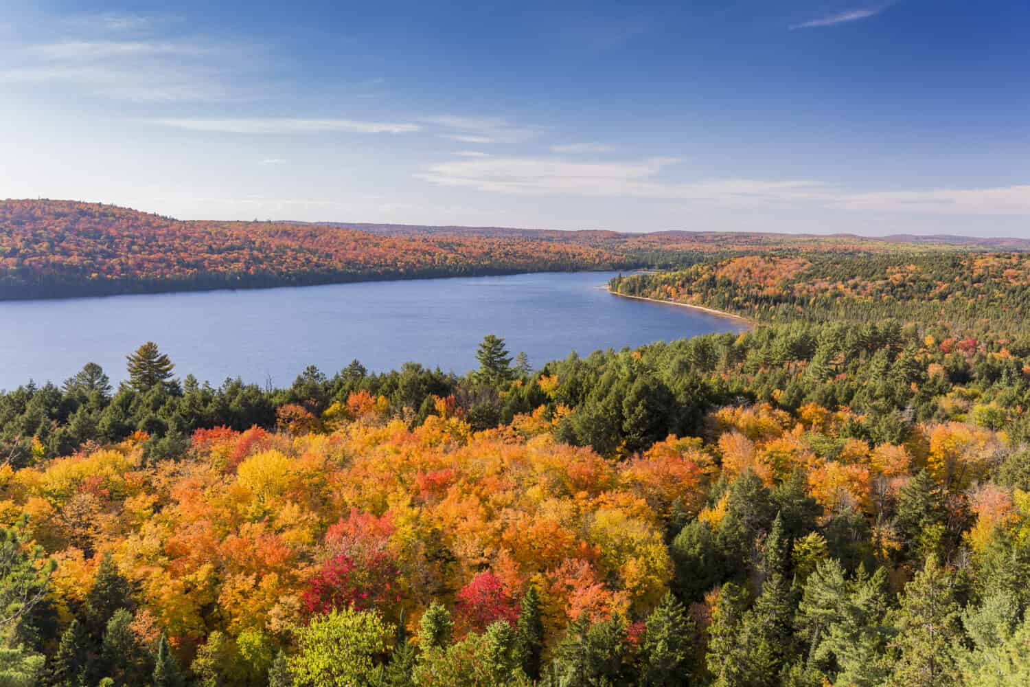
Parks such as Algonquin Provincial Park in southeastern Ontario are part of Canada’s crown land.
©Brian Lasenby/Shutterstock.com
Time Zones
Canada spans six time zones. From east to west, the country’s time zones are:
- Newfoundland Time Zone
- Atlantic Time Zone
- Eastern Time Zone
- Central Time Zone
- Mountain Time Zone
- Pacific Time Zone.
Most of the nation observes Daylight Saving Time. Much of Saskatchewan and the Yukon Territory do not observe the annual time change but instead remain on standard time throughout the year.
Canada’s Official National Symbols
Maple Leaf
The maple leaf is the de facto symbol of Canada and is one of its most recognized icons. It occupies the center of Canada’s flag. The maple leaf has been a symbol of Canada since the mid-nineteenth century under British rule. The symbol has also appeared on military uniforms and the headstones of fallen soldiers. It also appeared on the penny, but the coin’s production was stopped in 2013. The sugar maple was named the official national tree of Canada in 1996.
Colors and Motto
The flag features red and white colors, which were named the official national colors of Canada in 1921.
Canada’s official motto is A Mari Usque Ad Mare (From sea to sea). It was adopted on the same date as the national colors in 1921.
National Anthem
“O Canada” is the official national anthem of Canada. It received that official designation in 1980, though the song itself dates back to 1880 when it was commissioned by Lieutenant Governor of Quebec Théodore Robitaille for the Saint-Jean-Baptiste Day ceremony. The song was originally written in French. Robert Stanley Weir’s English version of the song in 1908 served as the basis for what would become Canada’s official national anthem.
National Animals
The North American beaver has been the official animal symbol of Canada since 1975. Beaver pelts were the main economic attraction that drew settlers to Canada in the 1700s. By the mid-1800s, the beaver was teetering on extirpation in Canada. However, conservation efforts have allowed Canada’s national animal to make a remarkable comeback.
The Canadian horse was added as a second national animal in 2002. The horse’s origins date back to 1665 when the king of France sent horses to what was then known as New France. The horses were of mixed origin. These horses were isolated from others in breeding and gradually became a new breed altogether–the Canadian horse.
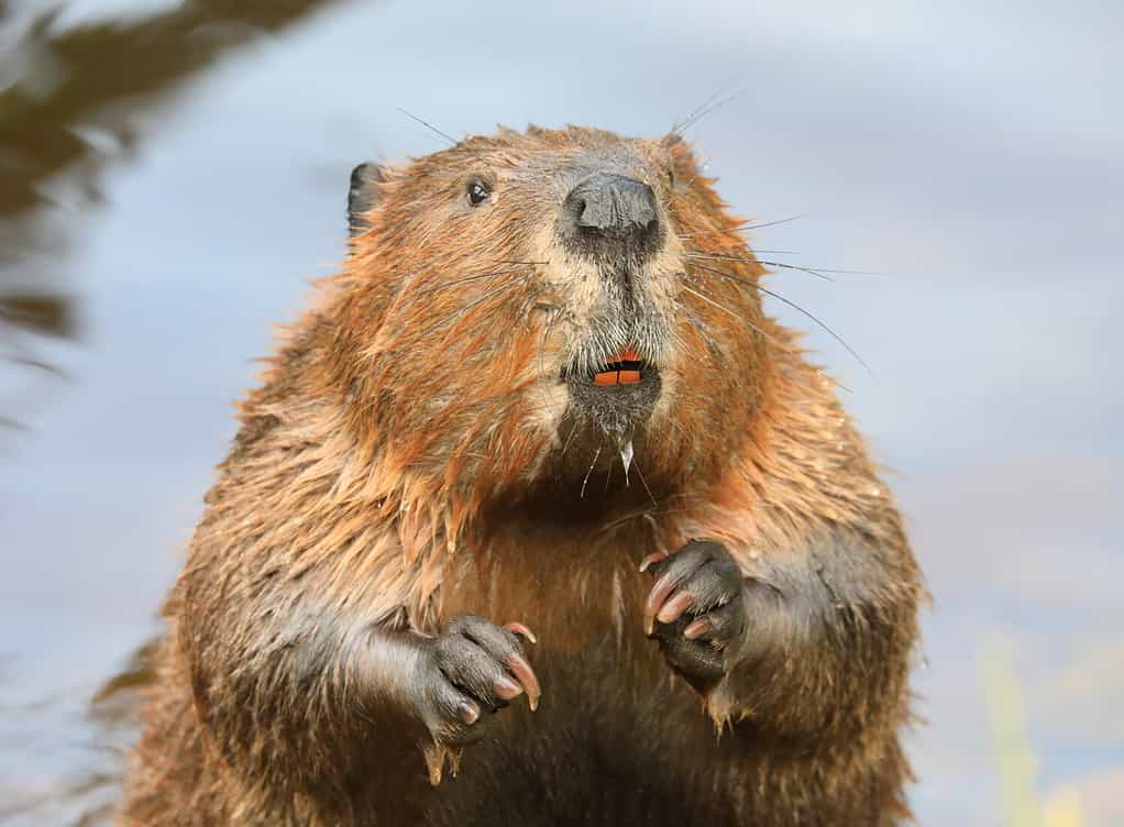
The North American beaver is a national symbol of Canada.
©Vlad G/Shutterstock.com
National Sports
Canada’s two national sports were both named in 1994. Lacrosse is the national summer sport, and ice hockey is the national winter sport.
Other Fun Facts About Canada
- Canada is bigger than the entire European Union.
- Canada has the longest coastline in the world at 125,567 miles (202,080 kilometers). The next longest coastline belongs to Norway, but it is 193,700 miles shorter than that of Canada.
- Canada is home to the largest freshwater island in the world. Ontario island of Manitoulin covers an area of 1,068 square miles (2,766 square kilometers).
- At 1,815 feet (553.3 meters) tall, the CN Tower in Toronto is the tallest free-standing structure on land in the Western Hemisphere.
- The Northwest Territories houses valuable diamond mining operations, the largest of which is Diavik, which produces between six and seven million carats each year. Canada is the fifth-largest diamond producer in the world by volume and the third-largest in terms of value.
- Canada became an independent nation on July 1, 1867. It would not have an official flag for almost another 100 years, though. The flag was officially adopted in 1965, replacing the Union Jack.
- Canada has two official languages: English and French.
- Canada’s capital, Ottawa, is the second coldest capital city in the world, trailing only Moscow, Russia.
The photo featured at the top of this post is © Sus2021 / CC BY-SA 4.0 – License / Original


How to Add Us to Google News


Thank you for reading! Have some feedback for us? Contact the AZ Animals editorial team.