Below you can find a complete list of Southern Ocean animals.
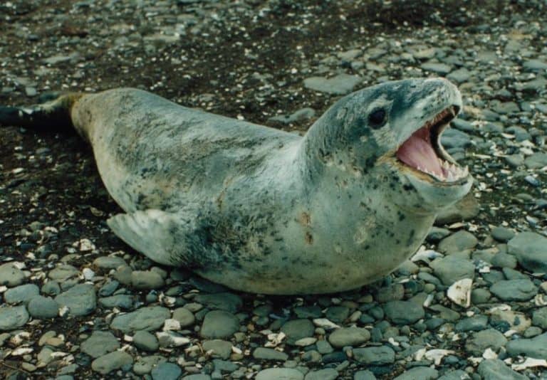
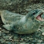
Leopard Seal
Spotted apex hunter of the pack ice
Spotted apex hunter of the pack ice
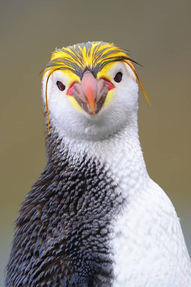
Macquarie's white-faced crested king
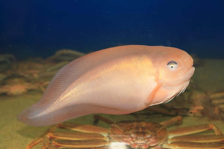
Snailfishes: clingers of the cold deep
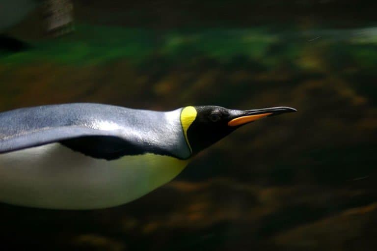
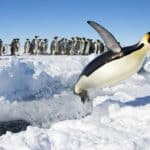
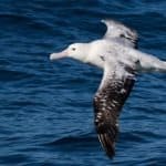
Royal diver of the Southern Ocean
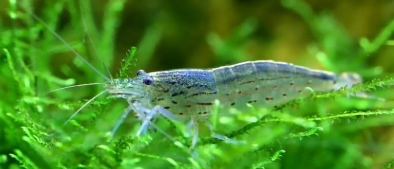
Small crustaceans, big ocean jobs
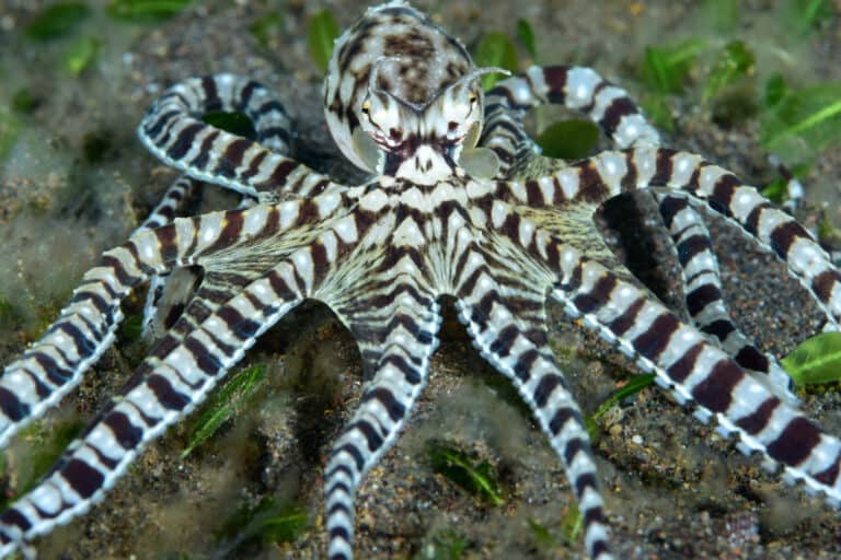
Eight arms, endless ingenuity
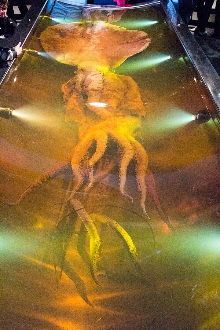
Antarctica's hooked, big-eyed giant
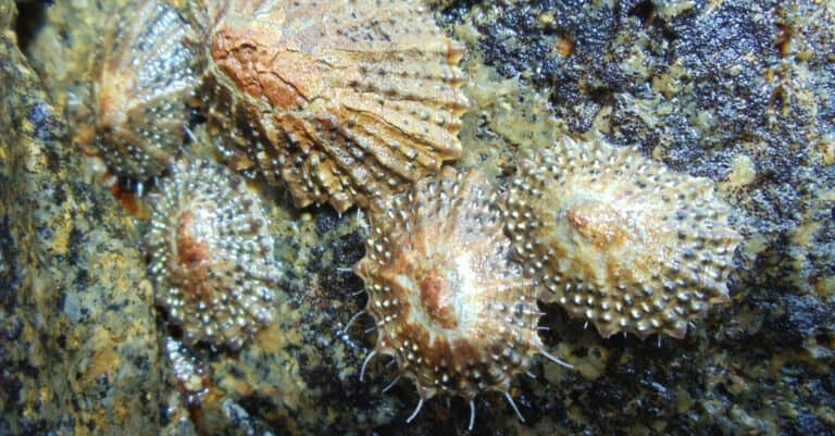
Cling hard, graze smart, ride the tide.
Probe the seafloor, chimaera-style
Strapped for the ice, built for the surf
The Southern Ocean is the circumpolar oceanic region surrounding Antarctica-generally south of about 60°S-where the Antarctic Circumpolar Current links the Atlantic, Pacific, and Indian Oceans and Antarctic-influenced waters dominate.
Encircling Antarctica as a continuous ring of sea, the Southern Ocean is the only ocean defined primarily by a powerful current rather than by continental boundaries. The Antarctic Circumpolar Current (ACC) flows eastward around the globe, connecting the Atlantic, Pacific, and Indian basins and forming a dynamic system of fronts and jets that separate cold Antarctic waters from relatively warmer subantarctic waters.
Despite its frigid temperatures, the Southern Ocean is among the planet's most biologically important marine regions. Strong winds, upwelling, and seasonal sea-ice growth and melt help deliver nutrients to sunlit surface waters, fueling intense phytoplankton blooms that support vast populations of Antarctic krill. Those krill, in turn, underpin food webs that include penguins and other seabirds, seals, and great whales, while the region also plays an outsized role in global climate through heat and carbon uptake and the formation of Antarctic Bottom Water.
Etymology: "Southern Ocean" is a descriptive geographic name for the ocean surrounding Antarctica at Earth's southernmost latitudes. The word "ocean" ultimately comes from an ancient Greek name associated with the sea, and "southern" denotes its location around the South Pole and Antarctica.
Antarctic Circumpolar Current, nutrient-rich upwelling, vast sea ice, krill-based food webs, whales/seals/seabirds, some of the planet's stormiest seas
The Southern Ocean encircles Antarctica in the high southern latitudes, forming a continuous, storm-dominated marine ring where cold, nutrient-rich waters circulate eastward around the continent and connect the Atlantic, Pacific, and Indian Oceans via the Antarctic Circumpolar Current.
Factorian Deep, South Sandwich Trench (Scotia Sea sector)
Antarctica: no country owns it; coastline managed by the Antarctic Treaty System; territorial claims paused.
Adjacent via the Australian Antarctic Territory; administers subantarctic islands (e.g., Heard and McDonald Islands, Macquarie Island).
Adjacent via the Ross Dependency and subantarctic islands (e.g., Auckland and Campbell Islands).
Nearest South American state to the Pacific/Drake Passage sector; asserts Antarctic territorial claim and has subantarctic access routes.
Nearest South American state to the Scotia/Drake Passage sector; asserts Antarctic territorial claim.
Administers South Georgia & the South Sandwich Islands; asserts Antarctic territorial claim (British Antarctic Territory).
Adjacent via Adélie Land claim; administers subantarctic islands (Kerguelen, Crozet) in the southern Indian Ocean.
Adjacent via Queen Maud Land claim and Bouvet Island in the South Atlantic sector.
Administers Prince Edward Islands (Marion and Prince Edward) in the southern Indian Ocean approaches.
To the south it is bounded by the Antarctic continent, its continental shelf, and major ice shelves; to the north it transitions into the Atlantic, Indian, and Pacific Oceans, commonly defined by the IHO as northward to about 60°S (closely aligned with the Antarctic Polar Front/Antarctic Convergence in many places). Key gateways include Drake Passage (to the Pacific/Atlantic sectors) and the subantarctic fronts that separate it from warmer waters.
Surface avg: ~ 0 to 2 °C (often near -1.8 to 1 °C south of the Polar Front; ~2-6 °C in subantarctic waters)
Deep avg: ~ 0 to 1.5 °C (dominantly cold deep waters; locally slightly warmer intrusions at depth north of major fronts)
Typical open-ocean surface salinity ~33.0-34.5 PSU, often lowered by sea-ice melt and precipitation; deeper waters commonly ~34.6-34.8 PSU. Strong regional contrasts across fronts and near ice margins.
Strong seasonality: widespread winter sea-ice formation and surface cooling to near freezing; summer surface warming and ice retreat, especially north of the Antarctic Polar Front
Dominated by the Antarctic Circumpolar Current (ACC) flowing eastward around Antarctica; bounded by major frontal systems (Subantarctic Front, Polar Front/Antarctic Convergence, Southern ACC Front). Near Antarctica, the Antarctic Coastal Current (East Wind Drift) flows westward; Weddell and Ross gyres are major subpolar circulation features. ACC interactions with topography generate jets, meanders, and eddies that enhance mixing and transport between basins.
Mixed (diurnal-semidiurnal) tides with strong spatial variability. Generally moderate in the open Southern Ocean, but can be amplified on continental shelves and in embayments (e.g., Weddell and Ross Sea shelves) where tidal currents can be strong and contribute to mixing, sea-ice motion, and formation of dense shelf waters.
Key water masses include Antarctic Surface Water (cold, seasonally modified by sea-ice melt/freezing), Circumpolar Deep Water (CDW; relatively warm and nutrient-rich, transported within the ACC), Antarctic Intermediate Water (AAIW; formed in subantarctic zones and exported northward), and Antarctic Bottom Water (AABW; very cold, dense water formed mainly on Antarctic shelves and exported into global abyssal basins). Overall, waters are oxygen-rich at depth and nutrient-rich throughout, with high macronutrients but often iron-limited productivity.
Strongly seasonal. Summer: a fresher, warmer surface mixed layer from sea-ice melt overlies colder, saltier waters, increasing stratification and promoting phytoplankton blooms. Winter: deep mixed layers due to cooling, wind-driven mixing, and brine rejection during sea-ice formation, reducing stratification and ventilating intermediate/deep layers. Persistent frontal zones create sharp horizontal and vertical gradients, and CDW can shoal toward the surface near fronts and shelf breaks.
Major wind-driven upwelling associated with the ACC and Antarctic Divergence, bringing Circumpolar Deep Water closer to the surface and supplying nutrients across much of the circumpolar belt. Additional localized upwelling occurs at shelf breaks (e.g., Amundsen and Bellingshausen Seas) and where ACC interacts with topography (ridges/plateaus), enhancing eddy-driven vertical exchange. Despite high nutrients, primary production can be limited by iron availability except near continental margins, islands, and dust/iceberg meltwater inputs.
Extensive seasonal sea-ice cover drives strong freshwater/heat fluxes and brine rejection, influencing deep water formation (AABW) that helps power global overturning circulation. Very strong westerly winds and frequent storms generate high waves and intense mixing. The region exhibits high macronutrient concentrations with frequent iron limitation, leading to episodic, highly productive blooms near fronts, islands, and ice-edge zones. Rapid climate-driven changes include warming and shoaling of CDW in some sectors, sea-ice variability, and increased meltwater/iceberg influence on stratification and ecosystems.
The Southern Ocean is a cold, wind-dominated, high-nutrient marine region encircling Antarctica, strongly influenced by the Antarctic Circumpolar Current (ACC) and persistent westerly winds. Surface waters are generally near-freezing for much of the year (especially south of the Polar Front), with sharp oceanic fronts separating colder Antarctic waters from relatively milder subantarctic waters. The region is highly productive in spring-summer due to increasing light and seasonal sea-ice melt that stabilizes the surface layer and supplies micronutrients (notably iron), supporting large krill-based food webs.
Seasonality is extreme in light, sea ice, and mixing. In austral summer (roughly Dec-Feb), longer daylight, retreating sea ice, and stratification from meltwater promote phytoplankton blooms and peak biological activity; surface waters warm slightly but remain cold. In autumn (Mar-May), cooling and increasing winds deepen the mixed layer and productivity declines as light decreases. In winter (Jun-Aug), very short daylight, intense wind-driven mixing, and widespread sea-ice expansion suppress primary production; the ocean is coldest and most strongly storm-influenced. Spring (Sep-Nov) features rapidly increasing light and initial ice retreat, often triggering the first major bloom pulses along the ice edge and frontal zones.
The Southern Ocean is one of the stormiest ocean basins on Earth, dominated by frequent, fast-moving extratropical cyclones that track west-to-east along the westerlies and intensify along strong temperature gradients near the Polar Front and sea-ice edge. Peak storminess generally occurs in austral winter and shoulder seasons, with strong winds, large waves, and rapid weather changes common year-round. Tropical-style hurricanes/typhoons do not occur due to cold sea-surface temperatures; instead, polar lows can occasionally develop at high latitudes during winter, producing localized intense winds and snowfall.
Sea ice is strongly seasonal and highly variable by sector. In austral winter, sea ice expands outward from Antarctica to cover a large portion of the Southern Ocean, with extensive pack ice and frequent formation of coastal polynyas that produce dense water. In austral summer, sea ice retreats substantially, persisting mainly in the Weddell and Ross Seas and in sheltered or high-latitude areas, with an active marginal ice zone where meltwater enhances stratification and supports blooms. Ice conditions influence navigation and ecosystem timing, and interannual variability can be large across different sectors of the ocean.
The Southern Ocean is a cold, highly seasonal marine system encircling Antarctica, structured by the Antarctic Circumpolar Current and a strong oceanic frontal system. Its ecology is defined by extensive sea-ice cover (winter expansion and summer retreat), nutrient-rich waters with intense but short-lived phytoplankton blooms, and food webs that funnel primary production into immense mid-trophic biomass-especially Antarctic krill-supporting globally important populations of seabirds, seals, and baleen whales. Despite comparatively low temperatures and generally lower species richness than temperate/tropical oceans, the region has high endemism and distinctive adaptations (e.g., ice-associated life cycles, antifreeze proteins, and specialized benthic communities on continental shelves).
High ecological importance and endemism with exceptionally high seasonal productivity and biomass (notably krill-centered food webs). Species richness is lower than many warmer oceans, but endemism is elevated across fishes (e.g., notothenioids/icefishes), invertebrates, and benthic shelf communities; biodiversity and community structure vary strongly by sea-ice conditions, fronts, depth, and proximity to Antarctic shelves and subantarctic islands.
Species count: ~8,000-10,000 described marine species in the Southern Ocean/Antarctic region (with substantial additional undescribed diversity, especially in benthic invertebrates and microbes).
Along the Antarctic continental shelf and around subantarctic islands, the neritic zone is dominated by cold, often ice-influenced coastal waters with strong seasonal light and sea-ice cycles. Polynya regions (recurring open-water areas within sea ice) and shelf-break upwelling concentrate nutrients and fuel intense spring-summer phytoplankton blooms. Kelp and macroalgae occur mainly around milder subantarctic coasts, while near Antarctica primary production is largely planktonic and ice-associated algae. This zone supports dense aggregations of Antarctic krill, coastal fishes (including icefishes and notothenioids), penguin colonies, and hauled-out seals, with productivity peaking during the ice retreat.
The pelagic Southern Ocean is structured by the Antarctic Circumpolar Current (ACC) and a series of fronts (e.g., Subantarctic and Polar Fronts) that separate water masses and create mixing and upwelling of nutrient-rich deep waters. Despite high macronutrients, productivity is strongly seasonal and often limited by iron and light; large blooms occur where iron is supplied (island wakes, shelf margins, sea-ice melt, dust, and upwelling). Summer brings widespread phytoplankton growth supporting vast krill swarms, while winter shifts the system toward lower production and reliance on stored energy and ice-associated food sources. The open ocean is a major foraging arena for whales and seabirds, and a key region for global carbon uptake and export as sinking organic matter.
The benthic zone spans the Antarctic shelf, slope, and deep basins, shaped by cold, stable temperatures, iceberg scouring in shallow areas, and strong seasonal delivery of organic matter from surface blooms. Shelf habitats can be highly diverse, with slow-growing sponges, soft corals, bryozoans, echinoderms, and mobile invertebrates forming complex seafloor communities where scouring creates a patchwork of successional stages. In deeper waters, food supply is lower and more episodic, so communities rely on detrital "marine snow," carcass falls (including whales), and localized chemosynthetic processes at rare seeps/vents. Benthic organisms often have long lifespans and low metabolic rates, making them sensitive to disturbance and changes in export production.
Near-bottom (demersal) waters over the shelf and slope support fishes adapted to freezing temperatures, including notothenioids and icefishes, many with antifreeze proteins and buoyancy adaptations. These predators feed on krill, amphipods, mysids, small pelagic fish, and benthic invertebrates, linking the water column to the seafloor. Demersal foraging is important for Weddell seals and some penguins and seabirds in coastal/shelf regions, especially where bathymetry, tides, and fronts concentrate prey along the shelf break and canyon systems. Seasonal ice cover and water-mass shifts influence access to breathing holes, foraging ranges, and prey availability.
Many top predators track the strong seasonal pulse of productivity. Baleen whales (e.g., humpback, fin, blue, and minke) generally migrate south in austral spring-summer to feed intensively on krill in the Southern Ocean, then migrate north in autumn to lower-latitude breeding areas. Several seabirds (albatrosses, petrels, shearwaters) undertake long-distance migrations and circumpolar foraging movements aligned with ACC fronts and seasonal winds. Some seals show seasonal movements: Antarctic fur seals and elephant seals often range widely to subantarctic and Antarctic waters for feeding, while Weddell seals are more resident but shift locally with ice conditions. Krill and other zooplankton also exhibit seasonal vertical and horizontal shifts, including winter association with sea ice and summer expansion into open waters.
Primary production is dominated by phytoplankton blooms and sea-ice algae, which are consumed by Antarctic krill (a keystone grazer) and other zooplankton (copepods, salps, amphipods). Krill-centered pathways support penguins (Adélie, chinstrap, gentoo in subantarctic regions), flying seabirds, seals (crabeater, fur seals), and baleen whales; changes in krill abundance can cascade through the entire ecosystem. A parallel pathway includes fish and squid: zooplankton and krill are eaten by myctophids and notothenioid fishes and by squid, which in turn feed toothed whales, elephant seals, and large seabirds. Benthic-pelagic coupling is strong: sinking detritus from blooms fuels seafloor invertebrates and demersal fishes, while carcass falls (notably whales) create localized hotspots for scavengers and specialized fauna. In some years and regions, salp-dominated food webs can increase, often shortening or altering energy transfer to krill-dependent predators and shifting carbon export dynamics.
The Southern Ocean remains one of the planet's most intact marine ecosystems, driven by the Antarctic Circumpolar Current and seasonal sea-ice dynamics that sustain high productivity and globally important wildlife (krill, penguins, seals, whales, albatrosses). Despite relatively low direct coastal development, its conservation status is increasingly defined by rapid climate-driven change (warming in key sectors, sea-ice loss, ocean acidification) compounded by expanding or shifting fisheries (notably Antarctic krill and toothfish) and rising human activity (tourism, research logistics, shipping). Governance through CCAMLR and the Antarctic Treaty System provides strong foundations, but the pace of environmental change and geopolitical pressure on new protected areas create significant management challenges.
Vulnerable: relatively low local pollution and habitat conversion, but high and increasing climate and fishery pressures with localized hotspots near the Antarctic Peninsula and subantarctic islands.
Warming (especially around the Antarctic Peninsula and parts of the Southern Ocean), sea-ice loss and altered seasonality, shifting fronts/currents, increased marine heatwave risk, and accelerating ocean acidification that threatens krill, pteropods, and food-web stability; knock-on effects for penguins, seals, and whales.
Krill fishery concentration in predator foraging areas (e.g., Scotia Sea/Antarctic Peninsula), potential local depletion and competition with wildlife; toothfish fisheries pose bycatch and ecosystem impacts if controls weaken; IUU fishing risk persists though reduced compared with past decades.
Local contamination near research stations and shipping routes (fuel spills, wastewater), increasing plastic and microplastic inputs (including from fishing gear), and black carbon deposition that can reduce ice/snow albedo regionally.
Rapid growth in tourism and vessel activity increases disturbance at breeding colonies, wildlife harassment risk, ship-strike potential, and cumulative noise impacts; pressure is concentrated in accessible areas (Antarctic Peninsula, South Georgia).
Non-native species introductions to subantarctic islands (rats, mice, cats historically; invasive plants/invertebrates) and growing biofouling/pathogen transfer risk via vessels to Antarctic waters and shorelines.
Increasing risk of pathogen introduction and spread (e.g., avian influenza concerns for seabirds and marine mammals) facilitated by climate shifts and human visitation; potential for severe colony-level impacts.
Expansion/modernization of research and logistics infrastructure (stations, airstrips, ports) and associated operations increase local footprint, pollution risk, and disturbance, especially in ice-free coastal oases.
Generally low compared to other oceans, but rising plastics/microplastics and lost fishing gear; localized fuel/chemical contamination near stations and ports; spill risk and chronic discharges from shipping; black carbon from combustion sources can contribute to regional ice/snow darkening.
Managed under CCAMLR with catch limits and monitoring, but ecological risk remains from spatially concentrated krill harvest near predator hotspots and climate-driven uncertainty in krill productivity; toothfish fisheries are tightly regulated yet require strong enforcement to deter IUU and reduce seabird bycatch.
Warming and changing wind/ice regimes are altering sea-ice extent, timing, and primary productivity; ocean acidification is advancing quickly in cold waters, increasing risk to calcifiers (e.g., pteropods) and potentially krill recruitment; ecosystem shifts are most evident near the Antarctic Peninsula and Scotia Arc with cascading food-web effects.
Major impacts historically on subantarctic islands from introduced mammals (many eradication programs underway/complete in places); ongoing risk from biofouling on ships, hitchhiking in cargo, and expanding ice-free areas that facilitate establishment of non-native plants and invertebrates.
A vast protected region of the Ross Sea off Antarctica, encompassing shelf, slope, and deep-sea habitats with extensive seasonal sea ice.
Often called the world's largest marine protected area; a key reference site for studying relatively intact polar marine ecosystems, including krill, toothfish, seals, and whales.
A rugged sub-Antarctic island in the Scotia Sea with glaciers, fjords, and productive surrounding waters.
One of the most important wildlife concentrations in the Southern Ocean-major breeding grounds for king penguins, albatrosses, fur seals, and feeding grounds for whales.
A remote volcanic island arc east of South Georgia, with steep coasts, active volcanoes, and nearby deep ocean waters.
Notable for active volcanism (including submarine eruptions) and for supporting seabird colonies and productive cold-water ecosystems along a major oceanic front.
A large embayment of the Southern Ocean east of the Antarctic Peninsula, dominated by sea ice and the formation of dense bottom waters.
A crucial source region for Antarctic Bottom Water that influences global ocean circulation; also famed for early polar exploration history.
A narrow, dramatic passage between the Antarctic Peninsula and Booth Island, fringed by glaciers and seasonal sea ice.
Iconic Antarctic seascape and a biologically rich corridor where visitors and researchers frequently observe humpback whales, seals, and penguins.
The turbulent stretch of ocean between Cape Horn and the Antarctic Peninsula linking the Atlantic and Pacific sectors of the Southern Ocean.
A critical chokepoint for the Antarctic Circumpolar Current and one of the stormiest seas on Earth; central to Southern Ocean climate and mixing processes.
A marginal sea of the Southern Ocean located between the Antarctic Peninsula and the Scotia Arc, influenced by major oceanic fronts and the Antarctic Circumpolar Current.
A hotspot for Antarctic krill and higher predators (seabirds, seals, whales) and a key area for Southern Ocean fisheries and ecosystem monitoring.
A large, windswept sub-Antarctic archipelago in the southern Indian Ocean with extensive shelves and kelp-fringed coasts.
Important breeding habitat for seals and seabirds; adjacent productive waters and shelves make it a major ecological and oceanographic region.
Remote Australian sub-Antarctic islands dominated by glaciers and Big Ben, an active volcano on Heard Island.
A rare combination of active volcanism and largely pristine sub-Antarctic ecosystems; valuable for baseline monitoring of climate-driven glacial and ecological change.
A sub-Antarctic island south of New Zealand where oceanic crust and mantle rocks are exposed above sea level.
UNESCO-listed for its unique geology (uplifted oceanic lithosphere) and for large seabird and seal colonies supported by surrounding productive waters.
An extremely remote, ice-covered volcanic island in the South Atlantic sector of the Southern Ocean.
Often cited as the world's most isolated uninhabited island; important for seabird habitat and for studying sub-Antarctic ocean-atmosphere dynamics.
A submarine ridge (ridge complex) forming a tectonic plate-boundary feature south of New Zealand, with numerous associated seamounts and complex bathymetry.
Influences ocean circulation and localized upwelling and provides deep-sea habitats; also important for plate-boundary tectonics and biodiversity research.
A network of channels and fjord-like passages along the Antarctic Peninsula with seasonal sea ice and glacier-fed waters.
One of the most frequently studied and visited Antarctic regions; rapid warming trends make it central to climate and ecosystem change research.
A protected area around the South Orkney Islands covering shelf and slope habitats in the Scotia Sea.
The first high-seas MPA established under CCAMLR; protects benthic communities and provides a key site for long-term ecological monitoring.
The Ross Sea is a large embayment (bay) of the Southern Ocean; Cape Adare lies near its entrance along Victoria Land.
The Ross Sea region includes recurring polynyas that drive high seasonal biological productivity supporting Antarctic food webs, and the Cape Adare area is historically associated with early Antarctic exploration routes.
The seaward edge (ice front) of the Shackleton Ice Shelf in East Antarctica, where sea-ice conditions and meltwater influence local circulation.
An important ice-ocean interaction zone affecting local ocean circulation and Antarctic Bottom Water formation; relevant for understanding how ocean warming can change Antarctic ice-shelf margins.
Long treated as the remote "end of the world," the Southern Ocean has no ancient coastal civilizations around it, but it became central to early modern exploration and the global economy once sailing routes expanded into the Southern Hemisphere. Key threads include: (1) Age of Exploration and charting of high latitudes (16th-19th centuries) as European powers searched for southern passages and mapped sub-Antarctic islands; (2) sealing and whaling eras (late 18th-20th centuries) that drove repeated voyages to South Georgia, the South Shetlands, Kerguelen, and other islands; (3) the heroic age of Antarctic exploration (late 19th-early 20th centuries) with expedition logistics staged through southern ports; and (4) scientific exploration under the Antarctic Treaty System (post-1959), making the region a major arena for oceanography, climate science, and ecosystem research. Trade-route relevance is indirect: the Southern Ocean's westerly winds and currents influenced clipper-era sailing routes between continents at lower southern latitudes, while the sub-Antarctic served as waypoints and resource frontiers rather than a settled trade network.
There are no conventional transoceanic "highway" lanes through the Antarctic Circumpolar Current comparable to mid-latitude routes because of sea ice, extreme weather, remoteness, and limited port infrastructure. Most traffic is destination-driven: (1) seasonal supply ships and fuel tankers supporting Antarctic research stations; (2) cruise vessels operating in austral summer; (3) fishing vessels (notably for toothfish) operating under CCAMLR management; and (4) occasional yachts and adventure craft. Major gateway ports and logistics hubs used for Antarctic operations include: Ushuaia (Argentina), Punta Arenas (Chile), Puerto Williams (Chile), Cape Town (South Africa), Hobart (Australia), Christchurch/Lyttelton and Dunedin/Port Chalmers (New Zealand). Additional relevant sub-Antarctic/nearby waypoints include the Falkland Islands (Stanley) and South Georgia (Grytviken area-no major modern port, but historic anchorage and limited services), as well as Kerguelen Islands support facilities (France) and Macquarie Island support via Australia (limited). Shipping hazards include strong storms, large swells, sea ice/icebergs, sparse search-and-rescue coverage, and limited charting/communications in some areas.
The dominant commercial fishery is the CCAMLR-regulated Antarctic toothfish (Dissostichus mawsoni) and Patagonian toothfish (D. eleginoides) longline fishery in sub-Antarctic and Antarctic waters, alongside a significant Antarctic krill (Euphausia superba) fishery concentrated mainly around the Scotia Sea and Antarctic Peninsula region. Krill products supply aquaculture feed, omega-3 supplements, and bait; toothfish is marketed globally (often as "Chilean sea bass"). Fishing is highly seasonal and weather/ice dependent, with strict monitoring, catch limits, and enforcement aimed at reducing IUU fishing and protecting dependent predators (seals, penguins, whales, seabirds).
There is essentially no traditional artisanal/coastal fishing within the Southern Ocean proper because there are no permanent indigenous coastal communities on Antarctica and very limited resident populations on sub-Antarctic islands. Small-scale activities occur only at the fringes in gateway regions (southern Patagonia, Tierra del Fuego, sub-Antarctic island settlements/research outposts) and are typically nearshore, seasonal, and constrained by conservation rules and remoteness.
Diving is extreme and specialist: near-freezing water (often around -2 to 2°C), strong currents and surge, variable visibility, and hazards from ice (brash ice, growlers, overhead environments under ice shelves/bergs). Dry suits, redundant systems, and highly experienced teams are typical; operations are limited by weather windows, remoteness, and medical/evacuation constraints. Most recreational diving occurs from expedition vessels around the Antarctic Peninsula during summer, with occasional ice diving in controlled settings.
Tourism is strongly seasonal (austral summer) and concentrates on expedition cruising and niche adventure travel. Core activities include wildlife viewing (penguin colonies, seals, whales, seabirds), Zodiac landings, kayaking, photography, hiking on ice-free terrain, and educational onboard programs. Common destinations include the Antarctic Peninsula (by far the most visited), the South Shetland Islands, and sub-Antarctic islands such as South Georgia and the Falklands as part of longer itineraries; some voyages also target the Ross Sea region (logistically harder, fewer trips). Tourism is managed through permitting frameworks and industry guidelines (e.g., IAATO practices), with site-specific rules to reduce biosecurity risks, wildlife disturbance, and impacts on fragile tundra/ice-edge habitats.
Commercial oil and gas extraction is effectively absent. The Protocol on Environmental Protection to the Antarctic Treaty (Madrid Protocol, 1991) prohibits mineral resource activities in Antarctica other than scientific research, strongly limiting exploration and development. While there has been historical speculation about offshore hydrocarbons in parts of the Southern Ocean, legal protections, extreme operating conditions, high costs, and environmental risk make extraction activities minimal to none.
The Antarctic Treaty System demilitarizes Antarctica: military activity is prohibited for hostile purposes, and weapons testing is banned, but military assets can support peaceful purposes such as logistics, search and rescue, and station resupply. Strategic interest is therefore indirect-focused on sovereignty sensitivities around territorial claims (held in abeyance under the Treaty), scientific presence as a form of geopolitical influence, and the use of naval/air assets for logistics by claimant and non-claimant states. Maritime enforcement activity also occurs in relation to fisheries compliance (deterring illegal fishing), typically via patrol vessels operating from southern gateway states.
There are no indigenous Antarctic coastal cultures because Antarctica has no native human population. Human-cultural connections come from the surrounding southern rim and sub-Antarctic gateway regions: Indigenous and coastal peoples of southern South America (e.g., Yaghan, Kawesqar, Mapuche, and other Patagonian communities) with strong maritime traditions; communities of the Falkland Islands and South Georgia's historical whaling/sealing heritage; Maori connections through New Zealand's Southern Ocean engagement; and coastal cultures of southern Australia and South Africa that serve as modern logistical and economic gateways. Contemporary 'bordering' cultures also include multinational scientific station communities and expedition maritime workers whose seasonal presence shapes current human interaction patterns.
Below you can find a complete list of Southern Ocean animals.
82 species documented in our encyclopedia
Thank you for reading! Have some feedback for us?
We appreciate your help in improving our content.
Our editorial team will review your suggestions and make any necessary updates.
There was an error submitting your feedback. Please try again.