N S W E
Wildlife Expeditions

Wildlife of
Ceará

Ceara pairs the stark semiarid backlands with Atlantic dunes, lagoons, and mangroves-creating a rare wildlife crossroads between drought-land specialists and coastal biodiversity.
10 Species
148,920 km² Land Area
Overview

About Ceará

Ceará's wildlife is shaped by contrast: a sun‑hardened semiarid interior of seasonally dry tropical forest and thorn‑scrub, and a wetter Atlantic fringe of beaches, dunes, lagoons, and mangroves. Plants and animals built for drought—reptiles, small mammals, and hardy birds—use short wet seasons and time breeding and movement to the rains. Along the coast, mangroves and estuaries are nurseries for fish and crustaceans and feeding grounds for waterbirds; dune fields and freshwater lagoons support shorebirds, waders, and species that follow shifting sand and water. What makes Ceará special is how quickly these worlds meet: within a short distance you can go from thorn scrub and rocky backlands to mangrove‑lined estuaries and dune‑lagoon mixes. The result is a unique two‑worlds experience for wildlife watchers.

Physical Features

Geography

Ceará has a strong moisture gradient from humid Atlantic coast and uplands to the semi-arid interior backlands. Much of the state is seasonally dry thorn scrub and dry forest, with plants and animals adapted to heat and drought. Coastal plains, estuaries and mangroves host waterbirds and fish nurseries, while mountains and plateaus provide cooler, wetter refuges with local unique species.

148,920 km² Land Area
≈17th largest state in Brazil Size Rank
Brazil Country
State Type
Elevation Range

Sea level to ~1,115 m (Pico Alto in the Baturité Range); other uplands include the Ibiapaba Range and the Araripe Plateau, which create cooler and wetter refuges and increase habitat diversity.

Coastline

Atlantic Ocean coastline (~570 km), including beaches, dune systems, rocky stretches in places, and estuarine/mangrove zones with lagoon complexes

Key Landscapes

Semi-arid interior backlands (dominant interior) with seasonally dry thorn scrub and seasonal dry forests Coastal plains (coastal tablelands and beach-ridge systems) with coastal sandy scrub vegetation Extensive coastal dune fields and sandy barriers (e.g., Jericoacoara region), important for reptiles, migratory birds, and specialized plants Mangroves and estuaries along the Atlantic coast (nursery habitat for fish/crustaceans; roosting/feeding for shorebirds) Coastal lagoons and freshwater/seasonal wetlands (key dry-season water sources for wildlife) Major river basins with intermittent-to-perennial reaches: Jaguaribe (largest), Acaraú, Coreaú (riparian corridors and refuges in the dry season). Also notable: Salgado and Banabuiú sub-basins in the interior network feeding the Jaguaribe system (regional connectivity for fauna).
Parks & Reserves

Protected Areas

Ceará's protected areas follow Brazil's National System of Nature Conservation Units and include strict units (national parks, ecological stations) and sustainable-use areas (environmental protection areas, extractive reserves). They protect dry tropical forest interior, humid highland forests (Ibiapaba Range, Araripe Plateau), and a threatened coastal mosaic key for migratory birds, fish nurseries, and sea turtles.

Protected Coverage

≈11.8% of Ceara's land area (based on the area of registered Conservation Units in the National Registry of Conservation Units and the state area reported by the Brazilian Institute of Geography and Statistics)

National Parks & Preserves

Jericoacoara National Park

~8,416 ha

Iconic protected coastal landscape of mobile dunes, lagoons, and coastal sandy scrub vegetation; notable for migratory shorebirds, coastal raptors, and nursery habitats linked to adjacent mangroves and nearshore waters.

Sanderling (Calidris alba) Semipalmated plover (Charadrius semipalmatus) Magnificent frigatebird (Fregata magnificens) Rufous crab-hawk (Buteogallus aequinoctialis) Green sea turtle (Chelonia mydas)

Ubajara National Park

~6,300 ha

Protects humid forest enclaves and limestone caves on the Ibiapaba Range, creating a biodiversity island within the surrounding seasonally dry interior; strong for birding, bats and cave fauna, and forest-edge mammals.

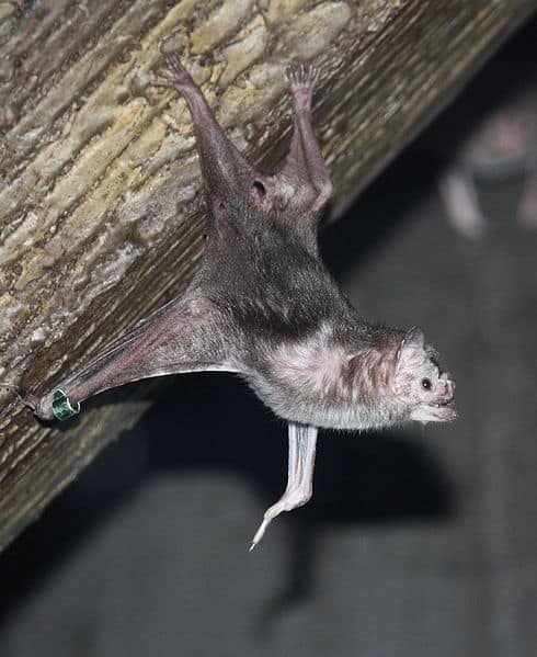
Ocelot (Leopardus pardalis) Margay (Leopardus wiedii) Tayra (Eira barbara) White-naped jay (Cyanocorax cyanopogon) Common vampire bat (Desmodus rotundus)

State & Provincial Parks

Coco State Park

~1,570 ha

Major urban-proximate mangrove and riparian refuge in Fortaleza; important for waterbirds, estuarine fish nurseries, and maintaining coastal ecological connectivity in a heavily developed corridor.

Rufous crab-hawk (Buteogallus aequinoctialis) Snowy egret (Egretta thula) Black-crowned night-heron (Nycticorax nycticorax) Capybara (Hydrochoerus hydrochaeris) Green iguana (Iguana iguana)

Parque Estadual Marinho da Pedra da Risca do Meio

~3,300 ha

Nearshore marine park protecting reef habitats used by reef fish and invertebrates; valued for underwater wildlife viewing and as a local refuge from coastal fishing pressure.

Hawksbill sea turtle (Eretmochelys imbricata) Green sea turtle (Chelonia mydas) French angelfish (Pomacanthus paru) Sergeant major (Abudefduf saxatilis) Spiny lobster (Panulirus spp.)

Pedra da Risca do Meio State Marine Park

~3,300 ha

Nearshore marine park protecting reef habitats used by reef fish and invertebrates; valued for underwater wildlife viewing and as a local refuge from coastal fishing pressure.

Hawksbill sea turtle (Eretmochelys imbricata) Green sea turtle (Chelonia mydas) French angelfish (Pomacanthus paru) Sergeant major (Abudefduf saxatilis) Spiny lobster (Panulirus spp.)

Quixada Monoliths State Natural Monument

~16,600 ha (approx.)

Striking inselberg landscape with rocky outcrops and seasonally dry Caatinga vegetation; notable for raptors, rock-dwelling reptiles, and dryland-adapted mammals in a scenic, relatively low-fragmentation setting.

Red-legged seriema (Cariama cristata) Roadside hawk (Rupornis magnirostris) Rock cavy (Kerodon rupestris) Crab-eating fox (Cerdocyon thous) Black-and-white tegu (Salvator merianae)

Wildlife Refuges

Pedra da Andorinha Wildlife Refuge

~600 ha

A federal strictly protected area in Ceará created as a Wildlife Refuge category conservation unit, protecting Caatinga habitats (including rocky outcrops) and associated wildlife with restricted human use focused on conserving fauna and flora.

Araripe-Apodi National Forest

~39,000 ha

Large federal forest on the Araripe Plateau with springs, forest mosaics, and strong bird endemism; a key landscape for conserving humid enclaves and water sources in a semi-arid region.

Araripe manakin (Antilophia bokermanni) Ocelot (Leopardus pardalis) Tayra (Eira barbara) Blue-fronted amazon (Amazona aestiva) Collared peccary (Pecari tajacu)

Batoque Extractive Reserve

~600 ha (approx.)

Community-managed coastal reserve protecting dunes, lagoons, and coastal scrub; supports migratory and coastal birds and helps limit habitat loss from shoreline development.

Wilson's plover (Charadrius wilsonia) Royal tern (Thalasseus maximus) Neotropical otter (Lontra longicaudis) Green sea turtle (Chelonia mydas) Rufous crab-hawk (Buteogallus aequinoctialis)

Parnaiba Delta Environmental Protection Area (Ceara portion)

~313,800 ha (entire protected area; only a small portion lies in Ceara)

Vast multi-state coastal and mangrove-delta protected landscape; the Ceara portion contributes critical mangroves, tidal channels, and sand islands for fish nurseries and large concentrations of waterbirds.

Scarlet ibis (Eudocimus ruber) Roseate spoonbill (Platalea ajaja) Rufous crab-hawk (Buteogallus aequinoctialis) West Indian manatee (Trichechus manatus) Neotropical cormorant (Nannopterum brasilianum)

Wilderness Areas

  • Remote interior backcountry blocks in the Inhamuns region (low-density, road-sparse landscapes around and between protected areas)
  • Araripe Plateau uplands and spring-fed forest enclaves (outside core units), forming one of the largest remaining semi-connected highland habitats in southern Ceara
  • Ibiapaba Range escarpments and forest patches surrounding Ubajara National Park, including less-accessed ravines and cave-bearing limestone areas
  • Coastal dune fields and interdunal lagoons between Jericoacoara and Camocim (pockets of low-road access where dunes and seasonal wetlands remain dynamic)
  • Mangrove and estuary mosaics along the lower Jaguaribe River and associated coastal wetlands, with relatively undeveloped stretches compared to urbanized sectors
Animals

Wildlife

Ceará's wildlife shows a big change from the semi-arid Caatinga—thorn scrub, dry forests, rocky outcrops, and river valleys—to a narrow, diverse coast with dunes, lagoons, estuaries, mangroves, and nearshore reefs. The interior has mammals, reptiles, and birds that tolerate drought, many Caatinga specialists. The coast has waterbirds, migratory shorebirds, sea turtles, and estuarine fish. The Chapada do Araripe in southern Ceará adds humid forest patches and springs that host birds found only there, making it an important area for species protection.
~140-170 species (terrestrial + bats; exact totals vary by survey coverage) Mammals
~480-560 species (high due to coastal wetlands + Caatinga + Araripe forests) Birds
~140-180 species (lizards and snakes especially diverse in Caatinga and dunes) Reptiles
~60-90 species (concentrated around seasonal wetlands, springs, and upland humid enclaves) Amphibians
~250-400+ species (freshwater reservoir/river fauna plus very diverse estuarine and coastal marine fishes) Fish
Examples

Iconic Species

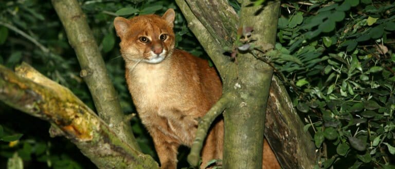
Jaguar
Jaguar A symbol of intact ecosystems; now rare in Ceará, but its presence (or historical range) defines conservation narratives in the Caatinga and remaining forested refuges.
Puma (Cougar) The state's most widespread large cat, occurring in Caatinga mosaics and rugged uplands; a key apex predator visitors hope to track by sign.
Brazilian Three-banded Armadillo A Caatinga flagship mammal known for rolling into a ball; emblematic of northeastern Brazil's dryland biodiversity.
Giant Anteater A charismatic insect specialist of open habitats; where it persists, it highlights larger, better-connected Caatinga landscapes.
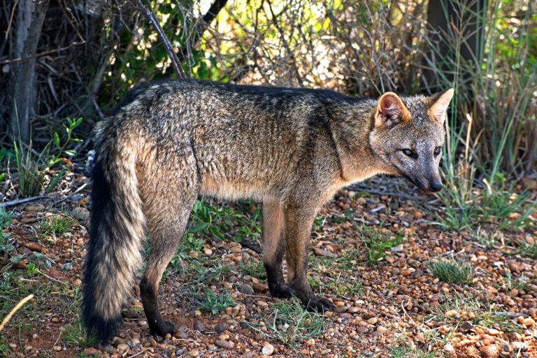
Crab-eating Fox
Crab-eating Fox A common, adaptable canid often seen at dusk along edges of scrub, farmland, and protected areas-one of the most frequently observed mid-sized mammals.
Red-legged Seriema A tall, vocal ground bird of open scrub and grasslands; its calls and stalking behavior are a classic Sertão wildlife experience.
Araripe Manakin One of Brazil's most celebrated endemics, restricted to humid spring-fed forest on the Chapada do Araripe; a prime target for birdwatchers.
Hawksbill Sea Turtle A globally threatened sea turtle that uses parts of Ceará's coast for nesting and foraging; conservation patrols make it a flagship coastal species.
West Indian Manatee A rare marine herbivore tied to calm coastal waters, estuaries, and seagrass/mangrove systems; sightings are a highlight where protected.

Endemic & Rare Species

Araripe Manakin

Antilophia bokermanni

Endangered (IUCN) / extremely range-restricted endemic

Endemic to the Chapada do Araripe (notably on the Ceará side) and dependent on perennial springs and humid forest strips-highly vulnerable to water extraction, habitat degradation, and drought intensification.

Araripe Antwren

Formicivora grantsaui

Critically Endangered (often treated as CR due to tiny range and ongoing habitat loss)

A very localized Araripe endemic associated with dry forest/scrub mosaics; its limited distribution makes Ceará (Araripe) central to the species' global survival.

Brazilian Three-banded Armadillo

Tolypeutes tricinctus

Vulnerable (IUCN) / Caatinga endemic

A northeastern Brazil endemic closely tied to Caatinga habitats; threatened by hunting and habitat conversion, it represents the uniqueness of Ceará's drylands.

West Indian Manatee

Trichechus manatus

Vulnerable (IUCN) / regionally rare

Historically depleted along Brazil's northeast coast; small numbers use suitable estuaries and nearshore habitats, making Ceará important for coastal recovery efforts.

Hawksbill Sea Turtle

Eretmochelys imbricata

Critically Endangered (IUCN)

Nesting and nearshore foraging along parts of northeastern Brazil make Ceará's beaches and reefs relevant for a species facing bycatch, illegal take, and habitat loss.

Notable Populations

  • Chapada do Araripe: globally significant, highly concentrated endemism for birds (notably Araripe Manakin and Araripe Antwren) tied to spring-fed forest refuges.
  • Coastal Ceará: regionally important nesting/foraging areas for threatened sea turtles (especially Hawksbill and also Green Turtle in parts of the northeast).
  • Estuaries, mangroves, and lagoons: nationally important feeding and stopover habitat for migratory shorebirds and large mixed waterbird assemblages (seasonal peaks).
  • Caatinga protected areas and larger intact shrubland blocks: regionally important strongholds for Caatinga specialists (including armadillos, seriemas, and a diverse reptile fauna).

Recent Changes

  • Increasing pressure on Araripe spring systems (water extraction, land-use change) has intensified conservation concern for Araripe endemics; some sites report habitat degradation and heightened drought sensitivity.
  • Sea turtle conservation actions (nest monitoring, protection, community programs) have improved hatchling output in monitored stretches, though bycatch and coastal development remain chronic threats.
  • Manatee rehabilitation and managed releases have occurred in northeastern Brazil; coastal monitoring has increased the likelihood of occasional sightings and localized recovery where threats are controlled.
  • Expansion of wind-energy infrastructure along the coast has introduced new collision/disturbance risks for birds and bats in some areas, prompting stronger monitoring/mitigation discussions.
  • Ongoing Caatinga conversion (charcoal/wood extraction, grazing, agriculture) continues to fragment habitat, contributing to local declines of larger mammals and hunting-sensitive species.
  • Freshwater fish communities in reservoirs and rivers have been altered by damming and the spread of non-native fishes (e.g., tilapias), which can reduce native diversity and change food webs.
Visit

Wildlife Viewing

Ceará has two wildlife areas: a semi-arid interior with dry thorn scrub and rocky outcrops for dryland birds, reptiles, and mammals, and a greener Atlantic coast with dunes, freshwater lagoons, mangroves, and estuaries that attract shorebirds and herons. Best viewing is early or late inland and at low tides or calm mornings on the coast.

Best Seasons

Rainy season (roughly Feb-May; varies by year)

Dry thorn scrub responds quickly with greener vegetation, flowers, and insects, often increasing bird activity; water-dependent species can be easier to find around temporary pools. Expect humid heat and occasional heavy downpours; some dirt roads in the interior can become slow or muddy.

Early dry season (Jun-Aug)

Comfortable temperatures and generally clearer skies. Wetlands and lagoons still hold water, concentrating herons, egrets, ibises, and migratory shorebirds in coastal zones. Great for mixed itineraries (coast plus interior) with good road reliability.

Peak dry season (Sep-Nov)

Best for locating wildlife in the semi-arid interior as animals concentrate near remaining water sources; excellent visibility and fewer mosquitoes. It can be very hot and dry-plan dawn and late-afternoon outings and carry ample water.

Austral summer / holiday season (Dec-Jan)

Coastal conditions often favor calm-morning boat trips in bays and estuaries and lagoon outings, plus strong chances for impressive dune-and-lagoon landscapes. Heat is high; popular beaches are busy-choose quieter coastal villages and go birding at sunrise for the best wildlife activity.

Top Wildlife Experiences

  • Birding and sunrise wildlife walk in Jericoacoara National Park: scan dune-lagoon edges for herons, egrets, sandpipers, and other shorebirds; combine with a quiet early visit to Paradise Lagoon / Blue Lagoon to avoid crowds.
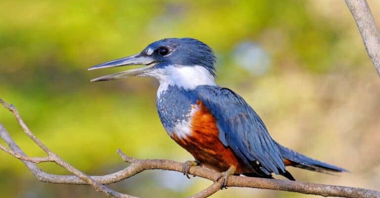
  • Mangrove and estuary boat trip in the Jaguaribe River region (around Aracati/Fortim and the Canoa Quebrada area): look for mangrove specialists, kingfishers, herons, and crabs; time the outing for mid-to-low tide to see the most feeding activity.
  • Coastal shorebird day around Icapui and the far-east Ceara coastline: explore tidal flats, beaches, and estuaries for migrating and resident shorebirds; best at low tide with a scope and a local guide who knows roost sites.
  • Dry thorn-scrub wildlife drive and night spotlighting in the semi-arid interior (around Quixada/Quixeramobim): search rocky inselbergs and scrub for regionally adapted birds by day; after dark, look for nocturnal mammals, owls, and reptiles (ethical spotlighting with minimal disturbance).
  • Hike the Baturite Range area (from Guaramiranga/Pacoti) for a 'green island' effect: cooler, more humid forest patches can add different bird communities compared to the lowlands; focus on mixed-species flocks along forest edges and shade coffee/agroforestry landscapes.
  • Boat or kayak wildlife outing in coastal lagoons near Camocim/Barroquinha (toward the Ceara-Piaui border): calm waters at dawn are ideal for waterbirds; combine with dune viewpoints for raptor spotting.
  • Rocky-coast and tidepool naturalist walk (select headlands and reefy stretches along the coast, conditions permitting): look for intertidal life at spring low tides; pair with seabird scanning from vantage points in early morning.

Wildlife Watching Types

Birding (dry thorn-scrub species, coastal shorebirds, mangrove birds, raptors) Mangrove/estuary wildlife watching (boat or canoe/kayak) Shorebird and seabird scanning from beaches, headlands, and tidal flats Reptile and amphibian watching (seasonal; strongest after rains and around water) Nocturnal wildlife walks/spotlighting in the semi-arid interior (owls, nightjars, small mammals; with care and permits) Lagoon and dune ecosystem tours (freshwater lagoons, dune-edge fauna) Intertidal/tidepool observation (timed to low tides) Occasional offshore marine megafauna sightings during boat outings (opportunistic rather than guaranteed)

Guided Options

  • ICMBio/park-supported guiding and local accredited guides in Jericoacoara National Park (interpretive walks, birding at lagoons/dunes; check current access rules and required guide areas).
  • Community-based mangrove/river tours led by local boatmen in the Jaguaribe estuary zone (Aracati/Fortim): practical for tides, bird roosts, and safe navigation.
  • Local birding guides based in Fortaleza and the coast (custom day trips to mangroves, beaches, and lagoons; often provide optics and transport).
  • Semi-arid interior naturalist drivers/guides (Quixada/Quixeramobim region) for dry thorn-scrub birding plus ethical night drives on private lands where permitted.
  • Baturite Range/Guaramiranga region guides (forest-edge bird walks and conservation-minded visits to private reserves and shade-coffee landscapes).
  • University/NGO-led environmental education programs and occasional public bird walks in Fortaleza and nearby protected areas (availability varies; look for scheduled outings through local environmental groups and municipal programs).
Habitats

Ecosystems

Ceara has a strong wet to dry change: a mostly semi-arid interior (backcountry) of Caatinga dry scrub and seasonally dry forest, and wetter coastal plains with small humid forests on high massifs (Baturite Mountains, Ibiapaba Plateau, Araripe Plateau). It also has dry shrublands, seasonal rivers, and an Atlantic coast with dunes, lagoons, estuaries, and mangroves.

Biomes

Tropical Dry Forest

The Caatinga matrix-seasonally dry tropical vegetation ranging from thorny scrub to deciduous dry forest, adapted to drought, high temperatures, and irregular rainfall; many waterways are seasonal or intermittent.

Dominant across most of the interior (majority of the state), especially in the central and western backcountry.

Tropical Rainforest

Humid forest enclaves (montane humid forest enclaves) on windward slopes and plateaus where orographic rainfall maintains evergreen or semi-evergreen Atlantic Forest-like vegetation; high local endemism and refuges for moisture-dependent species.

Small, fragmented pockets at higher elevations (notably the Baturite Mountains, parts of the Ibiapaba Plateau, and the Araripe Plateau).

Savanna

Open, grassy-woody mosaics and Cerrado-like enclaves on plateaus and sandy/poor soils, sometimes grading into Caatinga or coastal restinga woodlands.

Localized patches (not continuous), mainly on uplands/plateaus and some sandy inland areas.

Freshwater

Rivers, reservoirs, and temporary lagoons and streams that expand in the wet season and contract in the dry season; critical for water security and aquatic and shorebird habitats.

Widespread but highly seasonal; concentrated along major basins (for example, the Jaguaribe) and around large reservoirs.

Wetland

Coastal and riverine wetlands including floodplains, marshy lagoons, and mangrove-associated backwaters; productivity supports fish nurseries and waterbirds.

Patchy, primarily along the coast and lower river valleys; expands after heavy rains.

Marine

Tropical Atlantic coastal waters with sandy and rocky nearshore habitats, reefs/reef-like hardgrounds in places, and productive estuarine plumes near river mouths.

Along the entire Atlantic coastline; strongest ecological gradients around estuaries and headlands.

Habitats

Shrubland

Caatinga thorn scrub with cacti, bromeliads, and deciduous shrubs; strong seasonality with leaf-drop in the dry season.

Woodland

Denser Caatinga arboreal patches and dry woodlands (including carnauba palm-dominated areas in suitable lowlands), often interspersed with open scrub.

Deciduous Forest

Seasonally dry deciduous forest formations within the Caatinga domain, especially where soils/moisture allow taller canopies.

Forest

Mixed dry-to-moist forest mosaics on slopes and protected valleys, including transitional zones between Caatinga and humid enclaves.

Rainforest

Montane humid forests (humid forest enclaves) with higher canopy cover, epiphytes, and cooler and moister microclimates (for example, the Baturite Mountains).

Savanna

Open vegetation with scattered trees and a grassy layer in localized Cerrado-like enclaves and ecotones.

Grassland

Seasonal grasslands and open herbaceous areas on plains, around reservoirs, and within coastal dune-lagoon systems.

Desert

No true desert, but extensive semi-arid landscapes with sparse vegetation during peak drought can appear desert-like in parts of the Sertão.

Mountain

Uplands and massifs (e.g., Baturité, Ibiapaba, Araripe) creating sharp climatic gradients and habitat refuges.

Cliff/Rocky Outcrop

Escarpments and rocky outcrops on plateau edges (notably Araripe/Ibiapaba) providing nesting/roosting sites and specialized flora.

Cave

Limestone cave systems such as those in Ubajara National Park, supporting bats and cave-adapted invertebrates.

River/Stream

Intermittent and perennial stretches (e.g., Jaguaribe basin) with riparian corridors, sandbars, and seasonal flood dynamics.

Lake

Coastal lagoons and inland reservoirs (açudes) that function as key waterbird habitat and local fisheries resources.

Wetland

Marshy lagoon margins, floodplains, and lowland wet areas-highly variable year to year with rainfall.

Marsh

Fresh to brackish marshes along lagoon edges and lower river plains, often dominated by emergent vegetation.

Mangrove

Mangrove forests in estuaries (e.g., along the Ceará coast) serving as nurseries for crustaceans/fish and buffers against erosion.

Estuary

River-mouth mixing zones with strong salinity gradients, mudflats, and high productivity supporting fisheries and shorebirds.

Coastal

Coastal plains with dunes, interdune wetlands, restinga vegetation, and rapidly shifting sandy substrates.

Rocky Shore

Localized rocky headlands and abrasion platforms that add habitat complexity compared to predominantly sandy coasts.

Open Ocean

Nearshore pelagic waters used by migratory species and supporting regional fisheries beyond the immediate surf zone.

Seabed/Benthic

Mostly sandy/muddy bottoms near the coast with patches of hard substrate in some areas; influenced by river plumes and coastal currents.

Urban

Dense urban/coastal development (e.g., Fortaleza metro area) driving habitat conversion and fragmentation, especially along shorelines.

Agricultural/Farmland

Mixed farming and grazing across the Sertão plus irrigated agriculture in wetter pockets/valleys; major driver of Caatinga conversion.

Ecoregions

Caatinga (WWF NT1304) Atlantic Coast restingas (WWF NT0210) Northeastern Brazil mangroves (WWF NT1402) Pernambuco interior forests (WWF NT0103) Northeastern Brazil (MEOW marine ecoregion)
Protection

Conservation

Primary Threats

  • In Ceará's semi-arid interior, dry thorn scrub and seasonally dry woodland are turned into pasture, small farms, and fodder, leaving small, damaged patches. Along the coast, dunes, sand-plain scrub, mangroves, and coastal lagoons are lost or changed by housing, roads, and tourism, reducing nesting and feeding areas for coastal wildlife.
  • Rising temperatures and more irregular rain make multi-year droughts worse in northeast Brazil's semi-arid zone, stressing plants, degrading land, and forcing wildlife toward scarce water and moist upland refuges. Sea-level rise and stronger storms threaten mangroves, estuaries, and sea turtle nesting beaches.
  • Raw sewage and trash from Fortaleza and other cities pollute rivers, estuaries, lagoons, beaches, and nearshore waters. Plastics and old fishing gear hurt coasts. Runoff from irrigated valleys (for example Jaguaribe) with fertilizers and pesticides damages aquatic habitats, fish nurseries, and downstream estuaries and mangroves.
  • Introduced tilapia and other stocked fishes dominate many reservoirs and modified river reaches, displacing native fish assemblages. In the semi-arid interior, invasive mesquite and other non-native plants can simplify native vegetation, while free-ranging dogs and cats near settlements increase predation pressure on small vertebrates and nesting birds.
  • High densities of free-ranging domestic animals near protected areas increase risks of pathogen spillover (for example, dog-borne diseases affecting wild carnivores) and add chronic pressure through harassment and predation; drought can amplify disease and transmission risk by concentrating wildlife and livestock at limited water sources.
  • Subsistence and opportunistic hunting persists in parts of the semi-arid interior (including armadillos, small mammals, and birds), and can increase during drought-related economic stress. Hunting pressure is especially damaging in fragmented habitats and isolated forest refuges where populations are small.
  • Illegal capture and trade of native songbirds and parrots persists in northeast Brazil, including Ceará, enabled by road access between interior towns and coastal markets; sustained removal can depress local populations and disrupt ecological functions such as seed dispersal.
  • Heavy fishing pressure in coastal and estuarine waters (including lobster fisheries and reef-associated fishes) reduces biomass and alters food webs; bycatch can affect sea turtles. Long-lived reef species remain vulnerable where enforcement is weak and habitats are degraded.
  • Intense coastal tourism and recreation (off-road vehicles on dunes, nighttime beach use, uncontrolled access) can disturb nesting turtles and shorebirds and destabilize dunes. Urban noise and light near beaches and estuaries can alter wildlife movement and behavior.
  • Large reservoirs and river regulation (notably in the Jaguaribe basin) fragment aquatic connectivity, alter seasonal flow patterns, and change sediment delivery to estuaries. Coastal wind farms and associated transmission corridors can fragment dune and sand-plain habitats and pose collision risks for birds and bats if poorly sited.
  • Water storage, channel modifications, and inter-basin transfers designed for drought security can reduce natural flow seasonality important for wetlands and estuarine productivity. Frequent or uncontrolled burning used for land management can simplify vegetation structure and hinder regeneration in dry ecosystems.
  • Expansion and intensification of irrigated agriculture in river valleys increases water withdrawals, promotes riparian clearing, and elevates agrochemical loads. Coastal shrimp farming can drive mangrove clearing and create nutrient-rich effluents that degrade estuarine nursery habitats.
  • Growth of Fortaleza and coastal towns increases land take in dunes and sand-plain scrub, raises sewage and stormwater pollution loads, and hardens shorelines. Urban expansion into floodplains reduces riparian corridors that could function as movement routes and buffers in a dry region.
  • Chronic extraction of fuelwood and charcoal for households and small industries is a major driver of degradation in the semi-arid dry-vegetation zone, reducing mature woody cover, hollow-bearing trees, and structural complexity needed by birds and mammals.
  • Sand extraction in coastal dune fields and quarrying for aggregates and stone inland can remove or destabilize habitats, increase erosion and sedimentation, and open access roads that can stimulate further clearing and hunting pressure.
Fun Facts

Did You Know?

Ceará has a "rainforest island" inside a semi-arid state: along the slopes of the Chapada do Araripe, spring-fed humid forest enclaves persist next to dry Caatinga-exactly the odd ecological contrast that allows the Araripe manakin to exist there at all.

Some Caatinga frogs in Ceará survive the long dry season by essentially disappearing underground: the Caatinga frog (*Pleurodema diplolister*) can estivate for months in burrows, reducing activity until rains return and temporary pools form.

The cactus parakeet (*Eupsittula cactorum*), recorded in Ceará's Caatinga, often nests in columnar cacti such as *Cereus jamacaru*: the spines act like a living barbed-wire fence around the nest cavity.

In Ceará's estuaries (e.g., Cocó, Pacoti, Jaguaribe), mangrove trees actively manage salt: black mangrove (*Avicennia germinans*) can excrete salt through its leaves, sometimes leaving visible salty crystals.

Ceará's dunes and coastal lagoons create "moving habitat": wind-driven sand migration can rapidly reshape shorelines, yet wildlife (from dune insects to shorebirds using the beach zone) tracks these shifts-making the landscape itself a constantly changing ecological stage.

A single cashew tree in Pacajus-often promoted as the world's largest cashew tree-spreads by natural layering to cover about 8,400 m² (roughly the area of a football pitch), creating an exceptionally large canopy from a single individual.

The Araripe manakin (*Antilophia bokermanni*) is a Ceará specialty with an extraordinarily tiny global range-restricted to humid forest fed by springs on the Chapada do Araripe-placing it among the most range-restricted bird species on Earth.

Ceará's Araripe Basin (Crato and Santana formations, ~110 million years old) is internationally regarded as a world-class fossil "Lagerstätte," famous for exceptional 3D preservation of Cretaceous life (notably pterosaurs, fish, and insects).

In Ceará's Caatinga, you can find the Brazilian three-banded armadillo (*Tolypeutes tricinctus*), one of only two armadillo species that can roll completely into a tight ball-an extreme defensive adaptation.

Thank you for reading! Have some feedback for us?