N S W E
Wildlife Expeditions

Wildlife of
Amapá

Amapá is where intact Amazon rainforest meets the Atlantic-home to vast protected areas, wildlife-rich estuaries, and a rare mix of rainforest and coastal species.
37 Species
142,814.6 km² Land Area
Overview

About Amapá

Amapá's wildlife is shaped by big, connected tracts of lowland Amazon rainforest. Rivers and seasonally flooded forests link the landscape and support many mammals, birds, and amphibians. Large protected areas and Indigenous territories help keep key processes going, such as long trips by large roaming predators and regrowth of floodplain forests. Main habitats include upland (non-flooded) rainforest, seasonally flooded floodplain forests (whitewater and blackwater), and the Amazon River estuary with mangroves and coastal wetlands near Macapá. The estuary and coast are important nurseries for fish and crustaceans and feeding grounds for waterbirds. Interior forests hold classic Amazon large animals (megafauna) and many kinds of primates. Amapá’s river-to-sea link is rare, with strong influence from the Guiana Shield and continuity into French Guiana.

Physical Features

Geography

Amapá's wildlife shows a strong change from Amazonian lowland rainforest and wide river floodplains to coastal mangroves and Atlantic mudflats, while isolated Guiana Shield uplands add higher, drier forests inland. Large protected areas keep connected forest corridors, and the Amazon River estuary and coastal wetlands attract many water and migrating animals near Macapá and the coast.

142,814.6 km² Land Area
18th largest state in Brazil (smallest in the North Region) Size Rank
Brazil Country
State Type
Elevation Range

Sea level to ~823 m (interior Guiana Shield uplands in the Tumucumaque region)

Coastline

Atlantic Ocean coastline (Amazon-influenced), dominated by mangroves, tidal channels, coastal mudflats, and beach/coastal sandy scrub habitats (around ~578 km of shoreline).

Key Landscapes

Lowland Amazon tropical rainforest (non-flooded upland forest) covering much of the interior Extensive protected-area mosaics (e.g., Tumucumaque Mountains National Park region) supporting large, continuous habitat for wide-ranging mammals and birds Guiana Shield uplands and interior ranges (Tumucumaque/related highlands) with better-drained forests and localized endemism Major river systems and corridors: Amazon River margin/estuary influence; Oiapoque River (border with French Guiana); Jari River (border with Pará); Araguari River and associated wetlands Seasonally flooded forests and floodplains (whitewater-flooded and blackwater-flooded forests) and freshwater wetlands important for fish, caimans, river dolphins, and waterbirds Amazon River estuary and coastal lagoon/river-mouth complexes around Macapá with strong freshwater-saltwater mixing affecting fisheries and coastal biodiversity patterns (including the tidal bore area on the Araguari system historically noted for strong tides and flows in the region's coastal rivers and estuaries).
Parks & Reserves

Protected Areas

Amapá has one of Brazil's largest, linked protected-area networks, with big federal parks, reserves, and state and community areas. It protects much of the Guiana Shield forests (high wilderness, few roads) and key coastal ecosystems—mangroves, mudflats, flooded forests, and river-mouths near the Amazon estuary and Atlantic coast—forming a corridor for jaguar, harpy eagle, coastal birds, and aquatic life.

Protected Coverage

≈70% of Amapá is under some form of protection when combining conservation units and Indigenous lands (with conservation units alone often cited at roughly ~60%+).

National Parks & Preserves

Tumucumaque Mountains National Park

≈38,000 km² (≈3.8 million ha)

One of the world's largest tropical forest national parks, protecting vast roadless rainforest and headwaters on the Guiana Shield; exceptional for large-mammal conservation and intact predator-prey systems.

Jaguar (Panthera onca) Harpy eagle (Harpia harpyja) Giant otter (Pteronura brasiliensis) Lowland tapir (Tapirus terrestris) White-lipped peccary (Tayassu pecari)

Cape Orange National Park

≈6,500 km² (≈650,000 ha)

A flagship protected area for Amazon-Atlantic coastal interfaces: extensive mangroves, flooded plains, beaches, and estuaries supporting major birdlife concentrations and coastal aquatic fauna.

Scarlet ibis (Eudocimus ruber) Green sea turtle (Chelonia mydas) West Indian manatee (Trichechus manatus) Jabiru (Jabiru mycteria) Jaguar (Panthera onca)

State & Provincial Parks

Iratapuru River Sustainable Development Reserve

806,184 ha (≈8,062 km²)

State-level sustainable-use protected area in Amapá created to conserve forest and river ecosystems while supporting traditional communities; part of Amapá's large protected-area mosaic.

Amapá State Forest

2,369,400 ha (≈23,694 km²)

State-level sustainable-use protected area (state forest) managed for conservation and regulated use; helps maintain large, continuous Amazon forest habitat in Amapá.

Wildlife Refuges

Cajari River Extractive Reserve

501,771 ha (≈5,018 km²)

Federal extractive reserve conserving extensive floodplain and upland rainforest while supporting traditional communities; important for maintaining large contiguous habitat and riverine wildlife.

Jaguar (Panthera onca) Giant otter (Pteronura brasiliensis) Lowland tapir (Tapirus terrestris) Black spider monkey (Ateles paniscus) Harpy eagle (Harpia harpyja)

Amapá Extractive Reserve

877,068 ha (≈8,771 km²)

Coastal/near-coastal extractive reserve protecting mangroves, estuaries, and coastal forests-key nursery habitats for fish and crustaceans and major feeding/roosting areas for waterbirds.

Scarlet ibis (Eudocimus ruber) Roseate spoonbill (Platalea ajaja) West Indian manatee (Trichechus manatus) Green sea turtle (Chelonia mydas) Black caiman (Melanosuchus niger)

Bailique Marine Extractive Reserve

133,470 ha (≈1,335 km²)

Estuarine/marine protected area in the Amazon River mouth island system; important for mangrove-dependent food webs, coastal birds, and sustaining fisheries with conservation outcomes.

Scarlet ibis (Eudocimus ruber) West Indian manatee (Trichechus manatus) Green sea turtle (Chelonia mydas) Tucuxi/Guiana dolphin (Sotalia guianensis) Black skimmer (Rynchops niger)

Wilderness Areas

  • Tumucumaque Mountains National Park (Parque Nacional Montanhas do Tumucumaque)
  • Cabo Orange National Park (Parque Nacional do Cabo Orange)
  • Lago Piratuba Biological Reserve (Reserva Biológica do Lago Piratuba)
  • Amapá National Forest (Floresta Nacional do Amapá)
  • Cajari River Extractive Reserve (Reserva Extrativista do Rio Cajari)
Animals

Wildlife

Amapá sits where the Guiana Shield rainforest meets the Amazon River estuary and an Atlantic coast dominated by vast mangroves and flooded plains. This mix of largely intact tropical forest (including some of Brazil's largest protected areas) plus estuarine/coastal ecosystems produces exceptionally high wildlife diversity-from forest predators like jaguars and harpy eagles to river specialists such as giant otters and river dolphins, and coastal icons like scarlet ibises and sea turtles.

~180-220 species (high primate, cat, and aquatic-mammal diversity) Mammals
~550-700 species (Guianan/Amazon forest birds plus large coastal waterbird assemblages) Birds
~140-200 species (crocodilians, large snakes, river and coastal turtles) Reptiles
~120-180 species (especially diverse forest frogs in intact interior habitats) Amphibians
600+ species likely statewide (very high freshwater diversity across major river basins and floodplains) Fish
Examples

Iconic Species

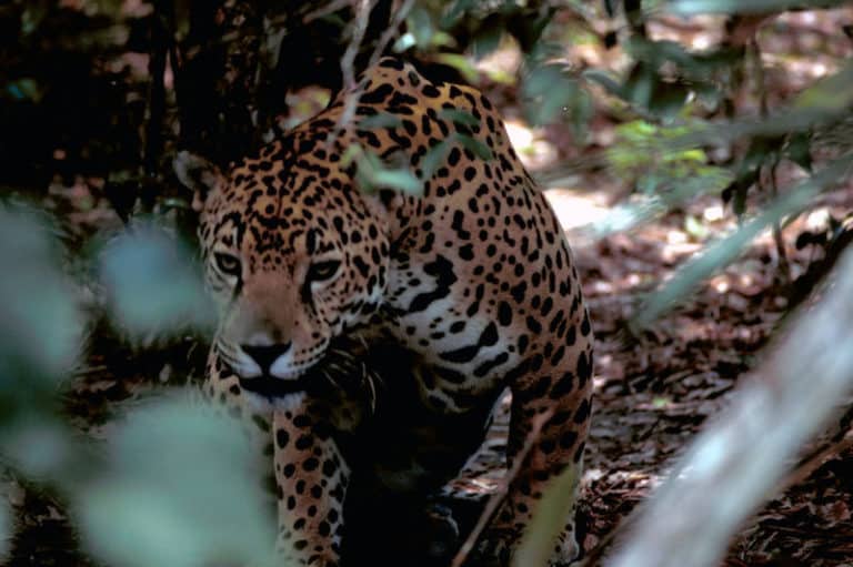
Jaguar
Jaguar Amapá's extensive, connected protected forests support one of the best remaining landscapes in Brazil for seeing signs of jaguars (tracks, kills) and for sustaining viable populations.
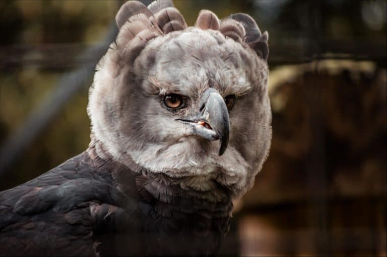
Harpy Eagle
Harpy Eagle A flagship canopy predator of intact rainforest; Amapá's large continuous forests increase the chance of encountering this species compared with more fragmented parts of the Amazon.
Giant River Otter A charismatic, social top predator of clear rivers, oxbows, and lakes-often a highlight in well-protected waterways and remote interior reserves.
Amazon River Dolphin
Amazon River Dolphin Commonly encountered in larger rivers and floodplain waters; an emblematic Amazon species for visitors traveling by boat in Amapá's river systems.
Amazonian Manatee A quiet, vegetation-eating aquatic mammal associated with floodplains and calm waters; Amapá's protected wetlands and reserves are important refuges where it still persists.
Scarlet Ibis A defining coastal/mangrove experience: striking red flocks use estuaries and mudflats, especially around protected coastal habitats.
Black Caiman A top predator of Amazon wetlands and rivers; historically overhunted, it remains a powerful symbol of intact aquatic food webs where protections are effective.
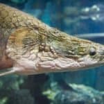
Arapaima
Arapaima One of the world's largest freshwater fishes; culturally and economically important, and a sought-after wildlife sighting in floodplain lakes where populations are managed.

Endemic & Rare Species

Amapá Antbird

Myrmotherula amapaensis

Range-restricted Amazonian endemic (limited distribution; conservation depends on maintaining intact lowland forest)

A signature bird for the state's eastern Amazon/Guiana Shield interface; valued by birders seeking localized species in Amapá's forests.

Giant River Otter

Pteronura brasiliensis

Endangered (IUCN)

Still present in remote, well-protected river networks; Amapá's large reserves are important for maintaining viable groups.

Red-faced Spider Monkey

Ateles paniscus

Vulnerable (IUCN)

A large, canopy-dwelling primate of the Guiana Shield and northeastern Amazon forests; sensitive to hunting and habitat disturbance, making large connected protected areas in Amapá important for its long-term persistence.

Guianan Red Howler Monkey

Alouatta macconnelli

Least Concern (IUCN)

A loud, conspicuous howler monkey widespread across the Guiana Shield and adjacent northern Amazon forests, including Amapá; locally impacted by hunting and habitat disturbance despite a relatively broad overall range.

West Indian Manatee

Trichechus manatus

Vulnerable (IUCN)

Occurs in coastal/estuarine waters; Amapá's mangroves and estuaries can serve as key habitat in northern Brazil where the species is generally scarce.

Leatherback Sea Turtle

Dermochelys coriacea

Vulnerable (IUCN; many Atlantic nesting populations are highly threatened)

Amapá's dynamic Amazon-mouth coastline and protected beaches/nearshore waters are part of the broader north-coast sea turtle conservation landscape, where nesting/foraging is sensitive to fisheries bycatch and coastal change.

Notable Populations

  • One of the largest continuous blocks of protected tropical forest in Brazil (including the Tumucumaque Mountains region), supporting intact predator-prey systems (jaguar, harpy eagle, large primates).
  • Nationally significant mangrove and estuarine bird concentrations along the Amazon River mouth/Atlantic coast, including large scarlet ibis roosting/foraging areas.
  • Important wetland and floodplain habitats (e.g., large protected lakes and seasonally flooded areas) that function as refuges for aquatic mammals (manatees, river dolphins) and wetland reptiles (black caiman).
  • High freshwater fish diversity and key fisheries species (notably arapaima in managed systems), tied to extensive river-floodplain connectivity.

Recent Changes

  • Localized declines and disturbance risks in some river systems linked to illegal gold mining and associated mercury contamination, affecting fish, river dolphins, and human communities reliant on waterways.
  • In some managed floodplain/lake areas, community-based fisheries rules and enforcement have supported recoveries or stabilization of high-value species such as arapaima and some heavily harvested aquatic fauna.
  • Shifting sediments, erosion, and changing shoreline configuration near the Amazon River mouth have altered some coastal habitats (mudflats, beaches, mangroves), with knock-on effects for waterbirds and sea turtle nesting suitability.
  • Ongoing infrastructure expansion and increased access along road corridors have increased hunting/fragmentation pressure in specific zones, while large protected areas continue to provide strongholds where enforcement is effective.
Visit

Wildlife Viewing

Amapá is a largely intact Amazon state with rainforest (Tumucumaque Mountains), the Amazon estuary, mangroves, coastal savannas, and beaches near Macapá. Wildlife includes primates, sloths, tapirs, macaws, toucans, cotingas, raptors, river dolphins, caimans, giant otter, and seasonal sea turtle nesting. Best trips combine days around Macapá with an expedition river journey.

Best Seasons

Dry season (roughly Aug-Nov)

Generally easier logistics on trails and riverbanks; clearer access to forest edges and upland areas; strong bird activity at fruiting trees and along waterways; good for multi-day expeditions into remote protected areas with fewer weather delays. Water levels drop, concentrating wildlife along rivers and lakes-good for spotting tracks, primates, and river birds.

Early wet / "shoulder" season (Dec-Feb)

Lush forest and high vocal activity from birds and frogs; rivers begin rising-better boat access into flooded forests in some areas; excellent time for photography of vibrant habitats and for combining city-based estuary trips with short jungle extensions. Expect more showers and humidity, but often with clear windows for excursions.

Peak wet season (Mar-Jul)

High water expands boat routes and increases chances of immersive flooded-forest experiences; spectacular soundscape (amphibians, insects, dawn choruses). Some trails become difficult or inaccessible; wildlife is more dispersed, so guided boat-based searching is key. Great for visitors prioritizing rainforest atmosphere and aquatic ecosystems over long hikes.

Sea turtle window (varies by beach; commonly dry-season leaning-plan locally)

On remote Atlantic beaches, sea turtle nesting and hatchling events can occur seasonally. Exact timing varies by species and site, and access depends on tides, permits, and conservation rules-best done with local programs/authorized guides to maximize chances and minimize disturbance.

Top Wildlife Experiences

  • Amazon River estuary boat safari from Macapá: cruise channels and islands at dawn/dusk to look for river dolphins, herons, egrets, kingfishers, and raptors; add a night spotlighting run for caimans and nocturnal birds.
  • Mangrove wildlife circuit on the coast (within reach of Macapá): guided canoe/boat through mangrove creeks to spot crabs, shorebirds, and estuary specialists; time it with tides for the best viewing and easiest navigation.
  • Birding day focused on várzea (floodplain) and terra firme forest edges near Macapá: target toucans, parrots, jacamars, puffbirds, and mixed-species flocks; schedule an early start and a late-afternoon session for peak activity.
  • Multi-day trip into Tumucumaque Mountains National Park with authorized guides by river: remote rainforest viewing for primates, big birds (including raptors) and rare Amazon species; expect boat travel, camps, and mostly hearing large mammals.
  • Conservation-oriented sea turtle experience on remote Atlantic beaches: join authorized monitoring walks (night nesting patrols or morning track surveys) where available; learn identification, threats, and responsible viewing distances.
  • Night walk/boat spotlighting in forest and backwaters: search for tree frogs, bats, nightjars, owls, caimans, and bioluminescent fungi/insects (seasonal); ideal add-on to daytime birding.
  • Community-based forest and river excursion (quilombola/riverine communities where offered): combine wildlife watching with local ecological knowledge-medicinal plants, tracking, and traditional fishing methods-while supporting community income.

Wildlife Watching Types

Amazon rainforest birding (mixed flocks, canopy species, parrots/macaws, toucans) River/estuary wildlife cruises (river dolphins, waterbirds, raptors) Mangrove and coastal wetland birdwatching (shorebirds, waders, estuary specialists) Nocturnal wildlife watching (caimans, owls, nightjars, frogs, insects) Primate-focused searching (howler/other monkeys depending on area; best with guides) Track-and-sign mammal safaris (tapir/peccary signs, scratches, feeding traces-best in drier months) Sea turtle nesting/hatchling observation (site- and season-dependent; conservation-led) Herpetology-focused outings (frogs, lizards, snakes-best in wetter months with expert guides)

Guided Options

  • ICMBio/park-authorized guiding for Tumucumaque Mountains National Park access (permits, routes, and rules vary-use authorized operators or registered local guides where required).
  • State and municipal environmental programs and visitor centers around Macapá/estuary areas that can connect travelers to accredited nature guides and current wildlife/river conditions.
  • Community-based tourism associations in riverine/quilombola areas (when available) offering guided forest walks, canoe trips, and wildlife interpretation with local residents.
  • Sea turtle monitoring projects/NGO partnerships operating on select Amapá beaches (join only authorized patrols/visits to avoid disturbance and to access restricted nesting areas).
  • Specialist birding and expedition tour operators based in Macapá or northern Brazil that run custom itineraries combining estuary day trips with multi-day remote rainforest logistics (boats, camps/remote lodges, bilingual naturalists).
Habitats

Ecosystems

Amapá is one of Brazil's most intact Amazon states, covered by continuous Guianan-Amazon tropical rainforest and large protected areas. The environment is shaped by big rivers (including the Amazon and Oiapoque), wide seasonally flooded forests and freshwater wetlands, and a changing Atlantic coast with estuaries and huge mangrove complexes near the Amazon mouth and Macapá.

Biomes

Tropical Rainforest

Dense evergreen lowland rainforest (non-flooded upland forest) and associated flooded forest mosaics, forming the core of the state's interior biodiversity.

Dominant across most of Amapá, especially inland and along the border with French Guiana.

Savanna

Open savanna/grassland-woodland mosaics (often termed Guianan savannas locally), occurring as natural enclaves within the broader rainforest landscape, sometimes on sandy or seasonally wet soils.

Localized patches, more frequent in eastern/coastal plain areas and scattered interior enclaves.

Freshwater

Large river networks and blackwater/clearwater tributaries, oxbow lakes, and flooded channels supporting aquatic habitats and fisheries.

Widespread along the Amazon-estuary influence zone and major basins (e.g., Araguari, Oiapoque) throughout the state.

Wetland

Seasonally and tidally influenced wetlands including seasonally flooded whitewater forests and blackwater flooded forests, freshwater swamps, marshes, and peat-like waterlogged areas in low-lying landscapes.

Extensive in lowlands, floodplains, and coastal hinterlands; concentrated near major rivers and estuarine plains.

Marine

Atlantic coastal and nearshore environments influenced by strong sediment loads and freshwater discharge from the Amazon system, shaping turbid coastal waters and productive estuarine-marine gradients.

Along the full Atlantic coastline, strongest influence near the Amazon River mouth/estuary-facing coast around Macapá.

Habitats

Rainforest

Continuous evergreen rainforest with high canopy complexity; major protected blocks (e.g., Tumucumaque region) support jaguar, primates, and high plant diversity.

Forest

Includes non-flooded upland forest and extensive flooded-forest mosaics (seasonally flooded whitewater forests and blackwater flooded forests) associated with river corridors and lowlands.

Savanna

Guianan savanna enclaves: open grasslands with scattered shrubs/trees, often on nutrient-poor or seasonally waterlogged substrates.

Grassland

Open herbaceous areas within savanna systems and wet grasslands on the coastal plain and low-lying basins.

River/Stream

Major rivers (Amazon margin/estuary zone, Araguari, Oiapoque) with seasonally varying water levels, flood pulses, and diverse riparian habitats.

Lake

Floodplain lakes and oxbows connected to river dynamics, important for fish nurseries and waterbirds.

Wetland

Broad wetland complexes including floodplains and lowland waterlogged areas supporting high aquatic productivity.

Swamp

Freshwater swamp forests and palm-dominated wetlands (e.g., moriche palm (Mauritia flexuosa) and other palm swamps) in poorly drained lowlands.

Marsh

Herbaceous marshes and seasonally inundated flats, including areas influenced by tidal backwater effects near estuaries.

Mangrove

Large, highly productive mangrove forests along the coast and estuarine margins; critical nursery habitat for fish/crustaceans and coastal protection.

Estuary

Amazon-estuary influenced zones with strong salinity gradients, high sediment/turbidity, and complex tidal channels.

Coastal

Low-lying, sedimentary coastline shaped by tides and river discharge; extensive coastal plains with wetland-mangrove transitions.

Beach

Sandy and muddy beaches and shorelines that shift with sediment deposition/erosion dynamics.

Rocky Shore

Localized rocky or lateritic outcrops and hardened shore segments where present, contrasting with predominantly sedimentary coasts.

Open Ocean

Nearshore Atlantic waters used by migratory species; productivity strongly affected by river plume dynamics.

Seabed/Benthic

Soft-bottom coastal seabed dominated by sediments from river discharge, supporting benthic communities adapted to turbid conditions.

Agricultural/Farmland

Localized agriculture and pasture near population centers and transport corridors, creating forest-edge mosaics.

Urban

Urban and peri-urban habitats concentrated around Macapá and other towns, embedded within a largely forested matrix.

Ecoregions

Guianan moist forests Guianan freshwater swamp forests Amazonian seasonally flooded forests Amapá mangroves Guianan savanna
Protection

Conservation

Primary Threats

  • Most of Amapa is still forest, but habitat loss is serious near roads (BR-156), around Macapa/Santana, and settled river areas where forest is cleared for small farms, pasture, and town growth. Coastal mangrove clearing for buildings and small fish farms breaks fish nurseries and harms coastal wildlife.
  • Selective and often illegal logging near roads and rivers damages non-flooded upland forests, reducing nesting and feeding habitat for large canopy birds (for example, harpy eagle) and increasing hunting access and more forest damage.
  • Gold mining (including informal/illegal operations) in river basins can cause deforestation of riparian zones, sedimentation, and mercury contamination that moves through aquatic food webs. Legacy mining areas (e.g., historic manganese extraction in Serra do Navio) also pose localized land-use and contamination management challenges depending on site conditions and remediation.
  • Urban wastewater and solid waste from the Macapá-Santana metropolitan area affect estuarine and riverine water quality, with downstream impacts on fisheries and aquatic mammals. In mining-impacted basins, mercury and fine sediments threaten fish, river turtles, and human communities reliant on subsistence fishing.
  • Road paving/maintenance (notably BR-156), port/industrial activities near Santana, and expanding energy/telecom corridors increase fragmentation and facilitate access for illegal extraction. Infrastructure in low-lying coastal/estuarine zones can also alter hydrology and intensify erosion-sensitive shoreline dynamics.
  • Fishing pressure in the Amazon estuary/coastal shelf and in floodplain lakes targets high-value species and can deplete nursery-dependent stocks supported by mangroves. Bycatch and targeted harvest can affect threatened marine megafauna (e.g., sea turtles) and large estuarine fish; unmanaged growth in effort near urban markets increases risk.
  • Subsistence and opportunistic hunting in remote forest and riverine areas can reduce populations of large-bodied mammals and birds, especially where new access routes emerge. Hunting pressure can also increase near protected-area boundaries and along rivers that serve as transport corridors.
  • Illegal capture and trade of parrots/other birds, collection of river turtle eggs/hatchlings, and occasional trafficking across the French Guiana border can impact local populations. Trade risk is heightened where enforcement is difficult and where wildlife can be moved via roads, rivers, or border crossings (e.g., Oiapoque region).
  • Sea-level rise and changing storm and precipitation patterns threaten Amapa's low-lying coastline, mangroves, and turtle nesting beaches through erosion and flooding. In the interior, hotter and drier extremes raise wildfire risk in disturbed forests and can stress aquatic systems during low-water periods.
  • Jaguar and puma predation on livestock can occur in more settled zones and along the expanding agricultural frontier, leading to retaliatory killing. Conflicts also arise when fishers perceive dolphins/otters as competitors or when protected predators interact with fishing gear.
  • River traffic, expanding tourism in select areas, and increasing presence along remote beaches and riverbanks can disturb nesting sea turtles and river turtles, as well as sensitive coastal bird colonies. Disturbance is especially relevant where enforcement presence is seasonal or logistically constrained.
  • Compared with other Amazon states, large-scale conversion is limited, but expansion of cattle, smallholder plots, and commercial crops in accessible areas can incrementally push deforestation and increase fire risk. Growth in market demand (including urban demand from Macapá) can intensify pressure on nearby landscapes.
  • Macapá and Santana concentrate population growth, increasing demand for land, water, sand/clay extraction, and infrastructure. Urban expansion also raises pollution loads and can drive greater fishing and wildlife harvest to supply local markets.
  • Alteration of floodplain lakes and channels (e.g., small impoundments, drainage, or shoreline hardening near settlements) can reduce aquatic habitat quality for manatees, river turtles, and fish. Increased use of fire in managed landscapes can shift forest edges toward more flammable, degraded states.
  • Spillover risks increase where domestic animals and wildlife mix near settlements and along roads (e.g., pathogens affecting carnivores or primates). For aquatic fauna, degraded water quality can heighten susceptibility to disease and parasites, compounding other stressors.
  • Overharvest of river turtles (meat/eggs), unmanaged extraction of high-value fish in lakes, and localized overuse of mangrove resources (e.g., crabs/wood) can erode the ecological base that supports community livelihoods and protected-area objectives.
  • Where habitat becomes fragmented near roads and urban centers, populations of some forest species may become more isolated, reducing gene flow over time. This risk is most relevant in the southern/central access zones and in smaller forest remnants near cities, rather than in the vast contiguous protected blocks.
Fun Facts

Did You Know?

Amapá sits at the Amazon mouth and borders the Guianas, a meeting zone where north of the Amazon animals like the black spider monkey, Ateles paniscus, live while similar southern animals are different species.

Coast near the Amazon estuary isn't clear blue; the river's muddy plume makes the water brown, but it feeds rich food webs that help fish nurseries in mangroves and estuaries, especially inside Cabo Orange NP.

Amapá's mudflats and mangroves are vital stopovers for migratory shorebirds that breed in the Arctic and fly to northern South America; some travel about 10,000 km and refuel there to rebuild fat reserves.

Macapá sits almost exactly on the Equator, so daylight stays near 12 hours all year. Many animals here depend less on changing day length for daily activity, so seasons feel different in the tropics.

In Amapá's estuary/river interface, wildlife watching can mix "river" and "sea" worlds in a small area: freshwater Amazon systems, tidal channels, and coastal mangroves interlock, producing unusual species juxtapositions compared with inland Amazon states.

Tumucumaque Mountains National Park, created in 2002 and spanning about 3.9 million hectares (mostly in Amapá, partly Pará), is widely cited as the world's largest tropical-forest national park-big enough to dwarf many countries' park systems.

Amapá is often cited as Brazil's most-protected state by land share: roughly ~70% of its territory falls within protected areas and Indigenous lands, creating one of the largest continuous blocks of legally protected Amazon forest on Earth.

Amapá's coastline (notably within Cabo Orange National Park) sits inside the Amazon-Guianas mangrove belt, frequently described in the scientific/conservation literature as the world's largest continuous mangrove system (hundreds of kilometers long), making Amapá a global-scale mangrove stronghold.

Amapá's wetlands and river-floodplain habitats support record-sized animals that are native to the region, including the green anaconda (Eunectes murinus), widely recognized as the world's heaviest snake.

Amapá's remote rainforests are home to the goliath birdeater (Theraphosa blondi), often called the world's largest spider by mass and among the biggest by leg span, a Guiana Shield and Amazon icon.

Thank you for reading! Have some feedback for us?