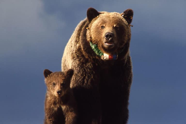
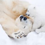
Grizzly Bear
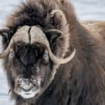
Hump, claws, and wild omnivory
Hump, claws, and wild omnivory
Low-flying hunter of open skies
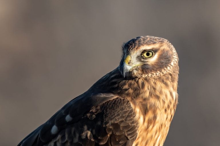
White-browed shadow of the woods
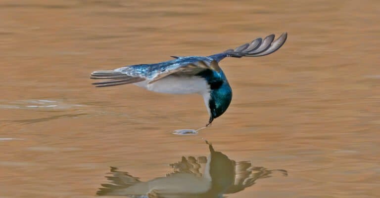
Sky-sleek hunter of wetland air
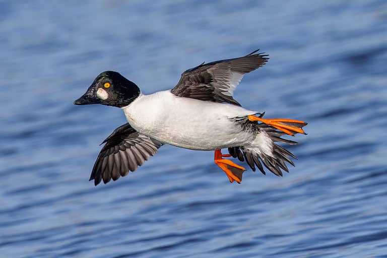
Hear the whistler, spot the gold eye
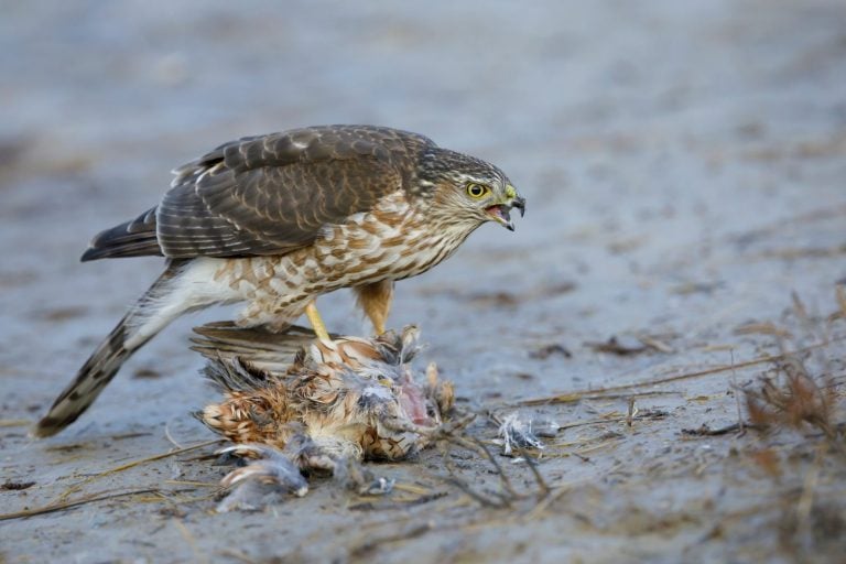
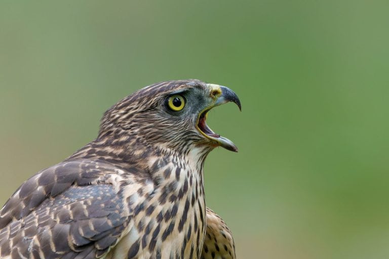
Small hawk, big speed in the woods
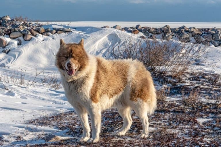
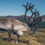
Built for the North. Born to pull.

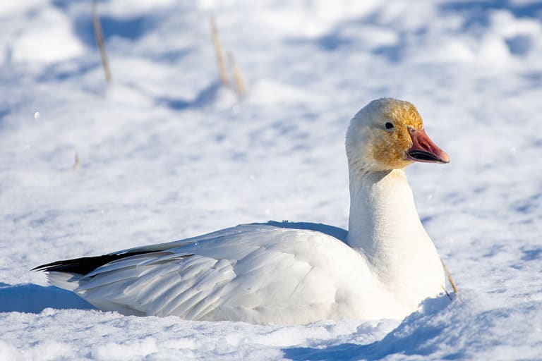
Bicolored tail, big-range survivor
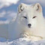
Two morphs, one Arctic traveler
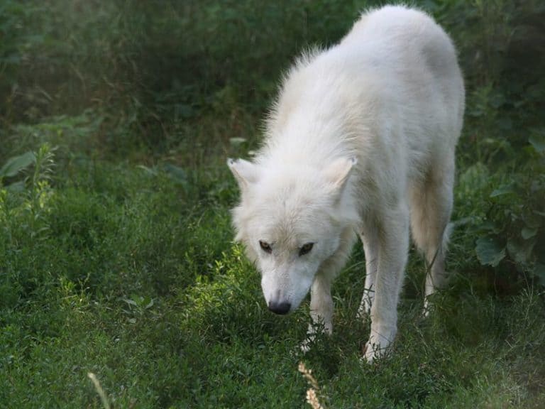
Built for the High Arctic
Nunavut is a vast, sparsely lived Arctic territory where sea and land blend into one of the most intact cold ecosystems on Earth. Life here is shaped by short, bright summers and long winters when sea ice is used for hunting, travel, and survival. It is a stronghold for Arctic species and an important nursery and feeding area for marine mammals and seabirds. Key habitats include the sea-ice edge (a biological hotspot), polynyas (repeating open-water areas), and wide tundra with wetlands and river valleys that support waterfowl, shorebirds, and caribou. Coastal cliffs and islands host seabird colonies, and channels and sounds are important paths for narwhals, belugas, and bowhead whales. Low human footprint and sea-ice driven ecology make wildlife viewing here remote and special.
Nunavut's vast Arctic land—tundra mainland and a large Arctic Archipelago coast—creates many habitats that shape wildlife. Inland Canadian Shield uplands, river valleys, and wetlands support caribou, muskoxen, wolves, and migratory bird breeding. The marine edge (sea ice, polynyas, fjords, shallows) is key for polar bears, seals, walrus, whales, and seabirds.
Sea level to ~2,616 m (Barbeau Peak, Ellesmere Island)
Extensive, highly indented Arctic coastline spanning the Arctic Ocean and major marine basins including Hudson Bay, Foxe Basin, Baffin Bay, and Davis Strait, with numerous channels, inlets, and fjords across the Arctic Archipelago.
Designated 2000
Designated 2000
Designated 2000
Nunavut's protected areas include Parks Canada national parks, Migratory Bird Sanctuaries, National Wildlife Areas, and smaller territorial parks near communities. Protection focuses on Arctic tundra, polar desert, seabird colonies, and marine/sea-ice habitats used by marine mammals. Much land is roadless with few buildings, and protection is focused in High Arctic islands, Baffin, Hudson Bay lowlands, polynyas, and migration corridors.
Approximately ~12-14% of Nunavut's land and inland waters are in protected/conserved areas (varies by definition and whether marine protected areas are included).
One of the world's most northerly parks, protecting polar desert and High Arctic ecosystems that support specialized wildlife and important denning/foraging habitat in an extreme climate.
A globally important Arctic marine-and-seabird landscape with ice edges, fjords, and major breeding colonies; excellent for viewing marine mammals and seabirds tied to sea-ice productivity.
Protects dramatic Arctic Cordillera landscapes (glaciers, fjords, and alpine tundra) that support cliff-nesting birds and coastal/nearshore marine mammal use during the open-water season.
A major tundra-coastal ecosystem around Wager Bay with important denning habitat, migratory bird staging areas, and seasonal concentrations of marine mammals and caribou.
Established to protect key High Arctic habitat for imperiled Peary caribou and other polar desert species, including critical calving/foraging areas and predator-prey dynamics in a sparse ecosystem.
Small but accessible tundra-and-river habitat valued for Arctic char runs, migratory birds, and opportunities to view tundra wildlife near the capital.
Protects a major river corridor and surrounding tundra important for fish, raptors, and migrating birds; noted for wilderness travel and wildlife viewing along the Soper River valley.
Known for dense nesting and staging waterfowl and shorebirds in the eastern Arctic; overlaps with highly significant bird habitat on Southampton Island.
A key river-and-canyon site on the Coppermine River that supports fish and raptors and serves as a wildlife travel corridor in the Kitikmeot region.
One of the most important nesting and staging areas for Arctic-breeding waterfowl in North America, supporting enormous seasonal bird concentrations across tundra wetlands.
Internationally significant seabird and waterfowl breeding area (including large goose colonies) that also supports predators and marine mammals along the coastal margin.
Protects a rare High Arctic wetland corridor critical for migrating and breeding birds and for High Arctic mammals; also important for polar bear movement and seasonal use.
Nunavut's wildlife is defined by Arctic tundra, vast sea-ice ecosystems, polynyas (recurring open-water areas), and some of the planet's most intact marine mammal habitats. Diversity is lower than in southern Canada, but biomass and spectacle can be extraordinary-large marine mammals (whales, seals, walrus), wide-ranging predators (polar bear), immense seabird colonies on cliffs and islands, and migratory pulses of waterfowl and shorebirds. Many species are highly specialized to cold, ice, and short productive summers, making the territory a bellwether for climate-driven change.

Nunavut has iconic Arctic wildlife across sea ice, tundra, and coastal fjords. You can see polar bears, narwhals, belugas, bowhead whales, walrus, muskoxen, Arctic foxes and caribou (seasonal), plus big seabird colonies. Wildlife follows sea-ice breakup and freeze-up and bird breeding. Best trips use boats, local outfitters, or small planes to communities such as Iqaluit, Pond Inlet, and Cambridge Bay.
Classic ice season: long daylight returns, stable travel on sea ice (conditions permitting), and strong chances for Arctic fox and seals near leads/ice edges. Excellent for northern lights, winter birding surprises (ptarmigan), and culturally rich snowmobile and sled excursions with Inuit guides. Polar bear viewing can be possible in some areas but is highly variable and safety-managed.
Explosive birdlife as migratory birds arrive and nest; tundra begins to green. Sea ice starts to shift and open-timing varies widely by region/year-creating opportunities for viewing seals, walrus hauled out, and the first whale movements. Great season for hiking with wildlife awareness and for photography under 24-hour daylight in many regions.
Prime marine mammal season in many communities: narwhal and beluga viewing in parts of the Eastern Arctic, plus chances for bowhead whales. Seabird cliffs are active; tundra wildflowers peak; boat and expedition cruise access is at its best. Also the most reliable time for multi-day trips (still weather-dependent). Mosquitoes can be intense inland-pack accordingly.
Crisp light, fewer insects, and good chances to see walrus, late-season whales, and migrating birds. Tundra colors can be spectacular. As sea ice starts to form, travel changes fast; storms and early freeze-up can affect boats and flights. In some areas polar bear sightings rise along coasts, so viewing must follow local safety rules.
Deep winter is best for aurora plus cultural and wilderness experiences (dog teams where available, snowmobile travel, ice fishing) and for tracking wildlife signs. Direct wildlife sightings can be less predictable due to darkness and weather, but the Arctic atmosphere is unmatched. Specialized guided trips are recommended.
Nunavut spans mainland Arctic Canada and most of the Arctic Archipelago, producing a strong north-south gradient from low-shrub tundra near the treeline to High Arctic polar desert and extensive ice-dominated marine systems. Ecosystems are shaped by permafrost, short growing seasons, strong winds, and sea ice dynamics, with globally important habitat for migratory birds, caribou, marine mammals, and cold-adapted predators.
Dominant terrestrial biome across the mainland and most islands, ranging from dwarf-shrub and sedge tundra in the south (near the treeline) to sparse cushion-plant and moss/lichen communities in the High Arctic.
Most land area (~60-75%), especially Kivalliq/Kitikmeot mainland and lowlands of Baffin, Victoria, and many smaller islands
High Arctic polar desert with very low precipitation, thin soils, patterned ground, and extremely sparse vegetation (lichens, mosses, scattered forbs); common where exposure, dryness, and cold limit plant cover.
Substantial in the High Arctic islands (e.g., Ellesmere, Axel Heiberg) and exposed uplands (~10-25% of land, regionally dominant in the far north)
Mountain and high-elevation environments in the Arctic Cordillera with glaciers, nunataks, scree, and alpine tundra communities where ice-free; strong elevation-driven microclimates.
Patchy but prominent along the eastern Arctic Archipelago (Baffin and Ellesmere ranges; local dominance in mountainous areas)
A narrow southern fringe near the continental treeline includes open, stunted spruce-tamarack stands and forest-tundra transitions, often interspersed with wetlands and shrub tundra.
Small, localized band in the far south of mainland Nunavut (generally <5% of territory land area)
Vast networks of glacially carved lakes, ponds, and rivers (often ice-covered much of the year), supporting Arctic char, lake trout, and key breeding habitat for waterfowl and shorebirds.
Widespread throughout; locally dense in lowland shields and coastal plains (numerous lakes/ponds across much of the mainland and larger islands)
Permafrost-influenced wetlands (fens, marshy lake margins, peatlands) concentrated in lowlands and along river corridors; important for nesting birds and carbon storage where peat accumulates.
Patchy but extensive in mainland lowlands and some coastal plains (notably along the western Hudson Bay coast and interior lowlands); generally limited in the High Arctic
Arctic marine ecosystems dominated by seasonal and multi-year sea ice, polynyas, and productive ice-edge waters; critical for seals, walrus, whales (e.g., narwhal, beluga), seabirds, and polar bears.
Very extensive (Nunavut's coastline and surrounding waters span much of the Arctic Archipelago and Hudson Bay/Foxe Basin; sea-ice influence across most marine areas)
Low-shrub, graminoid, and lichen tundra across mainland and islands; strong microtopography from frost heave and polygonal ground; major caribou ranges and nesting areas for shorebirds.
Willow/birch shrub tundra concentrated in relatively warmer southern and riparian zones, including sheltered valleys and south-facing slopes near the treeline.
Arctic Cordillera mountains on Baffin and Ellesmere with steep relief, glaciated valleys, and cold-adapted alpine biota; key denning and nesting sites on cliffs and ledges.
Sea cliffs and inland escarpments used by nesting seabirds (e.g., thick-billed murres, kittiwakes) and raptors; especially around Lancaster Sound/Baffin Bay and rugged fjord coasts.
Large lakes (e.g., Nettilling Lake on Baffin Island-among Canada's largest) and countless smaller lakes that support Arctic char/lake trout and provide staging habitat for migratory birds.
Major river systems and braided channels (e.g., Thelon, Back, Coppermine, Kazan) with riparian willows, deltaic wetlands, and important fish runs and wildlife travel corridors.
Abundant tundra ponds and thaw-lake systems in lowlands; highly productive in summer for invertebrates and waterfowl despite long ice seasons.
Fens and wet sedge meadows in low-lying permafrost landscapes; crucial breeding habitat for geese and other waterfowl and important for nutrient cycling.
Shallow, seasonally flooded lake margins and river deltas with sedges and grasses; locally common in southern mainland lowlands and along broad river valleys.
Peat-accumulating wetlands where conditions allow (more common toward the southern mainland fringe); typically cold, waterlogged, and underlain by permafrost.
Sparse, open black spruce-tamarack stands at the extreme southern margin (forest-tundra ecotone), often interspersed with wetlands and shrub tundra.
Extensive Arctic coastline with barrier beaches, lagoons, tidal flats in places, and ice-scoured shores; critical haul-out and denning areas for marine mammals in some regions.
Gravel and sand beaches along Hudson Bay/Foxe Basin and parts of the archipelago; shaped by sea ice push, storm surges, and permafrost shoreline dynamics.
Ice-scoured bedrock and boulder shores common across the archipelago, with sparse intertidal life adapted to extreme seasonality and freezing conditions.
River mouths and deltas where freshwater meets marine waters (notably along Hudson Bay and some mainland Arctic coasts), providing nutrient-rich feeding areas for birds and fish.
Seasonally ice-covered offshore waters of Baffin Bay, Davis Strait approaches, Foxe Basin, and the central archipelago; productivity peaks at ice edges and polynyas.
Deep marine basins and troughs in adjacent Arctic waters (e.g., parts of Baffin Bay) supporting cold-water benthic communities and deepwater circulation regimes.
Continental shelf and fjord seabeds across the archipelago, including soft-sediment basins and rocky substrates; important benthic feeding grounds for walrus and other fauna.
Small, widely separated communities (e.g., Iqaluit, Rankin Inlet, Cambridge Bay) with concentrated local footprint amid otherwise largely intact landscapes.
Minimal to near-absent; limited to small-scale gardens/greenhouses and localized forage production in a few communities due to climate and soils.
Polar bears in Nunavut are essentially "marine" predators: most of their yearly calories come from seals caught on sea ice, and many bears can fast for months on land when the ice retreats.
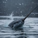
Narwhals summering in Nunavut's Arctic waterways (notably around Eclipse Sound and Admiralty Inlet) can dive to roughly 1,500 meters-deeper than many other toothed whales-yet return to breathe through small ice openings they maintain and revisit.
A narwhal's tusk isn't just a weapon: it's an elongated tooth packed with nerves, and research indicates it can sense changes in water (including salinity/temperature), turning the "unicorn horn" into a sensory tool.
Arctic char in Nunavut commonly live a double life: many populations are anadromous-spending part of the year feeding at sea, then migrating back into freshwater rivers and lakes-so a "freshwater fish" can be ocean-fed.
Snowy owl breeding in Nunavut is strongly tied to lemming booms; in high-lemming years, owls can nest at unusually high densities, then largely vanish from an area the next year when prey cycles crash.
Nunavut contains habitat for 12 of Canada's 13 polar bear subpopulations-more than any other Canadian jurisdiction-making it the country's largest polar-bear-management region by area and number of populations.
Foxe Basin (between Baffin Island and the Melville Peninsula, north of Hudson Bay) is documented as one of the highest-density polar bear areas on Earth, with bears concentrated around seasonal sea-ice edges and polynyas.
Nunavut's High Arctic islands (including Ellesmere and Axel Heiberg) are core range for Peary caribou, the northernmost caribou on the planet-living farther north than any other wild member of the deer family.
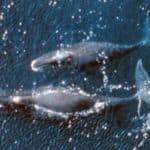
Baffin Bay and Lancaster Sound support bowhead whales-widely regarded as the longest-lived mammals on Earth (often 100+ years, with evidence some exceed ~200 years) and a signature superlative species in Nunavut waters.
Digges Sound Migratory Bird Sanctuary (at the mouth of Hudson Strait) hosts one of Canada's largest thick-billed murre colonies-on the order of hundreds of thousands of breeding birds-making it a nationally significant seabird "megacolony" site.
74 species documented in our encyclopedia
Thank you for reading! Have some feedback for us?
We appreciate your help in improving our content.
Our editorial team will review your suggestions and make any necessary updates.
There was an error submitting your feedback. Please try again.