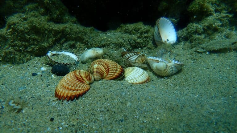
Cockle
Ribbed hearts of the tidal flats
Ribbed hearts of the tidal flats
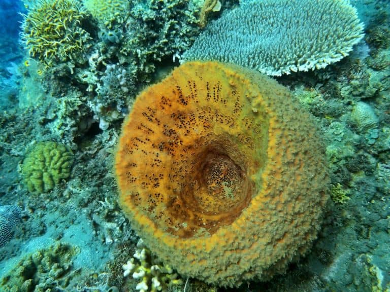
Porous powerhouses of the sea
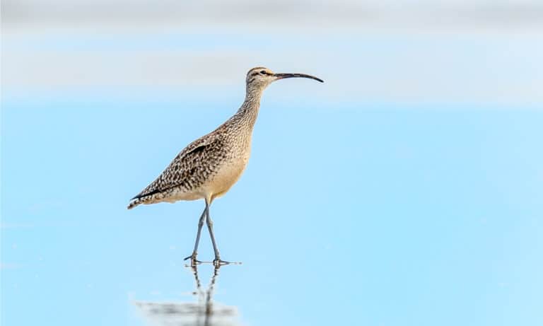
Curved bill, epic journeys
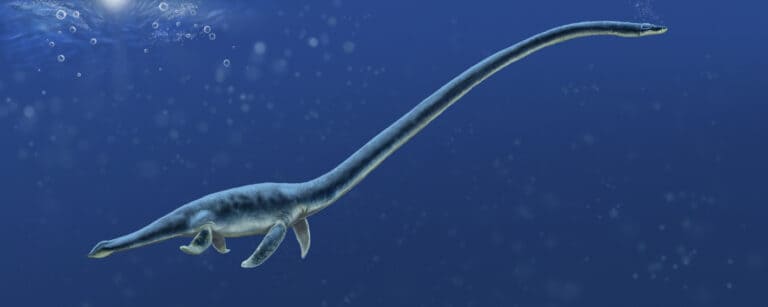
Four flippers, many lifestyles
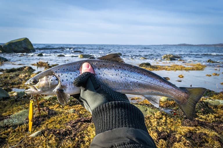
One fish, two worlds
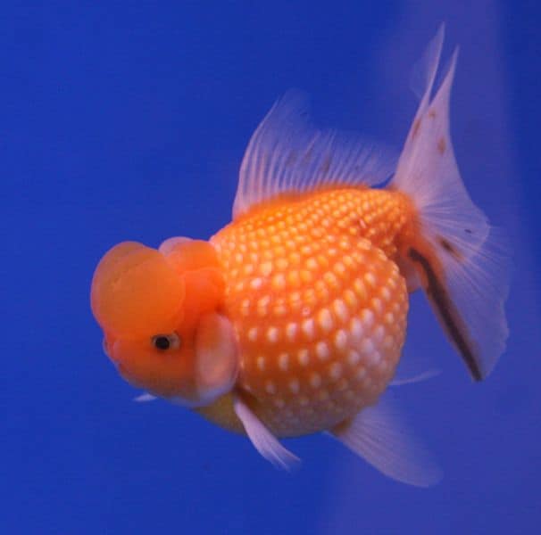
Bony rays, endless ways.
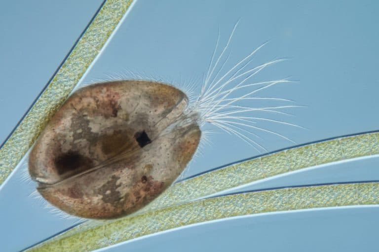
Tiny shells, huge history
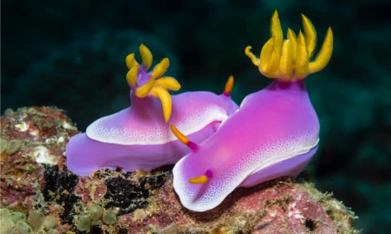
Nature's neon, toxin-borrowing sea slugs

Feathers, flight, and endless variety
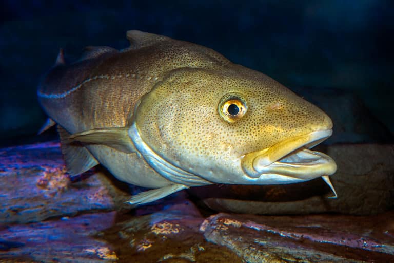
The barbel-chinned backbone of the Atlantic
The Baltic Sea is a semi-enclosed, brackish marginal sea of the northeastern Atlantic basin in northern Europe, connected to the North Sea through the Danish Straits and characterized by restricted water exchange and strong salinity stratification.
Bordered by Scandinavia, Finland, the Baltic states, Poland, Germany, and Russia, the Baltic Sea forms one of the world's largest bodies of brackish water. A narrow connection to the North Sea through the Danish Straits and a broad drainage basin with many rivers combine to keep salinity low and highly variable, creating a pronounced gradient from more saline conditions in the southwest to much fresher waters toward the north and east.
Because dense, saltier water enters only intermittently from the North Sea and mixes slowly with lighter freshwater at the surface, the Baltic commonly develops strong vertical stratification. This limits oxygen replenishment in deeper basins and makes the sea especially sensitive to nutrient enrichment from land. As a result, eutrophication-driven algal blooms, hypoxia and anoxia in deeper waters, and the accumulation of legacy pollutants are central features shaping Baltic ecology and management.
Etymology: The name "Baltic" is recorded in medieval Latin sources; its deeper origin is debated. Proposed roots include a Proto-Germanic element related to "belt" (often linked to the nearby Danish straits) and a Baltic-language root associated with "white" or "shining," but no single etymology is universally accepted.
Brackish, strongly stratified waters; limited exchange via Danish Straits; eutrophication/low-oxygen "dead zones"; exceptionally well-preserved shipwrecks and large archipelagos
The Baltic Sea is a brackish, semi-enclosed marginal sea in northern Europe. It lies between the Scandinavian Peninsula (Sweden and Finland) to the north and west, the Baltic States and Russia to the east, and Germany and Poland to the south. It connects to the North Sea (and onward to the Atlantic) through the Danish Straits between Denmark and southern Sweden.
Landsort Deep (near the Swedish coast, north of Gotland)
Southwestern gateway via the Danish Straits; includes islands and straits that control exchange with the North Sea.
Southern coastline along the western Baltic; includes bays and lagoons (e.g., Bay of Kiel, Mecklenburg Bay area).
Southern coast; includes the Gulf of Gdansk and the Vistula and Szczecin Lagoons (brackish coastal waters).
Southeastern coast; notably the Curonian Lagoon and adjacent nearshore Baltic waters.
Eastern/southeastern coasts including Kaliningrad Oblast; also the eastern Gulf of Finland around Saint Petersburg.
Eastern/southeastern coast; includes the entrance region toward the Gulf of Riga.
Northeastern coast; includes extensive islands and shallow archipelagic waters leading toward the Gulf of Finland and Gulf of Riga.
Northern and northeastern coast; highly indented archipelago and the northern side of the Gulf of Finland and Bothnian regions.
Western and northern coasts; includes major basins (Baltic Proper margins), archipelagos, and the deepest point (Landsort Deep).
Bordered by Sweden (west and north), Finland (north and northeast), Russia (east, including the Gulf of Finland and the Kaliningrad region), Estonia, Latvia, Lithuania (southeast/east via the Baltic proper and adjacent coasts), Poland and Germany (south), and Denmark (southwest). The only oceanic outlet is through the Danish Straits (Oresund, Great Belt, Little Belt) into the Kattegat and then the North Sea. Major sub-basins and gulfs include the Gulf of Bothnia (north), Gulf of Finland (east), and Gulf of Riga (southeast).
Surface avg: ~6-10 °C (annual mean varies by sub-basin; cooler north, warmer south)
Deep avg: ~2-6 °C (deep basins often cold and relatively stable; can be slightly warmer in some deep halocline waters depending on inflows)
Strong horizontal and vertical salinity gradients: lowest in Bothnian Bay and near river mouths (~2-5 PSU), increasing toward Danish Straits/Kattegat (~15-20+ PSU). A persistent halocline limits vertical mixing; episodic North Sea inflows raise deep salinity in central/deep basins.
Winter: surface ~0-4 °C (often ice in Bothnian Bay/Gulf of Finland); Spring: rapid surface warming after ice melt; Summer: surface ~14-22 °C (warmest in south/shallows), thermocline typically ~10-30 m; Autumn: surface cooling and deepening mixed layer with storms
Predominantly wind-driven and estuarine (two-layer) circulation. Net surface outflow of low-salinity water through the Danish Straits toward the Kattegat/North Sea, with intermittent denser saline inflow at depth into the Baltic Proper. Sub-basin gyres and along-coast currents occur in the Baltic Proper, Gulf of Finland, Gulf of Bothnia; circulation is highly variable with wind forcing and bathymetry (sills/basins).
Microtidal to very weak astronomical tides (typically only a few cm to ~10-20 cm). Sea-level variability is dominated by wind setup/setdown and atmospheric pressure (storm surges), which can exceed tidal range and drive episodic exchange through the Danish Straits.
Brackish surface layer formed by large river runoff plus precipitation; relatively fresh, seasonally warmed/cooled, and oxygenated. Below, a denser saline layer from episodic North Sea (Major Baltic Inflows) occupies deep basins; renewal is intermittent, leading to long residence times. Deep waters can become oxygen-poor/anoxic between inflows, with elevated nutrients and hydrogen sulfide in the deepest parts during stagnation.
Strong, persistent stratification with a seasonal thermocline (summer) over a permanent halocline (often ~40-80 m in the Baltic Proper; depth varies by basin). The halocline suppresses vertical mixing, promotes long deep-water residence times, and contributes to widespread deep hypoxia/anoxia. Winter mixing can erode the thermocline but usually not the halocline except in shallower/northern areas.
Wind-driven coastal upwelling occurs episodically, especially along the Swedish east coast, the Baltic Proper coasts, and parts of the Gulf of Finland and southeastern Baltic. Upwelling brings cooler, nutrient-rich subsurface water to the surface, enhancing local productivity and sometimes influencing cyanobacteria dynamics; intensity depends on wind direction, coastline orientation, and stratification strength.
Very low salinity with pronounced gradients; limited exchange through shallow sills of the Danish Straits; frequent hypoxia/anoxia in deep basins due to stratification and eutrophication; episodic Major Baltic Inflows can rapidly change deep-water salinity/oxygenation; seasonal ice cover in the north; strong sensitivity to wind-driven sea-level changes and internal waves at the halocline; recurring late-summer cyanobacterial blooms (nitrogen-fixing) in nutrient-rich, stratified conditions.
The Baltic Sea has a cool temperate to cold-temperate maritime climate with strong continental influence, especially toward the north and east. Air and sea temperatures show a large annual range: relatively mild summers and cold winters, with pronounced north-south gradients (warmer and generally ice-free in the southwest; colder and seasonally ice-covered in the Gulf of Bothnia and Gulf of Finland). The basin's semi-enclosed geography and limited exchange through the Danish Straits promote strong vertical stratification (halocline) and make the surface layer highly responsive to atmospheric forcing and large freshwater inflow. Variability is strongly shaped by the North Atlantic Oscillation (NAO): positive NAO tends to bring milder, stormier winters with less ice; negative NAO favors colder winters and more extensive ice.
Winter (Dec-Mar): Cold air outbreaks are common, particularly in the north and east; frequent low-pressure passages bring strong winds and rapid sea-level set-up/set-down (storm surges). Surface waters cool to near freezing in northern basins; mixing can deepen in unstratified areas, while the permanent halocline limits full-depth ventilation in much of the central Baltic. Spring (Apr-May): Rapid warming and increasing stratification in the surface layer; river discharge peaks in many catchments, freshening coastal zones and enhancing the seasonal thermocline. Generally calmer than winter but can feature sharp wind shifts. Summer (Jun-Aug): Mild to warm conditions; sea surface temperatures are highest (often coolest offshore and warmer in shallow/coastal areas). Stable stratification is strongest, reducing vertical mixing; this favors surface warming and can exacerbate oxygen depletion at depth by limiting ventilation. Autumn (Sep-Nov): Cooling and frequent windy periods erode the seasonal thermocline, increasing mixing in the upper layer. This is a transition season with growing wave activity and the onset of stronger extratropical cyclones.
No tropical cyclones (hurricanes/typhoons) occur. Storminess is dominated by mid-latitude (extratropical) cyclones tracking from the North Atlantic/North Sea region into Scandinavia and the Baltic. Peak storm frequency and intensity occur in late autumn through winter (roughly Oct-Mar), when strong pressure gradients generate gale-force winds, high waves, and notable storm surges-especially in funnel-shaped gulfs and along shallow coasts. Occasional severe windstorms ("European windstorms") can produce widespread impacts; their year-to-year frequency is strongly modulated by NAO phase and the prevailing westerlies.
Seasonal sea ice is common in the Baltic, but extent varies greatly by winter severity. The northern basins-Bothnian Bay-typically freeze every winter, with landfast ice along coasts and drifting pack ice offshore. The Bothnian Sea freezes in most winters, especially in its northern and coastal parts, but its ice extent can be limited during mild winters. The Gulf of Finland and Gulf of Riga freeze in many winters, with ice coverage and duration decreasing toward the west and south. The central and southwestern Baltic Proper, the Danish Straits, and areas near the North Sea connection are often ice-free or only experience short-lived, patchy ice during cold winters. Typical ice season spans roughly Dec/Jan to Mar/Apr (longer in the far north). In severe winters, ice can extend far south into the Baltic Proper; in mild winters, ice may be largely confined to the northern gulfs. Ice thickness is generally greatest in sheltered northern bays and coastal fast-ice zones and thinner/more mobile in exposed areas.
The Baltic Sea is a cold-temperate, brackish, semi-enclosed sea with a strong salinity gradient (near-marine in the southwest to near-freshwater in the north and east). Limited exchange through the Danish Straits and strong stratification (often a halocline) restrict deep-water ventilation, making the system prone to hypoxia/anoxia in deeper basins. High riverine input and nutrient loading drive eutrophication, frequent cyanobacterial blooms, and large "dead zones," while extensive archipelagos and shallow coasts support important nursery, feeding, and migration habitats.
Overall species richness is constrained by low salinity and strong stratification: many fully marine taxa drop out toward the central/northern basins, while freshwater species increase, producing a steep biodiversity gradient from southwest to northeast. Communities are often dominated by euryhaline (salinity-tolerant) generalists and a smaller set of brackish-adapted specialists. Productivity can be high (especially in coastal zones), but eutrophication and bottom-water oxygen depletion simplify benthic communities and reduce habitat quality in deeper areas.
Species count: On the order of several thousand described multicellular species across the basin (often cited around ~6,000 when including algae and invertebrates), with local richness strongly varying by salinity zone and depth.
The Baltic Sea's neritic zone spans its extensive shallow coastal waters, archipelagos, lagoons, and estuaries where freshwater inflow from large river catchments mixes with brackish water. Strong horizontal salinity gradients (higher in the southwest, very low in the north and east) shape distinct coastal communities, with seagrass and macroalgal belts where light allows and soft-bottom bays dominated by reeds and benthic vegetation. These nearshore waters are highly seasonal: spring phytoplankton blooms follow ice-out, summer warming intensifies stratification, and autumn storms resuspend nutrients. Eutrophication and coastal development commonly drive high phytoplankton biomass, filamentous algal blooms, and periodic hypoxia in sheltered basins, altering nursery habitat quality for fish and invertebrates.
The pelagic zone is characterized by brackish, strongly stratified water columns with limited renewal from the North Sea through the Danish Straits. A halocline (and often a seasonal thermocline) separates fresher surface waters from saltier deep waters, restricting vertical mixing and promoting oxygen depletion in deeper basins. Primary production is dominated by phytoplankton with a pronounced spring bloom (often diatoms and dinoflagellates) followed by summer communities that can include nitrogen-fixing cyanobacteria in warm, nutrient-imbalanced conditions. Zooplankton assemblages shift with salinity and temperature and can be constrained by low salinity in northern areas, influencing fish recruitment and energy transfer to higher trophic levels.
The benthic zone ranges from rocky and vegetated coastal substrates to deep soft sediments in large basins. In deeper areas, persistent stratification and high organic loading from eutrophication lead to widespread hypoxia/anoxia, reducing biodiversity and creating "dead zones" where only tolerant microbes and a few invertebrates can persist. Where oxygen is available, soft-bottom communities include bivalves, polychaetes, amphipods, and crustaceans that bioturbate sediments and recycle nutrients; shallow hard bottoms support mussel beds, barnacles, and macroalgal communities. Benthic processes strongly regulate nutrient fluxes: oxygenated bottoms can retain and transform nutrients, while anoxic sediments can release phosphorus and exacerbate blooms (internal loading).
The demersal zone-waters just above the seabed-links pelagic production to bottom habitats through sinking organic matter and near-bottom foraging by fish. In the Baltic, demersal conditions are strongly controlled by oxygen availability and saline inflows: when deep waters are oxygenated, demersal fish and invertebrates expand into deeper feeding grounds; during hypoxic periods, habitats contract and organisms aggregate in shallower, better-oxygenated areas. Key demersal fishes include cod in the more saline southwestern and central regions, as well as flounder and other flatfishes; their distribution, spawning success, and prey access are tightly coupled to the halocline, near-bottom salinity, and oxygen levels.
Notable migrations include seasonal movements of Atlantic herring and sprat between feeding areas and spawning grounds (often peaking in spring and early summer for many coastal spawners), and anadromous salmonids (Atlantic salmon and sea trout) that migrate from the sea into rivers to spawn (typically late summer to autumn, varying by river and stock). European eel undertakes a long-distance catadromous migration out of the Baltic toward the Sargasso Sea (primarily as silver eels in autumn). Many seabirds and waterfowl also show strong seasonal migration and staging in coastal and archipelago areas, tracking ice conditions and prey availability.
Core food webs begin with phytoplankton (spring diatom/dinoflagellate blooms and summer cyanobacteria) and microbial loops that recycle dissolved organic matter. Primary production is grazed by zooplankton (copepods, cladocerans, rotifers) and benthic filter feeders (e.g., mussels in suitable salinities), transferring energy to forage fish such as herring and sprat. Predatory fishes (notably cod where oxygen and salinity permit, plus pikeperch and perch in more coastal/brackish-fresh transition areas) consume forage fish and larger invertebrates; seals and piscivorous seabirds (e.g., cormorants, auks, gulls) sit higher in the web. Eutrophication strengthens the pathway from phytoplankton to detritus, increasing sedimentation and fueling benthic microbial decomposition; when oxygen is depleted, benthic food webs collapse and nutrient recycling can shift toward internal phosphorus release, reinforcing pelagic blooms and creating feedbacks that restructure the entire trophic network.
The Baltic Sea is a highly stressed, semi-enclosed brackish system with limited water exchange and strong stratification, making it exceptionally vulnerable to nutrient enrichment, contaminant accumulation, and oxygen depletion. Despite long-running regional cooperation and some reductions in point-source pollution, many basins remain eutrophic, with recurring cyanobacterial blooms, hypoxic/anoxic bottom waters ("dead zones"), degraded coastal habitats, and several fish stocks under pressure. Climate-driven warming and changing salinity/ice conditions increasingly compound these issues and can slow ecological recovery.
Poor to moderate ecological condition; chronically eutrophic with persistent hypoxia and contaminated sediments in several sub-basins
Excess nitrogen and phosphorus inputs from agriculture, wastewater, and atmospheric deposition drive eutrophication, harmful algal blooms, and widespread bottom-water hypoxia; legacy contaminants (e.g., PCBs, dioxins, mercury) persist in sediments and biota, with growing concern over pharmaceuticals and microplastics.
Historical and ongoing fishing pressure has contributed to depleted or stressed stocks in parts of the sea (notably cod in some areas) and can alter food webs; bycatch affects seabirds and marine mammals locally.
Warming, reduced ice cover, altered precipitation/runoff, and marine heatwaves influence stratification, oxygen conditions, phenology, and species distributions; episodic saline inflows that ventilate deep basins may change, affecting deep-water oxygenation.
Coastal development, dredging, shoreline hardening, and seabed disturbance reduce or fragment key habitats such as seagrass meadows, shallow spawning/nursery grounds, and coastal wetlands that filter nutrients and support biodiversity.
Non-native species introduced via shipping (ballast water/hull fouling) and canals can outcompete natives and restructure food webs; the brackish environment favors adaptable invaders.
Intensive agriculture across the catchment increases nutrient runoff and soil erosion; drainage and loss of riparian buffers/wetlands reduce nutrient retention before water reaches the sea.
Shipping lanes, port expansion, offshore wind, cables/pipelines, and dredging increase noise, collision risk, seabed disturbance, and can degrade sensitive coastal and benthic areas if poorly sited.
Heavy vessel traffic, recreation, and coastal tourism disturb breeding/haul-out sites for seabirds and seals and increase underwater noise and strike risk in localized areas.
Disease outbreaks and health stressors in marine mammals and fish can be exacerbated by contaminants, poor nutritional status, and warming waters, increasing susceptibility and mortality risks.
River regulation, altered freshwater inflows, wetland drainage, and coastal engineering change salinity gradients, sediment transport, and nutrient cycling, reducing the system's resilience.
Severe eutrophication from nutrient loading (N, P) causes recurring cyanobacterial blooms, reduced water clarity, and extensive hypoxia/anoxia; contaminated sediments and fish advisories persist in some areas due to POPs (e.g., PCBs/dioxins) and heavy metals (e.g., mercury), alongside emerging pollutants (pharmaceuticals, PFAS in some catchments) and widespread microplastics.
Mixed status across stocks and sub-basins; some stocks remain depleted or fragile and require low exploitation and improved compliance/monitoring. Food-web effects and bycatch remain concerns, especially where habitats are degraded.
Warming and reduced ice cover lengthen stratification seasons and can worsen oxygen depletion; changing precipitation/runoff alters salinity and nutrient delivery; ocean acidification is progressing and may affect calcifiers and early life stages, with combined stress from low alkalinity in parts of the Baltic.
Shipping-mediated introductions remain a key pathway; established invaders (e.g., round goby in many areas) and other non-natives can reshape coastal food webs and compete with native brackish specialists.
A chain of narrow passages connecting the Baltic Sea to the Kattegat/North Sea system, controlling most saltwater inflow and overall water exchange.
Crucial gateway governing Baltic salinity and deep-water renewal; historically strategic shipping chokepoint between Scandinavia and continental Europe.
An eastern arm of the Baltic between Finland and Estonia, extending to Russia; heavily influenced by river inflow and strong seasonal ice.
Major ecological and geopolitical sub-basin; receives large nutrient and pollutant loads and is central to regional eutrophication and conservation efforts.
The northernmost Baltic basin between Sweden and Finland, subdivided into the Bothnian Sea and Bothnian Bay; very low salinity and extensive winter ice cover.
Represents the freshest, coldest Baltic conditions; important for understanding climate/ice dynamics and for large-scale freshwater-driven ecosystem processes.
A Finnish marine protected area along the west coast of Finland in the Bothnian Sea, featuring shallow archipelago waters, reefs, and bird habitats.
Safeguards key coastal habitats in a low-salinity environment and supports migratory birds and marine biodiversity in one of the Baltic's least saline regions.
A coastal and archipelago World Heritage area spanning Sweden's High Coast and Finland's Kvarken Archipelago, shaped by ongoing post-glacial land uplift.
UNESCO World Heritage property recognized for exceptionally rapid post-glacial (isostatic) rebound, illustrating how land uplift and changing relative sea level reshape Baltic coastal landscapes and habitats.
Large limestone island in the central Baltic Sea with extensive coastal cliffs, shallow reef-like limestone structures, and surrounding brackish waters.
Iconic central-Baltic island with distinctive geology and coastal habitats; also historically important for Baltic trade routes and maritime archaeology.
Danish island in the southwestern Baltic with rocky coasts and nearby deep basins and fronts that influence local circulation.
A prominent navigation and fisheries area; its surroundings are important for studying mixing and exchange between southwestern Baltic sub-basins.
A southern Baltic bay off Poland, influenced by the Vistula River and coastal currents; includes major ports and sandy coastal habitats.
Economically vital shipping and industrial region; also a hotspot for nutrient inputs and coastal eutrophication research and management.
A deep basin west of Rügen and north of Bornholm forming part of the southwestern Baltic's deeper-water system.
One of the key basins involved in inflow events and deep-water ventilation; relevant to oxygen dynamics under strong stratification.
The deepest point of the Baltic Sea (in the Stockholm archipelago region), a deep basin with persistent stratification and low-oxygen bottom waters.
Flagship site for studying Baltic anoxia, nutrient cycling, and long-term environmental change; an iconic "deep" in an otherwise shallow sea.
A shallow submarine sill (submerged threshold) in the entrance region between the Belt Sea/Danish Straits and the deeper Baltic basins that restricts dense saltwater inflows.
A critical control point for major Baltic inflow events; strongly influences deep-water renewal and the spread of oxygenated, saltier water.
The Swedish warship Vasa sank on its maiden voyage in 1628 in Stockholm Harbor (Baltic Sea). The wreck was salvaged in 1961 and the ship is now preserved and displayed at the Vasa Museum.
A world-famous example of exceptional preservation in Baltic brackish waters and a landmark in maritime archaeology and conservation.
Wreck of the passenger ferry MS Estonia, which sank in 1994 in the northern Baltic proper, resting on the seabed at significant depth.
One of Europe's most notable modern maritime disasters; the site is historically and legally sensitive and central to Baltic maritime safety history.
Coastal waters around the historic Suomenlinna fortifications include submerged cultural features and nearby wreck-diving opportunities typical of the Gulf of Finland.
Combines cultural heritage with accessible Baltic diving; illustrates the long maritime-military history of the region and the Baltic's preservation of underwater artifacts.
A small limestone island west of Gotland with steep cliffs and surrounding shallow rocky habitats.
Famous for seabird colonies and protected nature; a notable biodiversity and conservation site in the central Baltic.
A long sandy spit and lagoon system along Lithuania and Russia (Kaliningrad), connected to the Baltic by a narrow strait-like inlet.
UNESCO-listed cultural landscape; a major coastal sediment and habitat system sensitive to eutrophication and coastal engineering impacts.
The Baltic Sea has been a major corridor for north European trade and cultural exchange since antiquity, linking the river systems of central and eastern Europe to the North Sea via the Danish Straits. Early networks included the Amber Road (moving Baltic amber south into Roman-era markets) and extensive Viking Age sailing routes (8th-11th centuries) connecting Scandinavia with the southern and eastern Baltic coasts, the Gulf of Finland, and onward into riverine routes toward Novgorod, Kyiv, and Byzantium. In the late medieval and early modern periods, the Hanseatic League (13th-17th centuries) organized a dense maritime trade system around Baltic ports (e.g., Lubeck, Tallinn, Riga, Gdansk), moving grain, timber, tar/pitch, flax, and furs, shaping urban development and mercantile institutions. Control of Baltic sea lanes was a recurring driver of conflict and state formation (e.g., Swedish-Polish-Danish rivalries, Russia's push to the sea under Peter the Great, and shifting borders in the 20th century). The Baltic's brackish, low-oxygen-prone basins have also preserved large numbers of historic wrecks, making underwater cultural heritage a prominent feature of the region.
Shipping is intense and concentrated along north-south and west-east corridors that funnel through the Danish Straits (Oresund Strait, Great Belt, Little Belt), making these passages critical chokepoints for Baltic trade. Major routes connect the North Sea/English Channel to the principal Baltic hubs: (1) Gulf of Finland traffic to/from St. Petersburg and Helsinki; (2) east Baltic routes to Tallinn and Riga; (3) south Baltic routes to Gdansk-Gdynia and Szczecin-Swinoujscie; (4) central Baltic routes serving Stockholm and the Aland/Archipelago Sea area; and (5) connections to the Bothnian Sea and Bay of Bothnia for forestry and mining exports (e.g., Lulea, Kemi/Tornio). Key ports and gateways include Copenhagen-Malmo region (including trans-Oresund logistics), Gothenburg as a major Scandinavian North Sea outlet (often linked intermodally to Baltic flows), Rostock and Lubeck/Travemunde (Germany), Kiel (via the Kiel Canal to the North Sea), Gdansk-Gdynia and Swinoujscie/Szczecin (Poland), Klaipeda (Lithuania), Riga and Ventspils (Latvia), Tallinn/Muuga (Estonia), Helsinki and Kotka-Hamina (Finland), Stockholm/Nynashamn (Sweden), St. Petersburg/Ust-Luga/Primorsk area (Russia), and Aarhus and other Danish ports supporting feeder networks. Typical cargoes include containers, Ro-Ro freight and passengers (dense ferry networks), timber and pulp, metals and ores, fertilizers, petroleum products, LNG, and bulk grain. Seasonal sea-ice in the north (Bothnian Bay) drives icebreaking operations and winter navigation constraints.
Commercial fishing operates under national and EU/ICES management (for most coastal states) with strong emphasis on quotas, seasonal closures, and stock recovery, reflecting pressures from eutrophication, habitat change, and variable recruitment in brackish conditions. Key commercial fisheries include pelagic trawling for sprat and herring (often for fishmeal/fishoil and food markets), demersal fisheries for cod in deeper basins (notably the eastern/central Baltic, though stocks have been under severe stress), and coastal net and trap fisheries. Environmental conditions-low salinity, stratification, hypoxia, and periodic saltwater inflows-strongly affect spawning success and distribution, especially for cod and benthic species.
Small-scale and artisanal fisheries remain culturally and locally important along archipelagos and sheltered coasts (e.g., Swedish and Finnish archipelagos, Estonia's islands, Polish and German lagoons, and parts of the Gulf of Riga and Gulf of Finland). Common methods include gillnets, fyke nets, fish traps, hook-and-line, and seasonal coastal seining where permitted. These fisheries often target mixed nearshore assemblages and are closely tied to local food traditions, recreational angling, and seasonal tourism; they are also sensitive to coastal habitat changes (reed expansion, eutrophication) and changing predator-prey dynamics.
Diving conditions vary widely: visibility can be good around rocky archipelagos and in colder seasons but is often reduced by plankton blooms and suspended sediments, particularly in eutrophic bays and near river mouths. The Baltic's low salinity limits shipworm activity, which helps preserve wooden wrecks exceptionally well; however, strong stratification and hypoxia/anoxia in deeper basins can create hazardous conditions and restrict benthic life. Temperatures are cold much of the year, requiring drysuits; currents are generally modest but can be stronger in straits and around headlands. Many notable wrecks are in protected or permit-controlled areas due to cultural heritage regulations.
Tourism is centered on coastal cities, island/archipelago recreation, beach destinations, and heritage travel. Popular activities include ferry cruising and short sea crossings (high-frequency passenger routes around Sweden-Finland-Estonia and across the southern Baltic), sailing and yachting in sheltered archipelagos (Stockholm Archipelago, Aland Islands, Finnish Archipelago Sea), kayaking and nature tourism in coastal parks and lagoons, and summer beach tourism along sandy coasts (e.g., Poland's Baltic coast around the Hel Peninsula and Sopot area, Germany's Mecklenburg-Vorpommern and islands such as Rugen/Usedom, Lithuania's Curonian Spit, Latvia's Jurmala, and parts of southern Sweden). Urban destinations leverage maritime heritage: Stockholm, Helsinki, Tallinn (UNESCO old town), Riga, Gdansk, Copenhagen/Malmo, and coastal spa towns. Wildlife tourism includes birdwatching in migration corridors and wetlands (e.g., lagoons and deltas), seal watching in some areas, and seasonal events tied to midsummer and coastal festivals.
The Baltic Sea is not a major upstream hydrocarbon province compared with the North Sea, but there have been localized extraction activities and ongoing transport of oil and petroleum products. Notably, offshore oil production has occurred in the Polish sector (e.g., the B3 field historically) and limited development/interest has existed in adjacent areas; however, environmental sensitivity, regulatory constraints, and public opposition limit expansion in many jurisdictions. The region's most significant hydrocarbon-related human activity is shipping and terminal logistics-large volumes of crude and refined products move through Baltic ports (especially from the eastern Baltic), creating spill-risk hotspots along main routes and in narrow straits. Natural gas infrastructure is prominent: subsea pipelines and LNG terminals support regional energy supply, though these are primarily transport/import facilities rather than extraction sites within the sea itself.
The Baltic Sea is strategically important due to its semi-enclosed geography, dense maritime traffic, critical energy and data infrastructure (ports, subsea cables, and pipelines), and proximity of multiple NATO and non-NATO states. Naval and air forces maintain active presence for surveillance, deterrence, mine countermeasures, and protection of sea lines of communication, with frequent multinational exercises. The region retains extensive legacy sea mines and unexploded ordnance from the World Wars, influencing naval operations and seabed activities. Key strategic focal points include the Danish Straits chokepoints, the Gulf of Finland approaches, the vicinity of Kaliningrad, and the central Baltic corridors linking Sweden/Finland with the Baltic states and Poland/Germany.
The Baltic littoral encompasses diverse coastal cultures shaped by maritime trade, fisheries, and archipelago life. Major cultural regions include Scandinavian coastal and island communities in Denmark, Sweden, and Finland (with strong sailing, ferry, and archipelago traditions); Baltic national coastal cultures in Estonia, Latvia, and Lithuania (historic Hanseatic urban influences and strong links to island and lagoon livelihoods); German and Polish Pomeranian/Kashubian coastal communities with distinctive language and traditions (notably Kashubians in northern Poland); and Russian coastal populations around the Gulf of Finland and Kaliningrad. Indigenous and minority groups include the Sami in northern Scandinavia (primarily inland but connected to coastal northern waters via regional livelihoods), the Livonians (historically along Latvia's coast), and the Seto/Voro cultural regions near the southeast Baltic hinterlands. Across the region, shared maritime heritage is expressed through coastal architecture, fish-smoking and preservation cuisines, seafaring folklore, and annual festivals tied to midsummer and seaborne commerce.
81 species documented in our encyclopedia
Thank you for reading! Have some feedback for us?
We appreciate your help in improving our content.
Our editorial team will review your suggestions and make any necessary updates.
There was an error submitting your feedback. Please try again.