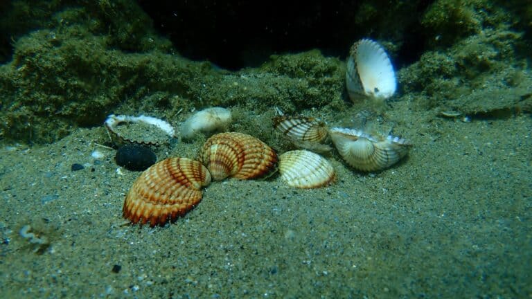
Cockle
Ribbed hearts of the tidal flats
Ribbed hearts of the tidal flats
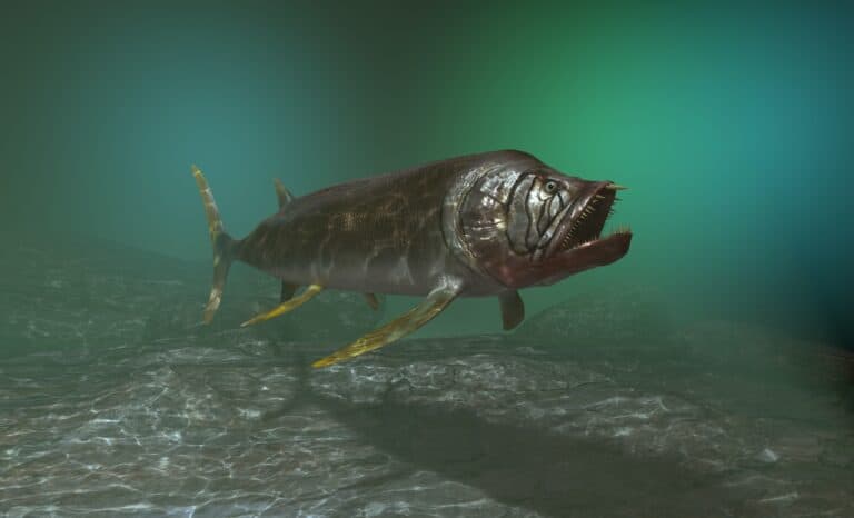
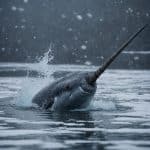
Not a dinosaur-Cretaceous sea predator

Tiny fly, mighty bite.
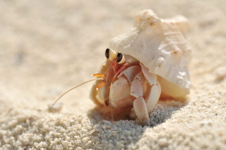
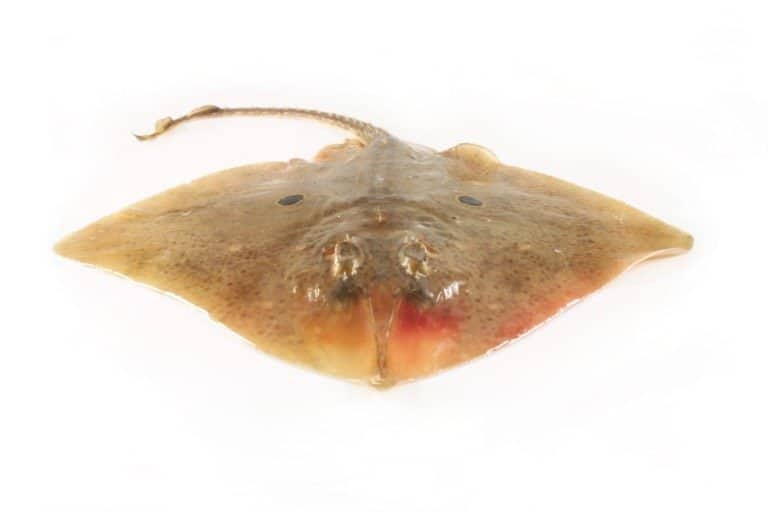
Borrowed shells, bold lives
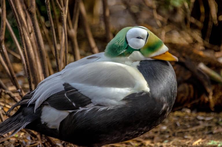
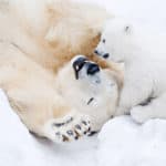
Downy divers of the far north

One phylum, endless forms
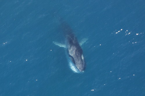
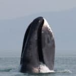
The fast rorqual with a split-color jaw
Glide low, hunt slow.
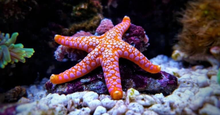
Hydraulic feet, star-shaped predators
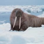
Calico traveler of the North Pacific
The Arctic Ocean is the smallest and shallowest of Earth's major oceans, occupying the polar basin around the North Pole and bounded by the northern coasts of Eurasia and North America and connected to the Atlantic and Pacific via narrow gateways.
Centered on the North Pole, the Arctic Ocean is a polar marine basin where sea ice is a dominant physical feature, expanding and thickening through winter and retreating in summer to varying degrees across regions. Its surface waters are typically cold and relatively fresh compared with other oceans, shaped by substantial river discharge from Siberia and North America, precipitation, and seasonal sea-ice melt that create strong stratification and influence circulation.
Despite extreme seasonality in light and temperature, the Arctic Ocean supports highly specialized ecosystems. Sea ice provides habitat for ice-associated algae and invertebrates that form the base of food webs leading to fish, seabirds, and marine mammals such as seals, walrus, and polar bears. Ecological productivity is often concentrated along the ice edge, continental shelves, and polynyas (recurring open-water areas), where nutrient supply and sunlight can align during the brief polar summer.
Oceanographically, the Arctic acts as a key component of the global climate system. Exchanges with the Atlantic and Pacific, the formation and export of sea ice, and the production of cold, dense waters that contribute to broader overturning circulation link the region to lower latitudes. Rapid changes in sea-ice extent and thickness are reshaping habitats and altering physical conditions, making the Arctic Ocean an important focus for climate, ecosystem, and geopolitics research.
Etymology: "Arctic" comes from Ancient Greek, meaning "of the bear," from a word meaning "bear." The term refers to the northern sky constellations (Ursa Major and Ursa Minor) used to denote the far north; thus "Arctic Ocean" is often glossed as the "Ocean of the Bear" (north).
Seasonal/year-round sea ice, polar marine ecosystems, climate-change indicator, Northern Sea Route & Northwest Passage
The Arctic Ocean lies in the Northern Hemisphere around the North Pole, largely within the Arctic Circle. It is surrounded by the northern coasts of Eurasia and North America and is seasonally to perennially covered by sea ice, with cold, generally low-salinity surface waters influenced by major river inflow and ice melt.
Molloy Deep, Fram Strait (between Greenland and Svalbard)
Northern coast of Siberia, bordering multiple Arctic shelf seas (Kara, Laptev, East Siberian, Chukchi).
Arctic frontage via the Svalbard archipelago and adjacent Barents/Greenland Sea approaches.
Via Greenland's extensive Arctic coastline (Kingdom of Denmark).
Northern mainland and the Canadian Arctic Archipelago, bordering the Beaufort Sea and central Arctic waters.
Alaska's North Slope coastline along the Beaufort and Chukchi seas.
Bounded by the Arctic coasts of Russia, Norway (Svalbard), Greenland (Kingdom of Denmark), Canada, and the United States (Alaska). It connects to the North Atlantic primarily through the Fram Strait (between Greenland and Svalbard) and via the Greenland/Norwegian seas; it connects to the North Pacific through the Bering Strait between Alaska and Russia. Its margins include major shelf seas such as the Barents, Kara, Laptev, East Siberian, Chukchi, and Beaufort seas.
Surface avg: ~ -1.0 to 1.0°C (basin-wide typical annual mean; strongly variable by ice cover and proximity to inflows)
Deep avg: ~ -0.8 to 1.0°C (deep basin waters near ~-0.5 to 0°C; intermediate Atlantic-derived layers commonly ~0.5 to 2°C depending on region)
Surface salinity commonly ~28-33 PSU due to major river discharge (Ob, Yenisei, Lena, Mackenzie), precipitation, and sea-ice melt. Below the surface, salinity increases through the halocline to ~34-35 PSU in Atlantic-derived layers and deeper waters. Strong horizontal gradients exist (fresh shelves vs saltier inflow regions).
Winter: surface near freezing (~-1.8 to -1.5°C) under extensive ice; Summer: surface warms modestly in open-water and marginal ice zones (~0 to 6°C, locally higher in shallow coastal shelves). Subsurface Atlantic Water remains relatively warm year-round beneath the halocline.
Key systems include: (1) Beaufort Gyre (anticyclonic circulation retaining freshwater/sea ice in the Canada Basin); (2) Transpolar Drift (export pathway transporting sea ice and surface waters from Siberian shelves across the pole toward Fram Strait); (3) Atlantic inflow via Fram Strait and Barents Sea (West Spitsbergen Current bringing relatively warm/saline Atlantic Water into the Arctic, with return flows of colder waters via East Greenland Current); (4) Pacific inflow through Bering Strait (seasonal, nutrient-rich inflow influencing Chukchi/Beaufort shelves); (5) boundary currents along continental slopes that steer Atlantic/Pacific layers around the basins (e.g., along Eurasian and Canadian margins).
Generally small to moderate over deep basins (often microtidal to low mesotidal), but can be locally strong and dynamically important on shelves and straits. Notable enhanced tidal currents and mixing occur in narrow passages (e.g., Fram Strait, Bering Strait, Canadian Arctic Archipelago channels) and on broad shelves (Barents, Kara, Laptev, Chukchi), where tides can drive vertical mixing and influence ice formation/melt patterns.
A pronounced layered water-mass structure: (1) Polar Surface Water: cold, relatively fresh, strongly influenced by river runoff and ice melt; (2) Halocline Waters: cold, saltier than the surface, often formed on shelves via brine rejection during sea-ice formation and shelf-modified waters; acts as an insulating barrier; (3) Atlantic Water: warmer and saltier (typically ~0-3°C; ~34.8-35 PSU) entering via Fram Strait/Barents Sea and circulating at intermediate depths; (4) Pacific Summer/Winter Waters (in the western Arctic): cooler, nutrient-rich layers derived from Bering Strait inflow; (5) Arctic Deep Water: cold, relatively uniform deep/bottom waters with slow renewal, influenced by mixing and exchanges through Fram Strait and other gateways.
Very strong stratification is typical, dominated by salinity. A fresh, cold surface layer overlies a cold halocline; below lies warmer Atlantic Water. The halocline suppresses vertical heat transfer from Atlantic Water to the surface, helping maintain sea ice. Stratification can weaken regionally where Atlantic inflow is strong (e.g., parts of the Eurasian Basin/Barents Sea) or where intense mixing occurs on shelves and in straits.
Upwelling is generally patchy and seasonally dependent, strongest where winds, ice-ocean stress, and topography interact: (1) Shelf break upwelling along the Beaufort and Chukchi shelves under favorable winds (can bring nutrient-rich Pacific/halocline waters onto shelves); (2) Eurasian shelf break regions (e.g., Laptev/Kara margins) where storms and ice-edge dynamics can induce upwelling; (3) Polynya regions (e.g., North Water Polynya, coastal polynyas in the Laptev/Kara/Chukchi) where recurrent open water and brine-driven convection enhance nutrient supply and productivity; (4) Straits and sills (Fram Strait, Canadian Arctic Archipelago) where tidal mixing and topographic effects elevate nutrients into the euphotic zone.
Seasonal to perennial sea-ice cover strongly shapes air-sea exchange, light availability, and ecology; extreme seasonality in solar radiation drives brief but intense summer blooms near the ice edge and in polynyas. Large freshwater storage in the Beaufort Gyre can be released, altering stratification and downstream North Atlantic conditions. Sea-ice formation causes brine rejection that helps create/maintain the halocline. Ocean acidification signals can be amplified in cold, fresh surface waters (higher CO2 solubility and lower buffering). Rapid climate-driven change is prominent: declining ice thickness/extent, increased Atlantification/Pacification in some regions, and shifting timing/location of primary productivity and nutrient pathways.
The Arctic Ocean has a polar marine climate dominated by very low air and sea temperatures, long periods of darkness/light, and generally low precipitation (a "polar desert" in many areas). Surface waters are cold and relatively low-salinity due to large river inflows (e.g., from Eurasia and North America) and seasonal sea-ice melt, creating strong stratification that limits vertical mixing. Winds, sea-ice drift, and exchanges with the North Atlantic and North Pacific strongly shape regional conditions, supporting ecosystems adapted to ice-associated productivity and short, intense summer blooms.
Winter (roughly Oct-May): Persistent freezing conditions, extensive sea-ice growth and thickening, long polar night, very cold air outbreaks, and reduced biological activity under ice. Spring (May-Jun): Increasing sunlight triggers under-ice and marginal-ice-zone blooms as melt begins; ice starts to fracture and leads open. Summer (Jun-Sep): Cool but warmer relative conditions with continuous/long daylight; sea-ice retreats to a seasonal minimum (typically late Aug-Sep), meltwater freshens the surface, fog and low clouds can be common, and productivity peaks in open-water and ice-edge zones. Autumn (Sep-Oct): Rapid loss of sunlight and cooling; storms and wind-driven mixing increase; new ice forms and expands quickly.
No true hurricanes/typhoons form over the Arctic Ocean due to cold sea-surface temperatures and limited latent heat. Instead, the region is affected by extratropical cyclones (polar lows and larger mid-latitude-origin storms). Storm activity often peaks in late summer through autumn when sea-ice extent is lower and open water can enhance heat/moisture fluxes, sometimes deepening cyclones and increasing wave action. Winter also sees frequent cyclones along the Arctic frontal zone, but extensive ice cover can limit wave growth. These storms can drive rapid sea-ice motion, pressure ridging, coastal surges, and hazardous marine conditions.
Sea ice is a defining feature: extensive seasonal coverage with a large winter maximum and a late-summer minimum. Winter typically brings near-continuous ice cover across most of the basin, with thicker multi-year ice historically concentrated north of Greenland and the Canadian Arctic Archipelago. Summer melt opens leads and polynyas and expands open-water areas, especially in peripheral seas; the ice edge migrates substantially. Recent decades have seen a shift toward thinner, younger first-year ice and reduced late-summer extent, increasing the length of the open-water season in many regions while maintaining perennial ice in the coldest/most sheltered sectors.
The Arctic Ocean is a cold, strongly seasonal marine system dominated by sea-ice dynamics, extreme light regimes (polar night/midnight sun), and a freshened surface layer from river inflow and ice melt overlying saltier Atlantic/Pacific-derived waters. Ecological production is highly pulsed: short, intense phytoplankton and ice-algal blooms fuel food webs that are tightly coupled to sea ice, continental shelves, and recurring open-water areas (polynyas). Many organisms are specialized for freezing temperatures and ice-associated habitats, while overall species richness is generally lower than in temperate and tropical oceans, with localized biodiversity hotspots on shelves, slopes, and hard-bottom features.
Overall species richness is relatively low compared with lower-latitude oceans due to cold temperatures, strong seasonality, and extensive ice cover, but there are high-biomass seasonal blooms and localized hotspots (shelves, polynyas, fronts, and complex seafloor habitats). Communities include highly specialized ice-associated microbes and invertebrates, strong benthic-pelagic coupling on shallow shelves, and top predators reliant on sea ice and migratory prey.
Species count: ≈5,000-8,000 described marine species across the Arctic marine realm (with highest richness in benthic invertebrates; many taxa remain under-sampled, especially microbes and deep basins).
Arctic neritic (coastal) waters occur across broad continental shelves (e.g., Barents, Kara, Laptev, Beaufort), where river discharge, sea-ice formation/melt, and shallow depths create strong salinity and temperature gradients. In spring and early summer, ice-edge and polynya conditions concentrate light and nutrients, driving short, intense phytoplankton blooms and ice-algal production that fuel high seasonal productivity. Coastal habitats include fjords, estuaries, and nearshore lagoons that support Arctic cod nurseries, benthic filter-feeders, and marine mammals that track ice and prey. Productivity and species composition vary sharply with freshwater input, sea-ice duration, and Atlantic/Pacific water inflows, making shelves key hotspots for Arctic fisheries and wildlife.
The Arctic pelagic (open-ocean) zone is dominated by a cold, stratified surface layer with low salinity from ice melt and river inflow overlying warmer, saltier Atlantic- or Pacific-derived waters. Persistent sea ice and extreme seasonality in light limit primary production in winter and concentrate it into a brief summer window; blooms often form at the ice edge or beneath thinning ice where light penetrates. Zooplankton communities (notably large Calanus copepods) store energy as lipids to survive long dark periods, forming a crucial energy bridge to pelagic fishes, seabirds, and whales. Multi-year ice and drifting sea ice also act as mobile habitat, transporting ice-associated algae and invertebrates and influencing where pelagic feeding aggregations occur.
Arctic benthic (seafloor) ecosystems are shaped by cold temperatures, slow metabolism, and strong coupling to seasonal pulses of organic matter sinking from surface blooms (including ice-algal detritus). On shelves, relatively shallow depths allow high export of carbon to the bottom, supporting rich benthic communities of bivalves, polychaetes, amphipods, echinoderms, and sponges; in some areas, ice scouring and sediment disturbance create patchy mosaics of colonization stages. In deeper basins, food supply is lower and communities are sparser, with slow-growing organisms and long-lived species common. Benthic prey are central for walrus, gray whales (where present), diving seaducks, and bottom-feeding fishes, making the seafloor a major reservoir of Arctic biological production.
The demersal zone (near-bottom waters) in the Arctic links pelagic production to seafloor food webs via bentho-pelagic coupling, especially on shelves and shelf breaks where currents and fronts concentrate prey. Demersal fishes such as Arctic cod, saffron cod, sculpins, Greenland halibut, and other flatfishes forage on zooplankton, amphipods, and benthic invertebrates, while also serving as prey for seals, belugas, narwhals, and seabirds. Oxygen levels are generally sufficient, but temperature/salinity layering and episodic intrusions of Atlantic or Pacific waters can shift species distributions and alter predator-prey overlap. Seasonal ice cover affects demersal access for air-breathing predators and changes how organic matter is delivered to near-bottom habitats.
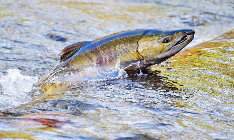
Migrations are strongly seasonal and track sea-ice retreat/advance, prey blooms, and access to breathing holes or open water. In spring-summer, many seabirds (auks, murres, kittiwakes, eiders) move north to breed and feed along productive ice edges and coastal polynyas; in autumn they disperse southward with declining light and increasing ice. Bowhead whales, belugas, and narwhals make annual movements between wintering areas near persistent ice/open-water refugia and summer feeding grounds along shelves, fjords, and ice margins; timing varies regionally but generally peaks from late spring through early fall. Ringed and bearded seals shift haul-out and foraging patterns with ice conditions, while walrus migrate between winter pack-ice habitats and summer coastal haul-outs near benthic feeding areas. Anadromous fishes (e.g., Arctic char, salmon in subarctic margins) move into coastal waters and rivers during the ice-free season, providing seasonal pulses of prey for marine predators and people.
Primary production is split between ice algae (early season, within/under sea ice) and phytoplankton blooms (ice-edge, polynyas, and open water in summer). These producers feed lipid-rich zooplankton (Calanus copepods), krill, and amphipods; Arctic cod often forms a pivotal mid-trophic link by converting zooplankton energy into accessible prey for seals (ringed, bearded), seabirds, and toothed whales (beluga, narwhal). A parallel benthic pathway is strong on shelves: sinking algal material fuels bivalves, worms, and benthic crustaceans, which in turn support walrus, diving ducks, and bottom-feeding fishes. Apex predators (polar bears in ice-associated systems, plus killer whales seasonally in some regions) rely on seals and large fish, with predator access and hunting success tightly coupled to sea-ice structure. Detrital recycling by microbes and scavengers is crucial because long winters and low temperatures slow decomposition, making seasonal "boom-bust" pulses of carbon and energy a defining feature of Arctic trophic dynamics.
The Arctic Ocean supports highly specialized, ice-dependent ecosystems (sea-ice algae, zooplankton, Arctic cod, seals, walrus, polar bears, and migratory seabirds) that are tightly coupled to seasonal sea-ice dynamics and cold, low-salinity surface waters influenced by river inflow and meltwater. Conservation status is increasingly compromised by rapid sea-ice loss, warming and acidification, and growing industrial access (shipping, oil and gas interest, and coastal development). While parts of the region benefit from large protected areas and strong international attention, the pace of physical change and expanding human activity is outstripping current safeguards in many places.
Stressed and vulnerable; ecosystem integrity is declining due to rapid climate-driven sea-ice loss and increasing industrial pressures.
Rapid warming, sea-ice thinning and loss, altered stratification and circulation, increased ocean acidification, and shifts in prey distribution reduce habitat and food-web stability for ice-dependent species and affect productivity timing (phenology).
Loss of sea-ice habitat (resting, breeding, hunting platforms) and changes to marginal ice zone and polynyas; coastal erosion and permafrost thaw affect nearshore habitats and sediment/nutrient inputs.
Long-range transported persistent organic pollutants (POPs) and mercury bioaccumulate in marine food webs; increasing risk of oil spills and black carbon deposition from shipping/extraction; microplastics and abandoned fishing gear occur even in remote waters.
Expansion of Arctic shipping routes, ports, coastal infrastructure, and potential hydrocarbon development increases noise, spill risk, icebreaking impacts, and disturbance in sensitive corridors.
Vessel traffic, icebreaking, seismic surveys, and tourism disturb marine mammals and seabirds; underwater noise can disrupt communication, migration, and foraging.
Some Arctic/sub-Arctic stocks are shifting northward; localized pressures and bycatch risks exist, and new fisheries may emerge as ice retreats (with governance gaps in some areas).
Cumulative extraction pressures (fish, hydrocarbons, and supporting resources) and increased access can reduce ecosystem resilience if not tightly managed.
Subsistence harvest remains culturally and food-security important; sustainability varies by species/region and can be stressed when populations are simultaneously impacted by climate change.
Warming and increased shipping raise the likelihood of non-native species introductions (via ballast water/hull fouling) and boreal species range expansions, potentially reshaping food webs.
Warming can facilitate novel pathogens/parasites and harmful algal blooms, increasing disease risk for marine mammals and seabirds, though monitoring remains limited.
Mining in Arctic watersheds and coastal zones can increase sediment and contaminant runoff; associated shipping and infrastructure elevate cumulative risk.
Legacy and ongoing long-range pollutants (POPs, mercury), increasing microplastics, and heightened oil-spill/black-carbon risk as shipping and extraction activity grow; contaminant biomagnification is a major concern for top predators and human communities reliant on subsistence foods.
High seas central Arctic fishing is currently constrained and governed by a precautionary moratorium framework, but adjacent shelf and sub-Arctic fisheries face shifting stock distributions and potential new fishery development; bycatch and ecosystem-based management remain key challenges.
Among the fastest-warming ocean regions: rapid sea-ice decline, longer open-water seasons, marine heat anomalies, altered primary production timing, increased coastal erosion, and strong/early impacts of ocean acidification (especially affecting calcifiers) that reverberate through the food web.
Historically limited by cold/ice, but risk is rising with warming and shipping; concerns include ballast-mediated introductions and northward expansion of boreal competitors/predators that can displace Arctic specialists.
Deep gateway between Greenland and Svalbard connecting the Arctic Ocean to the Greenland and Norwegian seas, with strong currents and shifting sea-ice edge.
Primary exchange corridor for Arctic sea ice and water masses; a key region for studying sea-ice export, ocean circulation, and climate change impacts.
Narrow, shallow passage between Alaska (USA) and Chukotka (Russia) linking the Pacific (Bering Sea) to the Arctic (Chukchi Sea).
Controls much of the Pacific inflow of heat, freshwater, and nutrients into the Arctic, strongly influencing sea-ice conditions and Arctic marine productivity.
Channel between northwest Greenland and Ellesmere Island connecting the Lincoln Sea/Arctic Ocean with Baffin Bay.
Major route for sea-ice export and the location of recurring ice arches that can block ice flow, affecting regional circulation and ecosystems.
An oceanographic (hydrographic) front in the Barents Sea where warmer, saltier Atlantic Water meets colder Arctic Water, producing sharp temperature and salinity gradients.
A key zone for high biological productivity and fisheries and a widely used indicator region for ongoing changes such as increased Atlantic Water influence ("Atlantification") in the Arctic.
Large submarine ridge running across the central Arctic Ocean from near Greenland/Canada toward Siberia, rising from deep basins.
A defining seafloor feature that divides the Eurasian and Amerasian basins; central to Arctic geologic history and international seabed/continental-shelf claims.
Ultra-slow-spreading mid-ocean ridge beneath the Eurasian Basin, extending from the North Atlantic into the Arctic Ocean.
One of Earth's slowest spreading centers; notable for deep, ice-covered hydrothermal activity and insights into seafloor formation under extreme conditions.
Deep depression in the Fram Strait area (near the Greenland Sea-Arctic boundary), among the deepest points associated with the Arctic region.
Represents extreme Arctic bathymetry and is important for understanding deep-water exchange and basin structure near the Arctic gateway.
Deep-water passage between Greenland and the Svalbard archipelago that connects the Arctic Ocean with the Greenland Sea (part of the North Atlantic).
Main gateway between the Arctic and Atlantic for ocean circulation and sea-ice export, strongly influencing Arctic heat transport, freshwater exchange, and climate-relevant ocean dynamics.
An Arctic marginal sea of the Arctic Ocean north of Alaska and northwestern Canada; its central basin hosts the wind-driven Beaufort Gyre circulation.
Major reservoir of freshwater in the Arctic; changes here affect sea ice, ocean salinity, and downstream North Atlantic conditions.
Russian Arctic island in the Chukchi Sea north of Siberia, surrounded by seasonally ice-covered waters.
UNESCO World Heritage area famed for high Arctic biodiversity and key habitat for polar bears, walrus, and seabirds tied to productive shelf waters.
Norwegian Arctic archipelago between mainland Norway and the North Pole, influenced by Atlantic inflow along its western side.
A major Arctic research hub and an accessible window into rapidly changing sea-ice, glacier, and marine ecosystem dynamics.
Vast protected area covering Greenland's remote northeastern coast and adjoining Arctic marine waters and fjords.
One of the world's largest protected regions, safeguarding critical high-Arctic marine habitats and serving as a reference for minimally impacted ecosystems.
The Arctic Ocean has long been a frontier for human movement, subsistence, and geopolitical ambition. Indigenous peoples (Inuit, Inupiat, Yupik, Sami, Nenets, Chukchi and others) developed sophisticated sea-ice travel, marine hunting, and coastal trade networks that predate modern state borders. European engagement intensified from the 16th-19th centuries through attempts to find northern trade routes to Asia (the Northwest Passage across the Canadian Arctic Archipelago and the Northern Sea Route along Siberia). Key milestones include early expeditions by Martin Frobisher and John Franklin (Northwest Passage search and tragedy), Fridtjof Nansen's Fram drift (1893-1896) demonstrating polar ocean currents, and Roald Amundsen's first successful navigation of the Northwest Passage (1903-1906). In the 20th century, the region gained Cold War strategic significance, with nuclear submarine transits and scientific expeditions (e.g., Soviet/Russian drifting ice stations). Contemporary exploration includes extensive oceanographic mapping, sea-ice monitoring, and seafloor surveys linked to continental shelf claims under UNCLOS.
Arctic shipping is highly seasonal and remains constrained by sea ice, limited search-and-rescue coverage, sparse infrastructure, and variable weather/visibility. The main corridors are: (1) Northern Sea Route (NSR) along Russia's Arctic coast, connecting the Barents/Kara/Laptev/East Siberian/Chukchi seas; it is used for domestic supply, LNG/oil export, and some Asia-Europe transits with icebreaker support. (2) Northwest Passage (NWP) through the Canadian Arctic Archipelago; used mainly by expedition/cruise vessels and occasional commercial transits, with complex choke points and ice hazards. (3) Transpolar Route (central Arctic) remains mostly prospective and episodic, not a stable lane yet. Key ports and hubs include Murmansk (ice-free Barents Sea gateway), Arkhangelsk, Sabetta (Yamal LNG export), Dudinka (Norilsk industrial supply), Pevek (Chukotka), Kirkenes (Norway, proposed logistics hub), Tromso (Norway, maritime services), Reykjavik/Akureyri (Iceland, transshipment and services, subarctic gateway), Dutch Harbor/Unalaska (Alaska; Bering Sea gateway for Arctic approaches), Nome (Alaska; regional hub), and Churchill (Canada, Hudson Bay seasonal export port). Bering Strait is a critical chokepoint for traffic between the Pacific and Arctic, raising navigation and environmental management concerns.
Commercial fishing in the high central Arctic Ocean is limited; ice cover, low productivity compared with subarctic shelves, and governance constraints reduce effort. Most commercial activity occurs in adjacent Arctic and subarctic seas/shelves (Barents Sea, Norwegian Sea margins, Bering Sea, Greenland/Iceland waters, and parts of the Kara/Chukchi shelf), targeting species that extend into Arctic waters or migrate seasonally. Several states and organizations maintain precautionary management; notably, the Central Arctic Ocean Fisheries Agreement establishes a moratorium/precautionary framework for unregulated high-seas commercial fishing in the central Arctic pending scientific understanding.
Arctic coastal and Indigenous fisheries are commonly small-scale and closely tied to subsistence and local markets. Practices include nearshore netting, hook-and-line, under-ice fishing, and seasonal harvesting synchronized with ice conditions and fish migrations. In many communities, fishing is integrated with broader marine harvesting (e.g., seals, whales) and is important for food security, cultural continuity, and local economies; co-management systems exist in parts of Alaska, Canada, and Greenland.
Arctic diving is technically demanding: near-freezing water (often -2 to +4 degrees C), variable visibility (excellent in clear ice conditions; reduced in summer melt and near river plumes), strong currents in straits/fjords, and hazards from sea ice, icing, and limited emergency response. Dry suits, redundant gas systems, and ice-diving procedures (tethers, surface support, shelter) are typical; operations are usually expedition-based and weather/ice dependent.
Tourism is niche, high-cost, and highly seasonal, centered on expedition cruising, wildlife viewing, and polar heritage. Common activities include ice-edge and fjord cruises, viewing polar bears, walrus, seals, whales and seabird colonies, visiting glaciers and icebergs, Zodiac landings, tundra hikes, cultural visits to Inuit and Sami communities (where appropriate and community-approved), photography, and aurora viewing in shoulder seasons. Notable destinations and gateways include Svalbard (Longyearbyen) for high-Arctic cruises and wildlife; Greenland's west coast and Ilulissat Icefjord; Iceland as a staging hub; northern Norway (Tromso/Lofoten as subarctic gateways); Arctic Alaska (Utqiagvik/Barrow region, Nome, Kotzebue); and Canada's Nunavut communities (e.g., Pond Inlet, Cambridge Bay) via expedition itineraries. Tourism is sensitive to environmental impacts, biosecurity, and safety constraints (ice, remoteness, limited medical/SAR).
Hydrocarbon activity is concentrated on continental shelves and adjacent seas rather than the central deep Arctic basin, with major development and export infrastructure on the Russian Arctic (Yamal and Gydan peninsulas; projects such as Yamal LNG and Arctic LNG developments; associated shipping via the NSR). Norway has petroleum activity in the Barents Sea (with strict regulation and periodic licensing rounds). Alaska's North Slope and Beaufort/Chukchi offshore areas have a long history of exploration and production onshore and nearshore, with offshore activity subject to changing policy, economics, and environmental constraints. Greenland has explored offshore potential but has faced policy restrictions and limited commercial progress. Overall, extraction is shaped by high costs, ice risk, spill response challenges, permafrost/coastal erosion impacts on infrastructure, and strong environmental and climate-related scrutiny.
The Arctic Ocean is strategically important for deterrence, early warning, and sea lines of communication. Russia maintains extensive Arctic military infrastructure (bases, airfields, radar, and ice-capable fleet support) and views the NSR and northern approaches as core security interests; its Northern Fleet operates from the Kola Peninsula. The United States maintains Arctic capabilities through Alaska-based forces, NORAD early-warning architecture (with Canada), and submarine/air operations; the Coast Guard plays a key role in presence and SAR. Canada emphasizes sovereignty and surveillance across the Arctic Archipelago, with Rangers and patrol assets, and invests in domain awareness and infrastructure. NATO members Norway, Denmark (via Greenland), and Iceland contribute to North Atlantic-Arctic monitoring and maritime security. Increased activity includes submarine operations, air patrols, exercises, and investments in satellites, undersea sensors, and ice-capable vessels; the region's strategic value is heightened by shorter polar air/sea routes and critical infrastructure (cables, energy export routes).
Arctic Ocean coastal cultures are diverse and strongly adapted to sea-ice and cold-water ecosystems. Key Indigenous and northern peoples include: Inuit across Greenland, Canada, and parts of Alaska; Iñupiat and Yupik in Alaska; Chukchi and Yupik in Chukotka (Russia); Nenets, Sámi, Komi, and other northern peoples across the Eurasian Arctic (many with coastal connections and maritime livelihoods); and small settlements of non-Indigenous Arctic residents with mixed economies. Cultural practices often include marine mammal and fish harvesting, skin-boat and sled/ice travel traditions, seasonal camps, and deep ecological knowledge of ice, currents, and wildlife. Contemporary life blends traditional food systems and languages with wage employment, modern governance (including Indigenous self-government and co-management in various regions), and adaptation to rapid environmental change affecting ice stability, coastal erosion, and species distributions.
98 species documented in our encyclopedia
Thank you for reading! Have some feedback for us?
We appreciate your help in improving our content.
Our editorial team will review your suggestions and make any necessary updates.
There was an error submitting your feedback. Please try again.