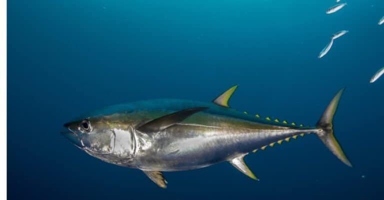
Yellowfin Tuna
Yellow fins, ocean miles

Yellow fins, ocean miles
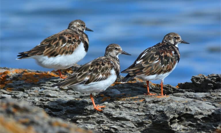
Flip a stone, cross an ocean.
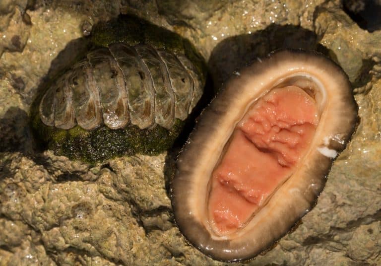
Eight plates. One unstoppable grip.
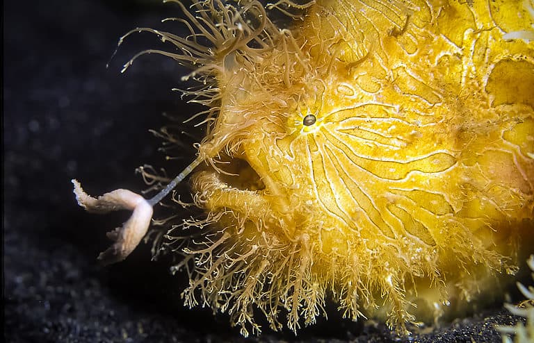
Hairy master of disguise-hook, lure, gulp
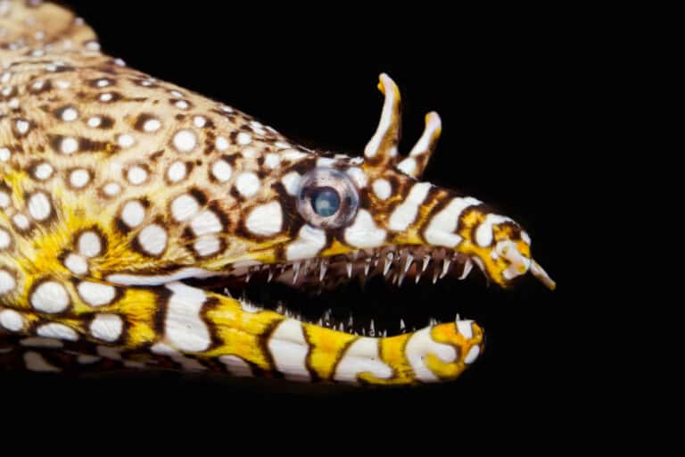
Spots, horns, and fangs after dark
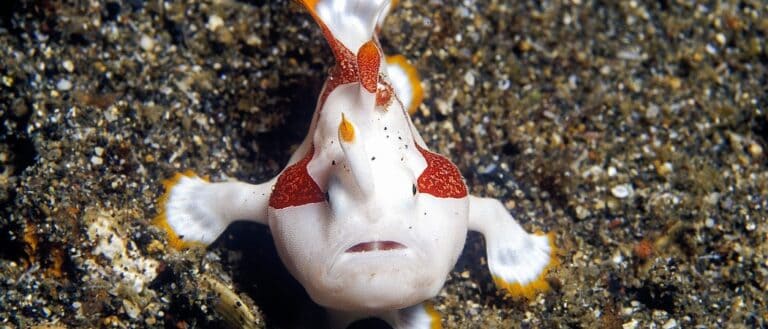
Walk, vanish, lure, gulp.
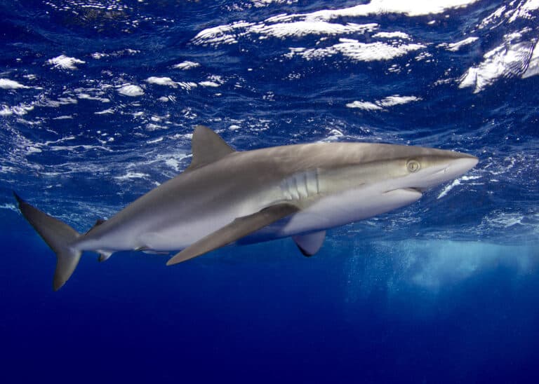
Silky: the sleek shadow of tuna seas
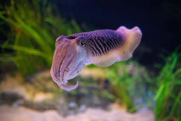
Camouflage geniuses with built-in buoyancy
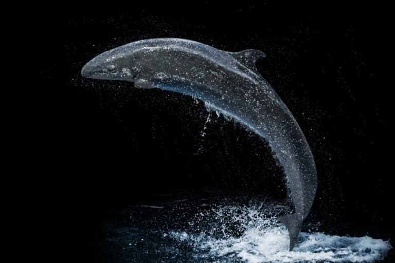
Big dolphin. Tight bonds. Team hunter.
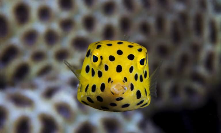
Built like a box, swims like a drone
The South China Sea is a large marginal sea of the western Pacific Ocean situated between southern China and the nations of Southeast Asia, connecting to adjacent seas and straits and spanning broad continental shelves, deep basins, and reef-dotted archipelagos.
The South China Sea forms one of the Western Pacific's major semi-enclosed basins, framed by the coasts of southern China and Taiwan to the north, Vietnam to the west, and the Philippines, Borneo (Malaysia/Brunei), and the Indonesian archipelago to the east and south. Its seafloor includes wide continental shelves (especially along the Sunda Shelf), steep continental slopes, deep central basins, and scattered island and reef systems such as the Spratly and Paracel groups.
Ecologically, it is a tropical-to-subtropical seascape where monsoon-driven circulation, river inputs, and shelf-basin exchanges shape highly productive waters. Extensive coral reefs, seagrass meadows, mangrove-lined coasts, and soft-sediment shelf habitats support rich biodiversity and important nursery grounds for fish and invertebrates.
The sea is also one of the world's most economically and strategically significant marine regions, underpinning major continental shelf fisheries and aquaculture-linked coastal economies, while hosting heavily used shipping routes that connect East Asia with the Indian Ocean and beyond.
Etymology: South China Sea is a geographic directional name used in European cartography, referring to the sea lying south of China; the Chinese name literally means 'South Sea' and is one of the traditional 'Four Seas' in Chinese geographic nomenclature.
Coral reef hotspots (Spratly & Paracel Islands), productive shelf fisheries, one of the world's busiest shipping corridors, and major geopolitical/maritime disputes
The South China Sea is a large tropical-subtropical marginal sea in the western Pacific Ocean. It lies south of mainland China and Taiwan, east of Vietnam and the Indochina Peninsula, north of Borneo (Malaysia/Brunei/Indonesia), and west of the Philippines, forming a central marine corridor for Southeast Asia.
Deep South China Sea Basin (central basin, roughly west of Luzon and northwest of Palawan)
Northern margin (Guangdong/Guangxi coast) and Hainan Island; major river-influenced shelves and fisheries.
Northeastern boundary influence via Taiwan and adjacent straits (political status disputed).
Western boundary; broad continental shelf and productive upwelling/monsoon-driven fisheries.
Eastern boundary (Luzon and Palawan); passages connect to the open Pacific and adjacent basins.
Southern/southeastern boundary (Sabah and Sarawak on Borneo) plus parts of the Sunda Shelf margin.
Small coastline on northern Borneo fronting the southern South China Sea shelf.
Southern fringe (including waters around the Natuna Islands) on the Sunda Shelf transition.
Via the Gulf of Thailand, which opens into the southwestern South China Sea.
Short coastline within the Gulf of Thailand system connected to the South China Sea.
North: southern China (including Hainan) and the Taiwan Strait/Taiwan; West: Vietnam and the Gulf of Thailand/Indochina coasts; East: the Philippines (Luzon and Palawan) and the Luzon Strait approaches; South: Borneo and the Sunda Shelf region (northern Indonesia and East Malaysia).
Surface avg: ~27-29°C annual mean (higher in the southern tropics, lower in the northern/northwestern shelves in winter)
Deep avg: ~2-4°C in the deep basin below ~1000-1500 m
Typical open-sea surface salinity ~32-34.5 PSU; fresher near major river plumes (e.g., Pearl River, Mekong) and during rainy/monsoon periods; higher salinity intrusions occur with Kuroshio inflow through Luzon Strait and during dry seasons.
Monsoon-driven seasonality: warmer, strongly stratified surface layer in boreal summer (May-Sep); cooler surface waters and deeper mixed layer in boreal winter (Nov-Mar), especially in the north and on shelves.
Monsoon-reversing circulation dominates: a basin-scale cyclonic gyre in winter (northeast monsoon) with strong southwestward coastal currents along China/Vietnam; and an anticyclonic tendency or gyre reorganization in summer (southwest monsoon), including northward flow along Vietnam and eastward/northeastward components in the southern basin. Key current systems include (1) Kuroshio intrusion/looping through Luzon Strait feeding the northeastern SCS, (2) Vietnam coastal current system (seasonally reversing), (3) shelf currents on the Sunda Shelf with strong throughflow/connection toward the Java Sea, and (4) mesoscale eddies (frequent) that modulate transport and productivity.
Predominantly mixed (diurnal-semidiurnal) with strong spatial contrasts: larger tidal ranges and energetic tidal currents on shelves and in straits (e.g., Taiwan Strait, Luzon Strait approaches, and narrow passages around the Sunda Shelf), and generally smaller ranges offshore in the deep basin. Internal tides are prominent, especially generated near Luzon Strait and other steep topography, propagating into the basin.
A tropical-subtropical marginal-sea mix influenced by (a) warm, relatively saline Pacific-derived waters entering via Luzon Strait (Kuroshio-related), (b) fresher, warm surface waters from monsoonal rainfall and river discharge, and (c) cooler, saltier intermediate/deep waters formed through mixing and exchange with the western Pacific. Distinct shelf waters occur on the Sunda Shelf (warmer, often fresher and more turbid), while the deep basin is characterized by comparatively uniform, cold, well-oxygenated deep water with renewal linked to overflow/ventilation through Luzon Strait.
Strong thermocline and halocline most of the year, intensified in summer by surface heating and freshwater inputs; winter monsoon winds deepen the mixed layer and can erode stratification in the north and on shelves. A pronounced seasonal mixed-layer depth cycle occurs (shallow in summer, deeper in winter), with frequent mesoscale eddy-induced doming/depression of isotherms/isohalines.
Major nutrient upwelling occurs along the central-southern Vietnam coast during the southwest monsoon (Jun-Sep), driven by alongshore winds and Ekman transport, often extending offshore via jets/eddies. Additional localized upwelling/mixing hotspots occur near straits and topographic features (e.g., Luzon Strait internal-wave/tidal mixing; shelf breaks off Guangdong/Hainan under favorable winds) and on parts of the Sunda Shelf margin where monsoon winds and currents enhance vertical exchange.
Highly monsoon-controlled physics and biogeochemistry; frequent tropical cyclones/typhoons that trigger short-lived strong mixing, cooling, and phytoplankton blooms; pervasive mesoscale eddies influencing heat/salt transport and fisheries productivity; strong internal waves/internal tides (notably from Luzon Strait) causing intense localized mixing; large river-plume buoyancy fronts (Pearl River, Mekong) creating sharp salinity gradients and coastal hypoxia risk in eutrophic/stratified areas; seasonal coral-reef heat stress/bleaching risk during anomalously warm summers and marine heatwaves.
The South China Sea has a tropical to subtropical monsoon-driven marine climate with warm sea surface temperatures year-round, high humidity, and strong seasonal shifts in winds and rainfall. Conditions range from consistently tropical in the south to more seasonally variable (cooler, drier winters) in the north. Productivity is shaped by monsoon winds, coastal upwelling (notably off Vietnam in summer), river inputs, and broad continental shelves that support major fisheries alongside coral reef and seagrass ecosystems.
Winter (Nov-Mar): Northeast monsoon dominates, bringing stronger northeasterly winds, rougher seas, and generally drier, cooler conditions-especially in the northern basin; surface waters can cool noticeably in the north while remaining warm in the south. Summer (May-Sep): Southwest monsoon brings warmer, more humid conditions, frequent convective rain, and enhanced mixing; summer winds can drive coastal upwelling and higher nutrient availability along parts of the western boundary (e.g., off central/southern Vietnam). Transition periods (Apr and Oct): Variable winds, calmer seas on average, and periods of intense thunderstorms as the monsoon reverses; these shoulder seasons often feature rapid shifts in weather and localized heavy rainfall.
Tropical cyclones (typhoons and tropical storms) affect the basin mainly from late spring through autumn, with peak activity typically in late summer to early fall. Tracks commonly enter from the western Pacific via the Luzon Strait or form locally, then move westward/northwestward toward the Philippines, southern China (including Hainan/Guangdong), Vietnam, and occasionally the Gulf of Thailand. Impacts include short-lived but extreme winds and waves, coastal storm surge, and very heavy rainfall; risk is generally higher in the northern and central parts of the sea during peak season, though damaging storms can occur across the basin.
No sea ice forms in the South China Sea under present-day climate; ice conditions are not a factor for this marine zone.
The South China Sea is a tropical-subtropical, monsoon-driven marginal sea with strong seasonal winds, shifting currents, and major river inputs (e.g., Mekong and Pearl). Its ecology spans clear-water offshore reef systems (including isolated atolls and platform reefs), broad continental shelves with high fishery productivity, and turbid nearshore zones influenced by sediment and nutrients. Biodiversity is highest around coral reefs, seagrass-mangrove mosaics, and island chains, while productivity peaks on shelves, in upwelling areas (notably off central Vietnam), and along frontal zones that aggregate plankton and pelagic predators.
High tropical marine diversity shaped by Indo-West Pacific species exchange, extensive reef habitat in the Spratly/Paracel regions, and large areas of productive shelf and coastal wetlands. Diversity is uneven: reef and island habitats are very species-rich, while heavily impacted nearshore areas can be locally depleted. Regional connectivity means true basin-wide endemism is relatively limited compared with isolated archipelagos.
Species count: Tens of thousands of described marine species region-wide; commonly cited components include ~500+ reef-building coral species and roughly ~2,500-3,000 reef-associated fish species (with totals varying by subregion and survey effort).
The South China Sea neritic zone spans broad continental shelves and coastal embayments from southern China to Vietnam, Malaysia, Brunei, the Philippines, and Borneo. Warm, seasonally monsoon-driven waters mix with river outflows (e.g., Mekong, Pearl River), creating strong gradients in salinity, turbidity, and nutrients. Shallow habitats include coral reefs, seagrass meadows, mangrove-fringed lagoons, sandy beaches, and muddy estuaries that function as nurseries for reef fish, prawns, crabs, and small pelagics. Seasonal upwelling (notably off central Vietnam and parts of the Sunda Shelf) and wind-driven mixing boost plankton production and sustain some of the region's most important shelf fisheries, while typhoons and monsoon transitions periodically reset coastal communities via disturbance and sediment pulses.
The pelagic zone of the South China Sea is the open-water environment over deep basins, dominated by warm surface waters, a pronounced thermocline, and monsoon-driven circulation that shifts seasonally. Primary production is generally oligotrophic offshore, but rises in localized "hotspots" tied to eddies, fronts, internal waves, and seasonal upwelling-features that aggregate plankton and micronekton. These transient productivity zones support schooling forage fish (e.g., scads, sardines/anchovies where conditions allow), squid, and larger predators such as tunas, billfishes, and pelagic sharks. The deep scattering layer and nighttime vertical migrations of zooplankton and small fishes are central processes, transferring energy from surface production to deeper waters and fueling upper trophic levels.
The benthic zone ranges from shallow reef flats and seagrass sediments to deep-basin muds and slopes. On carbonate platforms and atolls, reef-building corals and coralline algae create complex hard-bottom habitats that support rich invertebrate and fish assemblages; nearby, seagrass beds and mangrove-derived sediments host burrowing bivalves, polychaetes, sea cucumbers, and abundant crustaceans. On continental shelves, soft-bottom communities (worms, clams, shrimps, crabs) dominate and recycle organic matter delivered from the water column and rivers. In deeper areas, low-light, low-food conditions favor slower-growing fauna (deposit feeders and scavengers) that depend on detritus "marine snow," occasional carcass falls, and episodic pulses of productivity exported from surface waters.
The demersal zone-waters just above the seabed and around reef structures-links bottom habitats to the wider water column. Along shelf edges, reef slopes, and soft-bottom plains, demersal assemblages include snappers, groupers, emperors, flatfishes, lizardfishes, croakers, threadfin breams, and cephalopods, many of which feed on benthic invertebrates and small fishes. These communities are strongly shaped by habitat complexity (reefs vs. sand/mud), oxygen and turbidity near the bottom, and monsoon-season changes in currents that influence larval delivery and prey availability. Nighttime foraging and crepuscular activity are common, with predators patrolling reef margins and soft-bottom ecotones where prey concentrate.
Seasonality is driven mainly by the Northeast (roughly boreal winter) and Southwest (roughly boreal summer) monsoons, which shift currents, productivity, and animal distributions. Many commercially important small pelagics and neritic fishes track plankton-rich waters and upwelling zones, producing seasonal fishing peaks on shelves and along current fronts. Highly migratory species such as tunas and billfishes move through the basin and along shelf edges in response to temperature structure, prey (squid/forage fish), and eddy/front activity; movements often intensify around monsoon transitions when productivity and aggregation features strengthen. Marine turtles and some seabirds also show seasonal movements between foraging areas on productive shelves and nesting or roosting sites across surrounding coasts and islands.
Key food webs begin with (1) phytoplankton-based chains in shelf and upwelling areas: phytoplankton → zooplankton → anchovies/sardines/scads and juvenile fishes → mackerels, tunas, seabirds, dolphins, and sharks. (2) Reef and seagrass pathways: benthic algae/seagrass and reef-associated plankton → herbivorous fishes (parrotfish, rabbitfish), grazers (urchins), and filter feeders → mesopredators (snappers, groupers) → apex predators (reef sharks, large groupers). (3) Detrital/estuarine-mangrove webs: mangrove leaf litter and particulate organic matter → microbes and detritivores (crabs, shrimps, polychaetes) → estuarine and coastal fishes → larger coastal predators and demersal fisheries species. Cross-linkages are strong: nocturnal vertical migrations move pelagic energy downward, while reef and shelf habitats export larvae and biomass to open waters, supporting the region's high biodiversity and fisheries productivity.
The South China Sea supports globally significant coral reefs, seagrass meadows, mangroves, and highly productive continental-shelf fisheries, but many habitats are degraded or fragmented. Regional biodiversity remains high, yet ecosystem condition is widely stressed by intensive fishing pressure, coastal development and land reclamation, sedimentation, and escalating climate-driven coral bleaching. Management capacity and enforcement vary by country, and governance is complicated by overlapping maritime claims and high shipping intensity.
Stressed and degraded in many areas; pockets of high biodiversity remain but are under heavy pressure.
High fishing effort (including IUU fishing) and destructive practices in some areas have reduced biomass, altered food webs, and increased bycatch of protected species (e.g., sharks, rays, turtles).
Land-based runoff (nutrients, sediments, pesticides), untreated sewage, plastics/marine debris, and oil/chemical contamination from ports and shipping lanes degrade coastal waters and reefs.
Coastal reclamation, port/industrial expansion, dredging, and reef damage reduce coral, seagrass, and mangrove extent and connectivity, with long recovery times.
Land reclamation, artificial island construction, navigation-channel dredging, and shoreline hardening directly damage benthic habitats and increase turbidity/sedimentation.
Rising sea temperatures drive mass coral bleaching and mortality; ocean acidification and marine heatwaves reduce calcification and resilience; sea-level rise increases coastal erosion and salinity stress in wetlands.
Altered river flows and coastal hydrology (dams, drainage, shoreline engineering) change sediment/nutrient delivery, impacting mangroves, deltas, seagrass, and nearshore reefs.
Intense vessel traffic, tourism, anchoring, and noise disturb wildlife and physically damage reefs; chronic disturbance can reduce breeding and feeding success for sensitive species.
Coral disease outbreaks and stress-related syndromes increase after heat stress and pollution exposure, compounding bleaching impacts.
Localized issues (e.g., introductions via ballast water, hull fouling, and aquaculture escapes) can affect native communities, though impacts are currently less documented than other pressures.
Major inputs include nutrient and sediment runoff from agriculture and urban areas, untreated/partially treated sewage in some coastal zones, high plastic leakage, and chronic oil/chemical risks along major shipping routes and near ports.
Many stocks are heavily exploited, with reduced average fish size and biomass; IUU fishing and some destructive methods persist despite regulations, increasing bycatch and habitat damage.
Frequent marine heatwaves and warming elevate coral bleaching risk and mortality; acidification reduces reef-building capacity; stronger storms and sea-level rise increase physical damage and coastal habitat stress.
Risk pathways include ballast water, hull fouling, and aquaculture; impacts are generally localized/underreported relative to fishing and development pressures.
A vast archipelago of small islands, reefs, and cays scattered across the central South China Sea.
One of the region's richest coral reef areas and among the most geopolitically contested maritime zones; supports reef fish, seabirds, and turtle habitats alongside major fishing grounds.
A group of islands and reefs in the northwestern South China Sea, including wooded islets and surrounding reef flats.
Notable for extensive coral reefs and productive surrounding waters; strategically located and central to maritime boundary disputes and regional navigation routes.
A triangular chain of reefs enclosing a lagoon, located west of Luzon in the northeastern South China Sea.
Important traditional fishing area and coral reef habitat; internationally prominent due to high-profile sovereignty and access disputes.
A broad, shallow undersea bank/shoal area on the Sunda Shelf west of Palawan, with reef-like features and sandy-muddy seabed areas.
Ecologically significant shelf feature supporting fisheries; also notable for hydrocarbon exploration interest and overlapping maritime claims.
A large, mostly submerged atoll-like bank and reef complex in the central-northern South China Sea.
One of the largest submerged reef systems in the region, influencing local oceanography and serving as important habitat for reef-associated species.
A near-circular coral atoll with a central lagoon in the northern South China Sea.
A classic atoll ecosystem with high coral and seagrass value; recognized for conservation importance and as a relatively intact reef-lagoon system compared with many heavily impacted reefs.
A massive reef complex off Mindoro, Philippines, with shallow coral gardens, drop-offs, and sandy channels.
Among the largest coral reef systems in the Philippines and a major biodiversity hotspot; popular for diving and critical for fisheries replenishment within its protected zones.
A coastal bay in Vietnam with nearby islands and reef patches, including the Hon Mun protected area.
One of Vietnam's best-known reef and dive regions; an early and prominent MPA model in the country focusing on coral reef conservation and sustainable tourism.
A cluster of islands off Sabah, Malaysian Borneo, with fringing reefs, sandy beaches, and nearshore seagrass areas.
High-use, accessible marine park supporting reef conservation, recreation, and environmental education; showcases nearshore coral communities in the Coral Triangle-adjacent region.
A strait between Palawan (Philippines) and northern Borneo, connecting the South China Sea to the Sulu Sea.
Ecologically important corridor for marine life exchange between seas and a key navigation passage; nearby waters host seagrass and mangrove-associated fisheries.
A large shallow gulf bordered by Thailand, Cambodia, and Vietnam, with extensive soft-bottom habitats and coastal wetlands.
Major regional fishery and nursery area shaped by river inputs and monsoons; notable for seagrass beds, coastal productivity, and heavy human use pressures.
The South China Sea has long been a core maritime crossroads linking China, Mainland Southeast Asia, the Malay Peninsula, and the Indonesian archipelago, forming a key segment of the broader Maritime Silk Road. From at least the first millennium CE, merchants moved ceramics, silk, metals, spices, aromatic woods, resins, and later tea and textiles through seasonal monsoon navigation. Major historical polities and port cities around its rim-including Chinese dynasties' southern ports, Champa and Đại Việt along the Vietnam coast, Khmer-linked entrepôts, the sultanates of the Malay world, and Philippine coastal trading networks-were shaped by this sea-based commerce. European expansion in the 16th-19th centuries (Portuguese, Spanish, Dutch, British, French) intensified mapping, naval exploration, missionary activity, and colonial trade, leaving a dense legacy of charts, shipwrecks, and coastal fortifications. The area also preserves significant underwater cultural heritage (wrecks from Chinese, Southeast Asian, and European trade), reflecting centuries of long-distance exchange and regional maritime connectivity.
One of the world's busiest shipping regions, the South China Sea connects the Indian Ocean and the Pacific via the Malacca Strait and onward through major corridors toward East Asian industrial hubs. Primary shipping lanes run from Singapore through the southern South China Sea to the Taiwan Strait and the Luzon Strait, with heavy traffic converging off Vietnam's coast and along routes to/from Hong Kong-Shenzhen-Guangzhou, Xiamen/Fuzhou, and the Yangtze River Delta via adjacent seas. Major and high-throughput ports tied to South China Sea trade include Singapore (southern gateway), Port Klang and Tanjung Pelepas (Malaysia), Ho Chi Minh City/Cát Lái and Hải Phòng-Lạch Huyện (Vietnam), Laem Chabang and Bangkok (Thailand, via Gulf of Thailand), Manila and Subic (Philippines), Brunei's Muara, and China's southern mega-ports (Hong Kong, Shenzhen/Yantian, Guangzhou/Nansha, Zhuhai, Xiamen). Cargo types include containerized manufactured goods, energy shipments (LNG, crude, refined products), bulk commodities, and regional feeder traffic among ASEAN ports.
Industrial and semi-industrial fleets operate widely across continental shelves and slopes, targeting small pelagics, tuna-like species, demersal fishes, and invertebrates using purse seines, trawls, gillnets, longlines, and lift nets. Landings supply large domestic markets and export chains (frozen, canned, dried/salted), with intense effort near productive shelf areas (e.g., off Vietnam, the Gulf of Tonkin approaches, the Sunda Shelf margins, and waters around reef complexes). The sector is economically critical but associated with overcapacity in parts of the region, localized depletion of demersal stocks, bycatch concerns, and periodic disputes over access and enforcement in contested waters.
Coastal and small-island communities depend on nearshore reefs, seagrass beds, mangroves, and lagoons for daily protein and income. Artisanal gears include hook-and-line, handlines, small gillnets, fish traps, spear fishing, gleaning for shellfish, and small lift nets. Many communities combine fishing with small-scale aquaculture (e.g., seaweed farming, bivalves) and seasonal work, and are highly sensitive to habitat loss, storm impacts, and changing fish distributions.
Generally tropical to subtropical conditions with warm water year-round in the south, seasonal cooling in the north, and visibility that ranges from excellent at offshore reefs and islands to more limited near sediment-rich coasts and estuaries. Monsoon seasons strongly shape sea state, currents, and safety windows: northeast monsoon (rougher in many northern/central areas) and southwest monsoon (rougher in many southern/western-exposed areas). Coral reef health is variable; divers may encounter vibrant reefscapes in some protected/offshore zones and degraded reefs near heavy coastal use. Currents can be strong at channels and pinnacles; typhoons affect the northern sector seasonally.
Tourism concentrates on warm-water beaches, island-hopping, marine parks, and cultural coastal cities. Key activities include snorkeling and reef-watching, sailing and yachting, sea kayaking, sportfishing, seafood tourism, and visits to coastal heritage sites. Notable destination clusters include Vietnam's Hạ Long Bay and islands off central/southern Vietnam; China's Hainan (Sanya) and nearby coastal resort belts; the Philippines' Palawan corridor (including the west-facing island chain) and other South China Sea-facing islands; Malaysia's east coast/island resorts (e.g., Tioman and adjacent areas) and Sabah's offshore islands; and Brunei's coastal tourism. Ecotourism and marine protected areas are significant in some locales, though coral bleaching, coastal development, and pollution can affect visitor experiences.
The South China Sea hosts extensive offshore oil and gas exploration and production, especially along continental shelf margins and in proven basins. Activities include seismic surveys, drilling, platform/rig operations, subsea pipelines, and supply-vessel logistics. Major producing and exploration areas occur off Vietnam's southern shelf, offshore Sarawak and Sabah (Malaysia), Brunei's offshore fields, parts of the Gulf of Thailand's connected petroleum province, and China's offshore zones near Hainan and the Pearl River Mouth Basin. These activities are economically significant but can be complicated by overlapping maritime claims, environmental risk management (spills, routine discharges), and conflicts with fishing grounds.
Strategically pivotal for regional and global security due to its role as a maritime chokepoint-adjacent corridor (linking the Malacca Strait to the Western Pacific), proximity to major coastal population/industrial centers, and concentration of contested features and claims. Multiple states maintain naval, coast guard, and maritime militia/paramilitary patrols, surveillance infrastructure, and logistics capabilities across the region, with periodic exercises and presence operations by extra-regional navies to assert navigation rights and protect sea lines of communication. The sea's contested islands/reefs and associated air/sea control considerations amplify its importance for deterrence, crisis management, and regional balance of power.
The South China Sea borders a mosaic of coastal and island societies with long maritime traditions. Along southern China and Hainan are fishing and seafaring communities tied to Cantonese, Hokkien/Minnan, Teochew/Chaozhou, Hakka, and Hainanese cultural spheres, with historic merchant diasporas throughout Southeast Asia. Vietnam's coast includes Kinh/Viet communities and notable maritime legacies of Cham (Champa) culture in central Vietnam. The Philippines' west-facing islands host diverse Austronesian-speaking coastal groups with strong boatbuilding and reef-based livelihoods, alongside broader Tagalog, Visayan, and other regional cultures. Malaysia and Brunei include Malay coastal cultures and, in Sabah, Indigenous maritime-oriented peoples such as Bajau/Sama (often associated with mobile seafaring traditions) and other coastal Indigenous communities. Across the region, sea-centered practices-monsoon navigation knowledge, artisanal fishing, reef and mangrove stewardship, seafood cuisines, and coastal ritual calendars-remain important, though increasingly pressured by urbanization, industrial fishing, and environmental change.
227 species documented in our encyclopedia
Thank you for reading! Have some feedback for us?
We appreciate your help in improving our content.
Our editorial team will review your suggestions and make any necessary updates.
There was an error submitting your feedback. Please try again.