Ortolan Bunting
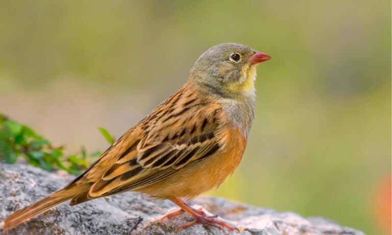
Long-haul bunting of open fields
Long-haul bunting of open fields

Booming monarch of the night cliffs
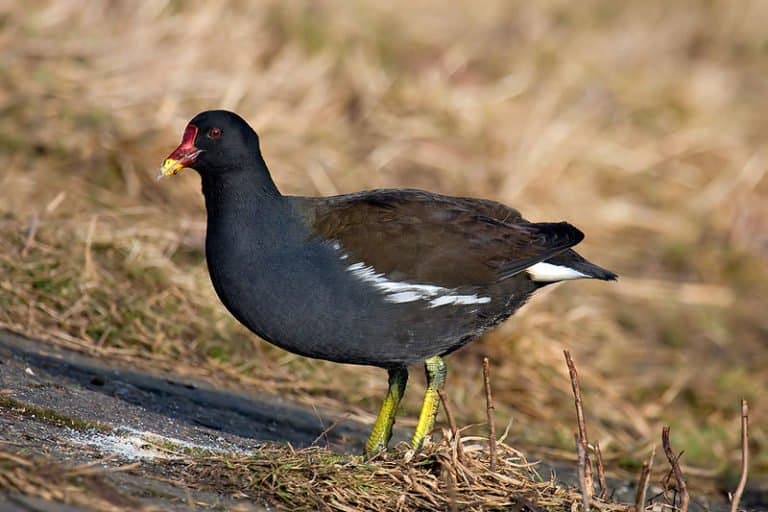
The reed-bed runner on lily pads
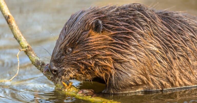
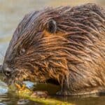
Nature's wetland engineer
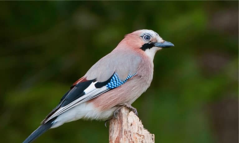
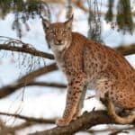
Oak Forest Planter with a Blue Flash
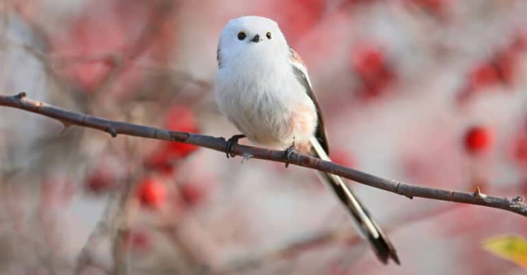
Long tail, tight flock, big personality
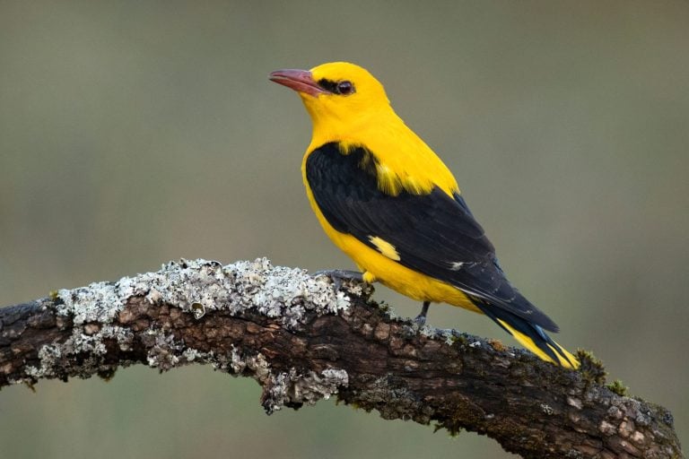
Golden voice in the green canopy
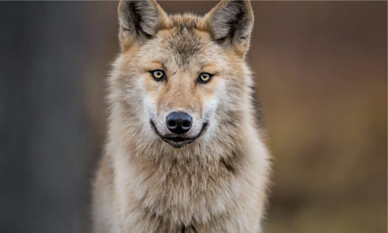
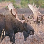
Wild Europe's original pack hunter
Bashkortostan lies in the southern Urals, where European broadleaf-and-conifer forests meet open forest-steppe and true steppe. This meeting of biomes, plus rugged Ural ridges, creates many kinds of habitats and many kinds of animals: large ungulates (hooved animals) and carnivores in wooded uplands, grassland specialists on the plains, and many river and wetland species along major valleys. Key ecosystems include mountain taiga and mixed forests; steppe and forest-steppe mosaics; and the Ufa-Belaya river network with floodplain meadows, oxbows, and wetlands that draw birds and mammals. Limestone massifs and karst add cliffs, caves, and cool ravines that shelter special plants and bats. Compared with nearby lands that are mostly taiga to the north or open steppe to the south, Bashkortostan’s short gradient from mountains to plains gives a compact, varied wildlife experience.
Bashkortostan lies at the Europe-Asia edge in the southern Urals. Mountain ridges, foothills, and wide river basins create big changes in climate, soil, and plants. This makes a mosaic of taiga/mixed forest, broadleaf forest, forest-steppe, and steppe. Rivers (especially the Belaya-Ufa) and karst areas add riparian, wetland, and cave habitats that boost biodiversity and migration routes.
Approximately ~80 m in major river lowlands to 1,640 m at Mount Yamantau (Southern Urals)
Designated 1992
Bashkortostan lies in the Southern Urals between Europe and Asia, covering dark conifer, mixed and broadleaf forests, forest-steppe, steppe, and rivers like the Belaya River and Ufa River. Federal nature reserves and a national park protect mountain taiga, karst areas, and river valleys. Regional parks, wildlife refuges, and nature monuments protect lakes, gorges, spawning sites, and rare species.
≈8-10% of the republic's land area under some form of protection (strict + regional categories; approximate, varies by classification).
Large forest-and-river protected landscape in the Southern Urals, noted for intact riparian corridors and mixed taiga/broadleaf habitats that support healthy populations of large mammals and forest birds; also valued for scenic river canyons and karst features.
One of the most important roadless mountain-taiga blocks in the Southern Urals, protecting high ridges, old-growth conifer forests, bogs, and headwaters-excellent for conserving wide-ranging carnivores and sensitive forest grouse communities.
Strictly protected forest reserve safeguarding representative Southern Ural mountain forests and biodiversity; valuable as a refuge for large mammals and forest raptors and as a benchmark site for long-term ecological monitoring.
Internationally known for its karst landscapes and cave systems (incl. Kapova/Shulgan-Tash Cave area) and for conserving old forests and river valleys; also notable for traditional wild-honey (tree-beekeeping) landscapes tied to native forest ecosystems.
Protects the Iremel massif with mountain tundra-like communities, subalpine meadows, and dark conifer forests; a stronghold for upland fauna and an important climate-refugia landscape.
A biodiversity-rich river gorge and karst/cave landscape that concentrates raptors, cave-dwelling bats, and riverine mammals; notable for cliffs, caves, and mosaic habitats along the valley.
Large lake-and-wetland complex important for waterbirds during migration and breeding; one of the best wildlife-viewing areas for wetland birds in the forest-steppe zone.
Steppe-edge lake, reedbeds, and surrounding open habitats supporting rich waterfowl and shorebird assemblages; valued for protecting wetland biodiversity in an otherwise agricultural landscape.
A complex (multi-purpose) state nature sanctuary in the Republic of Bashkortostan associated with the Shulgan-Tash (Burzyansky) forest-karst landscape and traditional wild-honey beekeeping area; established to protect forest and river-valley ecosystems and their wildlife.
Protected river corridor and surrounding forested slopes that function as a migration route and breeding habitat for forest birds and riparian mammals; important for maintaining connectivity between larger mountain protected areas.
Refuge covering high-ridge forests and uplands that support wide-ranging mammals and sensitive forest grouse; valued for protecting relatively undisturbed ridge-top habitats and watersheds.
Bashkortostan sits at the Europe-Asia crossroads of the Southern Urals, combining dark conifer-broadleaf mountain forests, forest-steppe, and true steppe, all threaded by major rivers (Belaya/Agidel, Ufa, Nugush and tributaries). This landscape mosaic supports a classic temperate-Ural fauna: large forest mammals (bear, moose, lynx), rich grouse and raptor communities, and diverse riverine wetlands with notable migratory birds and valuable native fish (including sturgeon relatives). Protected areas in the Southern Urals (e.g., mountainous reserves and national parks) are especially important refuges for forest and cliff-nesting species.


Bashkortostan in the southern Urals offers varied wildlife: conifer and mixed mountain forests, broadleaf woodland and forest-steppe lowlands, open steppe and rivers (Belaya and Ufa). Track elk, roe deer and wild boar (brown bear rarer), and watch raptors, grouse, owls and migrating cranes. Protected areas like Bashkiria National Park and Shulgan-Tash reserve support ethical, habitat-focused viewing.
Peak bird activity as migrants return: raptors over ridgelines, songbirds in mixed forests, waterfowl on thawing rivers and lakes. Forest edges and river valleys are productive for roe deer and elk sign. Expect variable weather (late snow possible in April) and muddy trails-great for track-finding but plan waterproof gear.
Best all-around season for multi-day itineraries: long daylight, stable access to parks, river corridors, and cave areas. Strong chances for mammals at dawn/dusk in forest-steppe clearings; rich insect life brings swifts, swallows, and bats in the evenings. This is also prime time for guided visits to Shulgan-Tash (wild-honey and forest ecology) and scenic river-based trips that combine viewing with paddling/rafting.
Most photogenic season with golden forests and clearer air. Mammals become more visible as vegetation dies back; rut activity increases encounters (keep respectful distance). Excellent raptor passage and mixed flocks during migration; cranes and geese can appear along wetland/river complexes. Nights get cold quickly-pack layers and plan shorter daylight.
Tracking season: fresh snow reveals trails of elk, roe deer, wolf (rare to see but tracks possible), fox, hare, and mustelids. Forest birds (crossbills, tits, woodpeckers) remain active, and owls can be spotted near clearings. Access depends on roads and conditions-guided snowshoe or ski-based outings are most practical and safest.
Bashkortostan lies where the East European Plain meets the Southern Ural Mountains, causing west–east and lowland–upland shifts in climate, soils, and plants. It has mixed and broadleaf forests, forest‑steppe and steppe in the south. The Urals add mountain conifer forests, rocky outcrops, and alpine/subalpine belts. Rivers (Belaya/Agidel, Ufa) and floodplains support rich freshwater and wetland life linking lowlands to headwaters.
Dominant across much of the republic as mixed broadleaf-conifer and deciduous forests on lowlands and foothills; includes linden-oak and birch-aspen stands, with conifers increasing toward higher elevations and cooler slopes in the Urals.
Widespread in the north, west, and Ural foothills; roughly about half of the territory (variable locally).
Forest-steppe and steppe landscapes with feather-grass and forb-rich grasslands, meadow-steppes, and open rolling plains; often interspersed with groves and riparian woods in the forest-steppe belt.
Common in central and especially southern Bashkortostan; roughly ~25-35% overall, concentrated south and southwest.
Taiga-like conifer forests (spruce, fir, pine) in cooler, higher, and more continental parts of the Southern Urals; functions as a montane-taiga belt rather than a broad lowland taiga.
Patchy, mainly along higher elevations and colder slopes in the Urals; ~5-15%.
Subalpine and alpine-like communities on the highest ridges and summits of the Southern Urals, including windswept meadows, tundra-like heaths, and rocky habitats above treeline.
Small, localized at highest elevations (e.g., high ridges); typically <2-3%.
Large river systems (Belaya/Agidel, Ufa, Nugush, Sim, Dema) with headwater streams in the Urals, broad middle reaches, and extensive riparian corridors; includes reservoirs and oxbow lakes.
Present throughout via dense drainage network; highest ecological importance in major valleys and mountain headwaters.
Floodplain marshes, wet meadows, oxbows, peat-forming mires/bogs in depressions and cooler uplands, and wet forested swales along river terraces; key for water purification and breeding birds.
Scattered but frequent in river floodplains and low-lying basins; locally extensive along major rivers.
Large contiguous forest tracts in the north/foothills and extensive mountain forests in the Southern Urals; includes protected areas such as Bashkiria National Park and Shulgan-Tash Reserve.
Linden-oak and mixed broadleaf stands in milder lowlands and foothills; birch-aspen secondary forests are common after disturbance.
Spruce-fir and pine-dominated stands in montane belts and cooler slopes; important for large mammals and watershed protection.
Forest-steppe groves and sparse tree cover on transitions between forest and steppe, often dominated by birch and pine on sandy soils.
Species-rich meadows and steppe grasslands (feather-grass and forb assemblages), including meadow-steppe on well-drained slopes and plains.
True steppe in southern areas with drought-tolerant grasses and forbs; increasingly fragmented by cultivation but still present in patches and reserves.
Shrubby slopes and river-terrace thickets (willow, dogrose, etc.), often as successional vegetation and along ecotones.
Southern Ural ridges and massifs shaping sharp habitat zonation from foothill forests to high-elevation open communities.
Limestone and rocky outcrops with specialized plants and nesting sites for raptors; common in river canyons and mountain valleys.
Karst caves in limestone areas, including the Kapova (Shulgan-Tash) Cave system; important for bats and subterranean fauna.
Major rivers (Belaya/Agidel and Ufa) with braided sections, cutbanks, islands, and riparian forests; critical migration corridors for wildlife.
Natural lakes are less dominant than rivers but occur as floodplain oxbows and karst/tectonic basins; provide fish and waterfowl habitat.
Small ponds and man-made impoundments near settlements and agricultural lands; used by amphibians and waterbirds.
Wet meadows, floodplain wetlands, and peatlands supporting cranes, waders, amphibians, and diverse aquatic plants.
Reed/sedge-dominated marshes in floodplains and around oxbows; seasonally inundated with high productivity.
Peat-accumulating mires in poorly drained depressions and cooler uplands; acidic wetlands with specialized flora.
Extensive croplands and hayfields in the forest-steppe/steppe zones, contributing to habitat fragmentation but also supporting field-edge biodiversity.
Urban/industrial habitats centered on Ufa and other cities, with riverfront modification, parks, and peri-urban green space.
Settlement belts around major cities with mixed gardens, smallholdings, and fragmented woodland/grassland patches.
Bashkortostan's best-known honey tradition isn't just "beekeeping"-it includes maintaining living bee families in high tree hollows (some in old, repeatedly used trees), so the "apiary" can literally be part of the standing forest.
The republic's Europe-Asia position is visible in its fauna: in one trip you can move from steppe and forest-steppe (ground squirrels, steppe birds) into dark conifer and mountain forest where taiga-leaning species (like brown bear and lynx) are regular residents.
Limestone karst areas hold lots of wildlife: caves, sinkholes, many bats, cliff-nesting birds, and river species in short rugged valleys, especially in the Belaya/Agidel river system and its tributary gorges.
The "honey landscape" is ecological as well as cultural: extensive linden (basswood) forests in the Southern Urals create huge seasonal nectar pulses that can rapidly increase insect activity and, in good flowering years, noticeably reshape where birds and mammals forage.
Several rivers in the Belaya (Agidel) basin still support sensitive, cold-water fish communities typical of cleaner upland systems (e.g., grayling in suitable stretches), which surprises visitors who expect only slow, warm lowland rivers in a forest-steppe republic.
Shulgan-Tash State Nature Reserve in Bashkortostan is Russia's main protected area keeping traditional tree-hollow beekeeping and the Burzyan dark European honey bee (Apis mellifera mellifera) in forest hollows.
Kapova (Shulgan-Tash) Cave holds the Urals' only widely accepted Paleolithic cave paintings-making Bashkortostan the record-holder for the region's most famous Ice Age animal depictions (including mammoth and woolly rhinoceros).
Lake Asly-Kul is the largest natural lake in Bashkortostan, and its reedbeds and open water make it a standout regional "magnet" for migrating waterbirds (ducks, geese, swans) moving along the forest-steppe corridor.
The South Ural State Nature Reserve, in Bashkortostan and Chelyabinsk Oblast, is one of the largest strict reserves in European Russia. It protects a big, intact mountain forest used by brown bears, elk, and Eurasian lynx.
8 species documented in our encyclopedia
Thank you for reading! Have some feedback for us?
We appreciate your help in improving our content.
Our editorial team will review your suggestions and make any necessary updates.
There was an error submitting your feedback. Please try again.