Wildlife of
Ingushetiya
About Ingushetiya
Republic of Ingushetia packs rich nature into a small North Caucasus republic. Steep changes in height—from low river valleys and steppe-like plains to forested foothills and high alpine slopes—create a short, sharp range of habitats. This makes a mix of animals: open-country and river-edge species live alongside mountain and forest specialists, and many use Ingushetia as a passage between the Greater Caucasus highlands. Key habitats include broadleaf forests (oak-hornbeam and beech belts) that shelter deer and forest predators; rocky gorges and subalpine meadows that support cliff-nesting raptors and mountain mammals; and riverine corridors of willows, reeds, and floodplain thickets that gather birds during migration. Narrow valleys and ridges act as a natural funnel for migration and movement, so wildlife can change a lot from year to year.
Geography
Ingushetia is small, running from lowland steppe and river valleys in the north to forested foothills and the Greater Caucasus mountains in the south. The sharp change in climate and height creates many nearby habitat zones: riparian corridors, dry grasslands, broadleaf forests, subalpine/alpine meadows and rocky scree. These support diverse Caucasus wildlife and form a movement corridor.
Elevation Range
≈200 m (northern lowlands/river valleys) to ≈4,400-4,500 m (Greater Caucasus crest peaks in the south), creating strong habitat zonation from steppe and riparian systems to alpine environments
Key Landscapes
Protected Areas
Ingushetia's protected areas are mostly in the mountainous south, notably Dzheyrakhsky District, with deep gorges, alpine and subalpine habitats and forests in the Greater Caucasus corridor. No federal national park exists; protection uses federal reserves such as Erzi, republic reserves like Dzheyrakh-Assa, smaller sanctuaries and monuments, protecting ungulates, large birds of prey and linking to North Ossetia-Alania and Chechnya.
Approximately 20-30% under some form of protection (mostly concentrated in the southern mountain zone; figures vary by which protected-area categories are counted).
National Parks & Preserves
Dzheyrakh-Assa State Historical-Architectural and Natural Museum-Reserve
Approx. 60,000-65,000 ha (c. 600-650 km²)Ingushetia's flagship protected landscape: large, relatively intact mountain habitats (gorges, cliffs, forest belts, and alpine/subalpine meadows) supporting strong raptor diversity and mountain-ungulate conservation; also notable for low human footprint in upper valleys, improving wildlife viewing chances (especially at dawn/dusk).
Erzi State Nature Reserve
About 35,292 ha (about 353 km²)A protected mountain area in Ingushetia conserving forest-to-alpine habitats used by ungulates and large predators, and supporting raptors and other mountain wildlife.
Assa Gorge (upper Assa River valley) protected landscape (within/adjacent to the Dzheyrakh-Assa system)
Linear gorge system; commonly treated as a sub-zone within a larger protected landscape rather than a standalone area (tens of km of valley length).Steep gorge and cliff complexes that concentrate wildlife movement and provide nesting ledges for large raptors; riparian strips and side ravines add habitat diversity and are among the better places to spot soaring birds.
State & Provincial Parks
Myat-Loam / Stolovaya Mountain area (regional protected landscape / natural monument; parts near the Ingushetia border)
Mountain massif; protected footprint varies by designation (typically tens of km²).High-elevation meadow-rock mosaics and ridge winds that support raptor flight corridors; good for scanning for eagles and vultures and for observing mountain passerines in summer.
Armkhi-Targim mountain-forest belt (regional OOPT clusters around key valleys and slopes)
Patchwork of protected plots/monuments; combined areas typically range from a few km² to a few dozen km².Mixed forest and meadow habitats that are important for mammals (especially boar/roe deer) and as seasonal movement routes; also supports diverse woodland birds and raptors hunting along openings.
Wildlife Refuges
Sunzha River floodplain conservation zones (regional/municipal OOPT and protective strips along the Sunzha)
Fragmented river corridor; protection is usually measured in strips/segments rather than one contiguous block.Key lowland habitat complementing the mountain reserves: riparian woods, oxbows, and reedbeds that serve as stopover and breeding areas for waterbirds and other migratory species, and provide shelter for semi-aquatic mammals.
Malgobek steppe and semi-steppe habitat refuges (regional game/wildlife sanctuaries and protected patches)
Typically multiple small-to-medium parcels (from a few km² to tens of km² each).Open-country refuges important for steppe birds and small mammals; helps retain a lowland biodiversity component in a republic where most strict protection is mountain-focused.
Erzi State Nature Sanctuary - core refuge zones
On the order of ~30,000-40,000 ha (c. 300-400 km²), depending on zoningFunctions as a de facto wildlife refuge by restricting disturbance in key breeding/foraging areas for ungulates and raptors and maintaining connectivity between forest belts and alpine zones.
Wilderness Areas
- Upper Assa River gorge and side ravines (cliff-and-scree country with limited road access and strong raptor presence)
- High ridgelines and alpine/subalpine meadows of the southern Dzheyrakhsky District (seasonal ungulate ranges; best remoteness)
- Forest belt roadless pockets above the main valleys in the Dzheyrakh-Armkhi-Targim area (quiet refuges for bear/lynx and woodland birds)
- Remote headwaters and tributary valleys feeding the Assa system (low settlement density; important for connectivity and denning sites)
Wildlife
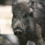
Ingushetia's wildlife reflects the North Caucasus transition from lowland river valleys and steppe-like mosaics to forested foothills and high, rocky alpine belts. The small republic sits on an important Caucasus mountain corridor, so its fauna mixes widespread Eurasian species (wolf, bear, boar, roe deer) with "Caucasus specialties" tied to cliffs, subalpine meadows, and high-elevation forests. Protected areas (notably the Dzheyrakh-Assa region) are key for maintaining viable mountain ungulates, raptors, and near-endemic Caucasus birds and reptiles.
Iconic Species
Endemic & Rare Species
Notable Populations
- High-mountain ungulate assemblages (tur/chamois) in and around protected landscapes of the Dzheyrakh-Assa area, forming an important prey base for large raptors and carnivores.
- Raptor movement along the Greater Caucasus ridgeline and adjacent valleys (golden eagle and migrating eagles/falcons), highlighting the republic's role as a regional flyway corridor.
- Near-endemic Caucasus highland birds (notably Caucasian snowcock and Caucasian black grouse) where intact treeline-subalpine habitat mosaics remain.
Recent Changes
- Region-wide North Caucasus trend: expanding presence of golden jackal (Canis aureus) in parts of the broader region; local establishment varies and is still developing in some mountain areas.
- Ongoing pressure-and-recovery dynamics typical of the Caucasus: where enforcement and protected-area management strengthen, mountain ungulates and associated raptors often show localized stabilization or recovery; where poaching/disturbance persist, declines can occur.
- Raptor declines noted at wider scales for some long-distance migrants (e.g., steppe eagle) may reduce passage numbers over time even if local habitats remain suitable.
- Climate and land-use shifts (warmer winters, changing snowpack, vegetation change, and human activity patterns) are expected to gradually shift the elevational use of alpine/treeline habitats, potentially altering distributions of snowcock, grouse, and cold-adapted reptiles; locally documented trends may be site-specific.
Wildlife Viewing
Ingushetia has many habitats: steppe edges, Sunzha river valleys, hills, and high Caucasus gorges near Dzheyrakh-Assa. Look for mountain ungulates (tur, chamois), raptors and vultures, forest mammals (wild boar, roe deer, fox; sometimes bear, wolf, lynx), and strong spring and autumn bird migration. Best by ridge hikes, early river walks, and keeping distance in protected areas like Erzi and Dzheyrakh-Assa.
Best Seasons
Spring (late March-May)
Peak bird activity and migration along foothills and river corridors; raptors display over ridges; wildflowers in lower slopes; mammals become more active after winter. Expect changeable weather and snow lingering at higher elevations-best for birding + lower-to-mid elevation hikes.
Summer (June-August)
Best access to high-mountain trails in Dzheyrakh-Assa and around Erzi; strong chances for mountain ungulates on rocky slopes at dawn/dusk; vultures/eagles riding thermals midday. Heat haze in lowlands-plan early starts and evening sessions; thunderstorms possible in the mountains.
Autumn (September-October)
Clear air and excellent visibility for scanning cliffs for tur/chamois and for photographing raptors; second major migration window for birds; pleasant hiking temperatures and golden foliage in foothills. Rut/activity for some ungulates may increase sightings; nights can be cold.
Winter (November-March)
Snow makes tracking easier (fox, hare, ungulates) and concentrates wildlife at lower elevations; crisp days can be great for spotting eagles and corvids over valleys. Access to high passes may be limited; best for short, guided valley outings and foothill viewpoints.
Top Wildlife Experiences
- Dawn ridge-scan for mountain ungulates (tur/chamois) in the Dzheyrakh-Assa area: hike to open viewpoints above the Assa River gorge and glass rocky slopes at first light.
- Raptor and vulture watching from cliffside panoramas near the tower-settlement landscapes of Dzheyrakh district (look for eagles, kestrels, and large soaring scavengers using thermals).
- Erzi protected-area day hike with a ranger/approved local guide: focus on quiet observation of forest-edge mammals (roe deer, wild boar) and mountain birdlife along less-traveled trails.
- River-walk birding in the Sunzha River valley and tributaries: kingfisher/dipper-type river specialists (where habitat fits), herons in calmer stretches, and mixed flocks during migration in spring/autumn.
- Nightfall wildlife listening/spotting session near foothill forest edges (with a guide): owls, fox activity, and nocturnal soundscapes-keep lights minimal and follow local rules.
- Alpine wildflower + pollinator photography walk (late spring to early summer) on mid-elevation slopes in Dzheyrakh-Assa-combine botany with butterflies and songbirds.
- Winter tracking walk in accessible foothill areas: learn to read tracks and sign in snow/mud for fox, hare, boar, and ungulates; finish with a long, stationary scan for raptors over open valleys.
Wildlife Watching Types
Guided Options
- Erzi protected-area visits with required permissions and ranger accompaniment (best for responsible route choice and minimizing disturbance).
- Local-certified mountain guides in Dzheyrakh district who can tailor early-morning wildlife hikes (ridgeline glassing, safe access, seasonal trail selection).
- Wildlife-photo guiding (small group) focused on dawn/dusk sessions in Dzheyrakh-Assa panoramas and foothill river valleys.
- Birding day trips led by local naturalists/ornithology enthusiasts in river valleys and foothills during spring and autumn migration windows.
- Multi-day trekking itineraries in the Dzheyrakh-Assa area that combine cultural tower-settlement scenery with dedicated wildlife viewing blocks (sunrise/sunset vantage stops).
Ecosystems
Ingushetia spans a sharp north-south gradient from lowland steppe/forest-steppe and cultivated river valleys (Sunzha-Terek basin) to the rugged, high-relief slopes of the Greater Caucasus in the south. This creates a compact but diverse mosaic of riparian corridors, foothill broadleaf forests, subalpine belts, and alpine grasslands/rocky terrain that supports Caucasus biodiversity and serves as a movement corridor between neighboring mountain regions.
Biomes
Lowland steppe and forest-steppe in the northern/central parts, with grassy slopes and herb-rich meadows interspersed with shelterbelts and riparian vegetation; much is converted to cropland and pastures.
Common in lowlands and foothill plains; substantial human-modified coverage.
Foothill-to-mid-montane broadleaf and mixed forests (oak, beech, hornbeam and mixed stands), including ravine forests and north-facing slopes with higher moisture.
Patchy to extensive in foothills and lower mountain belts, especially in the south and along moist valleys.
Subalpine and alpine belts in the southern mountains: alpine grasslands, rocky ridges, scree, and cold-exposed high-elevation habitats above the main forest zone.
Localized to the highest elevations in southern Ingushetia; forms a distinct belt but limited area due to the republic's small size.
River-dominated freshwater systems (notably the Sunzha and mountain tributaries such as the Assa), with fast-flowing mountain streams, springs, and small impoundments/ponds.
Linear network throughout; highest ecological importance along major valleys.
Floodplain wetlands, riparian willow-poplar stands, wet meadows, and marshy oxbows/seasonally waterlogged patches along major rivers and valley bottoms.
Scattered and narrow, concentrated in lowland floodplains and valley bottoms.
Habitats
Steppe/forest-steppe grasslands in the northern plains and lower foothills; heavily used for grazing and haymaking.
Drier open steppe patches on lowland terraces and exposed foothill slopes, often fragmented by agriculture.
A mosaic of foothill and montane forests forming the main natural cover in the southern half of the republic.
Broadleaf stands (oak-hornbeam-beech where conditions allow), especially in foothills, ravines, and mid-elevation slopes.
Open woodland and scrubby tree cover on drier slopes and ecotones between steppe and closed forest.
Shrub-dominated slopes and regenerating areas (including juniper and other montane shrubs), often on disturbed or rocky ground.
Steep Greater Caucasus terrain with strong elevational zonation, providing refugia and migration routes for mountain fauna.
High-elevation summer pastures and alpine grasslands above the forest line, with short growing seasons and high floristic diversity.
Rock faces and escarpments in the southern mountains, offering nesting/denning sites and specialized plant communities.
Local karst/rock shelters and small cave systems in mountainous areas (where limestone outcrops occur), used by bats and other fauna.
Key corridors such as the Sunzha and Assa rivers, supporting riparian forests, gravel bars, and spawning/feeding habitat for aquatic species.
Small ponds and irrigation/reservoir features in lowlands and settlements, important for amphibians and waterbirds where present.
Floodplain wet meadows, marshy backwaters, and seasonally inundated areas along valley bottoms.
Localized reed/sedge marsh patches in low-lying floodplain depressions and along slow-moving river sections.
Croplands and orchards concentrated in lowlands/valleys; a dominant land use shaping steppe and floodplain habitats.
Urban and peri-urban habitats around Magas, Nazran and other towns, including parks, ruderal vegetation and riverbank modification.
Village belts and dispersed settlements with gardens, small fields, and mixed semi-natural edges that can function as secondary habitat corridors.
Ecoregions
Conservation
Primary Threats
- Most habitat loss is concentrated in the lowland/foothill belt where settlements, smallholder agriculture, and road-side development narrow riparian corridors and steppe/grassland remnants. This reduces connectivity between river valleys and mountain foothills, affecting migratory/seasonal movements of ungulates and predators.
- Road improvement and new utility corridors in narrow gorges (Dzheyrakh-Assa area) can fragment cliffs and forest edges, increase wildlife-vehicle collisions, and open previously quiet habitats to intensive access (poaching, off-road traffic, unregulated tourism).
- Overgrazing around villages and summer pastures (subalpine meadows) degrades plant communities, compacts soils, and reduces forage for wild ungulates; it also increases erosion and undermines the prey base that supports large raptors and carnivores.
- Illegal hunting persists for ungulates and carnivores, especially where road access has improved. Even low levels of poaching can have outsized impacts in a small region with limited source populations and where many species are concentrated in a few gorges.
- Depredation on livestock by wolves and occasional conflict with bears in mountain/foothill zones can trigger retaliatory killing, snaring, and pressure to reduce predator presence near grazing areas.
- Unregulated recreation (off-road vehicles, hiking/camping near nesting cliffs, and seasonal tourism tied to cultural sites) can disturb nesting raptors/vultures and displace ungulates from key saltlicks and watering points in summer.
- Solid-waste disposal and localized sewage/runoff issues around settlements can degrade smaller rivers and tributaries (including riparian habitats used as movement corridors). Quarry dust and roadside runoff also affect valley-bottom vegetation patches that are already limited in area.
- Commercial-scale logging is limited compared with larger Caucasus regions, but localized fuelwood cutting and small-scale logging in foothill forests can simplify forest structure, reduce deadwood, and increase landslide/erosion risk on steep slopes.
- Small quarries and extraction of construction materials (stone/gravel) in foothill/mountain zones can directly remove habitat, increase sedimentation in streams, and create new access tracks that facilitate disturbance and poaching.
- Riverbank engineering, channel straightening, and water withdrawals for irrigation in valley areas simplify riparian habitats and reduce shallow, vegetated margins important for birds and small mammals; they also weaken the corridor function between lowlands and foothills.
- Incremental conversion of remaining grassland and riparian buffers to crops and orchards in valley areas reduces habitat heterogeneity and increases pesticide/fertilizer runoff risk into tributaries.
- Growth around the Nazran-Magas agglomeration and transport routes increases land take, night lighting, and barrier effects. Urban expansion also pushes grazing and recreation pressure upslope into remaining natural areas.
- Warmer winters, altered snowpack, and more frequent summer heat/drought episodes can shift subalpine vegetation, reduce water availability in smaller tributaries, and increase fire risk in dry foothill landscapes-changing forage timing for ungulates and breeding conditions for high-elevation birds.
- Along disturbed roadsides and riverbanks, invasive and weedy plants can outcompete native riparian/steppe flora. This is most evident where construction, grazing pressure, and soil disturbance are high, allowing invasives to spread along the valley transport network.
- Disease spillover risk is tied to close contact between domestic livestock and wild ungulates on shared pastures (e.g., brucellosis and other livestock-associated infections). This is a particular concern in compact mountain pasture systems where animals concentrate at limited watering points.
- Demand for raptors and rare birds can incentivize illegal taking of chicks/eggs or trapping along migration routes that pass through the North Caucasus, with enforcement made difficult by rugged terrain and porous access routes.
- In smaller rivers and tributaries, illegal fishing methods and overharvest can depress local fish populations. Because many streams are short and sensitive, localized pressure can rapidly reduce spawning success and aquatic prey available to riparian wildlife.
Did You Know?
Bearded vultures aren't "meat raptors" in the usual sense: up to ~70-90% of their diet can be bone, and they famously crack large bones by dropping them onto rocks-behavior you can witness in the high Caucasus, including Ingushetia's gorge country.
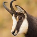
Caucasian chamois (Rupicapra rupicapra caucasica) survive escapes that look impossible because their hooves have a hard rim for grip and a softer center that increases friction-more like a natural climbing shoe than a typical hoof.
In the same small republic, you can encounter wildlife communities that usually belong far apart: river-valley/steppe-edge species in lowlands and true alpine specialists (snowcock, tur, high-mountain raptors) just a short drive away in the Dzheyrakh-Assa highlands.
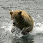
Brown bears in the Central Caucasus (including Ingushetia) are often surprisingly omnivorous-to-plant-leaning for much of the year-feeding heavily on grasses, berries, nuts, and insects when available rather than behaving as constant big-game predators.
Ingushetia's mountain-valley corridor in the Caucasus helps soaring birds (eagles, vultures). They ride updrafts along ridges and gorges to travel with little flapping, seen as circling flight paths.
Ingushetia's high gorges are one of the places in Russia where you can still see the bearded vulture (Gypaetus barbatus): with a wingspan reaching ~2.8-2.9 m, it's among the largest birds of prey in Europe.
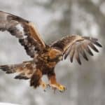
Golden eagles (Aquila chrysaetos) hunting over Ingushetia's mountain slopes belong to one of the world's fastest predator guilds: in a diving stoop, golden eagles have been measured at well over 200 km/h.
The mountain ungulates protected in Ingushetia's highland reserves (notably Caucasian tur and Caucasian chamois) include some of Europe's most cliff-adapted large mammals-built for near-vertical terrain where few other hoofed animals can follow.
Caucasian tur (Capra caucasica / C. cylindricornis complex) are among the largest wild goats in the Greater Caucasus; adult males often weigh 80–100+ kg and have heavy, ridged horns up to about one meter in Ingushetia's alpine zone.