N S W E
Wildlife Expeditions

Wildlife of
Pacific Ocean

The Pacific Ocean is Earth's largest ocean basin, extending from the Arctic Ocean in the north to the Southern Ocean in the south and bounded roughly by Asia and Australia to the west and the Americas to the east.
246 Species
~165.25 million km² Area
10,984 m Max Depth
Overview

Understanding This Category

The Pacific Ocean is Earth's largest ocean basin, extending from the Arctic Ocean in the north to the Southern Ocean in the south and bounded roughly by Asia and Australia to the west and the Americas to the east.

Covering roughly one-third of Earth's surface, the Pacific dominates the planet's oceanic geography and climate influence. It includes immense abyssal plains and deep trenches-most notably the Mariana Trench-and is rimmed by the volcanically active "Ring of Fire," where tectonic plate interactions generate frequent earthquakes, volcanism, and island arcs.

Ecologically, the Pacific spans an extraordinary range of habitats and productivity regimes. Warm, clear tropical waters support coral reefs and atolls across Polynesia, Micronesia, and Melanesia, while cooler mid-latitudes host kelp forests and rich continental shelf ecosystems. In the eastern and equatorial Pacific, wind-driven upwelling fuels some of the world's most productive fisheries, and high-latitude waters in the North Pacific support seasonal blooms and globally significant seabird and marine mammal populations.

The Pacific is also central to global ocean-atmosphere dynamics. The El Niño-Southern Oscillation (ENSO), arising from interactions between trade winds, sea-surface temperatures, and circulation across the tropical Pacific, can shift rainfall patterns, storm tracks, and marine food webs worldwide, underscoring the basin's outsized role in Earth's climate system.

Etymology: The name "Pacific" derives from a Latin term meaning "peaceful" or "calm." It was applied after Ferdinand Magellan encountered relatively tranquil conditions upon entering the ocean from the Strait of Magellan in 1520, in contrast to the often stormier Atlantic routes known to European sailors.

Key Characteristics

Largest ocean by surface area and volume; deepest of the major oceans
Extends from the Arctic to the Southern Ocean, separating Asia/Australia from the Americas
Contains the Mariana Trench and numerous deep-sea trenches associated with subduction zones
Encircled by the Pacific Ring of Fire, with intense tectonic and volcanic activity
Includes highly diverse ecosystems, from tropical coral reefs to temperate kelp forests and subarctic productive waters
Major driver of global climate variability through ENSO and basin-scale circulation patterns
At a Glance

Quick Facts

Type Ocean
Area ~165.25 million km²
Max Depth 10,984 m (Challenger Deep, Mariana Trench)
Temperature Surface ~0-30°C (varies strongly by latitude/season)
Salinity ~34-35 ppt (typical range ~32-37 ppt)
Bordering Countries 40+ countries across Asia, Oceania, North America & South America

Largest and deepest ocean; Ring of Fire volcanoes/earthquakes; El Niño-La Niña; Mariana Trench; major coral reef systems (e.g., Great Barrier Reef)

Physical Features

Geography

The Pacific Ocean lies between Asia and Australia to the west and North and South America to the east, extending from the Arctic Ocean in the north through the tropics to the Southern Ocean in the south. It spans both hemispheres and contains a wide range of climates and marine ecosystems, from coral reef provinces in the western and central Pacific to highly productive upwelling margins along the eastern Pacific.

165.25 million km² Area
~4,280 m Average Depth
~10,935 m Max Depth

Challenger Deep, southern Mariana Trench (western North Pacific)

Major Features

  • Mariana Trench (includes Challenger Deep, deepest known point in the ocean)
  • Tonga-Kermadec Trench system (very deep subduction-zone trenching in the southwest Pacific)
  • Peru-Chile (Atacama) Trench (subduction boundary off western South America)
  • Japan Trench and Kuril-Kamchatka Trench (northwest Pacific subduction margins)
  • Philippine Trench (western Pacific trench system)
  • East Pacific Rise (major mid-ocean ridge and seafloor spreading center)
  • Pacific-Antarctic Ridge (spreading ridge in the far south Pacific sector)
  • Hawaiian-Emperor Seamount Chain (hotspot-related volcanic chain)
  • Ring of Fire (circum-Pacific belt of subduction zones, volcanism, and earthquakes)
  • Clarion-Clipperton Zone (abyssal plain region known for polymetallic nodule fields)

Islands

  • Hawaiian Islands
  • Aleutian Islands
  • Japanese Archipelago
  • Philippine Archipelago
  • Taiwan
  • New Guinea
  • New Zealand (North and South Islands)
  • Mariana Islands (including Guam and the Northern Marianas)
  • Solomon Islands
  • Fiji
  • Samoa
  • Tonga
  • Galápagos Islands
  • Easter Island (Rapa Nui)
  • Society Islands (French Polynesia)

Coastline Countries

Russia

Pacific coast along the Russian Far East (Sea of Japan/Okhotsk and Pacific-facing Kamchatka).

Japan

Extensive Pacific coastline and island arc facing the northwest Pacific.

North Korea

Northeast Asian coastline on the Sea of Japan, part of the Pacific marginal seas system.

South Korea

Coastlines on the Yellow Sea and Sea of Japan, within the Pacific marginal seas.

China

Coastlines on the Yellow Sea, East China Sea, and South China Sea (Pacific marginal seas).

Taiwan

Island with shores on the Philippine Sea/East China Sea, western North Pacific.

Philippines

Archipelago bordering the Philippine Sea and South China Sea, central to the western Pacific.

Vietnam

Coastline along the South China Sea, a major Pacific marginal sea.

Cambodia

Short coastline on the Gulf of Thailand, connected to the South China Sea (Pacific basin).

Thailand

Coastline on the Gulf of Thailand, connected to the South China Sea (Pacific basin).

Malaysia

Coastlines on the South China Sea (Borneo and Peninsular Malaysia).

Singapore

Southern tip of the Malay Peninsula; waters connect to the South China Sea (Pacific basin).

Brunei

Borneo coastline on the South China Sea.

Indonesia

Vast archipelago spanning the western Pacific and key gateways to the Indian Ocean.

Timor Leste

Northern coast on the Banda Sea (within the Pacific-connected Indonesian seas).

Papua New Guinea

Northern Australia region; coasts on the Coral Sea, Bismarck Sea, and Solomon Sea.

Australia

Eastern and northern coasts on the Coral Sea and Tasman Sea (Pacific sector).

New Zealand

Southwest Pacific islands bordered by the Tasman Sea and open Pacific.

United States

Pacific coastline (west coast), Alaska (including Aleutians), Hawaii, and multiple Pacific territories.

Canada

Pacific coastline along British Columbia.

Mexico

Pacific coastline including Baja California and the Gulf of California.

Guatemala

Pacific coastline along Central America.

El Salvador

Pacific coastline along Central America.

Honduras

Small Pacific frontage via the Gulf of Fonseca.

Nicaragua

Pacific coastline along Central America.

Costa Rica

Pacific coastline including gulfs and offshore islands (e.g., Cocos Island).

Panama

Pacific coastline including the Gulf of Panama; canal links to the Atlantic.

Colombia

Pacific coastline on the west of South America.

Ecuador

Pacific coastline; includes the Galápagos Islands in the eastern Pacific.

Peru

Pacific coastline influenced by the Humboldt (Peru) Current upwelling system.

Chile

Long Pacific coastline including fjords and subantarctic waters; includes Easter Island territory.

Fiji

Island nation in the southwest Pacific.

Solomon Islands

Archipelago nation in the southwest Pacific.

Vanuatu

Southwest Pacific archipelago nation.

Samoa

Polynesian island nation in the central South Pacific.

Tonga

Polynesian kingdom bordering deep trench systems in the southwest Pacific.

Kiribati

Widely dispersed atolls/raised islands spanning the central Pacific, near the equator and International Date Line.

Tuvalu

Low-lying atoll nation in the west-central Pacific.

Marshall Islands

Micronesian atoll nation in the central North Pacific.

Micronesia

Federated States of Micronesia, island nation in the western North Pacific.

Palau

Island nation in the western Pacific, near the Philippine Sea.

Nauru

Small island nation in the central Pacific.

France

Borders the Pacific via overseas collectivities (e.g., French Polynesia, New Caledonia, Wallis and Futuna).

United Kingdom

Borders the Pacific via overseas territory (Pitcairn Islands).

Connected Waters

  • Arctic Ocean — Connected at the northern margin via the Bering Strait.
  • Southern Ocean — Directly connected across the southern boundary around ~60°S (circumpolar waters).
  • Indian Ocean — Linked through the Indonesian seas and straits (e.g., Lombok, Makassar, Timor passages).
  • Atlantic Ocean — Connected via the Southern Ocean and the Drake Passage/Cape Horn route.
  • Bering Sea — Major marginal sea on the northern Pacific, opening to the Arctic through the Bering Strait.
  • Sea Of Japan — Marginal sea connected to the northwest Pacific via straits around Japan and Korea.
  • South China Sea — Large marginal sea of the western Pacific, connected through the Luzon Strait and other passages.
  • Coral Sea — Southwest Pacific basin between Australia, Papua New Guinea, and island arcs.
  • Tasman Sea — Southwest Pacific sea between Australia and New Zealand.
  • North Pacific — Sub-basin: the portion of the Pacific north of the equator.
  • South Pacific — Sub-basin: the portion of the Pacific south of the equator.

Boundaries

Bounded by the Arctic Ocean to the north (via the Bering Strait), Asia and Australia to the west, the Americas to the east, and the Southern Ocean to the south. It connects to the Indian Ocean through the maritime passages of Southeast Asia and to the Atlantic Ocean via the Southern Ocean around Cape Horn/Drake Passage.

Physical Characteristics

Oceanography

Temperature Range ~ -1.8 to 31+ °C (polar surface to warm equatorial/nearshore tropics)

Surface avg: ~19 °C (basin-wide surface mean; warmer in the western equatorial Pacific 'warm pool', cooler in eastern boundary/upwelling regions)

Deep avg: ~1.5-2.0 °C (abyssal Pacific; generally slightly warmer and older than North Atlantic deep waters)

Salinity Moderate to high overall; strongly regional

Typical open-ocean surface salinity ~33-35.5 PSU. Higher salinity in subtropical gyres (net evaporation) and parts of the western/central Pacific; lower salinity in the western equatorial Pacific and high-latitude/subarctic regions due to precipitation, river input, and ice melt. Eastern tropical Pacific can be fresher near the ITCZ and coastal runoff zones.

Seasonal Variation

Strong seasonal surface variability at mid-high latitudes (typically ~5-15+ °C swing); weak seasonality in the equatorial belt (often ~1-3 °C). Largest variability occurs in western boundary current regions (Kuroshio/EAC) and in subarctic/subantarctic storm tracks.

Currents

Major systems include: North and South Equatorial Currents (westward), Equatorial Countercurrent (eastward), Kuroshio Current and Oyashio Current with the North Pacific Current/Drift, California Current (eastern boundary), Alaska Current/Stream (subpolar), East Australian Current (western boundary), Peru-Chile (Humboldt) Current (eastern boundary), Antarctic Circumpolar Current influencing the far south, and the Indonesian Throughflow linking the Pacific to the Indian Ocean. The equatorial Pacific is strongly influenced by ENSO-driven changes in trade winds and current strength/position.

Tides

Mixed tidal regimes with strong regional variability. Many central Pacific islands show mixed semidiurnal tides with modest ranges, while some areas (e.g., parts of the Bering Sea, Gulf of Alaska, and certain embayments/estuaries) experience large semidiurnal ranges and strong tidal currents. Amphidromic systems organize tidal phase around the basin; local bathymetry and shelf geometry control extremes.

Water Masses

Surface waters range from warm, low-density tropical waters to cold, nutrient-rich subpolar waters. Intermediate waters include North Pacific Intermediate Water (relatively fresh, formed via mixing/subduction in the Kuroshio-Oyashio region) and Antarctic Intermediate Water spreading northward in the South Pacific. Deep/abyssal waters are largely sourced from the Southern Ocean (Circumpolar Deep Water and Antarctic Bottom Water contributions); North Pacific has limited deep-water formation, so deep waters are older, oxygen-poorer, and nutrient-richer than in the Atlantic.

Stratification

Strong permanent stratification in the tropics and subtropics (warm surface layer over cooler thermocline), typically featuring a shallow mixed layer and a pronounced thermocline/pycnocline. Weaker, more seasonal stratification at mid-high latitudes where winter cooling and storms deepen the mixed layer; subarctic regions can have strong halocline effects in places due to freshwater inputs. Oxygen minimum zones are common in the eastern tropical Pacific at intermediate depths.

Upwelling

Major nutrient upwelling zones include the Peru-Chile (Humboldt) upwelling system, California Current upwelling, equatorial upwelling along the Pacific cold tongue, and seasonal/coastal upwelling around parts of Japan and the Kuril/Kamchatka margins where currents and winds interact. These regions support high primary productivity and major fisheries but can also intensify hypoxia/acidification nearshore.

Unique Conditions

Frequent basin-scale climate variability via ENSO (El Niño/La Niña) alters sea surface temperature, thermocline depth, rainfall, storm tracks, and productivity (especially in the eastern equatorial Pacific). The western Pacific warm pool is among the warmest open-ocean regions on Earth. Extensive oxygen minimum zones and naturally low pH/high CO2 waters occur in the eastern tropical Pacific and in some upwelling margins, increasing vulnerability to acidification and hypoxia events. The Pacific also hosts the planet's deepest trench systems (e.g., Mariana Trench) with extreme-pressure hadal environments and distinctive deep-sea ecosystems.

Weather & Conditions

Climate

The Pacific Ocean spans nearly all climate zones, so conditions range from polar to tropical and strongly reflect global circulation patterns. Tropical regions are warm year-round with high humidity and frequent convection, while temperate and subpolar belts are cooler, windier, and more strongly shaped by mid-latitude westerlies. Major climate controls include the trade winds and subtropical highs, strong western boundary currents (warm Kuroshio/East Australian Current) and eastern boundary currents (cool California/Peru-Humboldt), and large-scale variability such as ENSO (El Niño-Southern Oscillation) that shifts sea-surface temperatures, rainfall, and marine productivity across the basin. Upwelling along the eastern Pacific and equatorial Pacific supports high productivity and cooler near-surface waters compared with the western warm pool.

Seasons

Seasonality varies by latitude. In the tropics, temperature changes are modest but rainfall and wind patterns shift with the seasonal migration of the Intertropical Convergence Zone (ITCZ) and monsoon influences in the western Pacific; many areas have distinct wet/dry seasons. In the North and South Pacific mid-latitudes, winters bring stronger westerlies, larger waves, cooler surface waters, and more frequent frontal systems; summers are generally calmer with weaker storms and warmer surface layers. Subarctic waters see pronounced winter mixing and summer stratification, affecting nutrient supply and plankton blooms. ENSO can override typical seasonal patterns: El Niño often warms the central/eastern equatorial Pacific and suppresses coastal upwelling, while La Niña tends to cool those regions and enhance upwelling.

Storm Activity

Tropical cyclones occur in several Pacific basins with strong seasonal peaks tied to warm sea-surface temperatures and atmospheric shear. The Northwest Pacific is the most active globally, producing frequent typhoons typically from late spring through autumn, with peak activity often in late summer to early autumn; storms commonly track west/northwest then recurve toward higher latitudes. The Northeast Pacific hurricane season generally runs from late spring to late autumn with peak activity in late summer; many storms move westward away from Mexico, though some approach the coast. The South Pacific cyclone season is mainly during the Southern Hemisphere warm season (roughly late spring through early autumn), with cyclones affecting areas such as the Coral Sea and island nations; tracks vary with the position of the South Pacific Convergence Zone. ENSO modulates genesis regions and tracks (e.g., shifting activity eastward or westward and altering landfall risk). Outside the tropics, powerful extratropical cyclones are common in the North Pacific and Southern Ocean sectors, especially in winter, generating large swell and hazardous seas.

Ice Conditions

Sea ice is present at the Pacific's polar margins. In the North Pacific, sea ice forms seasonally in the Bering Sea, Sea of Okhotsk, and nearby Arctic-influenced waters; extent typically peaks in late winter/early spring and retreats markedly in summer, with interannual variability and long-term decline. In the far South Pacific (approaching the Southern Ocean), sea ice expands northward during the austral winter and contracts during austral summer; most of the open Pacific at mid and low latitudes remains ice-free year-round. Icebergs can drift into subpolar waters near Antarctica during certain seasons, but persistent pack ice is largely confined to high latitudes.

Ecology

Marine Life

The Pacific Ocean spans nearly every marine climate zone-from polar and subarctic seas to tropical archipelagos-creating a mosaic of ecosystems driven by major current systems (e.g., Kuroshio, California, Humboldt/Peru, East Australian), strong upwelling margins, vast oligotrophic subtropical gyres, and extreme deep-sea habitats (trenches, seamounts, hydrothermal vents). It includes global biodiversity hotspots (notably the Coral Triangle) alongside comparatively low-productivity open-ocean regions, and supports major migratory corridors for fishes, turtles, seabirds, and marine mammals.

Variable Biodiversity

Biodiversity is exceptionally high in western tropical regions (Coral Triangle and adjacent Indo-West Pacific) with intense reef-associated speciation, high habitat complexity, and warm, stable conditions. Temperate margins add distinct high-diversity kelp-forest communities, while eastern boundary upwelling systems are among the most productive on Earth but can be dominated by fewer, highly abundant species. The central subtropical gyres are generally species-poor per unit area yet contain wide-ranging pelagic specialists and vast microbial diversity; deep-sea and hadal zones host many localized, often undescribed taxa.

Species count: Well over 200,000 described marine species across the Pacific basin; total diversity (including poorly inventoried deep-sea invertebrates, microbes, and cryptic species) is likely far higher, potentially exceeding 1 million.

Ecosystems

  • Tropical coral reefs and lagoon systems (e.g., Coral Triangle, Micronesia, Polynesia)
  • Mangrove forests and coastal wetlands
  • Seagrass meadows
  • Temperate kelp forests (e.g., North Pacific, New Zealand)
  • Rocky intertidal and sandy beach communities
  • Eastern boundary upwelling ecosystems (California Current; Humboldt/Peru-Chile Current)
  • Subarctic high-productivity waters and seasonal ice-edge systems
  • Pelagic open-ocean gyres and oligotrophic waters
  • Seamounts and oceanic island ecosystems
  • Deep-sea plains, submarine canyons, and cold seeps
  • Hydrothermal vent communities along mid-ocean ridges/back-arc basins
  • Hadal trench ecosystems (e.g., Mariana and Tonga trenches)

Endemic Species

  • Eubalaena japonica (North Pacific right whale)
  • Enhydra lutris (sea otter; North Pacific endemic)
  • Enteroctopus dofleini (giant Pacific octopus)
  • Zalophus californianus (California sea lion)
  • Phocoena sinus (vaquita)
  • Neomonachus schauinslandi (Hawaiian monk seal)
  • Spheniscus mendiculus (Galápagos penguin)
  • Amblyrhynchus cristatus (marine iguana; Galápagos)
  • Chelonia mydas agassizii (East Pacific green turtle; eastern Pacific endemic subspecies)
Habitats

Ecological Zones

Neritic Zone

The Pacific's neritic zone spans continental shelves and island margins from Arctic coasts to tropical archipelagos. It is shaped by strong coastal currents, river inputs, and wind-driven upwelling (notably along the California, Humboldt/Peru-Chile, and parts of the Kuroshio-Oyashio boundary), creating some of the ocean's most productive fisheries. Habitats include kelp forests, rocky reefs, seagrass beds, mangroves, coral reefs (e.g., Central and Western Pacific islands), estuaries, and coastal lagoons. Productivity varies seasonally with monsoons, ENSO (warm and cool phases), and local wind regimes, influencing plankton blooms, larval survival, and nearshore predator distributions.

Pelagic Zone

The pelagic zone covers vast open-ocean waters from sunlit epipelagic (0-200 m) to deep mesopelagic and bathypelagic layers. In the tropics, warm stratified waters often have low surface nutrients but support large-scale food webs via microbial recycling and deep nutrient supply; in contrast, subarctic and temperate regions can be highly productive with strong seasonal blooms. Major features include subtropical gyres (nutrient-poor "ocean deserts"), the equatorial upwelling belt, the Western Pacific Warm Pool, and frontal systems where currents meet (Kuroshio-Oyashio, East Australian Current, Alaska Current). Vertical migrants (lanternfish, squid, krill) move daily between deep and surface layers, linking deep and surface ecosystems and providing critical prey for tuna, sharks, seabirds, and whales.

Benthic Zone

The Pacific benthic zone ranges from shallow continental shelves to abyssal plains and deep trenches (including the Mariana Trench). On shelves and slopes, sediments and hard substrates host diverse invertebrate communities (polychaetes, bivalves, echinoderms, crustaceans), demosponges and corals (including deep-sea corals), and microbial mats in some low-oxygen areas. In the deep sea, food is primarily delivered as sinking organic matter ("marine snow"), carcass falls, and intermittent pulses from surface blooms; communities are adapted to cold, darkness, and high pressure. Unique benthic hotspots occur at hydrothermal vents and cold seeps, where chemosynthetic microbes fuel dense assemblages (tubeworms, clams, mussels, specialized shrimp/crabs) independent of sunlight.

Demersal Zone

The demersal zone includes waters just above the seafloor on shelves and slopes, where bottom currents, turbidity, and resuspended sediments strongly influence feeding and reproduction. Demersal fishes (e.g., many rockfishes, cod-like species in the North Pacific, flatfishes, grenadiers) and invertebrates (shrimp, crabs, octopus) often rely on benthic prey but also capture pelagic organisms that pass near the bottom. Submarine canyons, shelf breaks, seamounts, and upwelling margins concentrate nutrients and prey, creating productive demersal fishing grounds. Oxygen minimum zones in parts of the eastern Pacific can compress demersal habitat upward, altering species distributions and increasing predator-prey overlap along depth boundaries.

Migratory Season

Notable Pacific migrations are strongly seasonal and latitude-dependent. Gray whales migrate along the eastern North Pacific from Arctic feeding grounds to breeding lagoons off Baja California (generally southbound in late fall-winter, northbound in late winter-spring). Humpback whales move between high-latitude feeding areas and tropical/subtropical breeding grounds across the North and South Pacific, with peak breeding-season presence typically in winter of each hemisphere. Many salmon species migrate from the North Pacific to natal rivers in spring-summer (varying by species and region), while juvenile salmon disperse widely through coastal and subarctic waters. Highly migratory pelagic predators (tunas, billfishes, sharks) track warm-water fronts and prey fields, shifting seasonally with currents and ENSO; seabirds and pinnipeds also follow seasonal productivity and spawning events (e.g., anchovy/sardine cycles in upwelling systems).

Key Food Webs

Pacific food webs are anchored by phytoplankton production (diatoms, dinoflagellates, cyanobacteria) and vary by region. In eastern boundary upwelling systems, nutrients fuel diatom blooms that support copepods and euphausiids (krill), which in turn sustain forage fish (anchovy, sardine), squid, and higher predators (tuna, seabirds, marine mammals). In subarctic waters, strong seasonal blooms feed large zooplankton and krill that are key prey for salmon, pollock, seabirds, and baleen whales. In tropical oligotrophic gyres, the microbial loop is prominent: dissolved organic matter → bacteria → microzooplankton → larger zooplankton → small pelagic fishes, with apex predators (tuna, sharks, dolphins) relying on prey concentrated at fronts, eddies, and around seamounts. Benthic-pelagic coupling is central: sinking marine snow and fecal pellets feed seafloor invertebrates, which support demersal fishes and cephalopods; carcass falls (e.g., whales) create episodic deep-sea food pulses. At hydrothermal vents and cold seeps, chemosynthetic bacteria form the base of specialized food chains independent of photosynthesis.

Species

Iconic Marine Life

Humpback whale
Humpback whale A signature migratory whale across the Pacific, linking high-latitude feeding grounds to tropical breeding areas (e.g., Hawaii, Mexico, and parts of Oceania) and emblematic of the ocean's basin-scale connectivity.
Giant Pacific octopus An iconic cold-temperate predator of the North Pacific (from Japan to Alaska and down the west coast of North America), representing the rich benthic ecosystems and kelp-forest-associated food webs of the region.
Emperor penguin
Emperor penguin Strongly associated with the Southern Ocean and Antarctica, which borders the South Pacific; it symbolizes the Pacific's extreme southern reaches and the highly productive polar marine ecosystems driven by seasonal sea ice.
Green sea turtle A hallmark of tropical and subtropical Pacific reefs and seagrass meadows (including key rookeries and foraging areas across Oceania), reflecting the Pacific's warm-water biodiversity and long-distance navigation.
Manta ray
Manta ray A charismatic pelagic filter-feeder frequently seen around Pacific islands and productive upwelling zones, iconic for the clear-water reef passages and plankton-rich currents that characterize many Pacific hotspots.
Great white shark
Great white shark A top predator with notable Pacific populations (e.g., California-Baja and offshore migration corridors), representing the Pacific's vast pelagic realm and the importance of apex predators in open-ocean ecosystems.
Peruvian anchoveta A defining species of the Humboldt Current upwelling system along the southeastern Pacific, illustrating how nutrient-rich currents drive some of the planet's most productive fisheries and seabird/mammal aggregations.
Protection

Conservation

The Pacific Ocean supports the planet's largest expanse of marine biodiversity and productivity, from coral reefs and mangroves to kelp forests, seamounts, and major upwelling systems. Overall conservation status is mixed: some large remote protected areas are expanding and a few fish stocks are well-managed, but broad-scale pressures-especially ocean warming/acidification, overfishing in several regions, and pervasive plastic/chemical pollution-are driving habitat degradation and declines in sensitive species (reef corals, sharks/rays, sea turtles, seabirds, marine mammals) and ecosystem function.

Status

stressed

Declining Current Trend

Threats

Climate Change critical

Ocean warming drives marine heatwaves (e.g., coral bleaching, kelp forest loss), shifts species ranges, increases stratification and deoxygenation risks, and intensifies extreme events affecting coastal and pelagic ecosystems; ocean acidification reduces calcification in corals, shellfish, and plankton with food-web impacts.

Overfishing and high bycatch of tunas, sharks, billfish, and reef fisheries harm food webs. IUU fishing in the high seas and some EEZs, destructive practices, and weak rules damage reefs and nearshore fisheries.

Pollution high

Plastic debris and microplastics are widespread (including accumulation in subtropical gyres), causing ingestion/entanglement; land-based runoff introduces nutrients, pesticides, and pathogens leading to eutrophication and coastal dead zones; oil/chemical spills and contaminants (e.g., persistent organic pollutants, heavy metals) impact wildlife health and reproduction.

Coastal development and shoreline modification reduce mangroves, seagrasses, estuaries, and wetlands; coral reef structural complexity declines from bleaching and local stressors; bottom-contact fishing damages seafloor habitats in some shelf and slope areas.

Infrastructure moderate

Shipping, ports, seabed cables, and expanding offshore/nearshore infrastructure increase noise, strike risk, and localized habitat disturbance; dredging and coastal construction elevate turbidity and smother benthic habitats.

Vessel traffic and underwater noise disturb marine mammals and fish; tourism/recreation pressure damages reefs and coastal habitats; light pollution affects seabirds and turtle nesting in many Pacific islands and coasts.

Mining moderate

Potential deep-sea mining (e.g., in the Clarion-Clipperton Zone) threatens poorly understood abyssal ecosystems through habitat removal, sediment plumes, noise, and uncertain long-term recovery; some coastal mining increases sedimentation and contaminant loads.

Disease moderate

Warming-related disease outbreaks and stress (e.g., in corals and some marine invertebrates) increase mortality and reduce resilience, often interacting with pollution and temperature extremes.

Environmental Issues

Pollution

High levels of plastic debris and microplastics (including in subtropical gyres), ghost fishing gear, and coastal contamination from nutrients, sewage, pesticides, heavy metals, and persistent organic pollutants; localized oil/chemical spill risks near major shipping lanes and ports.

Overfishing

Highly variable by region and species: several stocks are managed sustainably in some national jurisdictions, but overfishing, bycatch (sharks, turtles, seabirds), and IUU fishing remain significant in portions of the Pacific, including parts of the high seas; reef and small-scale coastal fisheries are often vulnerable to local depletion.

ClimateImpacts

Rising sea-surface temperatures and more frequent/intense marine heatwaves drive coral bleaching and kelp declines; ocean acidification threatens calcifying organisms and reef accretion; changing circulation, stratification, and oxygen dynamics affect productivity and distribution of key species; sea-level rise increases pressure on coastal habitats.

InvasiveSpecies

Invasive species are most acute on islands and coasts via ballast water, hull fouling, aquaculture escapes, and debris rafting; impacts include predation/competition in nearshore habitats and severe effects on island seabird colonies (often via introduced predators) and some reef/estuarine communities.

Protected Areas

  • Papahanaumokuakea Marine National Monument (Hawaii, United States)
  • Pacific Remote Islands Marine National Monument (United States)
  • Phoenix Islands Protected Area (Kiribati)
  • Cook Islands Marine Park (Cook Islands)
  • Palau National Marine Sanctuary (Palau)
  • Easter Island Marine Protected Area (Chile)
  • Sala and Gomez Marine Park (Chile)
  • Great Barrier Reef Marine Park (Australia)
  • Galapagos Marine Reserve (Ecuador)
  • Revillagigedo National Park (Mexico)

International Agreements

  • UN Convention on the Law of the Sea (UNCLOS)
  • Convention on Biological Diversity (CBD)
  • UN Fish Stocks Agreement (UNFSA)
  • Port State Measures Agreement (PSMA)
  • CITES (wildlife trade controls for marine species)
  • International Convention for the Prevention of Pollution from Ships (MARPOL)
  • London Convention/London Protocol (dumping at sea)
  • International Whaling Commission (IWC)
  • Convention on Migratory Species (CMS)
  • BBNJ / High Seas Treaty (biodiversity beyond national jurisdiction)

Conservation Priorities

  • Accelerate greenhouse-gas mitigation and implement climate adaptation measures for reefs, kelp forests, and coastal wetlands (e.g., refugia protection, restoration, heatwave response planning).
  • Reduce fishing pressure and bycatch through science-based catch limits, gear changes, time-area closures, and stronger monitoring/control to curb IUU fishing, especially on the high seas.
  • Expand and effectively manage connected networks of marine protected areas (including offshore seamounts and migratory corridors) with adequate enforcement and community co-management.
  • Cut land-based pollution via improved wastewater treatment, stormwater and agricultural runoff controls, and plastics prevention (source reduction, gear recovery programs).
  • Implement robust biosecurity and invasive species prevention (ballast/hull management, rapid response) with targeted island and coastal restoration.
  • Address shipping impacts (routing, speed reductions, noise mitigation) and strengthen oil/chemical spill prevention and response capacity.
  • Apply precautionary governance to deep-sea mining, including strict environmental thresholds, transparent baselines, and protection of vulnerable deep-sea ecosystems.
  • Support Indigenous and local stewardship, equitable fisheries management, and long-term ecological monitoring to improve compliance and resilience.
Notable Places

Famous Locations

Great Barrier Reef (Coral Sea, Australia)

Reef

The world's largest coral reef system, stretching along Australia's northeast continental shelf with thousands of individual reefs and islands.

UNESCO World Heritage site and an iconic biodiversity hotspot supporting vast coral, fish, turtle, and marine mammal communities; a global barometer for coral bleaching and climate impacts.

Mariana Trench (Western Pacific)

Trench

The deepest oceanic trench on Earth, including the Challenger Deep.

Extremes of depth and pressure make it a premier site for deep-sea research, tectonics, and studies of life in hadal environments.

Papahānaumokuākea Marine National Monument (Northwestern Hawaiian Islands, USA)

Marine Park

A vast protected marine area spanning remote Hawaiian atolls and reefs across the Northwest Hawaiian chain.

One of the largest marine protected areas on Earth; critical habitat for endangered Hawaiian monk seals, seabirds, turtles, and pristine coral reef ecosystems.

Galápagos Islands (Ecuador)

Island

Volcanic archipelago at the confluence of major currents (Humboldt, Cromwell, Panama) creating varied marine habitats.

World-famous for evolutionary science and exceptional marine biodiversity; renowned for shark, sea lion, and penguin encounters driven by productive upwelling.

Monterey Bay (California, USA)

Bay

A large bay adjacent to the Monterey Submarine Canyon, one of the deepest coastal canyons in North America.

Highly productive upwelling zone supporting whales, sea otters, seabirds, and rich kelp forest ecosystems; a major marine research and conservation hub.

Bering Strait (between Alaska, USA and Chukotka, Russia)

Strait

A narrow strait linking the Pacific (Bering Sea) to the Arctic Ocean (Chukchi Sea).

A key migration corridor for marine mammals (including whales) and seabirds, and an important chokepoint for ocean circulation and climate-related studies.

Chuuk Lagoon (Truk Lagoon, Micronesia)

Shipwreck

A large lagoon containing numerous World War II-era ship and aircraft wrecks scattered across reefs and sandy bottoms.

One of the world's most famous wreck-diving destinations and an underwater historical archive; many wrecks have become artificial reefs.

SS Yongala (Great Barrier Reef region, Queensland, Australia)

Shipwreck

A well-preserved passenger and cargo shipwreck in clear, warm waters off Townsville.

Often ranked among the world's top wreck dives due to dense marine life (schools of fish, rays, turtles) and accessible depth range.

Cocos Island National Park (Costa Rica)

Marine Park

Remote oceanic island and surrounding marine reserve in the eastern tropical Pacific.

Legendary for schooling hammerhead sharks and large pelagic aggregations; UNESCO World Heritage site and cornerstone of eastern Pacific conservation corridors.

Bikini Atoll (Marshall Islands)

Atoll

Coral atoll with a lagoon that contains multiple WWII-era shipwrecks and sites affected by mid-20th-century nuclear testing.

Historically and culturally significant; also a renowned advanced wreck-diving area with unique ecological recovery narratives.

Palau Rock Islands Southern Lagoon (Palau)

Marine Park

A complex lagoon of limestone islands, reefs, channels, and marine lakes within a protected area.

Globally recognized for reef and channel biodiversity, strong conservation policies, and signature sites like jellyfish lake (where permitted) and current-swept coral reefs.

Surtsey-Tonga-Kermadec Arc region (Southwest Pacific)

Seamount

A volcanically active seamount and island-arc region with numerous underwater volcanoes and hydrothermal features.

Important for studying submarine volcanism, hydrothermal ecosystems, and how new seafloor habitats are colonized.

Tonga-Kermadec Arc (Southwest Pacific)

Seamount

A volcanically active island-arc and seamount chain extending from Tonga toward New Zealand's Kermadec Islands, with numerous submarine volcanoes and hydrothermal systems.

Key region for studying subduction-zone volcanism, hydrothermal ecosystems, and how new seafloor habitats are colonized.

People & the Sea

Human Interaction

Historical Significance

The Pacific has been a major arena for human movement, exchange, and exploration for millennia. Austronesian peoples pioneered long-distance open-ocean navigation, settling Remote Oceania (Melanesia, Micronesia, Polynesia) using sophisticated wayfinding based on stars, swells, winds, and birds; Polynesian voyaging networks linked islands such as Hawaii, Easter Island, New Zealand, and Tahiti. Along the Pacific Rim, complex coastal civilizations developed extensive maritime economies and trade, including those of the Andean coast (for example, Moche, Chimu, Inca coastal provinces) and the North American Pacific Northwest (for example, Haida, Tlingit, Coast Salish) with seafaring and resource-based exchange. East Asian maritime trade expanded across the Western Pacific and South China Sea, connecting Chinese, Korean, Japanese, Southeast Asian, and island communities via tribute, commercial, and migration networks. From the 16th century onward, European exploration and empire (Spanish Manila-Acapulco galleon trade, later Dutch, British, French, Russian expansion) integrated the Pacific into global trade. The 19th-20th centuries saw whaling, labor migration, plantation economies, and intensified colonial governance. The Pacific theater of World War II (island campaigns, naval and air battles) and subsequent Cold War nuclear testing (for example, Marshall Islands, French Polynesia) left lasting demographic, political, and environmental impacts, shaping modern sovereignty movements and regional institutions.

Shipping

The Pacific hosts some of the world's busiest container and bulk shipping corridors linking East Asia with North America and, via Southeast Asian straits, to the Indian Ocean and Europe. Key lanes include Transpacific routes (China/Japan/Korea-US/Canada West Coast), Asia-Oceania routes (East/Southeast Asia-Australia/New Zealand), and coastal cabotage along the Americas and East Asia. Chokepoints feeding Pacific traffic include the South China Sea approaches, the Taiwan Strait region, the Luzon Strait, and connections through the Strait of Malacca (to the Indian Ocean) as well as the Panama Canal (to the Atlantic). Major ports and logistics hubs include Shanghai, Ningbo-Zhoushan, Shenzhen, Guangzhou/Nansha, Hong Kong, Busan, Kaohsiung, Singapore (gateway between oceans), Port Klang/Tanjung Pelepas, Manila/Subic, Ho Chi Minh City/Cai Mep, Los Angeles/Long Beach, Oakland, Seattle/Tacoma, Vancouver, Manzanillo (Mexico), Balboa/Colon (Panama, canal interface), Callao (Peru), San Antonio/Valparaiso (Chile), Sydney (Botany), Melbourne, Brisbane, Auckland, Tauranga, and key island transshipment nodes such as Honolulu and Guam.

Fishing

Commercial Fishing

Commercial fishing in the Pacific is among the most intensive globally, spanning industrial tuna purse-seine and longline fleets in the tropical and subtropical Pacific, large-scale pelagic fisheries for small schooling fish (e.g., anchoveta in the Humboldt Current), demersal trawl and longline fisheries in temperate/subarctic waters (e.g., Alaska pollock, groundfish), and high-value invertebrate fisheries (e.g., crab, shrimp, squid). Management is split across numerous national EEZs and regional fisheries management organizations (notably for tuna), with persistent challenges including illegal, unreported and unregulated (IUU) fishing, bycatch (sharks, seabirds, turtles), and climate-driven shifts in stock distribution (e.g., ENSO impacts and marine heatwaves).

Artisanal Fishing

Artisanal and subsistence fisheries are central to food security and cultural identity across Pacific Island countries and many coastal communities around the Rim. These include reef and lagoon fishing (handlines, spearfishing, nets, fish traps), nearshore gleaning for shellfish and sea cucumbers, small-boat trolling for pelagics, and river/estuary fisheries in the Americas and Asia. Community-based customary management systems (for example, traditional no-take areas or closures in parts of Oceania) coexist with modern regulations, while pressure from population growth, market demand, coastal development, and reef degradation can reduce catch per unit effort and push fishers offshore.

Major Species
Skipjack tuna Yellowfin tuna Bigeye tuna Albacore tuna Pacific salmon (Chinook, sockeye, coho, chum, pink) Anchoveta (Peruvian anchovy) Sardines (Pacific sardine and related species) Alaska pollock Pacific cod Mackerels (e.g., chub mackerel) Sablefish (black cod) Humboldt squid Shrimp and prawns Crabs (e.g., Dungeness, king crab in northern areas) Lobster (spiny lobster in subtropics) Sea cucumbers Reef fishes (groupers, snappers, parrotfish)

Diving

Diving conditions vary widely: warm, clear-water coral reef diving in the tropical Western and Central Pacific (often 26-30 C with high visibility), cooler temperate diving with kelp forests and rich macro life along the Americas, Australia, and New Zealand, and cold subarctic diving in the North Pacific. Seasonal upwelling zones (for example, Humboldt and parts of California Current) can bring nutrient-rich but colder water, reduced visibility, and stronger currents, while ENSO events can alter temperature, visibility, and marine life presence. Currents can be strong in passes and channels (notably Micronesia and Indonesia), making many sites suitable for intermediate to advanced divers; typhoons/cyclones and swell exposure affect accessibility in some seasons.

  • Great Barrier Reef (Australia)
  • Raja Ampat (Indonesia)
  • Komodo National Park (Indonesia)
  • Palau (Blue Corner, German Channel)
  • Chuuk Lagoon wrecks (Micronesia)
  • Sipadan (Malaysia, often grouped with western Pacific diving circuits)
  • Tubbataha Reefs (Philippines)
  • Galápagos (Darwin and Wolf Islands, Ecuador)
  • Cocos Island (Costa Rica, eastern tropical Pacific)
  • Hawaii (Molokini, Kona manta sites)
  • Monterey Bay / California kelp forests (USA)
  • Poor Knights Islands (New Zealand)

Tourism

Tourism in the Pacific is highly diverse, ranging from high-volume urban and coastal tourism to remote, nature-based travel. Major activities include beach and resort tourism (Hawaii, French Polynesia, Fiji, Cook Islands, Guam, Bali and other parts of Indonesia), cruising (Alaska Inside Passage, Pacific Northwest, Australia-New Zealand, island-hopping in Oceania), wildlife watching (whales in Hawaii, Alaska, British Columbia, Baja California; dolphins and seabirds in many archipelagos), surfing (Hawaii, Tahiti/Teahupoo, Indonesia, Australia's east and west coasts, California), kayaking and sailing, sportfishing, and ecotourism around coral reefs and marine protected areas. Iconic destinations include the Great Barrier Reef, Galapagos (eastern Pacific), Palau's Rock Islands, Raja Ampat, Hawaii's marine reserves, New Zealand's coastal parks, and Patagonia/Chiloe and Peru/Chile coastal regions. Tourism benefits local economies but can stress reefs and coastal habitats via overuse, anchoring damage, wastewater, and development, increasing demand for sustainable visitor management.

Oil & Gas

Offshore oil and gas activity in the Pacific is significant in several rim basins and shelf areas, though intensity varies with regulation, economics, and environmental constraints. Notable regions include Alaska and the US Pacific margin (historically California offshore production with ongoing policy restrictions in many areas), Canada's Pacific coast where offshore drilling has faced moratoria/policy limits, Mexico's Pacific side with more limited activity than the Gulf, and major production zones in Southeast Asia (e.g., offshore Indonesia, Malaysia, Brunei, and parts of the South China Sea) that connect to Pacific waters. Australia has substantial offshore petroleum operations (including along its northwest shelf and other basins connected to the broader Indo-Pacific), and there is exploration interest in some frontier basins. Environmental concerns include spill risk, seismic survey impacts, conflicts with fisheries and tourism, and the need to decommission aging infrastructure; simultaneously, some jurisdictions are shifting investment toward offshore wind and other marine renewables.

Military Presence

The Pacific is a core strategic theater due to its vast distances, island chains, chokepoints, and proximity to major powers and trade routes. The United States maintains major Pacific posture (e.g., Hawaiʻi, Guam, Japan, South Korea, and rotational presence across Oceania), supporting sea control, deterrence, and rapid deployment. China has expanded naval and coast guard operations and long-range capabilities, with strategic focus on the Western Pacific and adjacent seas. Japan, Australia, South Korea, Russia (Far East), and several Southeast Asian states maintain significant maritime forces. Key strategic areas include the First and Second Island Chains, the South China Sea approaches, the Taiwan area, the Luzon Strait, and the North Pacific routes; the region also hosts major exercises, submarine operations, missile defense assets, and surveillance networks. Militarization and competition intersect with sovereignty issues, freedom of navigation operations, undersea cable security, and humanitarian assistance/disaster response needs for cyclone and tsunami-prone island states.

Bordering Cultures

The Pacific borders an exceptional range of Indigenous and coastal cultures. In Oceania, many Polynesian, Micronesian, and Melanesian societies maintain deep ocean-based identities (for example, Maori, Native Hawaiian communities, Samoan, Tongan, Tahitian, Chamorro, Marshallese, Palauan, Indigenous Fijians, Solomon Islands and Vanuatu cultures), with traditions of voyaging, customary marine tenure, and reef stewardship. Along Australia's Pacific-facing coasts, Aboriginal and Torres Strait Islander peoples hold enduring sea-country connections and knowledge systems. In the Americas, coastal Indigenous nations of the Pacific Northwest (for example, Haida, Tlingit, Tsimshian, Nuu-chah-nulth, Coast Salish) and Alaska Native peoples (for example, Yupik, Inupiat, Aleut) have maritime subsistence and trade histories; farther south, coastal peoples from Mexico through Central America and the Andes to Chile have long relied on fisheries, seaweed harvesting, and maritime commerce. In Asia, coastal cultures include those of China, Korea, Japan (including Ainu in the north), Taiwan's Indigenous peoples, the Philippines' many maritime communities, and Southeast Asian sea-oriented groups (for example, Bajau), alongside densely urbanized port societies. Across the Pacific Rim, cultural practices and cuisines are strongly shaped by seafood, monsoon and current systems, and coastal livelihoods, while modernization, migration, and climate change (sea-level rise, coral bleaching, changing fish distributions) are reshaping these relationships.

Did You Know?

Fun Facts

Superlatives

  • Largest ocean on Earth: the Pacific covers about one-third of Earth's surface area.
  • Deepest ocean on Earth: the Mariana Trench's Challenger Deep is the planet's deepest known point in the ocean.
  • Home to the "Ring of Fire": the Pacific margins host the greatest concentration of active volcanoes and major earthquakes on Earth.
  • Largest reef system: the Great Barrier Reef (in the western Pacific region) is the biggest coral reef ecosystem on the planet.
  • Some of the most powerful currents: the Kuroshio Current is often compared to an ocean "river," transporting immense heat and water volumes northward.
  • Among the most extreme nutrient engines: major eastern-boundary upwelling systems along the Pacific (e.g., off Peru/Chile and California) are some of the most productive fisheries zones on Earth.

Surprising Facts

  • The "Pacific" isn't always peaceful: its name reflects early European impressions, but many of the planet's strongest storms and seismic events occur around it.
  • El Niño can make the eastern Pacific warmer and less productive: warmer surface waters can suppress upwelling, reducing nutrients and disrupting fisheries despite "more warmth."
  • The ocean can be clearer where life is scarcer: some central Pacific waters are famously blue because they're nutrient-poor (fewer plankton) compared with greener, plankton-rich coastal upwelling zones.
  • The deep Pacific can be older than the surface by centuries to millennia: deep waters circulate slowly, so a parcel of water can take a very long time to return to the surface.
  • Sound travels unusually far underwater: the Pacific's deep sound channel can transmit low-frequency sound across vast distances, enabling basin-scale listening and research.
  • Many Pacific islands are just volcano tips: what looks like "tiny land" can be the summit of a massive undersea mountain rising kilometers from the seafloor.

Comparisons

  • If you could spread the Pacific out flat, it would cover roughly an area comparable to all Earth's land combined (and then some).
  • The Mariana Trench is so deep that if Mount Everest were placed inside, its peak would still be underwater by over a kilometer.
  • Crossing the Pacific can mean changing the calendar: because the International Date Line runs through it, you can "skip" a day going west or repeat a day going east.
  • The Great Barrier Reef is so extensive it can be seen from space under the right conditions and spans a distance comparable to a long transcontinental journey.
  • Some Pacific seamounts rival major mountains: many undersea volcanoes rise several kilometers from the seabed-comparable to the height of large terrestrial ranges, just hidden underwater.

Unusual Phenomena

  • El Niño-Southern Oscillation (ENSO): a Pacific-driven climate pattern that can shift global rainfall, storm tracks, and ocean productivity every few years.
  • The "Great Pacific Garbage Patch": a highly variable accumulation zone in the North Pacific Subtropical Gyre where floating debris concentrates (it's patchy, not a solid island).
  • Bioluminescent "milky seas": rare events reported in parts of the Pacific where bacteria can make huge areas of ocean surface glow at night.
  • Hydrothermal vents and "black smokers": along Pacific mid-ocean ridges and back-arc basins, superheated mineral-rich water supports chemosynthetic ecosystems independent of sunlight.
  • Deep scattering layer migrations: vast midwater communities (including krill and fish) rise toward the surface at night and sink by day-one of the largest daily animal migrations on Earth.
  • Massive internal waves: underwater waves (often near straits and island chains) can be kilometers long and influence mixing, nutrients, and even surface patterns visible from satellites.

Historical Facts

  • Ferdinand Magellan named it the "Pacific Sea" (meaning "peaceful sea") in 1520 after encountering relatively calm waters during his 1519-1522 voyage.
  • Polynesian and Micronesian navigators traversed the Pacific for centuries using stars, swells, clouds, and bird behavior-achieving long-distance open-ocean voyaging without modern instruments.
  • The Pacific hosted pivotal WWII naval events, including the Battle of Midway and major campaigns across island chains.
  • Deep-sea exploration milestones include major trench surveys and dives that expanded knowledge of the hadal zone (the deepest ocean habitats).
  • The 1960 Valdivia earthquake in Chile generated a Pacific-wide tsunami, demonstrating how Pacific Rim geology can impact distant coastlines across the basin.
  • Cold War-era oceanographic programs in the Pacific advanced seafloor mapping, acoustics, and understanding of plate tectonics and ocean circulation.

Cultural References

  • Moana (Disney) draws heavily on Polynesian seafaring traditions rooted in the Pacific Islands.
  • Finding Nemo and Finding Dory popularized imagery of Pacific coral reefs and open-ocean journeys (inspired by real Pacific marine habitats).
  • Godzilla's many storylines are tied to Pacific Rim nuclear-age anxieties and seismic/volcanic themes associated with the Ring of Fire.
  • Pacific Rim (film) explicitly uses the Pacific as a dramatic setting, echoing the region's association with deep ocean trenches and tectonic boundaries.
  • The Kon-Tiki expedition (and later books/films) became a famous Pacific voyaging story, sparking public fascination with Pacific navigation and settlement debates.
  • Surf culture icons (e.g., Hawaii's North Shore) helped define modern global surf media, rooted in Pacific wave dynamics and island coasts.

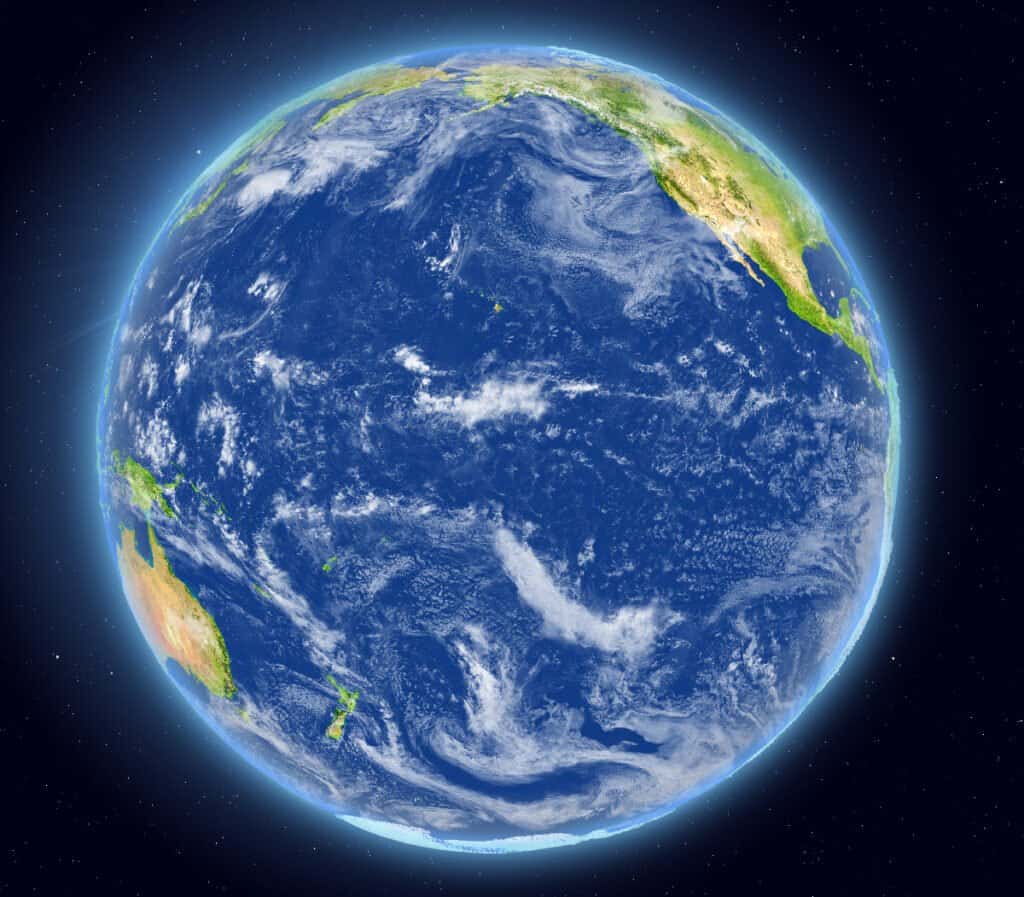
The largest and deepest ocean in the world, the Pacific extends from the Arctic Ocean in the north to Antarctica in the south. It covers 46% of the earth’s water surface and is larger than any landmass on earth.

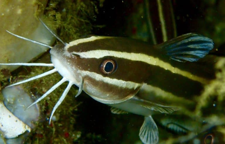
The vast body of water is home to some of the most unusual life forms on earth. These unique animals are part of the sea’s amazing ecological diversity.

Because of its size and reach, there are dozens of countries that have coastlines on the Pacific. Among them are Australia, Chile, Fiji, Mexico, Peru, Thailand, the United States, and Vietnam.

The Pacific Ocean is the largest and deepest body of water on Earth.

The main seas of the Pacific are:

  • Coral Sea.
  • South China Sea.
  • East China Sea.
  • Bering Sea.
  • Solomon Sea.
  • Sea of Japan.
  • Bali Sea.
  • Gulf of California.
  • Gulf of Tonkin.

The Pacific Ocean provides a rich feeding ground for many types of wildlife.

Animals That Live in Coral Reefs: Dugongs

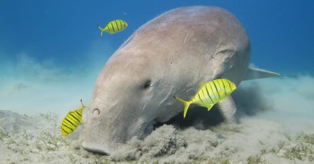
A dugong was the only completely marine mammal that had a diet consisting solely of seagrass.

Important ecosystems of the Pacific include seagrass meadows, which are important breeding and feeding grounds for manatees and dugongs. Coral reefs are vital parts of the food chain. They support thousands of marine species, including reef fish, sharks, and sea turtles.

Green Sea Turtle swimming along tropical coral reef, Bonaire

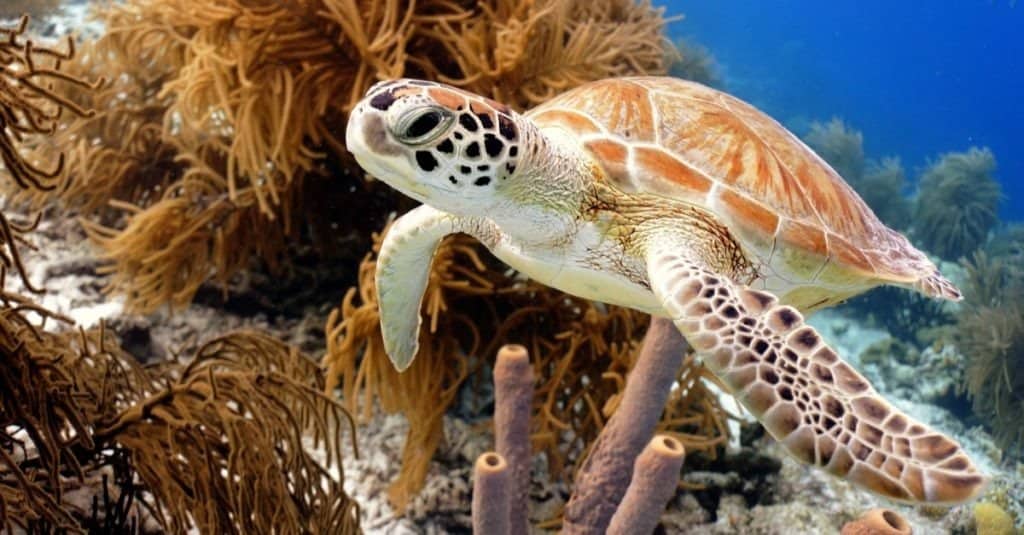
Sea turtles live among seagrasses in the Pacific Ocean.

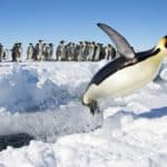
The coastlines of the Pacific Ocean have their own wildlife. In the northern regions, you will find many penguin species, including Galapagos penguins and rockhopper penguins.

Seabirds of the Pacific include gulls, pelicans, cormorants, grebes, loons and terns. Some unique species are the Leach’s storm petrel, the least tern and the Pacific loon.

Close up of a Rockhopper penguin (Eudyptes chrysocome) standing in a group of penguins and Imperial Cormorants on a coastal area of Falkland Islands.

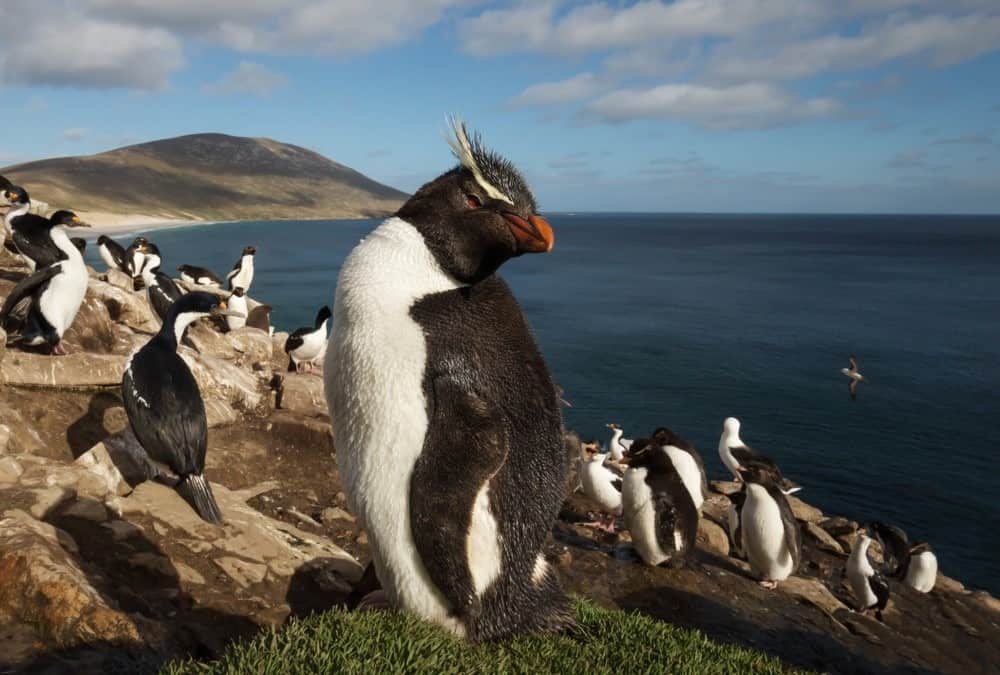
Rockhopper penguins and Imperial Cormorants can be seen on the Falkland Islands, Pacific Ocean.

The Official National Animal of the Pacific Ocean

The Pacific Ocean does not have its own national animal. Many countries border the Pacific. Here are the national animals of some of these countries.

Dolphin

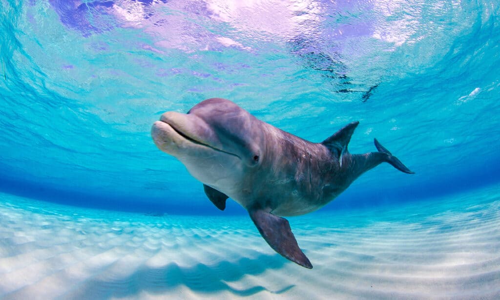
The dolphin is the national animal of Vanuatu, a country that borders the Pacific.

Where To Find the Top Wild Animals in the Pacific Ocean

The coral reefs of the Pacific are some of the best places to see fish and marine mammals. Snorkeling and scuba diving are popular tourist activities in many islands and coastal areas on the Pacific.

side view of blue tang swimming

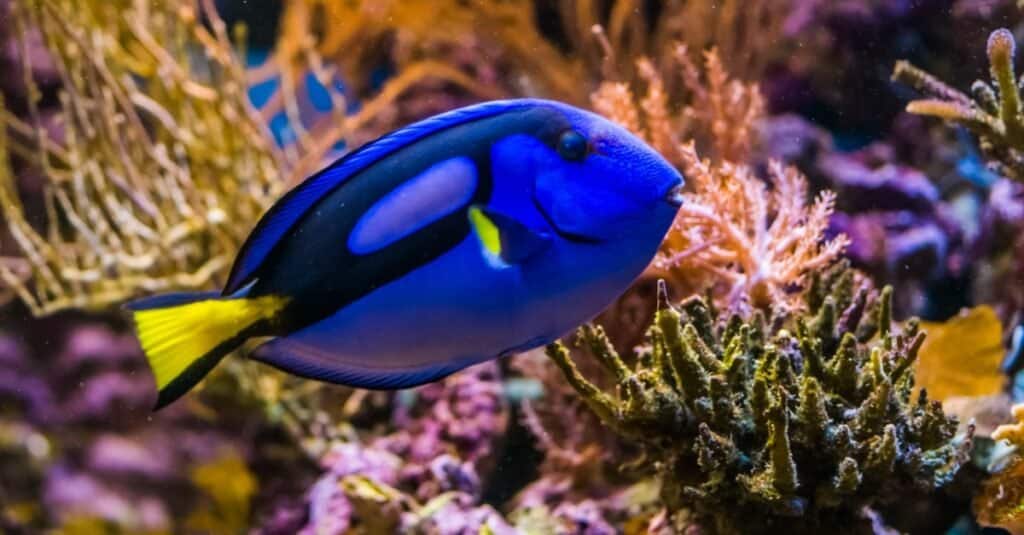
Blue tang helps keep coral reefs from suffocating.

The Great Barrier Reef, located in the Pacific off the coast of Australia is the longest and largest reef complex in the world. It is the largest living thing on Earth and can be seen from space – made up of 600 types of hard and soft coral. The second-largest, the Belize Barrier Reef, off the Pacific coast of Central America, offers opportunities to see many endangered species including sea turtles, manatees and the American marine crocodile.

Whales migrate from feeding grounds in the Bering Sea to south to equatorial waters for mating every year. Gray whales, humpbacks, dolphins, blue whales and orcas make the trip – and are easy to see on guided whale watching tours in California, United States, and many other destinations along the Pacific.

Whale watching, dolphin tours and birding are great opportunities to spot wildlife and waterfowl. Many countries that border the Pacific have conservation areas where you can see this unique local wildlife.

The Most Dangerous Animals in the Pacific Ocean

Great white sharks are the ocean's apex predators.

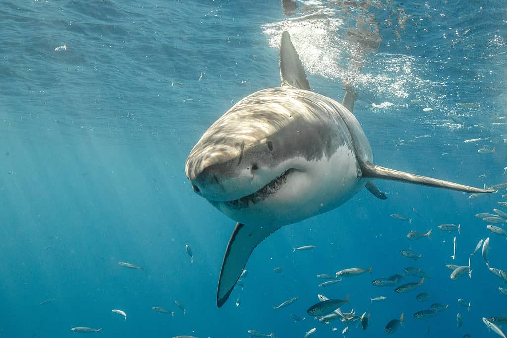
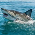
Great white sharks are the ocean’s apex predators.

Sharks

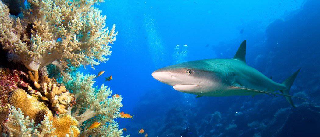
The Pacific is home to many dangerous, aggressive sharks. The great white is one of the largest and deadliest predators in the ocean. They cause one-third of all shark attacks on humans.

Tiger sharks are almost as dangerous. They hunt close to the shore and will eat anything. They are responsible for several attacks on humans every year.

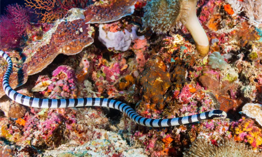
Banded sea kraits are venomous snakes that prey on eels that live on coral reefs.

Sea Snakes

The Pacific Ocean’s sea snakes are some of the most venomous snakes in the world. Also known as coral reef snakes, they are long, colorful snakes who spend most of their lives in the water. Their bites are often painless, but they can be fatal.

Sea snakes only live in the Pacific and Indian oceans. There are no sea snakes in the Atlantic, Caribbean Sea or Red Sea.

Deadliest Jellyfish - Box Jellyfish

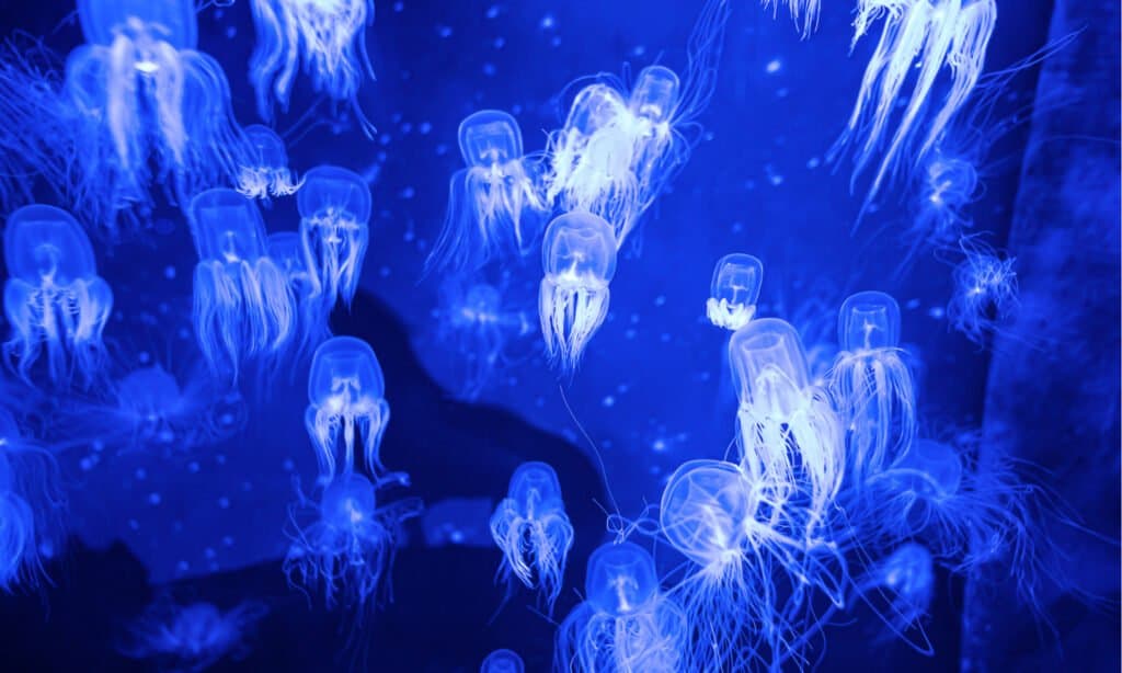
The most venomous box jellyfish are in the Pacific and Indian Oceans.

Jellyfish

The Pacific Ocean is home to many dangerous jellyfish. They include the sea nettle, which have a bell-like shape and can reach 3 feet. Its tentacles can be 15 feet long. The sea nettle’s sting is very painful to humans.

The box jellyfish causes more deaths than any other. The most venomous ones are in the Pacific and Indian Oceans.

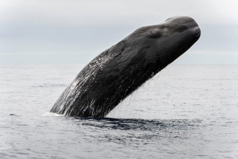
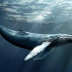
Largest Animal in the Pacific Ocean

Are Blue Whales Endangered - A Blue Whale Near the Surface

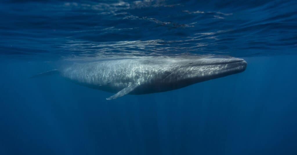
The blue whale is the largest animal in the Pacific Ocean, and the largest animal ever to have lived on earth.

The largest animal on earth is also the largest in the Pacific Ocean. The blue whale can grow up to 100 feet long and weigh upwards of 200 tons! A blue whale’s tongue weighs as much as an elephant and its heart weighs as heavy as an automobile. It’s hard to believe an animal can grow so huge on a diet of tiny krill – but apparently eating four tons a day does the job!

The largest numbers of blue whales are in the eastern North Pacific but they are currently threatened by collisions with ships, entanglement in fishing nets and reduction of zooplankton due to habitat reduction and disturbance from low frequency noise.

This endangered baleen whale has a long and slender body of various shades of gray-blue. This whale is often solitary except for mother-calf pairs but have been seen in gatherings of up to 50 individuals. Blue whales migrate to their summer feeding grounds toward the poles but gather near equatorial waters to breed in the winter. The animals seem to use their memory to know where and when to migrate. Not only are blue whales the largest animal on the planet – they are the largest animal ever to have existed.

Rarest Animal in the Pacific Ocean

Rarest animal - Vaquita NonCOMMERCIAL https://www.flickr.com/photos/nmfs_northwest/21636854959

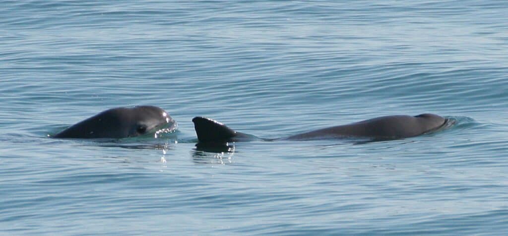
On the brink of extinction, the vaquita is the smallest living species of cetacean and the rarest animal in the Pacific.

Discovered for the first time in 1958, the vaquita is a little porpoise native to Mexico’s Gulf of California. Vaquita are often caught and drowned in fishing nets used in illegal fishing operations. There are only ten vaquita left today.

Vaquita are the smallest living species of cetacean at five feet long and 120 pounds. They have dark patches on their lips that form a thin line from lips to pectoral fin and a large dark ring around their eyes. Its top is dark gray with lighter gray on the sides and a white underbelly with long gray markings. They are most often seen in shallow waters close to shore.

Endangered Animals in the Pacific Ocean

Hawaiian monk seal relaxing in a pool

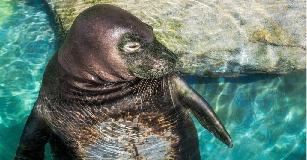
Hawaiian monk seals are almost extinct.

Just like animals on land, sea creatures face worsening threats to their survival. The Pacific ocean, at first glance, seems to be teeming with infinite life, but upon closer inspection, much of the wildlife is in danger. All forms of marine species are at risk, including cetaceans, seabirds, sea turtles, sharks and other fish and invertebrates.

It’s difficult to measure the full extent and causes of marine extinction because the ocean itself is so vast – but there are some obvious culprits. Entanglement in nets and lines, hunting and capture by humans, collisions with ships, pollution and habitat degradation and climate change are some of the causes of marine life decline. Some of the animals in danger are:

  • Bull shark (Carcharhinus leucas): This large, aggressive shark lives in the warmer regions of the Pacific.
  • Sea otter: Sea otters almost became extinct. Hunting bans and conservation programs have helped their populations recover, but they are still endangered.
  • Branch coral (Acropora florida): Branch coral is critical to healthy ocean ecosystems. Climate change and extreme weather events have caused its population to decline.
  • Vaquita (Phoeocna sinus): This tiny porpoise is the smallest and most rare cetacean in the world. Vaquitas are unique to the Gulf of California. Vaquitas, whose name means “little cow,” are on the brink of becoming extinct. They are frequently killed by gillnets used in illegal fishing.
  • Dugong (Dugong dugon): The sea cow is a large, gentle creature like a manatee. It lives in warm waters that are rich in seagrass, which it uses for food. Dugongs are protected, but some people hunt them for their skin, meat and bones.
  • Whale shark (Rhincodon typus): The largest fish in the world, this giant can reach 40 feet or longer. Although they are huge, these sharks are harmless to humans. They feed on plankton and small fish.
  • Hawaiian monk seal (Neomonachus schauinslandi): This seal is endemic to the Pacific coast of Hawaii. The monk seal is almost extinct.

A Vast Ocean of Wildlife

Fastest Sea Animal: Killer Whale

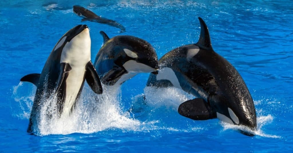
The Orca are the largest of the dolphins and are at the top of the Pacific ocean food chain.

The Pacific Ocean is home to millions of unique creatures. From killer whales at the top of the food chain to sea slugs at the bottom, it is a vast ecosystem. Scientists have not finished identifying all the wildlife that lives in this deep ocean.

Consider that the little vaquita was discovered only 65 years ago and now there are only ten left. There are no doubt more animals like the vaquita out there waiting to be realized and celebrated. Let’s hope to see more new wonders and to see diminishing species rebound. To quote the great oceanographer, Jacques Cousteau, “The sea, the great unifier, is man’s only hope. Now, as never before, the old phrase has a literal meaning: we are all in the same boat.”

Animals Found in the Pacific Ocean

246 species documented in our encyclopedia

Thank you for reading! Have some feedback for us?